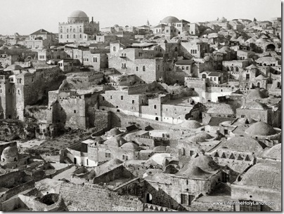
It wasn’t all that long ago that this area looked very different. This photograph, taken from the Temple Mount, looks towards the Jewish Quarter. I don’t have a “today” comparison because sensitivities now do not allow one to access this area.
Dominating the skyline are two domed synagogues, once major landmarks in the Old City: the taller Tiferet Israel (“Glory of Israel”) on the left and the Hurvah (“Ruin”) on the right. Sadly, both structures fell victim to the hostilities of 1948. During the final fighting for the Jewish Quarter in May 1948, both synagogues, which had served as strategic positions for the quarter’s Jewish defenders, were intentionally blown up by Arab forces. Then, with Israeli control of the Old City after 1967, the remains of both buildings were consolidated and preserved as memorials. Until 2006, the Hurvah site sported a memorial arch which became a visual symbol of the new Jewish Quarter and an Old City landmark. Today the Hurvah is being rebuilt, exactly to its original mid-19th century appearance.
In the foreground are the houses and other structures of the Mughrabi Quarter, an Arab neighborhood which covered what is now the expansive Western Wall plaza and the adjacent excavated areas around the Temple Mount. After Israel captured the Old City in the 1967 Six Day War, within a matter of days the Mughrabi Quarter’s residents were forced out and relocated, and most of the buildings seen here were razed. However, the lower floors of some of the houses became the base of an earthen ramp that provided access to the Temple Mount’s Mughrabi Gate from 1967 until 2004, when part of the ramp collapsed. Now, these same houses—and more ancient structures beneath them—are being exposed archaeologically in advance of construction of a new Mughrabi Gate foot-bridge.
This photograph and description are taken from the Jerusalem volume of The American Colony and Eric Matson Collection. The photograph is originally from the Library of Congress, LC-matpc-04722, and the description was written by Tom Powers. The $25 CD includes 685 high-resolution photographs and the equivalent of a 200-page book of annotations such as the one above.

2 thoughts on “The Jewish Quarter before 1948”
In my opinion,Israel presence was of vital importance.
Magnificent photo. It's now my desktop background. For the record, Teddy Kollek, who was mayor in 1967, and had strongly recommended the Mugrabi Quarter be razed, also ensured that residents be relocated to new homes. By 1967, the 'quarter' was really just a dilapidated hovel without electricity or running water. Kollek needed to make room for the thousands of Jews he expected to flood the area when it was learned that the Wall had been repatriated. Work began on June 10, 1967 and was finished two days later. A road was cleared and a few days afterwards, on the Jewish holiday of Shavuot 200,000 people were praying in front of the wall.