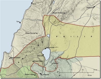
Dave Barrett has let me know that Bible Mapper 2.0 has been released. Bible Mapper 2.0 does a lot:
Bible Mapper is a fully interactive, highly accurate Bible mapping system that helps you quickly and easily create customized maps of the Holy Lands or study a particular period and aspect of Bible history. With Bible Mapper you can:
+ select the types of standard map objects you want to appear on your map (cities, mountain peaks, rivers, roads, political boundaries, etc.)
+ select terrain imagery (relief and elevation, satellite land cover, etc.) or even load your own
+ select which biblical eras to display (only those cities and boundaries that existed during that period will be displayed)
+ change the color or style of almost any object on your map, including the terrain
+ create your own custom objects (or make a duplicate of a standard object) right on your map, including points, lines, areas, and ellipses, and apply a uniform style to it from a style library
+ texturize your lines or boundary areas, allowing the underlying relief to be combined with it
+ import basic geographic data (points, lines, areas, etc.) created by other software and customize it on your map
+ print, save, or export your map, or copy it to the Windows® clipboard
+ quickly calculate the exact distance of a road, river, or custom line object
+ find a place from biblical times just by clicking on it in the Find box
+ read an encyclopedia article about a biblical place
Bible Mapper is the ideal tool for developing customized maps of Bible lands and researching Bible places.
You can get all of the details at www.biblemapper.com. I really like the screenshot below that illustrates some of the new capabilities. The program offers a lot of features and it’s easily worth the $35. But you can download it and try it out before buying.
