fbpx

Aren Maeir, archaeologist of Gath, was at the Jerusalem conference today at which Haggai Misgav presented his reading of the Qeiyafa ostracon.  Maier reports on the meeting and provides an English translation.

You need to go to Maeir’s blog for the data and some of his thoughts, but I offer a brief comment.  If you study these things from afar, you may be unimpressed with the fragmentary inscription and the difficulty of making any sense out of it (indeed, one respondent suggested that it’s a sort of lexical list).  And if this inscription was one of thousands found, it would likely be yet undeciphered or published like many archive texts today.  But this text  apparently dates to 1000 BC, which is a period of great discussion these days among archaeologists and biblical scholars.  To give one example, scholars debate today the degree of literacy at this period; this ostracon indicates proficiency in Hebrew some distance from the capital city of Jerusalem.  Certainly the mention of the words “judge” and “king” at this period are provocative.  It will be interesting to see how the discussion goes and if any views are changed because of this potsherd.
Share:

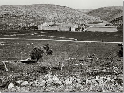
We’re not sure who built the enormous water reservoirs three miles south of Bethlehem, but there’s no evidence that they are related to their namesake.  It is most likely that King Herod or one of his successors built these pools to supply Jerusalem with water.  A complex and sophisticated series of aqueducts was constructed both to feed these three pools as well as to transport the water from here to multiple locations in Jerusalem. 

The water system naturally required repair over the years, but it continued in use, off and on, through the British Mandate period.  One evidence of the significance of these pools is the presence of a fortress built by Suleiman the Magnificent in the 16th century.  (Yes, this is the same ruler who built the walls around the Old City of Jerusalem and constructed the fortress still standing at Aphek-Antipatris.)

The photo below was taken by the American Colony photographers in the early 1900s.

Solomon's Pools from west, mat07571Solomon’s Pools, view from west, early 1900s 

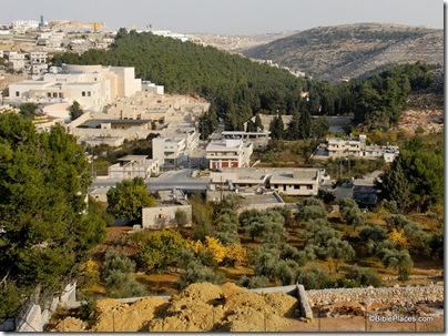
Today the area has changed dramatically, making it difficult even to locate Suleiman’s fortress.  Other attempts that I have made to photograph the three pools have been thwarted by the forest that has been planted in the area.

Solomon's Pools area from west, tb112406464 Solomon’s Pools, view from west, 2006

The top photograph is from the newly published Southern Palestine volume of The American Colony and Eric Matson Collection (originally Library of Congress, LC-matpc-07571).  The CD includes more than 550 high-resolution photographs from the Dead Sea, Jordan River, Jericho, Judean hill country, Shephelah, and Negev.

Share:
About the BiblePlaces Blog

The BiblePlaces Blog provides updates and analysis of the latest in biblical archaeology, history, and geography. Unless otherwise noted, the posts are written by Todd Bolen, PhD, Professor of Biblical Studies at The Master’s University.

Notice

As an Amazon Associate we earn from qualifying purchases. In any case, we will provide honest advice.