One of the most important pieces of land in biblical history is the Central Benjamin Plateau, with the cities of Gibeah, Ramah, Gibeon, and Mizpah.
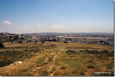
Both of these photos were taken at Mizpah (Tell en-Nasbeh) with a view to the south. The photo above was taken in 1926, before the area was densely settled. A tower is visible on the Mount of Olives in the distance.

This photo was taken from the summit of Mizpah and the tell occupies most of the foreground. The Jerusalem airport runway dominates the right side of the picture. A tower on the Mount of Olives is visible on the horizon (center).
The top photo is from the Northern Palestine volume of The American Colony and Eric Matson Collection (Library of Congress, LC-matpc-05515). The bottom photo is from the Samaria volume of the Pictorial Library of Bible Lands.
