From the Israel Antiquities Authority:
According to Dr. Walid Atrash and Mr. Ya’aqov Harel, directors of the excavation for the Israel Antiquities Authority, “The discovery of another Samaritan synagogue in the agricultural hinterland south of Bet She’an supplements our existing knowledge about the Samaritan population in this period. It seems that the structures uncovered there were built at the end of the fifth century CE and they continued to exist until the eve of the Muslim conquest in 634 CE, when the Samaritans abandoned the complex. The synagogue that is currently being revealed played an important part in the lives of the farmers who inhabited the surrounding region, and it served as a center of the spiritual, religious and social life there. In the Byzantine period (fourth century CE) Bet She’an became an important Samaritan center under the leadership of Baba Rabbah, at which time the Samaritans were granted national sovereignty and were free to decide their own destiny. This was the case until the end of the reign of Emperor Justinian, when the Samaritans revolted against the government. The rebellion was put down and the Samaritans ceased to exist as a nation”.
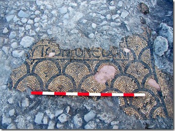
The building that was exposed consisted of a rectangular hall (5 x 8 meters), the front of which faces southwest, toward Mount Gerizim, which is sacred to Samaritans. Five rectangular recesses were built in the walls of the prayer hall in which wooden benches were probably installed. The floor of the hall was a colorful mosaic, decorated with a geometric pattern. In the center of the mosaic is a Greek inscription, of which a section of its last line was revealed:T[]OUTON NEWN
meaning “This is the temple”.
 Samaritan synagogue and farmstead. Photograph: SKYVIEW, courtesy of the Israel Antiquities Authority.