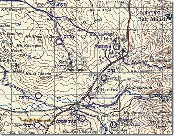
Several years ago I began a study on the location of Eshtaol that was interrupted by a leg injury. Last week I had the occasion to conclude the research and summarize it for another project I’m working on. While this is a bit more technical than most of the blog fare here, there are some insights that may be of interest, even if you are not so concerned with the location connected with the birth and burial of Samson (Judg 13:25; 16:31)
The reason for this study is to reveal a confusion about the site location of Eshtaol that has developed in recent literature. As you will see below, the site of Eshtaol has been “moved” without the guilty parties apparently being aware of what they were doing. This brief review may serve to identify failures in the process and encourage careful work in future study of this and other sites.
1. Michael Avi-Yonah was not the first involved in the identification of this site, but he is a convenient starting point for the purposes of this study. He believed that Eshtaol was located at Tell Abu el-Qabus (Kh. Deir Abu Qabus) on the hill above the Arab village of Ishwa, and he noted that Iron Age remains were found at the site (Encyclopedia Judaica, 1st ed., 6: 280).
2. In 1983, Anson Rainey agreed with Avi-Yonah’s identification, noting that Ishwa preserves the name of Eshtaol, just as many modern names in the Shephelah preserve the ancient ones (“The Biblical Shephelah of Judah,” BASOR 251: 7).
3. In 1986, Zechariah Kallai rejected Deir Abu el-Qabus on grounds that “the finds are incompatible,” preferring instead Kh. Deir Shubeib (Historical Geography of the Bible, 368). Kh. Deir Shubeib is located 1.6 miles (2.7 km) northwest of Tell Abu el-Qabus.
4. In a brief article in the Anchor Bible Dictionary (1992), Raphael Greenberg likewise identified Eshtaol with Khirbet Deir Shubeib, but he was imprecise in claiming that it is “near the village of Ishwa, which retains elements of the ancient name” (2:617).
5. Aaron M. Gale, writing in the Eerdmans Dictionary of the Bible (2000), confused the two sites, identifying Eshtaol with Khirbet Deir Shubeib, but locating it at the site of Tell Abu el-Qabus, 1.5 miles east of Zorah, near Ishwa (425).
6. Rainey in The Sacred Bridge (2006) apparently followed Greenberg/Gale in this mistake, as he writes, “Eshtaol is evidently to be located at Khirbet Deir Shubeib beside the village of Ishwa‘” (141). Kh. Deir Shubeib is 1.8 miles (3 km) west of Ishwa; Tell Abu el-Qabus is next to Ishwa.
On the basis of the observations above, some conclusions may be suggested:
1. Greenberg’s brief article made it unclear that there were two candidates and his imprecision led to later confusion.
2. Gale combined data from the ISBE and ABD articles and in doing so he incorrectly gave the name of Khirbet Deir Shubeib to the site of Tell Abu el-Qabus.
3. Rainey perpetuated Gale’s mistake in his 2005 work. Because The Sacred Bridge will be the standard reference work for historical geographers for the next generation, this mistake may live a long life.
4. The site of Eshtaol has “shifted” not because of convincing evidence but because of careless research and writing.
5. The identification of Eshtaol at either of the sites must be determined on the basis of archaeological study of the two proposed sites. It is doubtful, contrary to initial impressions, that Rainey was intending to follow Kallai’s identification over Avi-Yonah’s. Without further archaeological data, we prefer the conclusion of Avi-Yonah and the initial conclusion of Rainey that Eshtaol is located in the immediate vicinity of the Arab village that preserves its name.
The map below was made by British Mandate authorities, with Israeli additions in purple. The two sites in question are clearly identified. Google Earth users can find Kh. Deir Shubeib at 31.798000°, 34.985200° and Kh. Deir Abu Qabus at 31.785790°, 35.009930°.
My thanks to A.D. Riddle for his assistance with this study.
