(Post by Seth M. Rodriquez)
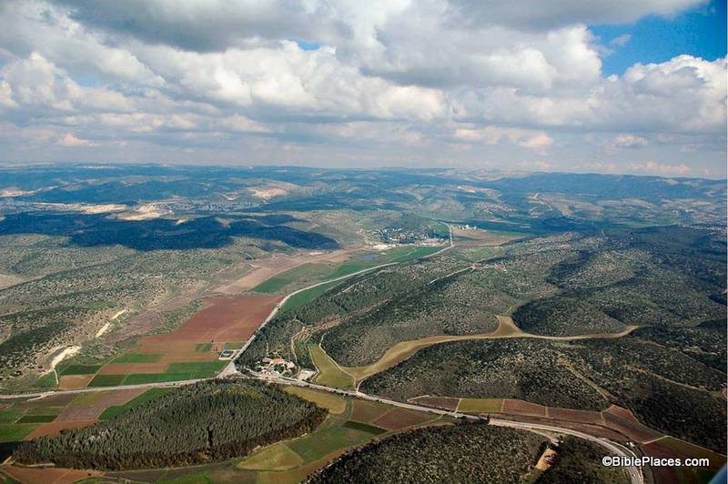
This week’s photo comes from Volume 4 of the revised and expanded edition of the Pictorial Library of Bible Lands and is entitled “Elah Valley Aerial from West” (photo ID #: tb011606772). One of the improvements in the new edition of the collection is the addition of some aerial photos of the Elah Valley which make it easy to pick out the valley from among the hills of the Shephelah. In the photo above, the valley can be seen starting at the bottom left corner, moving diagonally up to the center. (Click on the photo for a higher resolution.)
This photo is extremely useful when discussing the encounter of David and Goliath. First Samuel 17 sets the stage in the following way:
Now the Philistines gathered their armies for battle. And they were gathered at Socoh, which belongs to Judah, and encamped between Socoh and Azekah, in Ephes-dammim. And Saul and the men of Israel were gathered, and encamped in the Valley of Elah, and drew up in line of battle against the Philistines. And the Philistines stood on the mountain on the one side, and Israel stood on the mountain on the other side, with a valley between them. (1 Sam. 17:1-3, ESV.)
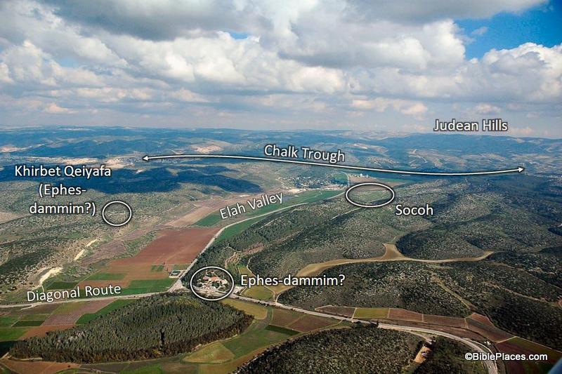
Most of the locations in this passage are visible in this picture. To assist in identifying them, I’m going to pull from one of the PowerPoint presentations included in the Pictorial Library collection:
In this slide the location of the Elah Valley and Socoh are clearly marked, along with possible locations of Ephes-dammim. Azekah is not pictured here, but is located just off the photo to the left. You can easily imagine the Philistine army on one side of the valley and the Israelites on the other, just as it is described in verse 3.
In the background, the Judean Hills are marked which adds to the value of this photo. When teaching on David and Goliath, I like to point out to my listeners that there was much at stake for David in this battle. Not only were the Israelite soldiers facing a deadly enemy and not only was the reputation of Israel’s God on the line, but there was another element that we tend not to think about which relates to geography. If you look at a map of this area you will see that the Elah Valley is an entryway into the Hill Country of Judah, the region where David and his family lived. Three thousand years after the fact we have the advantage of knowing how it turned out, but if David had lost the battle it is possible that the Philistines would have penetrated into the Judean Hills (as they had when they were encamped at Michmash on the Central Benjamin Plateau). This would have put David’s family and neighbors at serious risk. So as David faced Goliath, he was not only fighting for his people and his God … he also was fighting for the safety of his own hometown.
This photo is included in Volume 4 of the Pictorial Library of Bible Lands and can be purchased here.

