(Post by Seth M. Rodriquez)
This seems to be a week where Hebrew scrolls are in the news more often than normal (see here, here, and here), so our picture of the week focuses on the Qumran caves where some of the Dead Sea Scrolls were found. If you have ever studied the Dead Sea Scrolls, you have probably heard statements such as “The Copper Scroll was found in Cave 3,” or “The Habakkuk Commentary was discovered in Cave 1,” or “Cave 11 contained 30 scrolls.” The scrolls are even labeled using the cave number as part of the reference, such as 2Q3 from Cave 2 at Qumran and 11Q19-20 which was found in Cave 11 at Qumran.
Yet with eleven caves in the area with written texts, it quickly becomes difficult to keep them all straight. Fortunately the Pictorial Library of Bible Lands is available to help walk you through the location of each cave, provide pictures of the outside of each cave (and sometimes pictures from within!), and helpful commentary on which scroll was found where. It is a great way of exploring the caves without the cost of traveling to the Dead Sea, without hiking through the blistering heat of the desert, and without any of the risks involved in climbing onto the edge of steep cliffs with loose gravel below your feet. (Thanks for doing all the legwork, Todd!)
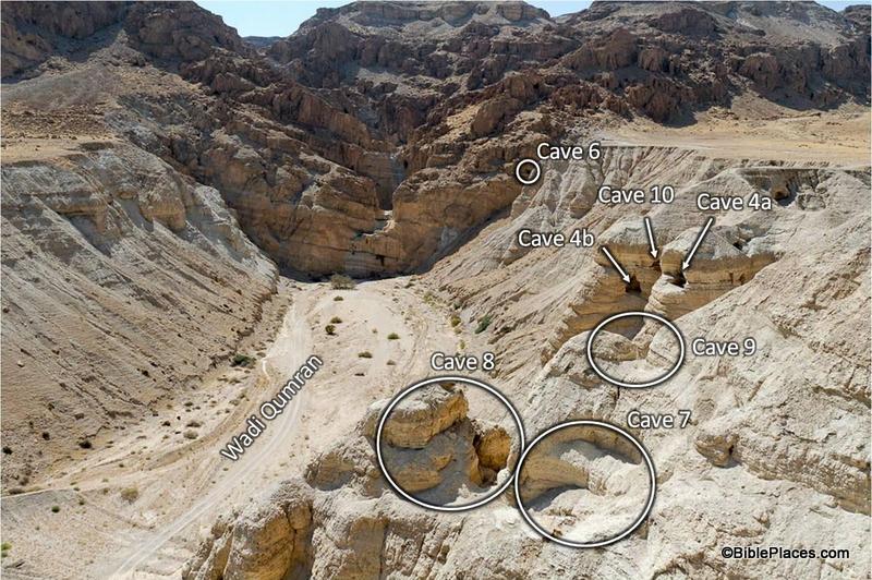
The picture above is a prime example of the resources available in the Qumran Caves collection in Volume 4 of the PLBL (click the image to enlarge). The site of Qumran is to the right, outside of the frame. The photographer is facing west, looking at the edge of the hills of the Judean Wilderness. In the shot, you can see six out of the eleven Qumran caves: Caves 4, 6, 7, 8, 9, and 10. (Please note that the image above includes the labels from one of the PowerPoint® slides. The photograph by itself without any labels is also provided in the collection.) Much of Caves 7 through 10 have eroded away, but their positions can still be seen. Cave 4 yielded a large number of scroll fragments and is typically the one photographed in Bible dictionaries and other reference works.
The value of a shot like this becomes apparent when you are trying to give a lecture to your students on the Dead Sea Scrolls. With a picture like this, you can easily explain the arid terrain, the difficulty of reaching the caves, and their relative positions to one another. Within the collection, each cave is photographed from various angles so that you can get a feel for its size and shape.
The collection is also useful if you are planning a trip to the site. I only wish I could have had these pictures and diagrams with me the last time I visited Qumran so that I could pick out the location of each cave while standing there. The PowerPoint® notes even include instructions on how to get to some of the harder to reach caves when you are on-site (although the reader is cautioned against visiting Caves 1 and 2 because of the difficult terrain).
So whether you are preparing for a lecture on the Dead Sea Scrolls, are packing for a trip to Israel, or just want to learn more about the place where the scrolls were found, the PLBL offers a valuable guide to the Qumran caves.
This photo and over 1,500 others are available in Volume 4 of the Pictorial Library of Bible Lands and is available here for $39 with free shipping. For additional photos and information on the Qumran caves, visit this page on the BiblePlaces website.
