(Post by A.D. Riddle)

The Pictorial Library of Bible Lands is an extensive collection of high-resolution photographs. The photos come two ways: in folders of jpeg images and in pre-made PowerPoint presentations. With the massive revision of the collection some brand new features were included which were not in previous versions, and I would like to highlight two of them. The first of these new features is maps which are included in each PowerPoint presentation.

A total of 43 maps were created for the revision of the Pictorial Library of Bible Lands. There are altogether 383 PowerPoint presentations among the 18 volumes of the Pictorial Library, and about 77% of these contain maps. (The exceptions are volume 15—no map was made of the city of Rome—and volumes 16, 17, and 18, which do not lend themselves to mapping.)

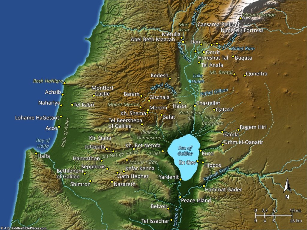
The Pictorial Library contains all the familiar sites, but it also has many biblical and historic sites that are not as well known. The maps are provided to help the user find where a site is located, without having to consult a separate source. Virtually every site and geographic feature which appear in the Library‘s photographs are marked on the maps. This results in maps with a mixture of both modern place names and ancient ones. The places which appear in any given PowerPoint are marked by a red star on the map(s) next to the name so that users can quickly locate that particular site or feature.

The maps use two color schemes to encode information: one scheme for hypsometry and one scheme for labels. First, lower elevations are colored green, intermediate and higher elevations are colored various shades of brown, and the highest elevations are colored white. This is called hypsometric tint, where the change in color represents change in elevation. Green does not necessarily represent areas with vegetation, brown does not necessarily represent arid regions, and white does not necessarily represent snow.

Second, the labels and linework also have a color scheme. The white labels are used for cultural features, that is, features which have been created by human beings, such as settlements, tumuli, or temples. Yellow labels and lines indicate routes, either natural or man-made; green labels indicate geographical features (plains, valleys, mountains); and blue labels indicate water features (rivers, lakes, springs). The yellow dots indicate cities, springs, or other sites such as aqueducts or tumuli.

One thing that cartographers have to consider is changes in coastlines and lakes over time. Will the map represent a historical state, the modern one, or perhaps a mixture of both? The maps in the Pictorial Library of Bible Lands show the modern coastline and the modern Sea of Galilee and Lake Huleh. But the shape of the Dead Sea, as with the majority of maps of Bible lands, dates to 1975 and before. If we had used the modern shape of the lake, only the northern basin would be blue, because today the southern basin is dry due to lowering of the lake level.

The maps are an important new feature in the Pictorial Library of Bible Lands and are one of the ways in which we have tried to make the collection more user-friendly. In a follow-up post, we will describe some of the steps in the map-making process.


[Click here for Part 2]
Share:
(Post by A.D. Riddle)


The site of Khirbet Bal’ama (or Belameh) is identified with ancient Ibleam, mentioned in the account of Jehu’s coup d’état (2 Kings 9:27) as well as in Thutmosis III’s topographical list at Karnak. Khirbet Bal’ama is located on the southern outskirts of Jenin, in the West Bank. The ancient ruins occupy some 9 hectares (22 acres) on top of a 160-foot-high (50 m), natural limestone hill. A walled town existed in the Early Bronze, Middle Bronze, end of Late Bronze/early Iron I, and possibly Iron II Ages.

 Khirbet Bal’ama from east.

The main spring was located at the northeast foot of the hill. Here, early explorers visited the entrance to a water system, though because of bats and debris/wash only a small part of a tunnel could be accessed. About the first 100 feet (30 m) of the tunnel were described in great detail by Gottlieb Schumacher in 1910, and it was excavated in 1973 on a small-scale by Z. Yeivin. The main excavation of the tunnel took place in 1996 and 1997 under the direction of Hamdan Taha.

(Excavations were also conducted on top of the hill, but publication is still forthcoming.) The location of the tunnel is marked in green on this site plan.

Site plan of Khirbet Bal’ama. (Taha and van der Kooij 2007: 15)

What raised my interest in this were reports the last two years of the water system outside Al-Walaja, near Bethlehem. In three seasons, the excavators at Khirbet Bal’ama cleared a total of 380 feet (115 m) of tunnel, but since they did not reach a shaft-entrance at the top of the hill, they suspect a long section of tunnel remains to be explored. Of the tunnel sections which were excavated, archaeologists discovered three entrances to the tunnel, the lowest of which provides access to the cistern/spring of Bir es-Sinjil (or Sinjib). The photo below shows the lowest entrance. The stairs with metal handrails on the right lead up to the second entrance.

Lowest tunnel entrance at the cistern/spring of Bir es-Sinjil.

The tunnel was apparently constructed in the Iron Age, though this is based largely on inference rather than clear, direct evidence. It was secondarily used in the Hellenistic and Roman periods. The cistern/spring was in use all the way up to the modern period. Nearly all of the explored tunnel is rock-cut. The tunnel has a parabolic ceiling between 10 and 16 feet high (3-5 m), and there are 57 rock-cut steps and lamp niches in the walls. The plan below shows the three entrances, steps, and slope of the tunnel. The three excavated entrances are approximately equidistant from one another, with about 100 feet (30 m) of tunnel between them.

Khirbet Bal’ama tunnel plan and section. (Taha and van der Kooij 2007: 18)

I look forward to publication of the excavations conducted on top of hill, and hope for future work to be carried out on the tunnel and the site. The main publication of the tunnel was very difficult for me to locate in the U.S.:

Taha, Hamdan and Gerrit van der Kooij.
2007  The Water Tunnel System at Khirbet Bal’ama. Khirbet Bal’ama Archaeological Project Report of the 1996–2000 Excavations and Surveys, volume II. Ramallah: Ministry of Tourism and Antiquities, Department of Antiquities and Cultural Heritage.

A perhaps more-accessible report can be found in:

Taha, Hamdan.
2000  “Excavation of the Water Tunnel at Khirbet Belameh, 1996-1997.” Pages 1587–1613 in Proceedings of the First International Congress on the Archaeology of the Ancient Near East, Rome, May 18th-23rd 1998. Ed. P. Matthiae and E. Enea, Alessandra. Rome: Università degli studi di Roma “La Sapienza,” Dipartimento di scienze storiche, archeologiche e antropologiche dell’antichità.

Share:
(Post by A.D. Riddle)


A few weeks ago, it was announced that cuneiform texts in the Israel Museum have been added to CDLI, the Cuneiform Digital Library Initiative. I would like to draw attention to two of these inscriptions that should be of interest to teachers and students of the Bible.

The first is the Iran Stele, a limestone stele of Tiglath-pileser III which is preserved in fragments that were found in western Iran. The stele depicts the king and symbols of deities, and the inscription records the king’s annals, including a report that he imposed tribute upon (among others) king Menahem of Samaria (2 Kings 15:19).

Iran Stele of Tiglath-pileser III, Israel Museum

The second is the “Jerusalem Prism” of the Assyrian king Sennacherib. Sennacherib recounts his campaign to Sidon, Philistia, and Judah in 701 B.C. He reports how he defeated the Egyptians at Eltekeh and Tamna (2 Kings 19:9), reinstalled Padi as king of Ekron, and then conquered many of Judah’s towns while confining Hezekiah to Jerusalem like a caged-up bird (2 Kings 18-20).

Sennacherib recorded the account of this campaign on several other prisms and cylinders like this one, such as the Taylor and King Prisms and Rassam Cylinder (British Museum) and the Chicago Prism (Oriental Institute).

Jerusalem Prism of Sennacherib, Israel Museum

Readers may also be interested in the British Museum’s free Image Service, which is not new. Once you search the museum’s online collection for the item in which you have an interest, you will be able to see if there are photographs available. After clicking on the thumbnail, you can enlarge the photo or see if there are “More Views” available. Below the photograph, there should be a link “Image service: Use image.” This link will take you to a page where you can register or sign-in to the Image Service and request the photograph. The website will ask you to select how you intend to use the photograph; options include “Classroom or teaching material” and “Private or professional study or research (without print publication).” Once you submit the request, the photograph will be emailed to you within a day or two. The stated limit is 100 images per month. I successfully requested about a dozen images in one sitting for use in a classroom PowerPoint.

Rosetta Stone, British Museum

Objects one might wish to use in teaching could include: Enuma Elish, Atrahasis, Epic of Gilgamesh, Lachish Reliefs, Rosetta Stone, Black Obelisk, Kurkh Monolith, Taylor Prism, Armana letters, and Lachish letters. One could search for the name of a king from Assyria or Egypt or Rome, or a particular type of object such as coins, lamps, papyri, and so forth.

Bronze wheeled stand with sphinx from Cyprus, British Museum

A helpful source to consult as to what kinds of things are to be found in the British Museum that might have relevance for Bible teaching is:

Fant, Clyde E., and Mitchell G. Reddish.
2008  Lost Treasures of the Bible: Understanding the Bible through Archaeological Artifacts in World Museums. Grand Rapids: William B. Eerdmans.

HT: Jack Sasson

Share:
(Post by A.D. Riddle)

On April 8, the Oriental Institute of the University of Chicago opened its new exhibit, “In Remembrance of Me: Feasting with the Dead in the Ancient Middle East.” The centerpiece of the exhibit is (a cast of?) the Katumuwa Stele, a basalt monument with Aramaic inscription which was discovered at the site of Zincirli in 2008. The exhibit runs until next January.

Katumuwa Stele from Zincirli. (Oriental Institute)

More information about the exhibit is online here. The catalog for the exhibit can be downloaded free in pdf format.

In conjunction with the exhibit, the Oriental Institute is holding a symposium on Sunday, May 4, at 1:00pm. The speakers include:

Virginia Herrmann
David Schloen
Theodore Lewis
Karel van der Toorn
K. Lawson Younger

The symposium is free and open to the public, but registration is required. Information about the symposium is here and online registration is here.

Share:
(Post by A.D. Riddle)

Beginning at 9am on Friday, March 7, and running through 1:30pm on Saturday, the Oriental Institute of the University of Chicago will be hosting its annual symposium. This year’s topic is “The Early/Middle Bronze Age Transition in the Ancient Near East: Chronology, C14, and Climate Change.” The symposium is free and open to the public; no registration is required.

During the late third millennium BC one of the biggest transformations of the ancient Near East took place, affecting almost all regions from Egypt to Anatolia and from the Mediterranean Sea to the Iranian plateau. This period not only saw the collapse of urbanization in the southern Levant at the end of the Early Bronze Age III and the following pastoral Intermediate Bronze, and the rise and decline of the Akkad empire in the Upper Euphrates region, but also the end of the Egyptian Old Kingdom in the Nile valley. In recent years it has been argued that climatic reasons, especially rapid climate change in the late third millennium BC (the so-called 4.2 ka BP event) might have triggered this supra-regional collapse in western Asia and Egypt, linking it to a period of aridification and cooling.
This seminar brings together specialists working in different fields of the ancient Near East, including Egypt, Israel, Lebanon, and Syria, as well as scholars working on radiocarbon dating and climate data. Three major topics will be discussed: The radiocarbon evidence for the mid- to late third-millennium BC Near East, the chronological implications of new dates and how historical/archaeological chronologies should/could be adapted, and — based on this evidence — if and how climate change can be related to transitions in the late Early Bronze Age. Furthermore, written sources concerning late Early Bronze Age Near Eastern interrelations and/or transformation and collapse from Egypt to Syria/Mesopotamia will be taken into account.

Here is the list of presenters and topics. Several of them look very interesting. See the website for additional information. The schedule for sessions is located here.

Elisabetta Boaretto and Johanna Regev
“High Resolution Early Bronze Age C14 Chronology from the Southern Levant: Micro-archaeological Approach for Context Characterization and Archaeological Interpretation”
Aaron Burke
“Amorites and Climate Change: The Negotiation of Amorite Identity during the Transition from the Early to the Middle Bronze Ages”
Michael W. Dee
“Comparing Climatic Signals from the Blue Nile Catchment with the Decline of Old Kingdom Egypt Using High-precision Radiocarbon Dating”
Aron Dornauer
“Bioclimatic and Agro-ecologic Properties of Crop Taxa: A Survey of the Cuneiform Evidence Concerning Climatic Change and the Early/Middle Bronze Age Transition”
Hermann Genz
“The Transition from the Early to the Middle Bronze Age on the Lebanese Coast”
Raphael Greenberg
“No Collapse: Reimagining the Demise of EBA Urbanism in the Southern Levant”
Roman Gundacker
“On the Significance of some Old Kingdom Toponyms and Ethnonyms”
Felix Höflmayer
“A New Chronology for the Late Early Bronze Age Levant and Its Implications for the Collapse of the First Urbanization”
Sturt Manning
“The Chronology and Complications of Climate-related Change ca. 2200 BC in the East Mediterranean/Southwest Asia”
Nadine Moeller
“The Early / Middle Bronze Age Transition in View of Evidence from Egypt during the Old Kingdom and First Intermediate Period: A New Evaluation”
Peter Pfälzner
“The EBA to MBA Transition in the Syrian Jezireh: A Multi-tracked Passage?”
David Schloen
“Economic and Political Implications of Raising the Date for the Collapse of Urbanism in the Early Bronze Age Southern Levant”
Thomas Schneider
“Walking on Shaky Ground: The History of the First Intermediate Period from an Epistemological Perspective”
Glenn Schwartz
“Western Syria and the Early/Middle Bronze Age Transition”
Harvey Weiss, Alexia Smith, Wilma Wetterstrom, R. Meadow, A. K. Patel, D. Reese
“‘Seventeen Kings Who Lived in Tents’: Shubat Enlil before Shamshi-Adad”
Bernhard Weninger
“Archaeological and Palaeoclimatological Data to Evaluate the Potential Impact of the 4.2 ka calBP event in the Aegean and Southeast Europe”
Share:
(Post by A.D. Riddle)

The University of Chicago’s Martin Marty Center for the Advanced Study of Religion is sponsoring a three-part lecture series on “Assyria in Israel, Judea, and the Levant.”

The first lecture presented by Irene Winter (Harvard University, emerita) is on February 11 (Tuesday). No title is yet provided for this lecture.

The second lecture by David Wright (Brandeis University) on “The Covenant Code Appendix (Exodus 23:20–33) and Assyrian Royal Inscriptions” will be given on February 26 (Wednesday).

The last lecture by Elizabeth Bloch-Smith (Saint Joseph’s University) will address “The Assyrian Military Impact on the Ground and in Biblical Texts” on March 13 (Thursday).

The series will take place in the Divinity School’s Swift Hall Common Room on the 1st floor. Lectures begin at 5:00pm and end at 6:30pm. The website for the lectures is here.

Relief from Sennacherib’s palace in Nineveh depicting
the Assyrian siege of Lachish in the reign of Hezekiah.
Share: