fbpx
(Post by A.D. Riddle)

Pottery is the most abundant find in any archaeological excavation. Because everyone used pottery in antiquity, because pottery is so fragile and required frequent replacement, and because pottery is impervious to deterioration from environmental conditions, pottery can be found at every ancient site.

At each dig, potsherds are collected, cleaned and examined. Pottery can tell us about a site’s occupation history, it helps us to date the associated strata and structures, and it can reveal such things as relations (trade or otherwise) between sites and regions.

For decades, the standard reference work has been Ruth Amiran’s Ancient Pottery of the Holy Land from Its Beginnings in the Neolithic Period to the End of the Iron Age (New Brunswick: Rutgers University Press, 1970). This volume is quite useful, although, after nearly 50 years, a refresh is needed. Rumors have circulated for some time that an update, to be edited by Seymour Gitin, was being prepared, but the apparent delay led some to wonder secretly whether there was any truth to the rumors.

Yesterday, they were proven true.

The Israel Exploration Society announced the publication of The Ancient Pottery of Israel and Its Neighbors from the Iron Age through the Hellenistic Period. This is a two-volume work, with additional volumes still in preparation that will cover earlier periods. The only place I can find online to order it is here. There is a part of me that would like to describe these volumes as indispensable, but the $240 price tag gives me pause. Here is the publisher’s description and table of contents:

These two volumes offer a comprehensive corpus of ceramic forms and their typological development organized according to period, geographical region, and cultural tradition. The focus of each chapter is on the most characteristic pottery types and decorative motifs selected from a wide range of sites. Unique in scope, this publication presents a wide range of ceramic types accompanied by specially prepared pottery plates and color photos illustrating thousands of forms. A classic reference work, it serves as an essential resource for archaeologists and other scholars and students of ancient Near Eastern studies. Volumes covering the Neolithic and Chalcolithic periods and the Bronze Age are currently in preparation. 

808 pp., 328 plates with 3,393 images; 34 color photos illustrating 277 vessels; hard cover 27.6 x 21cm.


Volume 1
  • Iron Age I: Northern Coastal Plain, Galilee, Samaria, Jezreel Valley, Judah, and Negev, by Amihai Mazar
  • Iron Age I: Philistia, by Trude Dothan and Alexander Zukerman
  • Iron Age I: Transjordan, by Larry G. Herr
  • Iron Age IIA–B: Northern Coastal Plain, by Gunnar Lehmann
  • Iron Age IIA–B: Northern Valleys and Upper Galilee, by Amnon Ben-Tor and Anabel Zarzecki-Peleg
  • Iron Age IIA–B: Samaria, by Ron E. Tappy
  • Iron Age IIA–B: Judah and the Negev, by Ze’ev Herzog and Lily Singer-Avitz
  • Iron Age IIA–B: Philistia, by Seymour Gitin
  • Iron Age IIA–B: Transjordan, by Larry G. Herr
  • Iron Age IIC: Northern Coast, Carmel Coast, Galilee, and Jezreel Valley, by Ayelet Gilboa
  • Iron Age IIC: Samaria, by Ron E. Tappy
  • Iron Age IIC: Judah, by Seymour Gitin
  • Iron Age IIC: Northeastern Negev, by Itzhaq Beit-Arieh and Liora Freud
  • Iron Age IIC: Philistia, by Seymour Gitin
  • Iron Age IIC: Transjordan, by Piotr Bienkowski
Volume 2
  • Iron Age I–II Phoenician Pottery, by Ephraim Stern
  • Iron Age I–II Cypriot Imports and Local Imitations, by Ayelet Gilboa
  • Iron Age I–II: Greek Imports, by Jane C. Waldbaum
  • Iron Age IIC Assyrian-Type Pottery, by Ephraim Stern
  • Iron Age IB–IIC Egyptian and Egyptian-Type Pottery, by Eliezer D. Oren
  • Persian Period, by Ephraim Stern
  • Persian Period Imports, by Renate Rosenthal-Heginbottom
  • Hellenistic Period, by Andrea M. Berlin
  • Hellenistic Period Imported Pottery, by Renate Rosenthal-Heginbottom
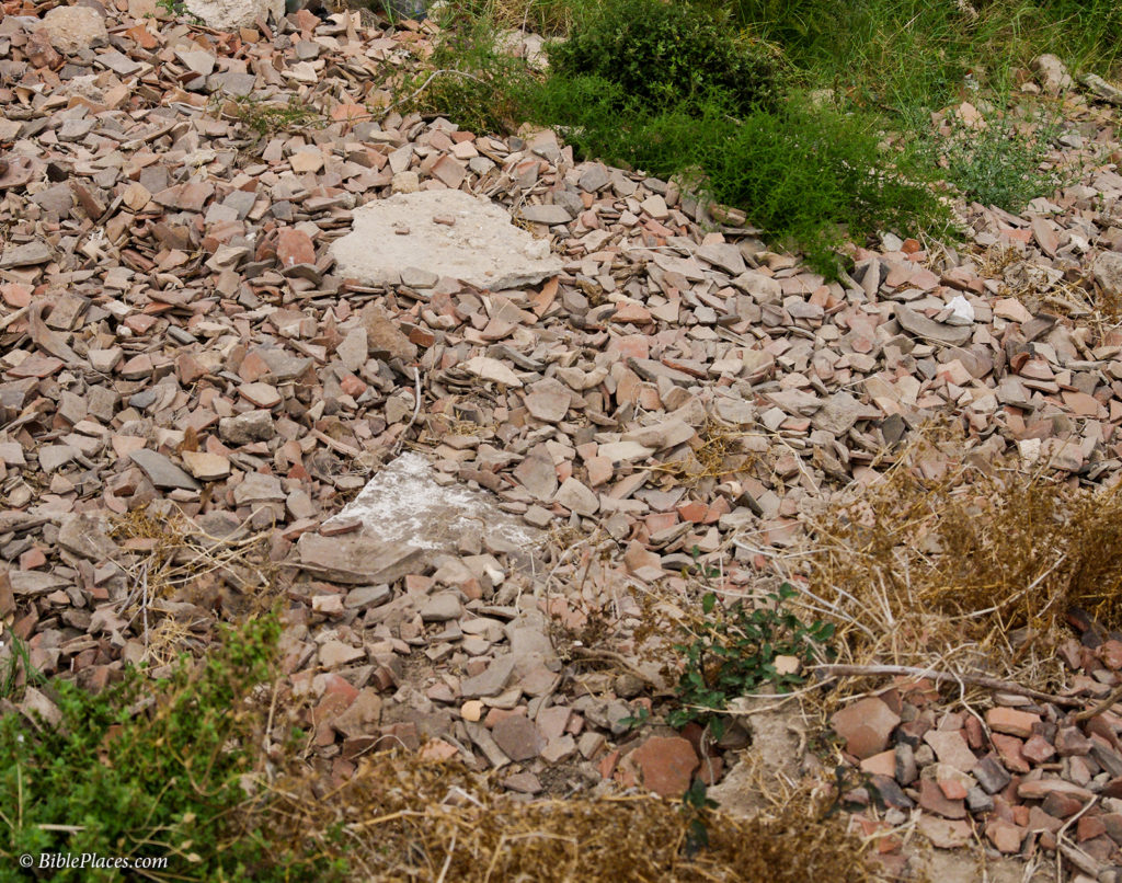
Discarded pottery sherds at Tell Arqa, Lebanon.
HT: Jack Sasson
Share:
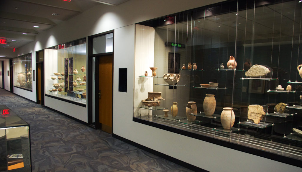
The other evening, I had the opportunity to visit the newly relocated and renovated Wheaton Archaeology Museum. For those who can make a stop, the museum is located on the fifth floor of the Billy Graham Center at Wheaton College. Many of the objects are finds from Tel Dothan, where Wheaton’s Joseph Free conducted excavations between 1953 and 1964.

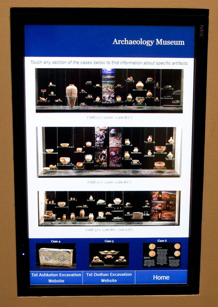
The main displays consist of three glass cases built into the hallway wall. If there are no classes occupying the rooms, you can view the cases from the other side too. To read descriptions about the objects, there are two touch-screen panels. You tap on the object, and a description appears on the screen. Pretty fancy. Be sure not to miss the three smaller displays with ancient lamps, coins of Roman emperors, and an elaborately carved ossuary.

Share:
(Post by A.D. Riddle)


As a follow-up to Todd’s post on using GPS in Jordan, here are the steps my brother used to turn his iPhone into a navigation system. On a trip to Lebanon two years ago, we were able to use my brother’s iPhone as a GPS. His iPhone is an unlocked GSM (meaning that he could swap out SIM cards—this is important!).

1.    At the airport in Beirut, my brother purchased a SIM card and a T-Mobile 3G+ data plan in Lebanon. For our two-week trip, 2GB of data was sufficient, as long as we avoided using apps such as Google Earth which load image tiles every time you swipe or zoom. This near-constant loading of raster images really gobbles up data.

2a.    While within the city of Beirut, my brother discovered that Apple Maps worked better. (Location Services has to be enabled.) It updated our present location faster and with greater precision than other apps, which was quite important in the city so that we did not miss any turns. The street maps in Apple Maps are vector data, so they loaded quickly. The problem with Apple Maps was that road names were in Arabic, so not easy to read. But, since we knew our destination, and we could see where we were at that moment, we could figure out which roads to take.

2b.    Outside Beirut on the way to the next city, Google Maps worked better. Google Maps did not update our position as quickly, but it did show more of the smaller roads (very helpful!) and was pretty accurate. The street maps in Google Maps are also vector data, so the maps loaded quickly.

2c.    Once we were within a mile or so of whatever obscure site that we were trying to find, my brother used OpenStreetMap within the app GaiaGPS. (GaiaGPS is $20 in the App Store; it works on both iOS and Android phones.)

As Todd did, before leaving on our trip, we located all sites in Google Earth. The Google Earth kml file was converted to a gpx file using the free kml2gpx website. My brother then loaded the gpx file into GaiaGPS. As with Google Maps, OpenStreetMap also showed more of the smaller roads and showed where our Google Earth site was located in relation to our position. Because OpenStreetMap is tile-based, sometimes it took the maps a little longer to load. To get around this, we could cache our route the night before, though sometimes we did not always know exactly which roads we would be using, or we did not cache all the zoom levels that we needed. GaiaGPS was not quite as fast at updating our position as Google Maps, but my brother could force GaiaGPS to update simply by snapping a photo within GaiaGPS. (Since GaiaGPS geotags photos, taking a photo forced GaiaGPS to update our location in order to write the coordinates to the jpg image file.)

3.    We also used GaiaGPS to store waypoints. In essence, this feature kept track of the path we travelled by recording GPS coordinates every few seconds. Once we returned home, we were able to use the waypoints (a gpx file) from GaiaGPS to geotag all my photos using the free COPIKS PhotoMapper. The COPIKS app marries waypoint coordinates with a photograph based on matching timestamps. (It is important beforehand to sync up the date-time on your camera with the date-time on the iPhone.) COPIKS then writes the coordinate data to the jpg image file.

4.    As Todd did in Jordan, we found screen captures from Google Earth to be helpful on several occasions. Rather than printing them, we loaded the images onto an iPad for reference.

Share:
(Post by A.D. Riddle)

On Thursday, October 1, at 7:15 pm, the Biblical and Theological Studies Department at Wheaton College will host a screening of the film Patterns of Evidence. After the film Daniel Block will moderate a panel discussion including Daniel Master and James Hoffmeier. The event will take place in Wheaton College’s Billy Graham Center 105, Barrows Auditorium. It is free and open to the public. Information about the event can be found here.

Share:
(Post by A.D. Riddle)


About five months ago, we wrote about (1) the series Royal Inscriptions of the Neo-Assyrian Period (RINAP) and (2) the importance of the Neo-Assyrian period for biblical history.

At that time we mentioned a few advantages to having the physical volumes over the digital versions at ORACC (The Open Richly Annotated Cuneiform Corpus), namely, the introductions to the texts and bibliography.

Since then, ORACC has been expanding the RINAP Online to include more resources. Now, you can find the following:

RINAP 1 = Tiglath-pileser III and Shalmaneser V

The same resources are made available for:

The following resources are provided for all three RINAP volumes:

The following volumes are in the pipeline:
RINAP 2 = The Royal Inscriptions of Sargon II
RINAP 5 = The Royal Inscriptions of Ashurbanipal, Aššur-etel-ilāni, and Sîn-šarra-iškun

In our piece, we listed all the RIM and RINAP volumes. They are also listed on this page.

HT: Grant Frame via Agade List

Share:
In addition to the free lectures that we mentioned last week, here are two more for this month.

On Saturday, September 12, at 5:00 pm, Khadiga Adam and JJ Shirley will be speaking on “ARCE Conservation Field Schools and Theban Tomb 110” at the Chicago Chapter of the American Research Center in Egypt. The lecture will take place at the Oriental Institute, University of Chicago, LaSalle Banks Room (on the lower level). More information can be found here.

Of the more than 900 non-royal tombs located in what is today called the “Theban Necropolis” on the west side of the Nile in Luxor, few are as intriguing as “Theban Tomb 110.” Tomb 110 belonged to a man named Djehuty, who served as a royal butler and herald for two 18th Dynasty kings: the powerful queen-turned-king Hatshepsut, and her stepson and successor Thutmose III. Djehuty’s tomb was discovered and superficially published in the 1930s by one of the great early Egyptologists, Sir Norman de Garis Davies. But, the tomb was lived in during modern times, and completely blackened by fires, so Davies could not discern many of the inscriptions and scenes. Since 2012 the American Research Center in Egypt (ARCE) has run field schools to excavate and conserve this tomb, making it possible to conduct a new and more thorough study of the tomb by re-recording its tomb scenes and inscriptions, a process known as “epigraphy.”
          This talk will present the results of the current epigraphy project in Theban Tomb 110, funded by ARCE through an AEF grant and run as field school to train Egyptian Inspectors in this specialized skill. The students’ work has already brought to light new information about the tomb’s construction, the tomb owner, and the kings whom he served.
          Khadiga Adam will open the evening with an overview of the trainees’ progress during the ARCE conservation programs that started in 2007 and have trained over 300 Ministry of Antiquities conservators and technicians from Upper Egypt. The resulting impact will be illustrated by past and present projects, including the current work of ARCE Luxor archaeologists.
          JJ Shirley will discuss the ARCE’s Conservation Field School at Theban Tomb 110 (TT110) that started in February 2013. The badly damaged tomb gives the trainees a wonderful opportunity to learn about the treatment and conservation of the many types of decay and damage that they will encounter during their careers. To date, ARCE has trained 24 Ministry of Antiquities (MOA) supervisors, conservators and technicians in this tomb. Each season, ARCE introduces new advanced techniques in a step by step learning process with special emphasis on building the MOA’s knowledge and use of conservation methods and materials.

On Thursday, September 24, 7:00-9:00 pm, Jeffrey H. Tigay (U. Pennsylvania) will speak on the topic “Jewish Interpretation of Deuteronomy’s Command to Annihilate the Canaanites.” The lecture will take place at Barrows Auditorium, Billy Graham Center, Wheaton College. The lecture is free and open to the public.

UPDATE: More information can be found on this webpage.

Share:
About the BiblePlaces Blog

The BiblePlaces Blog provides updates and analysis of the latest in biblical archaeology, history, and geography. Unless otherwise noted, the posts are written by Todd Bolen, PhD, Professor of Biblical Studies at The Master’s University.

Notice

As an Amazon Associate we earn from qualifying purchases. In any case, we will provide honest advice.