fbpx
(Post by A.D. Riddle)

Oftentimes, while researching archaeological sites and/or biblical places, I come across things like this:

map reference 193.142
M.R. 219156
1972 1954

These are grid coordinates for sites. One encounters them in key works such as The New Encyclopedia of Archaeological Sites in the Holy Land (5 vols.), Anchor Bible Dictionary, or the volumes from the archaeological survey of Israel. I want to locate these sites in Google Earth, but how do I convert them? (This subject came to mind while reading Chris McKinny’s post on Shaaraim [see here].)

There are two coordinate systems for Israel, the Old Israeli Grid and the New Israeli Grid. Sometimes these are abbreviated OIG or NIG, but typically no indication is given as to which coordinate system is being used. (To read more about OIG, see this page, and for NIG this page.) I have found that most coordinates are according to OIG, even in newer publications. I am going to assume we are using OIG. (If not, hopefully the results are so wrong that one can tell right away that they are not OIG. This point highlights the fact that you need already to have some kind of rough idea where the right location is so that you can verify the results.)

The coordinates should have an even number of digits. Sometimes they are divided in half by a space, period, or slash, but other times there is nothing separating the string of digits.

If you are given six digits, then the first three digits give one coordinate and the second three digits give the other coordinate. If you are given eight digits, then the first four are one coordinate and the second four are the other. And so on.

The first coordinate gives the easting position (think longitude or x-axis), and the second coordinate gives the northing position (think latitude or y-axis). In other words, the coordinates give you lon/lat. This is the opposite order we normally use of lat/lon for geographic coordinates.

The first (easting, x) coordinate is actually always six digits. If you are only given three digits, then you need to append three zeros to the right side. If you are given four digits, then append two zeros to the right side.

The second coordinate, on the other hand, can be six or seven digits, and is a little more complicated. For the second (northing, y) coordinate, if you are given three digits, then you have to append a “1” to the left side and three zeros to the right side.

With these expanded coordinates, you can now make the conversion using a fantastic website named “The World Coordinate Converter.” (Thanks to Shawn French for finding this gem.) In the top right, from the first dropdown list, scroll down to Israel and select Israel 1923. This is the Old Israeli Grid.

Then, paste the coordinates into the fields. Below this in the second dropdown list, you will need to select “WGS 84/Pseudo-Mercator.” It is found under *World, which is the first group of reference systems. This is the datum used by Google Earth. Finally, click Convert and voila! you have coordinates that you can copy/paste into Google Earth/Maps.

Here are three examples.

Khirbet Jazzir

  1. Anchor Bible Dictionary gives the coordinates 219156 for Khirbet Jazzir. This is thought to be the most likely site for the Levitical city Jazer.
  2. The easting (longitude, x-axis) coordinate is 219. We need to add three zeros to make this a six digit number, namely 219000.
  3. The northing (latitude, y-axis) coordinate is 156. We need to add a “1” to the left and three zeros to the right to get 1156000.
  4. Now go to “The World Coordinate Converter,” select Israel 1923, and paste in the expanded coordinates in the same order they were given to us, 219000, 1156000. Make sure you are converting to “WGS 84/Pseudo-Mercator” and click the Convert button.
  5. The converter generates the following lat/lon coordinates that I can then paste right into Google Earth: 31.996063441518004, 35.728730514891744. Make sure lat is first, and lon is second.

Tell el-Maṣfā

  1. In an article by Israel Finkelstein, Ido Koch, and Oded Lipschits, entitled “The Biblical Gilead: Observations on Identifications, Geographic Divisions and Territorial History,” it is proposed that Mizpah of Gilead be identified with Tell el-Maṣfā.
  2. The coordinates given are 227193.
  3. This gets expanded to 227000, 1193000.
  4. The convertor returns 32.32932657748971, 35.815608335148326 which can be used in Google to locate the site. (We note that these coordinates do not correspond to the hill that they have marked on the p. 143 photograph. It looks to me like their arrow needs to be moved about 1 inch to the left.)

Karm er-Ras

Finally, I was recently asked to make a map that shows Karm er-Ras in Galilee. The Hadashot Arkheologiyot article for this site gives very precise coordinates for each excavation area, both NIG and OIG. The OIG coordinates for Area A are 181580/239335. These are already six digits, so all I need to do is paste them into “The World Coordinate Converter” to get 32.74860752349965, 35.33387296365357.

Additional Notes

The OIG and NIG coordinates are measured in meters. If you are given three digit coordinates, then the accuracy could be off by about half a kilometer. If you are given all six digits, then your accuracy is sub-meter.

If the “The World Coordinate Converter” fails to load the Converter, you can still use the website to get the information you want. Once you select Israel 1923 and paste in your coordinates, a placemark will appear on the map with an info-window. The lat/lon coordinates that you can use in Google Earth appear within this info-window.

For batch conversions, you can supposedly import a CSV into Eye4Software Coordinate Calculator 3.2 (Windows only).  I have not successfully completed a batch conversion, but the software claims it can do so.

Share:
(Post by A.D. Riddle)

Yesterday we mentioned the Royal Inscriptions of the Neo-Assyrian Period publication project. The Neo-Assyrian kingdom (sometimes empire) began with the reign of Tiglath-pileser II ca. 966 B.C. and continued for 3-1/2 centuries until 609 B.C. when the Assyrians were definitively defeated by the Babylonians.

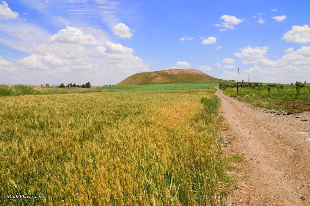
The first Neo-Assyrian king to have direct contact with Israel was Shalmaneser III, who ruled 858-824 B.C. Shalmaneser III is not mentioned in the Bible, but he mentions two kings of Israel in his inscriptions. A version of Shalmaneser III’s royal annals was inscribed on the Kurkh Monolith, a stele found at the base of the tell at Kurkh (now modern Üçtepe), near the Tigris River in Turkey. The annals recount (among other things) Shalamaneser III’s campaign in 853 B.C. to Qarqar where he fought a coalition of kings including Irhuleni of Hamath, Hadad-ezer of Damascus (possibly Ben-Hadad II), and Ahab of Israel. See Michael Caba’s post about the Kurkh Monolith here.


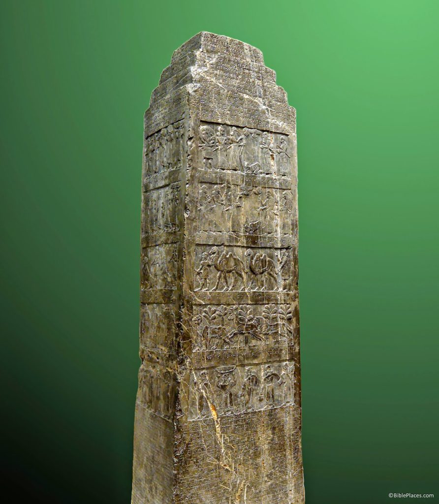
This same Neo-Assyrian king about 12 years later, in 841 B.C., campaigned against Damascus and in the process received tribute from Jehu of Israel. The event is recorded in several of Shalmaneser III’s inscriptions and is pictorially represented on the Black Obelisk. Again, see Michael Caba’s post about this monument here.

Black Obelisk (British Museum).

Following were a series of five kings who oversaw a period of relative weakness in the Neo-Assyrian monarchy: Shamshi-Adad V, Adad-nerari III, Shalmaneser IV, Ashur-dan III, and Ashur-nerari V. Although military campaigns were still conducted, this period saw rebellions in the heartland of Assyria, increase in the number of years the Assyrian king did not go on campaign, the rise in power of Assyrian governors who in some ways behaved as kings in their own right, and the massive expansion of Urartu to the north which posed a threat to Assyria.

None of these five kings are mentioned in the Bible, and only Adad-nerari III mentions a biblical king. During a campaign against Damascus in 796 B.C., Adad-nerari III received tribute from Jehoash of Israel.

The next king of Assyria, Tiglath-pileser III, paved the way for the Assyrian empire’s greatest expansion and he initiated the demise and eventual fall of the northern kingdom of Israel. Tiglath-pileser III and the next five kings are all mentioned by name in the Bible. Furthermore, these kings mention several kings of Israel and Judah in their inscriptions.

  • Tiglath-pileser III
    • 2 Kings 15:29; 2 Kings 16; 1 Chronicles 5:26; 2 Chronicles 28:20
    • Mentions Menahem of Israel, Pekah of Israel, Hoshea of Israel, Uzziah/Azariah of Judah, and Ahaz of Judah
  • Shalmaneser V
    • 2 Kings 17:3; 2 Kings 18:9
    • Conquers the northern kingdom of Israel in 722/721 B.C.
  • Sargon II
    • Isaiah 20:1 = campaign to Ashdod in 712 B.C.
  • Sennacherib
    • 2 Kings 18–19; 2 Chronicles 32; Isaiah 36–17
    • Mentions Hezekiah of Judah (see Michael Caba’s post here)
  • Esarhaddon
    • 2 Kings 19:37; Ezra 4:2; Isaiah 37:38
    • Mentions Manasseh of Judah
  • Ashurbanipal
    • Ezra 4:10
    • Mentions Manasseh of Judah
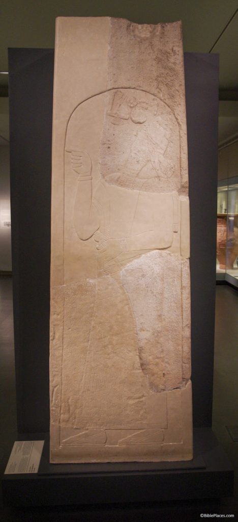
Stele of Tiglath-pileser III from Iran in which he mentions Menahem (Israel Musum).

There were at least four more kings after Ashurbanipal, but none of these are mentioned in the Bible, nor do any of them mention kings of Judah, for the Neo-Assyrian kingdom collapsed and ceased to exist within 18 years. The Medes captured the city of Ashur in 614 B.C., and the city of Nineveh in 612 B.C. The Babylonians pursued the Assyrians westward, defeating them at Harran in 610 B.C. and finally at Carchemish in 609 B.C.

Share:
(Post by A.D. Riddle)

The Royal Inscriptions of Mesopotamia (RIM) volumes are an excellent resource for reading and studying inscriptions by the kings of Babylonia, Assyria, Ur, and other Mesopotamian kingdoms. The texts are presented in transliteration and English translation, with brief introductions, catalogues of text exemplars, and bibliography. The RIM project was directed by A. Kirk Grayson at the University of Toronto.

RIM is divided up into RIME, RIMB, and RIMA. RIME = The Royal Inscriptions of Mesopotamia Early Periods, and includes volumes 1, 2, 3/1, 3/2, and 4.

  • Frayne, Douglas R. 2008. Presargonic Period (2700–2350 BC). The Royal Inscriptions of Mesopotamia Early Periods 1. Toronto: University of Toronto Press.
  • Frayne, Douglas R. 1993. Sargonic and Gutian Periods (2334–2113 BC). The Royal Inscriptions of Mesopotamia Early Periods Volume 2. Toronto: University of Toronto Press.
  • Edzard, Dietz Otto. 1997. Gudea and His Dynasty. The Royal Inscriptions of Mesopotamia Early Periods 3/1. Toronto: University of Toronto Press.
  • Frayne, Douglas R. 1997. Ur III Period (2112–2004 BC). The Royal Inscriptions of Mesopotamia Early Periods 3/2. Toronto: University of Toronto Press.
  • Frayne, Douglas R. 1990. Old Babylonian Period (2003–1595 BC). The Royal Inscriptions of Mesopotamia Early Periods 4. Toronto: University of Toronto Press.

RIMB = The Royal Inscriptions of Mesopotamia Babylonian Periods, of which only volume 2 was published. It would seem that RIMB volume 1 was supposed to have covered the Kassite Babylonian period, but I have seen nothing about the fate of this volume.

  • Frame, Grant. 1995. Rulers of Babylonia: From the Second Dynasty of Isin to the End of Assyrian Domination (1157–612 BC). The Royal Inscriptions of Mesopotamia Babylonian Periods 2. Toronto: University of Toronto Press.
RIMA = The Royal Inscriptions of Mesopotamia Assyrian Periods and includes volumes 1, 2, and 3.

RIMA 2 and RIMA 3 in particular get a lot of use in my own studies.

  • Grayson, A. Kirk. 1987. Assyrian Rulers of the Third and Second Millennia BC (to 1115 BC). The Royal Inscriptions of Mesopotamia Assyrian Periods Volume 1. Toronto: University of Toronto Press.
  • Grayson, A. Kirk. 1991 Assyrian Rulers of the Early First Millennium BC I (1114-859 BC). The Royal Inscriptions of Mesopotamia Assyrian Periods Volume 2. Toronto: University of Toronto Press.
  • Grayson, A. Kirk. 1996 Assyrian Rulers of the Early First Millennium BC II (858-745 BC). The Royal Inscriptions of Mesopotamia Assyrian Periods Volume 3. Toronto: University of Toronto Press.
The RIM volumes are not cheap, and many of them are now out of print. Several can be ordered from the University of Toronto Press’s website.

The RIM project was launched in 1978, and sometime around 2006 or 2007 (I am not sure of the exact chronology), it was discontinued. The last volume was published in 2008. I think the main cause was lack of continued funding. Unfortunately, the Assyrian royal inscriptions stopped at Ashur-nerari V, right before things get really interesting for the history of the southern Levant.

In 2006, Grant Frame, at the University of Pennsylvania, assumed direction of publication of the royal inscriptions, and thanks to Eisenbrauns, the Assyrian portion of the RIM project was revived under a new name, the Royal Inscriptions of the Neo-Assyrian Period, or RINAP. First, the RINAP project improved on the earlier RIM volumes by creating online indexes of personal names, deity names, place names, temple names, astronomical names, and so forth. Second, RINAP has already produced four volumes in print covering the reigns of Tiglath-pileser III, Shalmaneser V, Sennacherib, and Esarhaddon. In addition to the print volumes, RINAP has made the texts available online, in transliteration and English translation. You miss out on the introductions to the texts (important for making sense of them) and the bibliography that appear in the print versions, but you get the added feature of hyperlinked text which connects to a glossary and list of attested forms.

There are some other resources as well. The RINAP website is worth taking a little time to explore.

  • Tadmor, Hayim, and Shigeo Yamada. 2011. The Royal Inscriptions of Tiglath-Pileser III (744–727 BC) and Shalmaneser V (726–722 BC), Kings of Assyria. Royal Inscriptions of the Neo-Assyrian Period 1. Winona Lake: Eisenbrauns.
  • Grayson, A. Kirk, and Jamie Novotny. 2012. The Royal Inscriptions of Sennacherib, King of Assyria (704–681 BC), Part 1. The Royal Inscriptions of the Neo-Assyrian Period 3/1. Winona Lake: Eisenbrauns.
  • Grayson, A. Kirk, and Jamie Novotny. 2014. The Royal Inscriptions of Sennacherib, King of Assyria (704–681 BC), Part 2. The Royal Inscriptions of the Neo-Assyrian Period 3/2. Winona Lake: Eisenbrauns.
  • Leichty, Erle. 2011. The Royal Inscriptions of Esarhaddon, King of Assyria (680–669 BC). Royal Inscriptions of the Neo-Assyrian Period 4. Winona Lake: Eisenbrauns.

We were happy to hear just last week that Grant Frame has been awarded another grant for the RINAP project (see here). Volume 2, the reign of Sargon II, is nearly complete, and the article states that the grant money will be used for volume 5, the reign of Ashurbanipal.

Grant Frame, an associate professor of Assyriology in the Department of Near Eastern Languages & Civilizations in the School of Arts & Sciences (SAS) has been awarded a two-year, $250,000 National Endowment for the Humanities (NEH) grant for his Royal Inscriptions of the Neo-Assyrian Period (RINAP) Project.
The grant brings the total NEH funding Frame has received for the RINAP Project to nearly $950,000 since 2008.

Four books have been published so far by the RINAP Project; Frame is working on a fifth. The latest grant is for a sixth book, which will include most of the official inscriptions of Ashurbanipal (668c.-631 B.C.E.). Frame hopes to complete the Project with a seventh volume containing the remainder of Ashurbanipal’s inscriptions and those of his successors, up until the fall of Assyria.


We are grateful to Eisenbrauns and Grant Frame for taking on the task of seeing through to completion the publication of these royal inscriptions. Jamie Novotny also appears heavily involved in several steps of the project as well, and there are surely many others. The RINAP volumes are available from Eisenbrauns here.

HT: Agade
Sources:

Royal Inscriptions of Mesopotamia Project

RIM volumes listed at Eisenbrauns—all out of stock.

RIM volumes available from University of Toronto Press

History of the RINAP Project, by Jamie Novotny
Share:
(Post by A.D. Riddle)

On January 20, Google announced that Google Earth Pro is now available for free (see here.) Google Earth un-Pro was always free, but prior to this, Google Earth Pro required an annual subscription that cost $399.99.

The announcement lists some of the advantages to using the Pro edition.

Google Earth Pro has all the easy-to-use features and detailed imagery of Google Earth, along with advanced tools that help you measure 3D buildings, print high-resolution images for presentations or reports, and record HD movies of your virtual flights around the world. 

Google Earth works on both Windows and Mac. The program can be downloaded here. The free license key is GEPFREE.

To get started with some of the Pro features, this blog describes Movie Maker, and this help describes the use of Super Overlays for importing hi-resolution overlays into Google Earth Pro. Another option for importing large overlays is MapTiler.

Share:
(Post by A.D. Riddle)

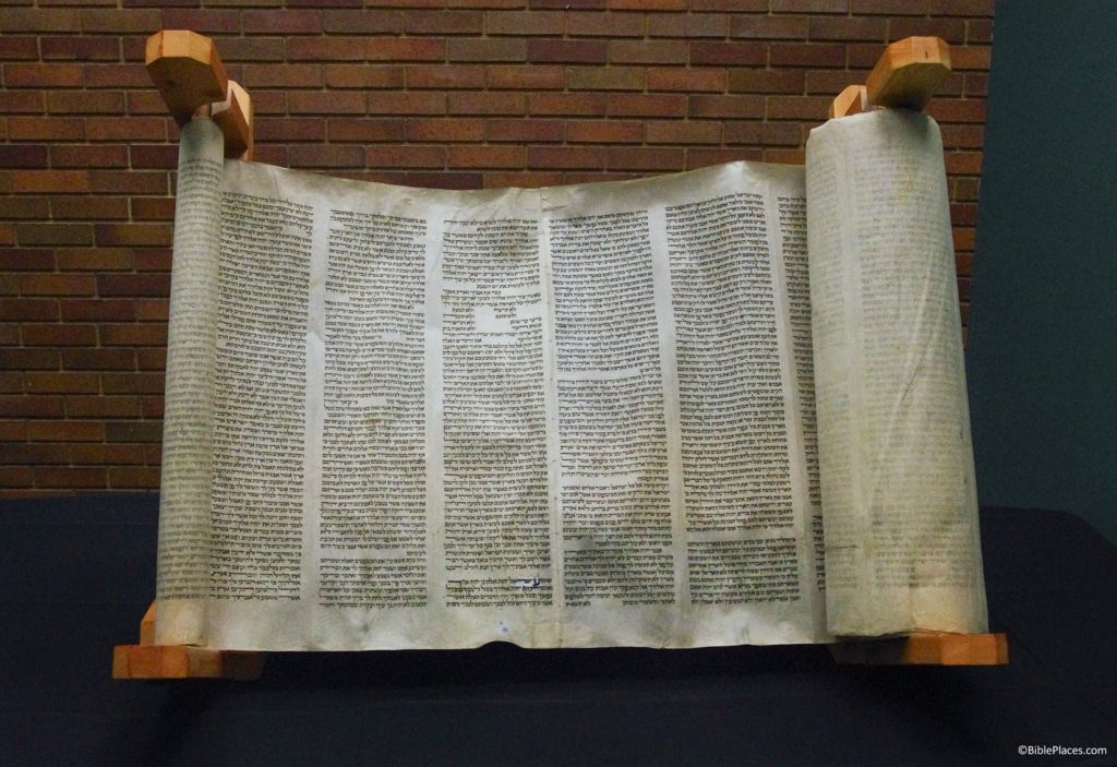
We are a little late getting to this, but it might be of interest to some. Back on September 18, 2014, Trinity Evangelical Divinity School held a dedication service for a Torah scroll that was gifted to the school. The scroll originated in Germany and dates to the late 1400s or early 1500s. The sign presently displayed with the Torah states:

The Trinity Ashkenazi Torah Scroll
An extraordinary, generous gift from the Ken and Barbara Larson Family

This spectacular Ashkenazi Torah from Germany dates between the late 15th and early 16th century A.D. (roughly around the time of Martin Luther). The scroll’s pagination and orthography clearly indicate this date, while its style, the preparation of its skins and its ink all clearly indicate a German provenance. Such a date makes it among the earliest 2% of surviving German Torah scrolls. It has been used continuously for nearly 500 years and survived the Nazi Holocaust, the most horrific chapter in Jewish history.
It is approximately 100 feet long and is written in columns of 59 lines throughout. It contains numerous fascinating orthographic features encountered in medieval scrolls that were repressed by the rabbis around 1600 A.D. The Torah is filled with elegant magna letters, small or raised letters, dotted letters and inverted nuns—all related to early Jewish scribal traditions.

The official announcement of the dedication contains a few more details about the scroll, and a report written afterwards includes even more description as well as photos of the event.

  • The scroll is valued at over $400,000.
  • The scroll has indented punch marks (tropes) above words and letters to aid in pronunciation and cantillation. This feature is more typical of Yemeni Jewish scrolls.
  • The scroll was constructed from over 60 calf skins.
  • It contains corrections, crossed-out words, and later repairs to the parchment.
  • The scroll was copied and used in Germany, survived the Nazi Holocaust, and was later transported to Israel.
  • There are plans to create a digital replica of the scroll. 

Here are two photos of the Trinity Ashkenazi Torah Scroll.


The scroll is open to Deuteronomy 5. The lines that are spaced differently near the top of the center column are the 10 Commandments.


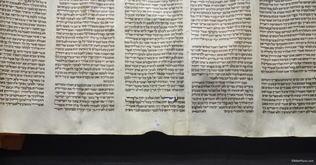
Close-up of Deuteronomy 6:4 in the Trinity Ashkenazi Torah Scroll. Notice the extra large letters which mark the first and last words of the verse. The white patch is newer parchment used to repair the original.

Bethel University received a similar gift earlier in the year (herehere, and here).

UPDATE (December 20, 2015): As of early December 2015, Ken and Barbara Larson have donated Torah scrolls to 16 schools. The list below is as complete as I could make it, but it is missing two schools.

  1. Bethel University (March 31, 2014)
  2. Multnomah University (September 4, 2014)
  3. Trinity Evangelical Divinity School (September 18, 2014)
  4. The Master’s Seminary (September 30, 2014)
  5. Veritas Evangelical Seminary (November 8, 2014)
  6. Wheaton College (November 18, 2014)
  7. Southwestern Baptist Theological Seminary (December 3, 2014)
  8. Dallas Theological Seminary (December 5, 2014)
  9. Trinity Western University (February 2, 2015)
  10. Western Seminary, Portland (February 6, 2015)
  11. Denver Seminary (April 20, 2015)
  12. Liberty University School of Divinity (September 28, 2015)
  13. Baptist Missionary Association Theological Seminary – Arkansas (October 30, 2015; the announcement said BMATS was the 15th school to receive a Torah scroll)
  14. Moody Bible Institute (December 2, 2015; the announcement said 15 other schools had received Torah scrolls)
Share:
(Post by A.D. Riddle)


The “Roads of Arabia” exhibition ends its U.S. tour on January 18, 2015, at the Asian Art Museum in San Francisco. The website does not indicate any further venues for the exhibition, so this might be the last chance to see it. Here are some of our posts about it on this blog (from most recent to earliest):

Roads of Arabia Volume in PDF (July 02, 2014) [The pdf is still available as far as we can tell]
Roads of Arabia Exhibition (June 24, 2014)
Roads of Arabia in Houston (January 08, 2014)
Roads of Arabia Exhibition: Update (April 23, 2013)
Museums and Cultural Heritage (April 05, 2011)
Archaeology of Saudi Arabia (February 27, 2011)

The official website of the “Roads of Arabia” exhibition is online here. I did not notice before that the site has a downloadable “Roads of Arabia Bibliography” at the bottom of this page (direct link). This looks like a helpful resource to have on hand. The first two items of the bibliography are exhibition catalogs. The first of these can be downloaded at the link given above. The second one looks very similar to the first catalog, but it is not exactly the same. Poking around online, I was able to locate a few of the individual chapters. These appear to have better quality images than the full-volume pdf.

The Nelson-Atkins Museum of Art also has a downloadable bibliography related to the exhibition. 
Share: