fbpx
 
An interesting way to study or teach the scriptures is to take a site or geographic feature and collect all the verses that refer to that location.  Such a diachronic study reveals connections that aren’t otherwise readily apparent.  An excellent example of this is the Euphrates River which is mentioned in both Genesis and Revelation, as well as other places in the Bible.

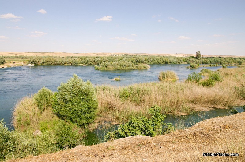
This week’s photo comes from Volume 9 of the revised and expanded edition of the Pictorial Library of Bible Lands, which focuses on Eastern and Central Turkey. The photo was taken by A.D. Riddle and is entitled “Euphrates River North of Carchemish View East” (photo ID #: adr1005191623).

In addition to our picture of the week, I would also like to highlight the valuable annotations that come with the PLBL collection.  The collection is not just a group of high resolution photos.  It also includes Microsoft® PowerPoint® files with excellent notes providing valuable information about the sites and images.  Over the years, I’ve found these notes to be a helpful, quick reference when I’m studying a certain site.  Often these notes will include a brief biblical survey of a particular location.  For example, the following information is provided in the PowerPoint® file on the Euphrates River:

The Euphrates River figures prominently in Scripture, being mentioned dozens of times from its first reference in Genesis 2:14 to the last reference in Revelation 16:12. The source of the river is in the mountains of Armenia northwest of Lake Van at an elevation of more than 10,790 feet (3,290 m). The river then flows through the modern countries of Turkey, Syria, and Iraq before merging with the Tigris River and emptying into the Persian Gulf, traveling a total distance of about 2,000 miles (3,200 km).
 

The Euphrates River in the Bible
1.   The Euphrates River is one of four that flowed from the Garden of Eden (Gen 2:14).
2.   The Lord promised to give Abraham the land between the Euphrates River and the river of Egypt (Gen 15:18; cf. Deut 1:7; 11:24; Josh 1:4; 24:2).
3.   Jacob fled from Laban across the Euphrates River (Gen 31:21).
4.   King David built a monument along the Euphrates River (2 Sam 8:3; 1 Chr 18:3).
5.   Solomon ruled over all the kingdoms as far north as the Euphrates River (1 Kgs 4:21, 24; 2 Chr 9:26; cf. Ps 72:8).
6.   The Lord promised to bring an invader from the other side of the Euphrates River (Isa 7:20; 8:7), but also to bring them back from exile from beyond the Euphrates River (Isa 11:15) and restore their dominion over the land “from the River to the ends of the earth” (Zech 9:10, LEB).
7.   Jeremiah accused the Israelites of faithlessness to the Lord by asking why they went to “drink the waters of the Euphrates” (Jer 2:18, LEB).
8.   The sixth angel will pour out his bowl on the Euphrates, causing it to dry up and allow passage of the enemy kings to attack Israel (Rev 16:12).

As you can see from the numerous verses listed above, a study of the Euphrates River takes you on a journey from Genesis to Revelation.  Along the way, you encounter Abraham, Jacob, David, Solomon, Isaiah, Jeremiah and others.  A study of this one geographic feature provides a platform for you to review (or have your students review) the entire arc of the biblical story, and it can provide a creative way for you to test your students’ knowledge of the Bible.  Try this as an essay question or an ice breaker in your next OT survey class:

“The Euphrates River is mentioned in Gen. 2:14, Gen. 15:18, Gen. 31:21, 2 Sam. 8:3, 1 Kgs. 4:21, Isa. 7:20, Jer. 2:18, and Rev. 16:12.  What is the biblical period and approximate date of each of these references?”

If a student can answer that question, then they know their stuff.  Most likely, you could drop them anywhere in the Bible and they will have their bearings.

This and other photos of the Euphrates River are included in Volume 9 of the Pictorial Library of Bible Lands and can be purchased here.
Share:

(Post by Seth M. Rodriquez)

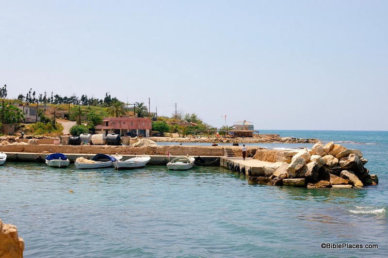
“What do you know about the biblical city of Zarephath?  Where is it mentioned in the Bible?  What biblical events happened there?”  It is a well-known fact that while teaching or preaching, it is helpful to start your dialogue by asking questions that will gain the attention of your listeners.  In addition, in today’s day and age where so much of people’s intake of information is visual, this technique can be even more effective if it is coupled with a picture, such as this one:

Although the photo and the name of Zarephath may not be familiar to most people (even people who are familiar with the Bible), the significance of the place will become evident to your listeners when you connect it with the biblical references to this place.  In other words, it becomes a springboard to an important biblical story.

This week’s photo comes from Volume 8 of the revised and expanded edition of the Pictorial Library of Bible Lands, which focuses on Lebanon. The photo is entitled “Zarephath, Phoenician Harbor and Tell from East” (photo ID #: adr090508617).  Volume 8 is part of the “expanded” features of the PLBL.  It is a completely new volume featuring the pictures of A.D. Riddle, a frequent contributor to this blog.

So where is Zarephath and what is its biblical significance?  Zarephath is an ancient city on the coast of Phoenicia, about 8 miles (13 km) south of Sidon and 14 miles (22 km) north of Tyre.  In antiquity, it had a long and productive existence: it was inhabited from the Late Bronze Period (1600 BC) through the Byzantine Period (AD 600), so it was standing in both Old Testament and New Testament times.  There is also a modern village about a mile from the site today.  Naturally the name of the town changed over the years and as you moved from one culture to another: it was referred to as “Zarephath” by the Israelites, “Sarpu’uta” by the Egyptians, “Sariiptu” by the Assyrians, “Sarepta” by those in Hellenistic and Roman times, and “Sarafand” today.

Zarephath occurs in two chapters in the Bible: 1 Kings 17 and Luke 4.  In the book of 1 Kings, Zarephath is the town where the Lord instructed Elijah to go during the last part of the three-year of drought in Israel.

Then the word of the Lord came to him, “Arise, go to Zarephath, which belongs to Sidon, and dwell there. Behold, I have commanded a widow there to feed you.” (1 Kgs. 17:8-9, ESV)

While he was there, the Lord provided for Elijah, the widow, and her son in a miraculous fashion.  This was followed by another miracle when the widow’s son died and the prophet raised him back to life.

The drought ended in the next chapter, 1 Kings 18, after Elijah confronted the prophets of Baal on the top of Mount Carmel.  In a way, the events in Zarephath were a subtle precursor to the dramatic confrontation in 1 Kings 18.  Zarephath was in the territory of Sidon, the homeland of Queen Jezebel and a region where Baal was worshipped.  In fact, Jezebel was the one responsible for making Baal worship the official state religion in Israel after she married King Ahab, as 1 King 21:25-26 makes clear.  In light of all this, Elijah’s words to the widow in chapter 17 are significant:

For thus says the Lord, the God of Israel, “The jar of flour shall not be spent, and the jug of oil shall not be empty, until the day that the Lord sends rain upon the earth.” (1 Kgs. 17:14, ESV, emphasis added)

This was a bold claim in the territory of Baal-worshippers: the God of the Israelites will perform a miracle on your behalf, not the god of the Sidonians.  The widow herself seems to have already had faith in the God of Israel (1 Kgs. 17:12), but when 1 Kings 17 is studied in context with 1 Kings 18 the theme seems to be that God is mightier than the false god Baal.

Finally, in Luke 4:24-26, Jesus references these events while discussing the fact that a prophet has no honor in his hometown.  Jesus was almost stoned after saying this, probably because he used examples where Israelite prophets were used as a means of blessings to Gentiles … a truth that was not very palatable in 1st century Galilee.

This and other photos of the Zarephath are included in Volume 8 of the Pictorial Library of Bible Lands and can be purchased here. More information and photos about Zarephath can be found on the BiblePlaces website here.
Share:

(Post by Seth M. Rodriquez)

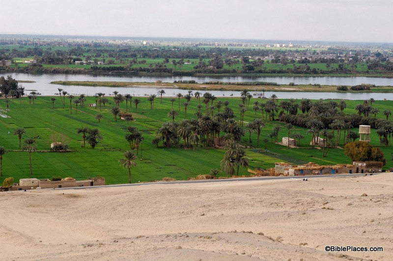
As I’ve pointed out before in this series, pictures can be powerful tools in the hands of the Bible teacher.  The right picture can illuminate a passage and bring deeper understanding.  This week’s photo is another example.  It comes from Volume 7 of the revised and expanded edition of the Pictorial Library of Bible Lands, which focuses on Egypt.  The photo is entitled “Nile River Valley Near Beni Hasan Tombs from East” (photo ID #: tb010805121).

When the Israelites were about to enter the Promised Land, Moses contrasted the land of Egypt with the land of Canaan:

For the land, into which you are entering to possess it, is not like the land of Egypt from which you came, where you used to sow your seed and water it with your foot like a vegetable garden. But the land into which you are about to cross to possess it, a land of hills and valleys, drinks water from the rain of heaven, a land for which the Lord your God cares; the eyes of the Lord your God are always on it, from the beginning even to the end of the year. (Deut. 11:10-12, NASB)

In the context of the chapter, Moses is warning the people to obey God’s commandments so that they will prosper in the land.  He explains that life in the Promised Land will be very different than it was in Egypt, and this week’s photo helps explain why.

The agriculture of Egypt is based on the water from the Nile.  Farmers plant their crops in the flat land around the Nile, in part, because they have easy access to water from there.  The phrase in verse 10 “sow your seed and water it with your foot” has produced a number of interpretations, such as carrying the water by foot in buckets, digging channels with one’s feet, and using a mechanical device that is powered by foot.  Whatever the correct interpretation, the point is that in Egypt it was possible to provide water for your crops by mere manpower.  In this week’s photo, you can see the relationship between the farmland and the Nile, and it is clear from this picture that it would be a relatively easy task to get water from the Nile to the crops growing nearby.

By contrast, the agriculture of Canaan is vastly different.  There is no convenient and reliable natural source of water for the farmer’s crops.  In contrast to the flat farmlands that surround the Nile, Canaan is “a land of hills and valleys,” which makes moving water from one place to another difficult.  And the only major river that flows through the land, the Jordan, is below sea level for most of its course and is basically useless for irrigation.  Before the advent of modern machinery, the only way the fields could be watered was by rain.

 
So in Deuteronomy 11, Moses warns the people that they must obey God to thrive in the Promised Land.  If they obey, then God will send the rain and they will have food (Deut. 11:13-15).  If they don’t, then:
 

He will shut up the heavens so that there will be no rain and the ground will not yield its fruit; and you will perish quickly from the good land which the Lord is giving you. (Deut. 11:17, NASB)


The land to which God was leading His people was a land that required them to walk by faith and depend on Him.
 
This and other photos of the Nile Valley are included in Volume 7 of the Pictorial Library of Bible Lands and can be purchased here. More information and photos about the Nile River can be found on the BiblePlaces website here.  For more thoughts on how the Land of Israel was a land that fostered faith, see my post here.
Share:

(Post by Seth M. Rodriquez)

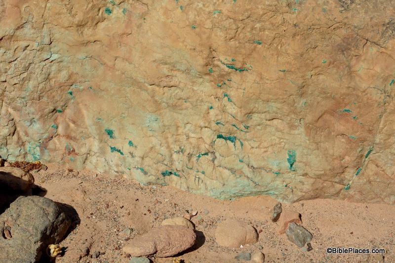
This week’s photo comes from Volume 6 of the revised and expanded edition of the Pictorial Library of Bible Lands, which provides a collection of pictures from the country of Jordan.  In my introduction to this series, I promised to highlight “the more unusual pictures that illustrate a particular feature of geography or archaeology that can be easily overlooked or that other photo collections fail to include.”  So this week’s picture is not a stunning photo of the ruins of Petra or the amazing Roman city of Gerasa or even the biblically significant Mount Nebo and Plains of Moab (although the new edition of the PLBL has new photos of each of those places).  Instead, this week’s photo was taken south of the Dead Sea in Wadi Jariya and focuses on a small section of bedrock.  It is entitled “Wadi Jariya Exposed Copper Ore in Bedrock” (photo ID #: df070807104) and was taken by Dr. Daniel Frese.  (Click on the photo for a higher resolution.)

You will never see this picture framed in a Sunday School classroom or hanging over someone’s mantelpiece, but it can go a long way in illuminating Deuteronomy 8:9 and is useful when explaining the process of ancient copper mining.

Deuteronomy 8:9 states that copper could be dug “out of the hills” in the land of Canaan.  Although Wadi Jariya lies within the territory of Edom and is outside the borders of the Promised Land, the process was similar there.  In the photo, the green specks on the rock are the copper ore.  This ore was chiseled out of the rock and then refined through a smelting process which removed the impurities.  When the impurities cooled, they formed a solid, dark substance called slag.  At various locations in Israel and Jordan (as well as elsewhere in the Middle East) large amounts of slag are left over from antiquity.  In fact at Khirbet en-Nahas, a neighboring site to the Wadi Jariya operation, a slag pile over 20 feet deep has been discovered.

Copper mining was an important element of the ancient economy since copper was used extensively in that society.  Usually the copper was mixed with a little bit of tin and was thus transformed into bronze, a strong metal sometimes used in scripture to refer to someone or something hard or stubborn (Deut. 28:23; Jer. 1:18; 6:28).  Bronze was used to make many things in biblical times, such as utensils (Exod. 38:3), weapons (1 Sam. 17:6), chains (2 Kgs. 25:7), and cymbals (1 Chr. 15:19) to name a few.  Its value is seen in the fact that it was listed among the spoils of war along with gold, silver and iron (Josh. 6:19, 24).  But its humble beginnings can be traced back to this picture … as a green speck within a hard rock found in a dry valley.

This and other photos related to copper mining are included in Volume 6 of the Pictorial Library of Bible Lands and can be purchased here.  More information and photos about copper mining can be found on the BiblePlaces website here.
Share:

(Post by Seth M. Rodriquez)


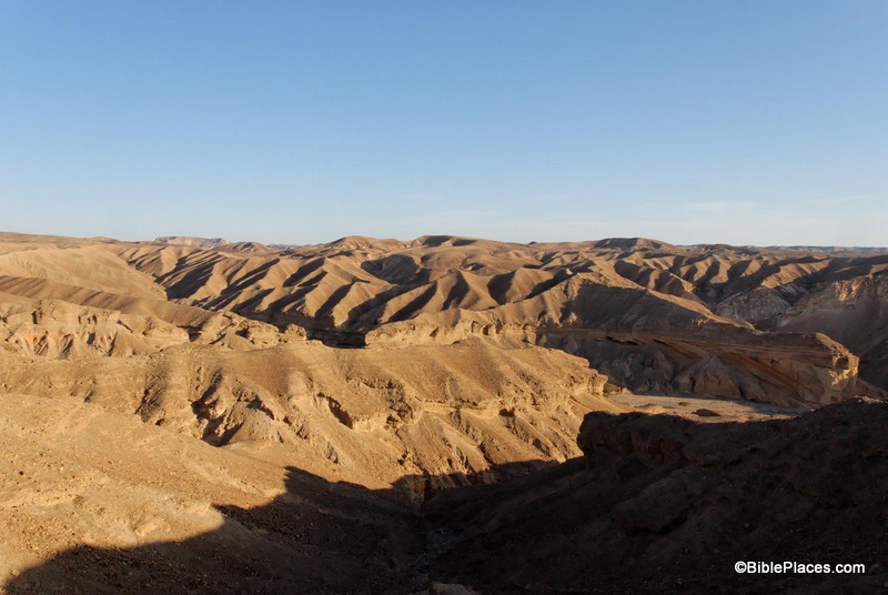
This week’s photo comes from Volume 5 of the revised and expanded edition of the Pictorial Library of Bible Lands and is entitled “Wilderness of Paran” (photo ID #: tb042007570).

The Wilderness of Paran is a desert region northwest of the Gulf of Aqaba that today straddles the southern end of the State of Israel and the eastern edge of Egypt.  It appears in the Biblical text as a lonely place outside the Promised Land.  This region is the place where Ishmael and Hagar lived after Abraham sent them away (Gen. 21:20-21).  It is also a place where David sojourned to escape from Saul (1 Sam 25:1), and a place that Hadad the Edomite passed through while he and some other Edomites were fleeing from David and Joab (1 Kgs. 11:14-19).  It is apparent from these passages that this region often served as a safe haven for people who were cast out or were fleeing from danger.

The Wilderness of Paran is also where Israel spent part of their time during the Wilderness Wanderings (Num. 10:12; 12:16).  In fact, this is the fateful area where God’s judgment fell on the people.  While they were encamped here, they sent the twelve spies into the land of Canaan and when ten of the spies brought back a bad report, the people rebelled against the Lord and refused to go into the land (Num. 13:2-3, 26).  Consequently, that generation was doomed to die in the wilderness because they failed to trust in God and obey him.  A photo such as this can enhance the retelling of that key chapter in Israel’s history.

This photo is included in Volume 5 of the Pictorial Library of Bible Lands and can be purchased here.  More information about the Wilderness of Paran can be found on the BiblePlaces website here.
Share:

(Post by Seth M. Rodriquez)

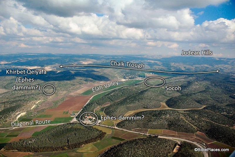
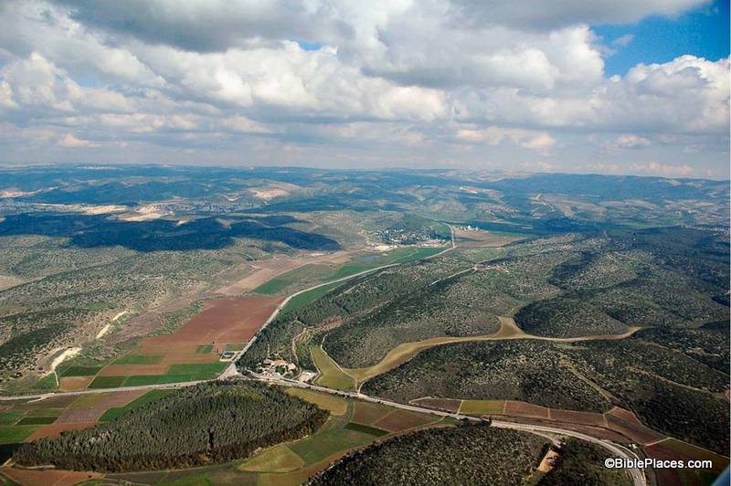
This week’s photo comes from Volume 4 of the revised and expanded edition of the Pictorial Library of Bible Lands and is entitled “Elah Valley Aerial from West” (photo ID #: tb011606772).  One of the improvements in the new edition of the collection is the addition of some aerial photos of the Elah Valley which make it easy to pick out the valley from among the hills of the Shephelah.  In the photo above, the valley can be seen starting at the bottom left corner, moving diagonally up to the center.  (Click on the photo for a higher resolution.)

This photo is extremely useful when discussing the encounter of David and Goliath.  First Samuel 17 sets the stage in the following way:

Now the Philistines gathered their armies for battle. And they were gathered at Socoh, which belongs to Judah, and encamped between Socoh and Azekah, in Ephes-dammim. And Saul and the men of Israel were gathered, and encamped in the Valley of Elah, and drew up in line of battle against the Philistines. And the Philistines stood on the mountain on the one side, and Israel stood on the mountain on the other side, with a valley between them. (1 Sam. 17:1-3, ESV.)

Most of the locations in this passage are visible in this picture.  To assist in identifying them, I’m going to pull from one of the PowerPoint presentations included in the Pictorial Library collection:

In this slide the location of the Elah Valley and Socoh are clearly marked, along with possible locations of Ephes-dammim.  Azekah is not pictured here, but is located just off the photo to the left.  You can easily imagine the Philistine army on one side of the valley and the Israelites on the other, just as it is described in verse 3.

In the background, the Judean Hills are marked which adds to the value of this photo.  When teaching on David and Goliath, I like to point out to my listeners that there was much at stake for David in this battle.  Not only were the Israelite soldiers facing a deadly enemy and not only was the reputation of Israel’s God on the line, but there was another element that we tend not to think about which relates to geography.  If you look at a map of this area you will see that the Elah Valley is an entryway into the Hill Country of Judah, the region where David and his family lived.  Three thousand years after the fact we have the advantage of knowing how it turned out, but if David had lost the battle it is possible that the Philistines would have penetrated into the Judean Hills (as they had when they were encamped at Michmash on the Central Benjamin Plateau).  This would have put David’s family and neighbors at serious risk.  So as David faced Goliath, he was not only fighting for his people and his God … he also was fighting for the safety of his own hometown.

This photo is included in Volume 4 of the Pictorial Library of Bible Lands and can be purchased here.
Share: