fbpx

(Guest post by Seth M. Rodriquez.)

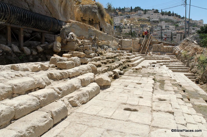
One of the most impressive additions to Volume 3 of the revised and expanded Pictorial Library of Bible Lands are the photos of the newly discovered Pool of Siloam.  The original Pictorial Library was published in 2003 and the 1st century Pool of Siloam was discovered one year later.  So naturally the original collection did not include any pictures of this significant site, but the revised version includes over 30.  So this week’s photo comes from Volume 3 of the revised and expanded edition and is entitled “Pool of Siloam Excavations” (photo ID #: tb070305450).

First, a note of explanation:  If you have ever been to Israel and have walked through Hezekiah’s Tunnel, you were probably told that the small pool at the end of the tunnel was the Pool of Siloam. 

That is true but it should be clarified that that is the Pool of Siloam from the Byzantine period (AD 324-640).  The pool pictured above is the Pool of Siloam that existed in the 1st century AD.  This is a much larger pool than the Byzantine pool.  The side that has been excavated is 160 feet long (50 meters).  There are three groups of steps leading down, with each group containing five steps.  The fifth step of each group is much longer than the others and probably served as a platform for bathers to stand on.

This Pool of Siloam is the one that existed during the time of Jesus and His disciples.  In fact, John 9 tells us that a miraculous healing occurred at this very spot.  As they are leaving the Temple, Jesus and the disciples see a man who has been blind since his birth and the disciples ask Jesus a question that probably was debated by the leading religious minds of their day: “Who sinned, this man or his parents, that he was born blind?” (John 9:2, ESV.)  The question gives Jesus the opportunity to teach them an important lesson that corrected their thinking and now serves as a comfort for all who have ever wrestled with incurable physical ailments: “It was not that this man sinned, or his parents, but that the works of God might be displayed in him.” (John 9:3, ESV.)  Then Jesus made some mud by spitting on the ground, placed it on the man’s eyes, and told him to wash in the very pool pictured above: “Go, wash in the pool of Siloam” (John 9:7, ESV).  The man followed Jesus’ command and could see after he washed the mud off his eyes.

Unfortunately only part of the pool has been excavated.  The rest of it sits under an orchard that the owners are not willing to remove (the last I’ve heard).  Hopefully that situation will change in the near future so that more of this important pool can be exposed.

Additional photos and more information about the newly discovered Pool of Siloam are available here and here on the BiblePlaces website.  Previous posts on this blog about the pool (which are numerous) can be found here.  This photo, along with over 30 other pictures of the pool, is included in Volume 3 of the Pictorial Library of Bible Lands and can be purchased here.
Share:

 (Guest post by Seth M. Rodriquez. For an introduction to this series, see last week’s post.)

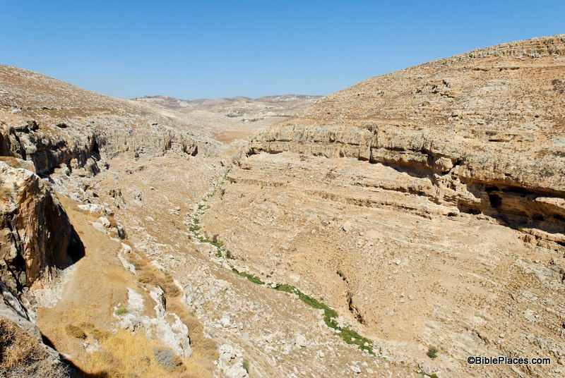
This week’s photo comes from Volume 2 of the revised and expanded edition of the Pictorial Library of Bible Lands.  It is entitled “Cliffs Near Michmash and Geba from Southeast” (photo ID #: tb092706140).  However, the name of the picture does not do justice to the thrilling events that took place here in the time of King Saul.

First Samuel 13 tells us that shortly after Saul was crowned king, the Philistines had penetrated deep into Israelite territory.  Normally the Philistines controlled only the coastal plains, but at this point in history they were attempting to gain control over the hill country as well.  They were encamped at Michmash in the territory of Benjamin, in the heart of Israelite territory (1 Sam 13:5).  Saul mustered his troops but suffered a defeat (1 Sam 13:6-7).  He was in dire straits and his character was put to the test as he waited for Samuel to arrive and offer sacrifice on behalf of the troops (1 Sam 13:8).  Saul cracked  under the strain and offered the sacrifice himself, incurring God’s judgment (1 Sam 13:9-15).  This chain of events only made matters worse and the Philistine army started spreading out from Michmash, gaining control over the heart of Saul’s kingdom (1 Sam 13:16-18).

This was the situation that Jonathan found himself in, yet unlike his father his character blossomed under such difficult circumstances.  First Samuel 14 provides us with the story.  The picture above shows the cliffs that separated the Philistine camp at Michmash and the Israelite camp at Geba.  The modern name for this valley is the Wadi Suweinit.  The cliffs on the left side of the photo led to Geba and the cliffs on the right to Michmash.  The Bible refers to these cliffs in this way:

“Within the passes, by which Jonathan sought to go over to the Philistine garrison, there was a rocky crag on the one side and a rocky crag on the other side. The name of the one was Bozez, and the name of the other Seneh. The one crag rose on the north in front of Michmash, and the other on the south in front of Geba.” (1 Sam. 14:4-5, ESV.)

The camps were only about a mile apart.  There is a pass between the two sites at the head of the valley (near the top center of the photo) where the main road was and still is today.  That strategic pass through the area was probably the reason the Philistine soldiers chose to camp at Michmash: if they camped close by, they could monitor and control the traffic through the pass.

However, instead of approaching the Philistine garrison on the main road through the pass, Jonathan decided to surprise the Philistines by scaling the cliffs.  Verse 13 tells us that Jonathan climbed up to the Philistine camp “on his hands and his feet.”  Amazingly, he takes only his equipment bearer with him: two soldiers against an entire garrison.  His reasoning for the attack is a testimony to his great faith:

“Come, let us go over to the garrison of these uncircumcised.  It may be that the Lord will work for us, for nothing can hinder the Lord from saving by many or by few.” (1 Sam 14:6, ESV.)

In the end, God rewarded Jonathan’s faith by giving him the victory.  He and his equipment bearer killed 20 soldiers and the rest were thrown into a panic (1 Sam 14:14-15), which provided the Israelites with an opportunity to win a great victory.  (You can read the rest of the story here.)  Many things have changed in the land of Saul and Jonathan over the last 3,000 years, but these cliffs still stand today as a silent witness of the faith and heroic deeds of Jonathan.

This photo is included in Volume 2, “Samaria and the Center” of the Pictorial Library of Bible Lands can be purchased here.
For more on Michmash, Geba and the pass, go here.

Share:

(Post by Seth M. Rodriquez)

With the recent release of the revised and expanded version of the Pictorial Library of Bible Lands, I thought it would be helpful to start a series of posts that highlight some pictures from the collection. 

With over 17,000 pictures in 18 volumes, there is an immense amount of material in there.  My purpose will be to feature one photo per week that can be especially useful in the classroom or in the church.  Although the PLBL collection contains many of the typical “postcard” shots of the usual tourist locations, its true value lies in the more unusual pictures that illustrate a particular feature of geography or archaeology that can be easily overlooked or that other photo collections fail to include.  It is these types of pictures that I would like to highlight and discuss.  Preference will be given to photos that were not included in the original edition of the Pictorial Library and that are not posted on the BiblePlaces.com website.

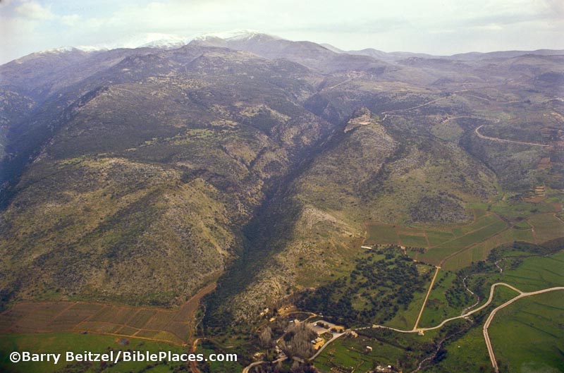
Our first photo comes from Volume 1: Galilee and the North, and is entitled “Mount Hermon and Caesarea Philippi aerial” (photo ID #: bb00140015).

Mount Hermon and Caesarea Philippi aerial

In this photo, the immense size of Mount Hermon can be clearly seen while it dwarfs the remains of the ancient city of Caesarea Philippi (located at the bottom center of the photo).  The ruins of the Crusader period castle of Nimrud can also be seen sitting on the ridge above Caesarea Philippi in the upper right quadrant of the photo.

This shot is helpful for a number of reasons.  First, it gives the viewer an appreciation for the massive size of Mount Hermon.  With its peak reaching an altitude of 9,230 feet (2,814 meters), it is almost three times the height of any other peak in the territory of ancient Israel.  Secondly, it shows the geographical relation between the castle of Nimrud and Caesarea Philippi.  Although I have visited both sites a number of times, the fact that they were both built on the same ridge escaped my notice until I saw this picture.  However, those two reasons are not why I decided to feature this picture in today’s post.

The third and most valuable reason is that it can be used effectively as an illustration when teaching or preaching on the Transfiguration of Jesus.  The Transfiguration occurs in Matthew 16:28-17:9, Mark 9:1-9, and Luke 9:27-36.  In each of those books, the event is immediately preceded by the discussion that Jesus had with his disciples where Peter declared, “You are the Christ, the Son of the Living God.”  Matthew and Mark tell us that this conversation occurred in the region (or district) of Caesarea Philippi (Matt. 16:13; Mark 8:27). 

A few days later, Jesus took Peter, James, and John up on a mountain where He was transformed in front of them.  Matthew and Mark describe the location as “a high mountain” (Matt. 17:1; Mark 9:2), and Luke refers to it as “the mountain” with a definite article (Luke 9:28).  Looking at this photograph it is not hard to see which mountain the gospel writers had in mind.  If they were in the region of Caesarea Philippi and they went up a high mountain … indeed the most noteworthy mountain in the area … then it is not difficult to figure out which mountain was intended.  Over the years, some have interpreted the “mountain” in these passages as referring to Mount Tabor on the eastern edge of the Jezreel Valley, but given the geographical indicators provided in the text, Mount Hermon is a more likely candidate.

For a teacher or preacher, a photo such as this could be used as a dramatic backdrop to a discussion of the pivotal conversation Jesus had with His disciples in this region and the Transfiguration on the mountain.  By looking at this photo, the listener can easily picture the entire chain of events: the private conversation somewhere down in the valley, the physical exertion of Jesus and the chosen three as they climb the tall mountain, the glorious transformation of Jesus appearing as a bright spot somewhere on the mountain as His face and clothes shone brightly (Matt. 17:2), and finally the appearance of a shining cloud as God the Father spoke to the disciples (Matt. 17:5).  The use of a photo such as this can draw students and congregations into the story and engage their minds in a way that cannot be done with words alone.  The picture enhances the message.

This photo is included in Volume 1 of the Pictorial Library of Bible Lands and can be purchased here.
Share:

Being able to clearly see what lies underground would solve many headaches for archaeologists.

There is a certain level of guesswork that goes into planning a dig, and only after the available time, money, and manpower has been spent does it become clear whether or not it was worth the investment. However, a professor at Tel Aviv University has developed a new tool that potentially could offer some help in taking the guesswork out of deciding where to dig.

Reported recently in the journal Advances of Geosciences, Prof. Eppelbaum’s new tool gathers data from a number of sources — including radio transmitters used to communicate with nuclear submarines and detailed magnetic field observations — and applies an original algorithmic approach to the measurements to make sense of what lies below the earth’s surface at depths of up to several dozen yards. His tool can help people “see” meaningful objects, artefacts or civilizations — – and lay them out in a four-dimensional chart.

While methods exist for scanning sites of potential archaeological and geological importance, such tools produce significant background noise or inconclusive readings, Prof. Eppelbaum says. …

His tool can be used to evaluate the possible archaeological significance of any given area under scrutiny. Providing rapid results within days or even hours, the algorithm can “read” extensive data before any digging or exploration begins. Financially, technically and ecologically, this tool offers an optimal way to localize and classify ancient buried objects and estimate the potential of the further archaeological investigations, he says.

Prof. Eppelbaum’s solution is called the “multi-PAM,” which stands for “physical — archaeological models.” The tool first interprets what it “sees” by recognizing image targets; then the interpretation can be used to develop a four-dimensional model which can be presented to archaeologists hoping to explore a particular region.

Placed in a small unmanned airplane hovering several yards off the ground and scanning wide tracts of land along the earth’s surface, Prof. Eppelbaum says, the tool can reveal unexplored sites of historical and archaeological significance.

You can read the full post here. A shorter article can be found here.

According to one of the posts, this tool is already in use in some archaeological projects. Does anyone have any personal experience with one? Would you care to share your opinion?

Update:
The catalyst for this news event apparently was a post on the website of the American Friends of Tel Aviv University. This post looks back at the publication of a paper that Prof. Eppelbaum presented in April 2009. The paper is titled: “Archaeological geophysics in Israel: past, present and future.” This paper (along with several others on similar topics) was published in the open access journal called Advances in Geosciences (ADGEO) in 2010. The abstract of Eppelbaum’s paper and a link to download the article can be found here. A list of all the articles in that volume can be found here. For those who desire to learn more about modern techniques for non-intrusive archaeological investigation, this volume is a good place to start.

HT: Joseph I. Lauer

Share:

On Sunday, The New York Times posted an article about the meaning of the Hebrew word tekhelet, mentioned in Exodus 26:1 and elsewhere in the Hebrew Bible. Instead of light blue, Zvi C. Koren argues that is was a “closer to a bluish purple.”

On Tuesday, The Hebrew University of Jerusalem posted a press release about the publication of the first volume of The Corpus Inscriptionum Iudaeae/Palestine (CIIP) series. There are 9 volumes of the series scheduled and the goal is to collect “all the inscriptions ever found in Israel and the Palestinian Authority from the period of Alexander the Great (4th century C.E) until Mohammed (beginning of the 7th century A.D.)” The first volume “includes more than 700 inscriptions from Jerusalem and surrounding areas up until the destruction of the Second Temple.”

Also on Tuesday, reports about a break in at an artifact storehouse near the Giza pyramids were posted here and here.

On Wednesday, Aren Maeir posted on his blog a summary and a critique of recent lectures at Hebrew University about the Philistines and Sea Peoples.

Also on Wednesday, an article about archaeology in Libya (in light of the current unrest in that country) was posted by Scientific American here.

On Thursday (as was previously posted on this blog) Zahi Hawass announced that he will step down. Reports of this event can be found here and here. Hawass also posted a report on his blog that day about the dangers that are threatening archaeological sites and artifacts in Egypt. Biblical Archaeology Review intends to publish an interview with Hawass in the next issue.

Also on Thursday, Israel National News posted an article on a new training program being offered by the Israel Antiquities Authority. It is “a program to teach Jews from around the world how to conserve ancient buildings. The program, called Saving the Stones, is a five-month international training internship in historical and archeological conservation.” The IAA’s press release is here.

On Friday, a new exhibit with body casts from Pompeii opened at Discovery Times Square. The exhibit website is here and an article about it in the New York Times is here.

The McMullen Museum of Art at Boston College is currently displaying a collection called Dura-Europos: Crossroads of Antiquity. Admission to the museum is free.

HT: Jack Sasson, Joseph I. Lauer, A.D. Riddle

Share:

Let me start by saying that you do not need an Amazon Kindle to read Kindle books. Amazon offers free reading apps for iPads, iPhones, PCs, Macs, Androids, BlackBerries and Windows Phones, so you can read Kindle books on any of those devices. Personally I recently entered the world of Kindle by purchasing a Kindle Wi-Fi, and I would recommend the device to anyone who enjoys reading.

(There is also a 3G version and a version with a 9.7″ display.) But you don’t need to spend $139 or more to get the books referenced below. They are available absolutely free through the use of one of the free reading apps.

One of the things that attracted me to the Kindle was all of the free books that are available in Kindle form. Amazon advertises: “Over 1.8 million free, out-of-copyright, pre-1923 books are available.” Many of these books are “Popular Classics” such as The Adventures of Sherlock Holmes, Pride and Prejudice, and Alice’s Adventures in Wonderland. However, some of the free books are out of copyright works related to archaeology and ancient history that I think would be of interest to readers of this blog. Here are the works that I have found so far that fit this category:

  • Flavius Josephus, Against Apion, translated by William Whiston, (c) not listed.

Let me also point out that this is not an exhaustive list. In addition to the fact that there are probably other books available on Amazon’s website that I missed, works from the Internet Archive, Open Library, Project Gutenberg, and ManyBooks.net can be delivered to your Kindle or Kindle App as well. More information on how to do that can be found here. Also, I did not include books that are available for very little money through the Kindle Store. Perhaps we’ll explore those titles at a later date.

Disclaimer: Please keep in mind that these books are free, and to some degree “you get what you pay for.” So don’t expect too much. For example, in many (if not all) cases, the illustrations that were included in the original book are not included in the free Kindle book. At the same time, if I had to choose between having a free Kindle version of a book and not having the book at all, I would choose the Kindle book. After all, if I find that the work is particularly valuable, I can always track down a physical copy of the book to use in serious research or a writing project. In that sense, these free books serve as a great introduction to some of the classic works on Middle Eastern archaeology and ancient history.

Also (although it is not exactly free) I should mention that there is a subscription available to the BiblePlaces Blog through the Kindle store for 99 cents a month. Unlike an RSS feed which only sends a stub about new posts, this subscription service delivers new posts in their entirety. The first 14 days of service are free, if you would like to try it out.

Anyone else know of any free books that would be of interest?

Share: