fbpx

(Post by Seth M. Rodriquez)

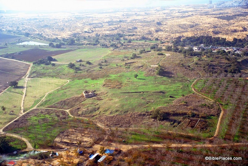
Our picture of the week is an “elephant in the room,” archaeologically speaking. This site was occupied by Israel’s most notorious neighbor, was a flourishing city 100 acres in size, and was once a resting place of the Ark of the Covenant. Yet this site is hardly (if ever) visited by tourists in Israel today. Thus, we continue our series of “obscure sites” with a map and photograph of the Philistine city of Ashdod.


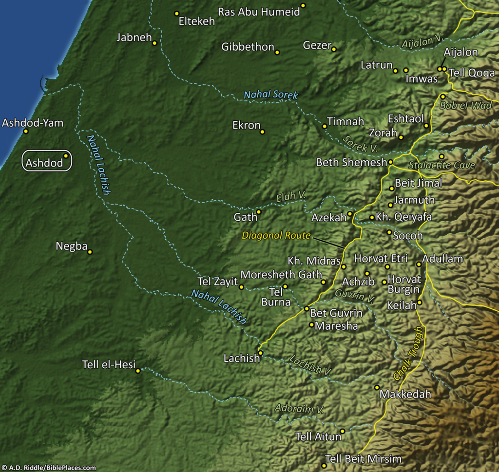
Ashdod is located only 3 miles (4 km) from the Mediterranean coast. In ancient times it possessed some prime real estate along the main international highway that passed through the Levant, which helped contribute to the city’s wealth and prominence. In the map below (included in the PowerPoint files in Volume 4 of the PLBL), Ashdod can be seen in the far left. (Click on the image to enlarge it.)


The site was excavated for nine seasons in the 1960s and 70s. Remains from the Middle Bronze period to the Byzantine period were found here. At its largest size, the site was comprised of an upper city of at least 20 acres and a lower city of at least 70 acres.

The city reached this peak size during the time of the Philistines, when it was one of the five major cities of Philistine coastal plain (along with Ekron, Gath, Ashkelon, and Gaza). Amihai Mazar summarizes the archaeological findings at Ashdod from this period in the following way:

At Ashdod the first Philistines settlement (Stratum XIII), although unfortified, was a well-planned and densely built city, some twenty acres in area. … The next two levels at Ashdod (Strata XII-XI) denote successive rebuildings of the Philistine city in the twelfth and eleventh centuries B.C.E. In Stratum XII the ruined fortifications of the last LB II city (Stratum XIV) served as foundations of a solid city wall. At the end of the eleventh century B.C.E. (Stratum X), Ashdod expanded to a size of about 100 acres, thus becoming one of the largest cities in the country. In this time Ashdod was surrounded by a solid wall with a four-chamber gate. This enlarged city endured for a long time in Iron II.

During this period is when the Ark of the Covenant was captured by the Philistines in a battle against the Israelites (1 Sam. 4:1-11). The Ark was carried back to Ashdod and set in the temple of the Philistine god Dagon. As the story unfolds in 1 Samuel 5, this turn of events did not bode well for the statue of Dagon. It was supernaturally knocked down twice and consequently had its head and hands broken off. Furthermore, the people of the city were struck with a plague of tumors. So eventually the people of Ashdod sent the Ark to the neighboring city of Gath, where it wreaked further havoc on the Philistines.

The city of Ashdod also appears in several other places in the Old Testament. It is noted in the book of Joshua that it was not conquered by the Israelites when they entered the land of Canaan (Josh. 13:1-3), but several hundred years later it was conquered by King Uzziah of Judah (2 Chr. 26:6-7) and then by the Assyrians (Isa. 20:1-2). The city also is mentioned (and targeted!) in a number of prophesies in the Old Testament (Amos 1:8; 3:9; Isa. 20:1-2; Jer. 25:20; Zeph. 2:4; Zech. 9:6). Finally, in the book of Nehemiah the people of Ashdod opposed the rebuilding of the wall in Jerusalem (Neh. 4:6-8) and intermarried with some of the Judeans (Neh. 13:23-27).

Although this site has an immense significance both biblically and archaeologically, it is not currently set up to host tourists. When I visited the site in 2006, I was on my own in a borrowed car. I had to park and walk through an orchard to get to the site. Nothing was marked and I couldn’t even get to the top of the acropolis. The tell is bordered by industrial buildings and there is nothing there to indicate that this was once the thriving Philistine metropolis of Ashdod. And so, this once important city sadly finds itself among the “obscure sites” of the Holy Land.

This photo and over 1,500 others can be found in Volume 4 of the Pictorial Library of the Holy Land and can be purchased here for only $39 (with free shipping). Additional pictures and information about other Philistine cities can be found on the BiblePlaces website here and here, and on the LifeintheHolyLand website here.

The excerpt above is taken from Amihai Mazar, Archaeology of the Land of the Bible: 10,000-586 B.C.E., The Anchor Bible Reference Library (New York: Doubleday, 1990), p. 308, which is available for purchase here.

Post Script:  For those of you who may be interested, I have posted a review of the Rose Then & Now Bible Map Atlas on my personal blog here. Specifically, the review focuses on the electronic version published by Logos Bible Software.
Share:

(Post by Seth M. Rodriquez)

Our series on “Obscure Sites in the PLBL” hit a little snag this week as I turned to Volume 3 which focuses on Jerusalem. How do you pick an “obscure site” in a place as famous and as familiar as Jerusalem?  The solution is to go underground …

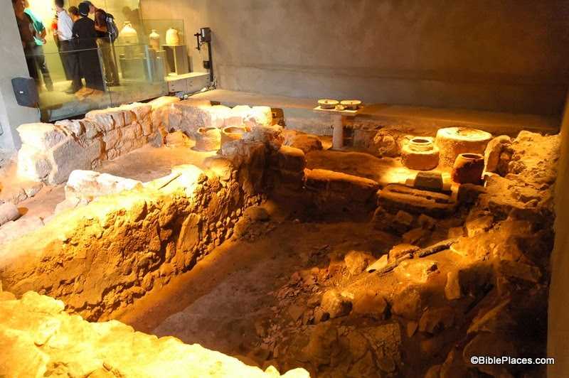
Our obscure site for this week is The Burnt House in the Jewish Quarter of the Old City of Jerusalem. This place is probably familiar to many readers of this blog, but I don’t think it makes it onto the itinerary of many tours to the Holy Land so it qualifies as “obscure.” This is a site that dates back to the destruction of Jerusalem by the Romans in the first century. In his book, The Holy Land, Jerome Murphy-O’Connor introduces the site in this way:

A month after the destruction of the Temple and the Lower City in early September AD 70, the Romans stormed into the Upper City: ‘when they went in numbers into the lanes of the city, with their swords drawn, they slew without mercy those whom they overtook, and set fire to the houses whither the Jews had fled, and burnt every soul in them’ ([Josephus,]  War 6: 403). This was one of those houses. The latest coin found among the charred debris on the floor was dated AD 69; an unused spear stood in one corner.

One thousand, nine hundred years later, archaeologists working under Nahman Avigad uncovered this house that (presumably) had been destroyed by the Romans. What you see in the picture above is the bottom level of the house. Leen Ritmeyer has posted his reconstruction of the entire house on his blog here, along with some newspaper clippings from the time of its discovery. While discussing this site, Avigad once wrote:

This house was destroyed by an intense fire and was filled with fallen stones, wooden beams (carbonized) and layers of ash. The plastered walls were completely covered with soot, and the debris concealed many artefacts. What is unique here is the fact that the debris had not been cleared away or disturbed by later construction: Everything remained just as it was when the building was destroyed.

Many of these artifacts can be seen in the museum which now sits under the buildings of the modern Jewish Quarter. The most chilling aspect of this discovery was the fact that the archaeologists found the skeletal remains of an arm of a young woman, lying on the threshold of the entrance. Presumably this was one of the victims who died at the hands of the Romans in AD 70.

This photo and over 1,500 others (including pictures of the artifacts on display in The Burnt House Museum) are available in Volume 3 of the Pictorial Library of Bible Lands, and can be purchased here for $39 (with free shipping). If you care to visit the site on your next trip, the Burnt House Museum is located at 2 Hakaraim Street, Jerusalem, near the top of the long staircase that leads down to the Western Wall Plaza.

The first excerpt was taken from Jerome Murphy-O’Connor, The Holy Land: An Oxford Archaeological Guide from Earliest Times to 1700, 4th ed. (Oxford: Oxford University Press, 1998), pp. 73-74.  The 5th edition can be purchased here.


The second excerpt was taken from Nahman Avigad, “Excavations in the Jewish Quarter of the Old City, 1969-1971,” p. 46, in Jerusalem Revealed: Archaeology in the Holy City 1968-1974 (Jerusalem: The Israel Exploration Society, 1975).

Share:

(Post by Seth M. Rodriquez)

What is the most significant, ancient harbor city in Israel that hardly ever gets visited by tourists?

Everyone has heard of Caesarea, but that place is a young sprout compared to this site. Acco and Joppa are potential candidates, but even they get more publicity than this site. Continuing our series of “Obscure Sites in the PLBL” (or “What You Missed on Your Trip to the Holy Land”) we focus this week on the small but significant site of Dor.

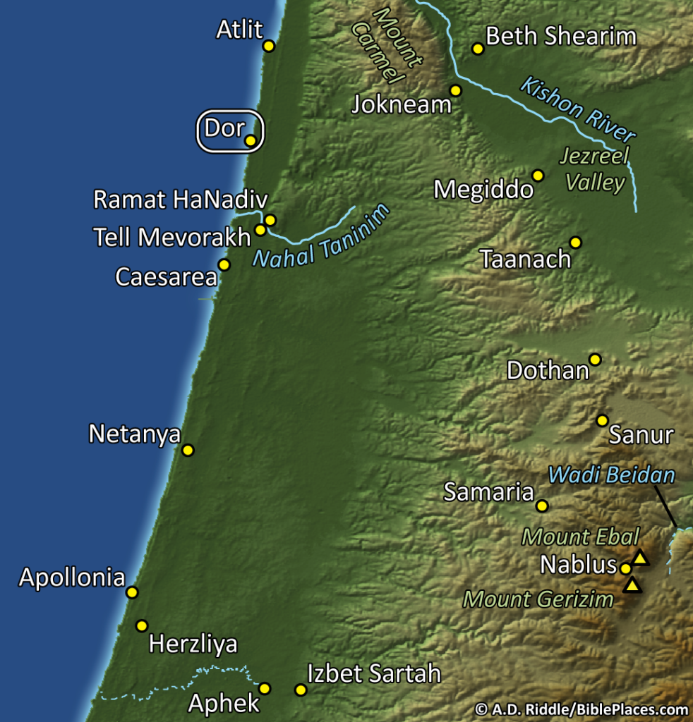
The map below is from the PowerPoint files included in Volume 2 of the Pictorial Library of Bible Lands. Dor is circled in the top left section of the map.

Tel Dor is located on the small Plain of Dor, which is nestled between Mount Carmel and the Mediterranean Sea. For a description of this small region, you can read a post I wrote on the Wild Olive Shoot blog here. In that post you will learn that this small strip of land in Israel’s central region was more often controlled by foreigners than it was by Israelites. It served as a foothold into the region for Phoenicians and the Sea Peoples. In fact, in ancient times it was easier to get to this region by boat than it was by foot, due to the marshy terrain in the area.

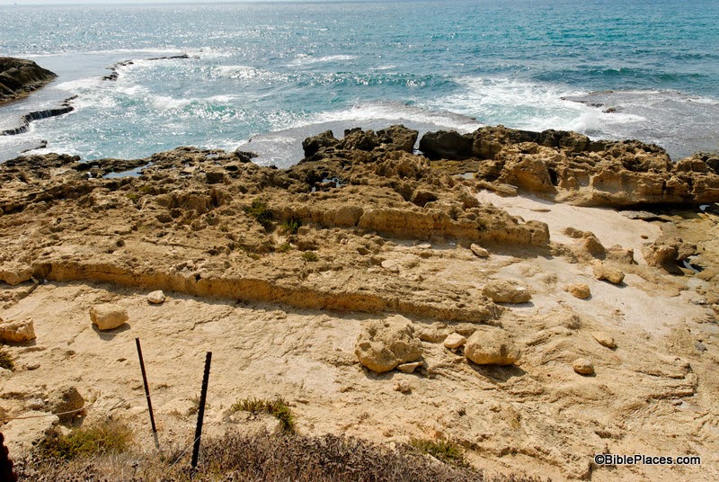
This brings us to the photo itself. Below you can see three boat slips used in ancient times by the inhabitants of Dor. The city was built right next to the sea which made it easy to haul boats in and out of the water. According to the excavators of Tel Dor, “The boat-slips are probably Hellenistic and/or Persian; they may have been dry-docks for fishing vessels, or berths for war-galleys.” (Reference: http://dor.huji.ac.il/areaE.html.) According to the photo annotations included in the PLBL, you won’t find boat slips like this at any other site on the eastern coast of the Mediterranean.

So the next time you’re in Israel, take a little time to explore this small (but significant) site. Archaeological remains from the time of Abraham to the period of the Crusaders have been found here. In addition to the boat slips, you will find the remains of a two-chambered gate from the Iron Age, two temples from the Roman Period, a purple dye factory used from the 1st to 6th centuries AD, a museum where you can see artifacts found in the area, and beautiful harbors where you can take a refreshing dip in the sea.

This photo and over 1,200 others are available in Volume 2 of the Pictorial Library of Bible Lands, which can be purchased here for $39 (with free shipping). Aerial shots of Tel Dor are available here and here on Ferrell Jenkins’s blog, and the Tel Dor excavation team has a very informative website at http://dor.huji.ac.il/. For more information on the region and additional photographs, see my post here.

Share:

(Post by Seth M. Rodriquez)


For the next few posts of our “Picture of the Week” series, we will be working our way back through the Pictorial Library of Bible Lands and focusing on obscure sites included in the collection. One of the great things about the PLBL is that it includes places that you would never typically go when you visit the lands of the Bible. Even if you spent a semester or a whole year in Israel, Jordan, Egypt, Turkey, or one of the other countries covered in the collection, you would probably not visit every site that Todd Bolen and his team of photographers have assembled in the PLBL. So this little sub-series can be called “Obscure Sites in the PLBL.” Or perhaps, “What You Missed on Your Trip to the Holy Land.”

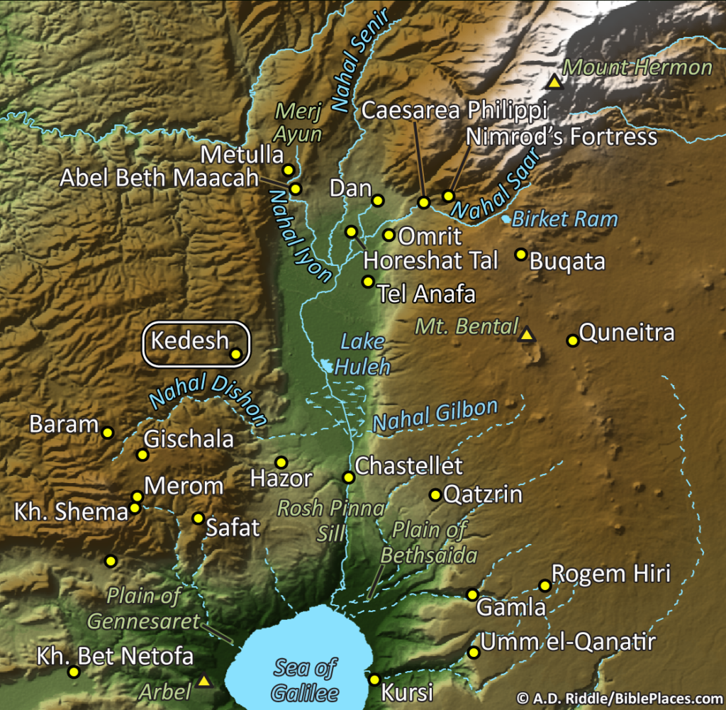
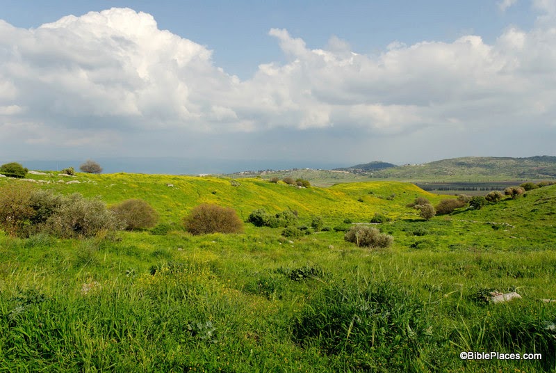
Our first stop is the ancient city of “Kedesh in Galilee in the hill country of Naphtali” (Josh. 20:7). This site is located just west of the Huleh Basin, in the region north of the Sea of Galilee. Below is a section of a map provided in Volume 1 of the PLBL which shows the location of Kedesh.

Tel Kedesh itself can be seen image below, covered with spring wildflowers. In the Old Testament period, this was one of the places designated a “city of refuge” where someone could escape from an avenger if they had accidentally killed someone (Josh. 20:1-9). There were six cities of refuge scattered throughout the Israelite territory and Kedesh was the one that was farthest to the north.

Kedesh also shows up in Judges 4. This was the where Barak lived, and it is where the Israelite army assembled before they marched out to war under the leadership of Deborah and Barak. At the time, the king of Hazor was oppressing the Israelites. Hazor is only about 8 miles southeast of Kedesh, and in the image above the camera is looking in that direction.

Lastly, Kedesh is mentioned in 2 Kings 15:29 where it was conquered by Tiglath-pileser of Assyria, along with many other cities in the region. However, the site continued to be occupied for many centuries after that. In the Roman period a temple was built here, and if you visit the site today you can see part of one wall still standing. Several pictures of the Roman temple at Kedesh are available in Volume 1 of the PLBL.

This image and over 1,100 others (along with the map) are included in Volume 1 of the Pictorial Library of Bible Lands and is available here for $39 with free shipping. Additional photographs taken in this region can be seen here, here, and here on BiblePlaces.com. Historic images of this region can be seen herehere, and here on LifeintheHolyLand.com.

Update: Another suggested location for the Kedesh of Barak is Kh. el-Kidish, southwest of the Sea of Galilee. Both of these sites were within the territory of Naphtali.

Share:

(Post by Seth M. Rodriquez)

In 1886, J. Leslie Porter finished a book called Jerusalem, Bethany, and Bethlehem which captured what life was like in Palestine in the mid- to late nineteenth century. It was in some sense a “snapshot” of the Holy Land at that time. In the book, he takes the reader on a journey from Joppa to Jerusalem and then to the surrounding regions. All along the way, he describes what you would have seen if you could have traveled there yourself and explains to you the historical significance of each place. In his own words, he says:

I have not attempted to write a learned treatise on the topography or history of Jerusalem. My task has been far simpler—to produce a book whose pictures, by pen and pencil, may perchance direct the attention of readers of all classes to scenes of absorbing sacred interest.

Things were beginning to change in Palestine during the mid-1800s, but at that point the Holy Land still looked more like the primitive culture it was in biblical times than like the modern country it became in the 1900s. You almost see the transformation taking place in the following excerpt from Porter’s work …

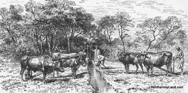
EGYPTIAN COLONISTS, JOPPA.

The road from Joppa to Jerusalem is the best in Palestine; in fact it may be said to be the only road in the country, for all others are merely bridle-paths, sometimes more like goat-tracks. The present road, thanks to French influence and money, is fit for wheeled conveyances, though the drive will call forth many a groan from those of delicate frames or weak nerves. But the scenery is fine; and the villages, people, ruins, and historic associations are sufficient to draw away the attention from physical discomfort. At first we wind through gardens of vegetables and groves of fruit-trees. Many imposing houses have recently been built; and we have all around us evidences of active life and reviving prosperity. Colonists from America, Germany, and even from Egypt, have settled here, attracted by a soil of unsurpassed fertility and a grand climate. Nowhere in the world are the orange-groves more luxuriant or the fruit of finer flavour. As we pass along we may notice the Egyptians at work in the fields, with their yokes of oxen and their ploughs so rude and primitive in design that it might be supposed they had come down unchanged from the days of Abraham. The ploughman, too, carries his goad—a weapon apparently better fitted for a lancer than a peaceful husbandman. After examining the size and make of one of those goads, I did not think the story of the sacred historian so very wonderful, that Shamgar, the Israelitish judge of old, should have slain six hundred men with an ox-goad.

To read more of the work, you can see an excerpt on LifeintheHolyLand.com by going here (for a high-resolution image) or here (for a low-resolution image). This image, about 90 other images, and the entire 170 pages of text from Jerusalem, Bethany, and Bethlehem are available here for only $15 (with free shipping). Additional images from the book can be seen here, here, and here (note that images from other historical works are shown on those pages as well).

Share:

(Post by Seth M. Rodriquez)

A few years ago while I was in grad school, one of my classmates did a presentation that included a discussion of sheep in the Ancient Near East. She learned something about sheep that surprised her very much … She was shocked to learn that sheep have tails!

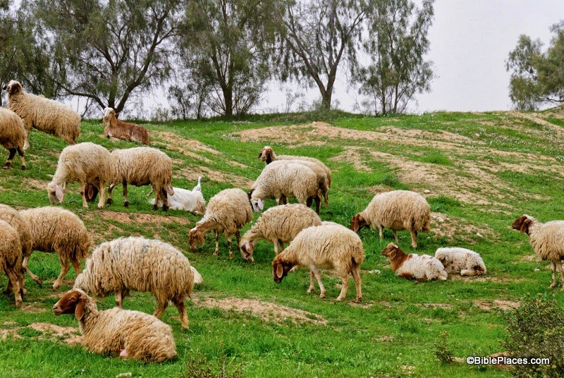
It is a common practice in many parts of the world to remove a sheep’s tail while it is young. This is done to prevent “flystrike” where flies will deposit their eggs in “stuff” that gets caught in the tail which later causes serious health issues for the sheep. (I’ll spare you the gory details, but if you would care to learn more you can go here or here … just don’t read it while you’re eating.) Consequently, many people in the world have never seen a sheep with a tail before, including my classmate. So our picture of the week comes from Volume 17 of the Pictorial Library of Bible Lands and features … you guessed it … sheep with tails (click on photo to enlarge):

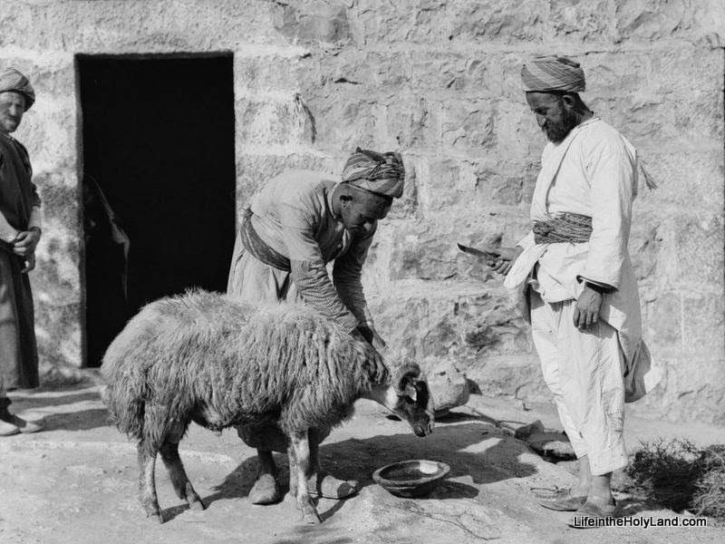
The tails on the sheep in that picture may be a little difficult to make out, so here’s an image from The American Colony and Eric Matson Collection that shows a sheep’s tail more clearly (you get two-for-one this week):

By the way, the sheep in that picture is about to be slaughtered (hence the knife).

So now that you have been enlightened that sheep even have tails, let’s turn to a biblical text where these tails are mentioned. In Leviticus 3, Moses details the process for making a peace offering to the Lord. In verses 6 through 11, he describes the steps involved if this offering is a sheep:

If his offering for a sacrifice of peace offering to the Lord is an animal from the flock, male or female, he shall offer it without blemish. If he offers a lamb for his offering, then he shall offer it before the Lord, lay his hand on the head of his offering, and kill it in front of the tent of meeting; and Aaron’s sons shall throw its blood against the sides of the altar. Then from the sacrifice of the peace offering he shall offer as a food offering to the Lord its fat; he shall remove the whole fat tail, cut off close to the backbone, and the fat that covers the entrails and all the fat that is on the entrails and the two kidneys with the fat that is on them at the loins and the long lobe of the liver that he shall remove with the kidneys. And the priest shall burn it on the altar as a food offering to the Lord. (Lev. 3:9-11, ESV.)

The photo annotations included in Volume 17 of the PLBL provides the following information on the subject:

Native to Israel, the fat-tailed Awassi sheep is white with a brown or
black head and feet. Their tails can weigh as much as 33 pounds on females and
22 pounds on males, and are similar to the humps of the camel in that they
store nutrients in order to sustain the sheep in times of scarcity. Together
with their high tolerance of heat and fast replacement of water, this enables
them to survive in the desert climate of the Negev.

So once again we see that a single picture can go a long way in illuminating the biblical text. When you woke up this morning, you may not have even known that sheep have tails! But now you can see how the whole animal, from head to tail, was involved in making a peace offering to God back when the Tabernacle and Temple were still standing.

The top photograph and over 1,000 others are included in Volume 17 of the Pictorial Library of Bible Lands, and is available here for $34 (with free shipping).

The bottom photograph and over 600 others are included in Volume 6 of The American Colony and 
Eric Matson Collection, and is available here for $20 (with free shipping).

For additional pictures and drawings of sheep from the PLBL and HVHL collections, see here, here, and here.

Share: