fbpx

(Post by Seth M. Rodriquez)

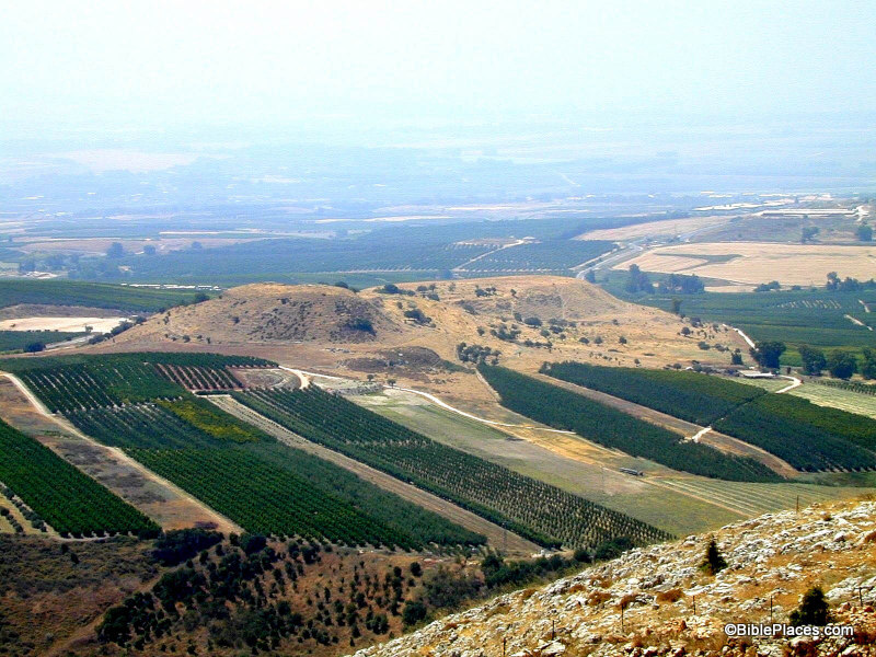
Our photo of the week is a profile of the small, but significant site of Abel-beth-maacah. If the name doesn’t ring a bell, then allow me to refresh your memory with a story …

During the reign of David, shortly after the time when Absalom tried to usurp the throne, a man named Sheba rebelled against David and led away the entire northern kingdom (2 Sam. 20:1-2). So David sent Joab and some of his soldiers to pursue him. Joab and his troops were coming up from the south, so naturally Sheba headed north.  In fact, he kept running north until he reached one of last cities before reaching Israel’s northern border: the city of Abel-beth-maacah (2 Sam. 20:14).

Unfortunately for him that proved to be a poor choice. While Joab was attacking the city, things took a turn to everyone’s advantage (except Sheba’s):

Then a wise woman called from the city, “Listen! Listen! Tell Joab, ‘Come here, that I may speak to you.’” And he came near her …. Then she said, “They used to say in former times, ‘Let them but ask counsel at Abel,’ and so they settled a matter. I am one of those who are peaceable and faithful in Israel. You seek to destroy a city that is a mother in Israel. Why will you swallow up the heritage of the Lord?” Joab answered, “Far be it from me, far be it, that I should swallow up or destroy! That is not true. But a man of the hill country of Ephraim, called Sheba the son of Bichri, has lifted up his hand against King David. Give up him alone, and I will withdraw from the city.” And the woman said to Joab, “Behold, his head shall be thrown to you over the wall.” Then the woman went to all the people in her wisdom. And they cut off the head of Sheba the son of Bichri and threw it out to Joab. So he blew the trumpet, and they dispersed from the city, every man to his home. And Joab returned to Jerusalem to the king. (2 Sam. 20:16-22, ESV)

Thus ends the story of Sheba … but not of Abel-beth-maacah. The city is mentioned two other times in the Bible. One occurrence is in the story of the war between King Asa of Judah and King Baasha of Israel (1 Kgs. 15:16-22). During the struggle, Asa is able to convince Israel’s northern neighbor, King Ben-Hadad I of Damascus, to attack Israel’s northern territories to draw Baasha away from his southern borders (1 Kgs. 15:20). Abel-beth-maacah and the neighboring city of Ijon are specifically mentioned.

The other occurrence is similar, although it records events that happened about 150 years later. In 2 Kings 15:29, Tiglath-pileser III of Assyria begins to conquer Israel by taking over its northern regions. Again, Abel-beth-maacah and Ijon are specifically mentioned.  Being situated on Israel’s northern border meant that you were first in line when an invading army showed up.

As I have mentioned before, one of the most valuable aspects of the Pictorial Library of the Bible Lands is that it includes places and things that are not normally included in a collection of biblical places. Abel-beth-maacah is a case in point. So the next time this site comes up in your OT Survey class or your Sunday School lesson or sermon preparation, you need not be content showing where Abel-beth-maacah is on a map but can also include a couple of pictures to give your listeners a feel for the place.

One final note: As I was writing this post, I was pleased to learn that a major excavation project at Abel-beth-maacah is starting this summer. Information about the dig and several additional photos of the site are available at www.abel-beth-maacah.org. They also have a Facebook page available here, and a blog here.

The photo above and over 1,100 others are available in Volume 1 of the Pictorial Library of the Bible Lands, and is available here for $39 with free shipping. Photos and information of neighboring locations are available herehere, and here on the BiblePlaces website, and here and here on LifeintheHolyLand.com.
Share:

(Post by Seth M. Rodriquez)

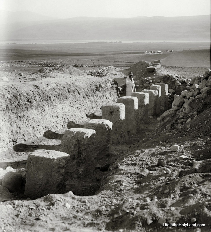
The excavation season is upon us (as has been made clear through the recent roundup posts herehere and here), so our photo of the week is a picture of some early excavations at a well known site.  Can you guess which site it is?

Here are a series of hints for you:

  • This photograph was taken sometime between 1928 and 1946.
  • This dig was carried out by John Garstang.
  • The Arabic name for this site is Tell el-Qedah.
  • A row of matching pillars was found only a few yards away.
  • The valley in the background is the Huleh Valley.
  • This building was later fully excavated by Yigael Yadin, and eventually was moved to a different place on the tell by Amnon Ben-Tor.

The answer to our riddle (and a picture of the whole structure) can be found here.

During a sounding at this site in 1928, Garstang found one of the rows of pillars in a Israelite tripartite pillared building.  This type of structure was common in the ninth and eighth centuries B.C. and has been found at Megiddo, Hazor, Beersheba, and elsewhere in Palestine.  The function of these buildings has been debated, with some scholars interpreting them as stables and others interpreting them as storehouses.  The last I checked, the proponents of the “stable” interpretation had the upper hand … but the readers of this blog are welcome to start the debate again in the comments section.

And for all of you who are in the field this summer … Happy Digging!  May you be as fortunate as Garstang was in his brief sounding at Tell el-Qedah in 1928.

This photo and about 600 others are available in Volume 1 of the American Colony and Eric Matson Collection, and can be purchased here for $20 (plus free shipping). Additional images of this site can be seen here on BiblePlaces.com.  Additional images of the Huleh Valley in the 1800s and early 1900s can be seen here on LifeintheHolyLand.com.

Share:

(Post by Seth M. Rodriquez)

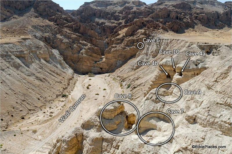
This seems to be a week where Hebrew scrolls are in the news more often than normal (see herehere, and here), so our picture of the week focuses on the Qumran caves where some of the Dead Sea Scrolls were found.  If you have ever studied the Dead Sea Scrolls, you have probably heard statements such as “The Copper Scroll was found in Cave 3,” or “The Habakkuk Commentary was discovered in Cave 1,” or “Cave 11 contained 30 scrolls.”  The scrolls are even labeled using the cave number as part of the reference, such as 2Q3 from Cave 2 at Qumran and 11Q19-20 which was found in Cave 11 at Qumran.

Yet with eleven caves in the area with written texts, it quickly becomes difficult to keep them all straight.  Fortunately the Pictorial Library of Bible Lands is available to help walk you through the location of each cave, provide pictures of the outside of each cave (and sometimes pictures from within!), and helpful commentary on which scroll was found where.  It is a great way of exploring the caves without the cost of traveling to the Dead Sea, without hiking through the blistering heat of the desert, and without any of the risks involved in climbing onto the edge of steep cliffs with loose gravel below your feet.  (Thanks for doing all the legwork, Todd!)

The picture above is a prime example of the resources available in the Qumran Caves collection in Volume 4 of the PLBL (click the image to enlarge).  The site of Qumran is to the right, outside of the frame. The photographer is facing west, looking at the edge of the hills of the Judean Wilderness.  In the shot, you can see six out of the eleven Qumran caves: Caves 4, 6, 7, 8, 9, and 10. (Please note that the image above includes the labels from one of the PowerPoint® slides. The photograph by itself without any labels is also provided in the collection.) Much of Caves 7 through 10 have eroded away, but their positions can still be seen.  Cave 4 yielded a large number of scroll fragments and is typically the one photographed in Bible dictionaries and other reference works.

The value of a shot like this becomes apparent when you are trying to give a lecture to your students on the Dead Sea Scrolls. With a picture like this, you can easily explain the arid terrain, the difficulty of reaching the caves, and their relative positions to one another.  Within the collection, each cave is photographed from various angles so that you can get a feel for its size and shape.

The collection is also useful if you are planning a trip to the site.  I only wish I could have had these pictures and diagrams with me the last time I visited Qumran so that I could pick out the location of each cave while standing there.  The PowerPoint® notes even include instructions on how to get to some of the harder to reach caves when you are on-site (although the reader is cautioned against visiting Caves 1 and 2 because of the difficult terrain).

So whether you are preparing for a lecture on the Dead Sea Scrolls, are packing for a trip to Israel, or just want to learn more about the place where the scrolls were found, the PLBL offers a valuable guide to the Qumran caves.

This photo and over 1,500 others are available in Volume 4 of the Pictorial Library of Bible Lands and is available here for $39 with free shipping.  For additional photos and information on the Qumran caves, visit this page on the BiblePlaces website.

Share:

(Post by Seth M. Rodriquez)

Most readers of this blog are familiar with reconstructions, sketches, and diagrams of the Tabernacle.

From our reading of the text and with some help from Bible encyclopedias and study Bibles, we know the Tabernacle inside and out … the courtyard, the altar, the tent itself with its various coverings, the outer room, the Holy of Holies, the various articles in the rooms, how the items were arranged in the court and in the tent, etc., etc.

But did you ever stop to think what the Tabernacle looked like to an ancient Israelite?  I’m not talking about the priests and Levites who ministered in the Tabernacle, but just your average Israelite man or woman who would have passed by the Tabernacle on their way from one side of the camp to the other.  What it would have looked like to their kids as they approached the Tabernacle, bringing the sacrificial animals that God had required?  How much of God’s tent could the average person see from outside the courtyard?

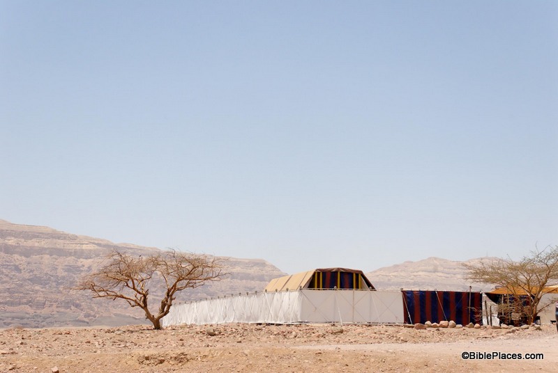
Our picture of the week seeks to portray just that:

This photo comes from Volume 5 of the Pictorial Library of Bible Lands which focuses on the Negev and the Wilderness.  Within this volume you will find a collection of pictures that captures a life-sized replica of the Tabernacle that stands in the Timna Valley in Israel.  The PLBL states the following about the replica’s history:

The model was created in 1986 by the Bible Center Theological Vocational School in Breckerfeld, Germany. It was displayed at exhibitions in seven European cities, mainly in Germany and Switzerland, before being erected in the Timna Valley.

You can see better pictures of the model on the BiblePlaces website here, but this particular image caught my attention because it is what the average Israelite would have seen on an average day.  The outer screen of the Tabernacle’s courtyard blocked most of the tent from view (Exod. 27:9-18), but someone standing outside could still see the top of the Tabernacle itself over the top of the screen.

We know this because the height of the Tabernacle was at least 10 cubits (Exod. 26:15-16) while the height of the screen was around 5 cubits (Exod. 27:18), so the screen was only half as high as the tent.

A cubit is the length from the tip of your fingers to the tip of your elbow, thus in modern measurements a cubit is approximately half a meter or 18 inches.  So to be more exact, the Tabernacle stood at least 5 meters (15 feet) tall and the screen was about 2.5 meters (7.5 feet) high.  You would not be able to see anything if you were standing right next to the screen (unless you were extremely tall, like Goliath), but if you stood back away from the screen, the top of the Tabernacle could be seen towering over its surroundings.

On the one hand, the screen would have served as a reminder of the separation between a holy God and sinful man.  Yet on the other hand, the tent itself was a visible reminder of the nearness of God.

The book of Exodus teaches that God didn’t deliver Israel from Egypt and then just walk away, but instead He delivered them so that He could dwell among them:

Then I will dwell among the Israelites and be their God. They will know that I am the Lord their God, who brought them out of Egypt so that I might dwell among them. I am the Lord their God. (Exod. 29:45-46.)

This image and over 700 others are available in Volume 5 of the Pictorial Library of Bible Lands and can be purchased here for $34 (with free shipping).  Additional information and images of the Tabernacle model can be seen here and here on the BiblePlaces website.  For my thoughts about what happened to the Tabernacle after it was retired, see my posts on the Wild Olive Shoot blog here and here.

Share:

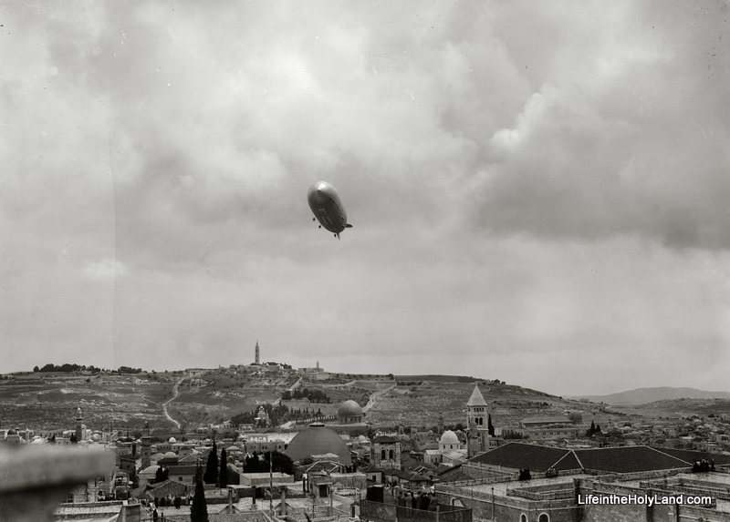
Our picture of the week is one of the most surprising images in any of the collections available on BiblePlaces.com and LifeintheHolyLand.com.  It was taken on April 11, 1931 and displays a German dirigible floating over Jerusalem.

Several familiar landmarks can be clearly seen in the photograph. (You can click on the image to enlarge it.)  The dirigible is hovering over the Church of the Holy Sepulcher, and the Dome of the Rock can be seen in the background just above the church’s dome.  To the right is the tower of the German Lutheran Church, and framing the whole scene in the background is the Mount of Olives.

The photo comes from Volume 2 of the American Colony and Eric Matson Collection which focuses on Jerusalem.  There is another photo of this zeppelin in that collection which shows a clear profile of the airship as it passed by the Citadel of David near Jaffa Gate.

How and why did a zeppelin get here in 1931?  The PowerPoint® notes in the collection provide the following explanation (hyperlinks in the quote were added for the convenience of our readers):

The viewpoint is a rooftop, or perhaps the city wall, in the Christian Quarter, west of the Holy Sepulcher. The photo documents the visit of the German dirigible “Graf Zeppelin” to Jerusalem on April 11, 1931. The famous airship began its journey on April 9th in Friedrichshafen, Germany and it landed at Heliopolis near Cairo at dawn on the 11th. It then set off on a one-day, round-trip excursion to Jerusalem, reaching there at 10 a.m. The airship reportedly hovered for some time, with its engines stopped, about 100 meters above the Church of the Holy Sepulcher, and that seems to be exactly what was captured in this photo. That date–April 11, 1931–being Holy Saturday in the Eastern calendar, the dirigible’s passengers were almost certainly viewing the colorful spectacle of the annual “Holy Fire” ceremony being played out in the streets below.  Without touching down in Palestine, the Graf Zeppelin (average speed approx. 60 miles (100 km) per hour) returned to Egypt and landed in Cairo at 4 p.m. the same day.  [Source: web-site of the German Embassy in Cairo, www.kairo.diplo.de]

This particular zeppelin traveled the world over the course of a decade.  It crossed oceans, traversed hemispheres, made a “round the world” voyage, and even helped explore the Arctic.  With such a colorful career, I guess it couldn’t resist squeezing in a quick trip to Jerusalem at some point.

This photograph and over 650 others are available in Volume 2 of the American Colony and Eric Matson Collection, and is available here for $25 (with free shipping).  Further information and images of Jerusalem in the 1800s and early 1900s can be found on LifeintheHolyLand.com here, here, and elsewhere.  Further information on the Graf Zeppelin can be found here and here.

Share:

(Post by Seth M. Rodriquez)

Jesus began one his parables by saying, “A man was going down from Jerusalem to Jericho and he fell among robbers, who stripped him and beat him and departed, leaving him half dead.” (Luke 10:30, ESV.)  Thus began the well-known “Parable of the Good Samaritan.”  Although that particular route would have been well-known to Jesus’ hearers, most readers of the Bible today are not familiar with it.

Enter the Pictorial Library of the Bible Lands … One of the most admirable features of the PLBL is that it takes you to out-of-the-way places that you have never visited but always wished that you had.

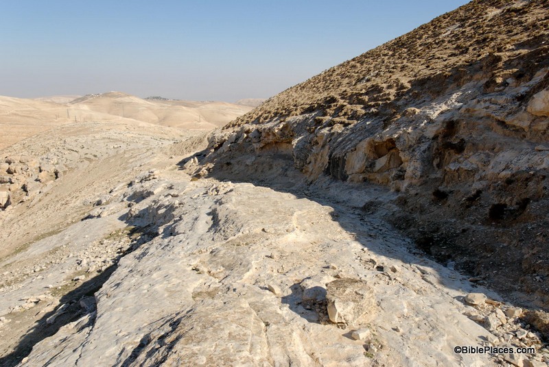
Our picture of the week is from Volume 4 of the PLBL and shows us the remains of the Roman road that led from Jerusalem to Jericho in Jesus’ day.  Elsewhere in the Bible, this route is referred to as the Ascent of Adummim (Josh. 15:7; 18:17).

In the picture, the viewer is looking east toward the rugged hills of the Judean Wilderness that lie between Jerusalem and Jericho.  In the foreground the remains of the road can be seen stretching out before the feet of the photographer.  The small cliff to the right seems to be man-made and was probably cut to give more space for the road. Only the foundation of the road remains today.

The PowerPoint notes from the PLBL provide the following insights into this significant road (the links have been added to the notes for the benefit of our readers):

The “Ascent of Adummim” was the main route from Jericho to Jerusalem in antiquity. It followed a ridge located south of the Wadi Qilt and north of Nahal Og, and near Jerusalem was forced to cross the Nahal Og at a more passable location. Among the biblical events which likely occurred on this route were David’s flight from Absalom (2 Sam 15-16), Zedekiah’s flight from the Babylonians (2 Kgs 25:4), the story of the Good Samaritan (Luke 10:25-37), and Jesus’ travels from Jericho to Jerusalem (e.g., Luke 19:28).

How long does it take to walk from Jericho to Jerusalem? On one recent occasion, it took a group of hikers 8 hours to cover the distance of 15 miles (24 km), with an elevation gain of about 3,400 feet (1,060 m). Not counting breaks, we walked for six and a half hours. Had it been hotter or had we run into any difficulties, the journey would have taken longer.

Jesus traveled this route many times. He likely came this way most of the times that he journeyed to Jerusalem from Galilee, though we know of at least two occasions when he attempted to travel through Samaria (John 4; Luke 9:52-53). Scripture records at least two trips by way of Jericho, but he probably went this way dozens of times in his life. It’s a reasonable conclusion that Jesus’ parents had to climb back up this route to Jerusalem after realizing that their twelve-year-old son was not in their caravan (Luke 2:41-50). Parts of the Roman road are still visible in places, and the way today is safe and pleasant.

This picture and over 1,500 others are available in Volume 4 of the Pictorial Library of Bible Lands and is available here for $39 (with free shipping).  More photos and information about this region are available on the BiblePlaces website here.  For further discussion and images that illustrate the story of the Good Samaritan, see this page on LifeintheHolyLand.com.

Share:
About the BiblePlaces Blog

The BiblePlaces Blog provides updates and analysis of the latest in biblical archaeology, history, and geography. Unless otherwise noted, the posts are written by Todd Bolen, PhD, Professor of Biblical Studies at The Master’s University.

Notice

As an Amazon Associate we earn from qualifying purchases. In any case, we will provide honest advice.