fbpx

(Post by Seth M. Rodriquez)

This was a difficult week to come up with a photo to share.  The problem wasn’t due to a lack of good material … the problem was that there were too many good photos available!

This week’s photo comes from Volume 2 of The American Colony and Eric Matson Collection, which focuses on Jerusalem.  These are photographs of Jerusalem taken in the first half of the 20th century before many of the modern developments were built.  So much has changed in the city since that time (both physically and politically) that this volume is a gold mine of material for Jerusalem studies.

Here is a list of some of the photos I could have chosen for this week’s post:

  • The City of David when it was still being used for farmland.
  • A German zeppelin hovering over the Old City.
  • The interior of the Golden Gate on the Temple Mount.
  • The interior of the Double Gate on the Temple Mount.
  • The interior of Solomon’s Stables in the Temple Mount (but see here for a similar photo).
  • The interior of the Hurvah Synagogue before it was destroyed in the War of Independence.
  • The Pool of Hezekiah filled with water instead of trash (but see here for similar images).
  • Sealed entrances to the Church of the Holy Sepulcher.
  • The short-lived and aesthetically questionable clock tower built on top of Jaffa Gate (but see here for a previous post on that subject).
  • Remains of a Crusader-period monastery in the Kidron Valley, a small portion of which was only briefly excavated in 1937 and then buried again.
  • Crowfoot and Fitzgerald’s 1927-28 excavations in the City of David.
  • A smog-free landscape looking east which includes the Hinnom Valley, Mt. Zion, the Judean Wilderness, the Dead Sea, and the mountains of Moab.
  • The Jewish Quarter and the Western Wall as they looked before the War of Independence (but see here for a similar photo).

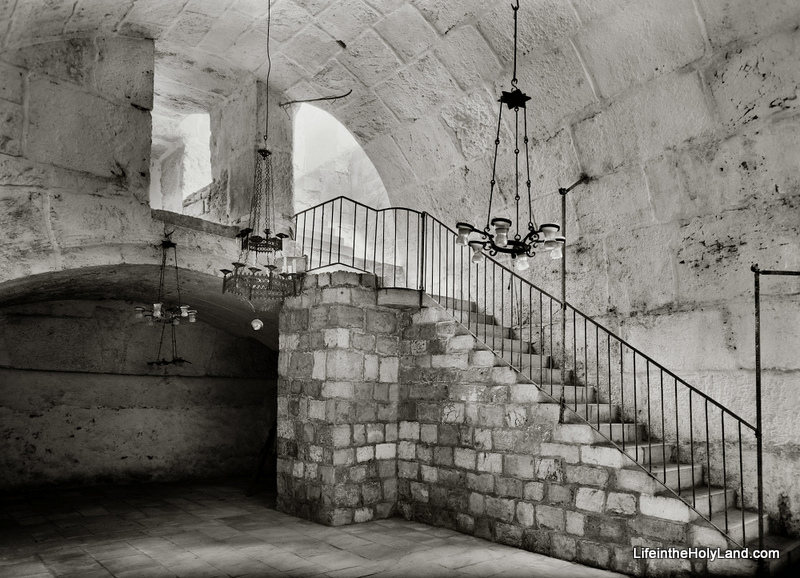
Instead, I will present the following rare photo of the interior of Barclay’s Gate (or at least the top section of the gate) on the western side of the Temple Mount, taken sometime between 1940 and 1946.


Barclay’s Gate was one of the entrances to the Temple Mount during the Second Temple Period (the time of Jesus and the apostles). A modern photo of the outside of Barclay’s Gate, in the women’s area of the Western Wall Plaza, can be seen here.  Only the stone that formed the lintel is visible today from the outside.  In the PowerPoint notes included in the collection, Tom Powers explains what we can see in the photograph above:

This fascinating photograph (looking northwest) shows a room lying beneath the surface of the Temple Mount (to Muslims, the Haram esh-Sharif, or “Noble Sanctuary”). This space was the subject of several descriptions and drawings by 19th century explorers but has rarely been seen by Westerners—or photographed. Much better known, actually, is the opposite side of the thick wall seen here at the end of the vaulted room: it is the massive lintel and blocked opening of an original western entrance of the Herodian Temple Mount, the so-called “Barclay’s Gate” partially visible in the very southern end of today’s Western Wall (women’s prayer area).  

The ancient gate was identified in modern times by James T. Barclay, an American Protestant medical missionary and amateur explorer of Jerusalem’s ancient places. In the course of recounting his identification of the exterior gate elements, Barclay also described the space pictured here: 

“During the period of my admission into the Haram enclosure I discovered in this immediate vicinity, on the interior, a portion of a closed gateway, about fourteen or fifteen feet wide; but whether it is connected with that on the exterior, I was not enabled to determine, for the guards became so much exasperated by my infidel desecration of the sacred room, el-Borak, where the great prophet tied his mule on that memorable night of the Hegira, that it was deemed the part of prudence to tarry there but a short time and never to visit it again . . . . Only the upper portion of the gateway can be seen—the lower part being excluded from view by a room, the roof or top of which is formed by the floor of this small apartment.”
— James Barclay, City of the Great King (1857), pp. 490-91 

In the passage quoted above Barclay, alas, garbles some elements of the Muslim tradition (he calls the mythical beast a “mule” and confuses Mohammed’s Night Journey with the hegira, his flight from Mecca to Medina). Nonetheless, his notion that this “small apartment” might be connected to the gate he had identified from the outside was correct, as confirmed by other explorers only several years later. Barclay was also correct that the mosque occupied only the uppermost part of the gateway. But, whereas Barclay presumed the existence of a lower room, the mosque actually overlies a great volume of debris deposits (or fill) behind the blocked gate. 

In this photo, the vaulting overhead is the top of the Herodian gate passage, and the dark line in the masonry of the far wall (beneath the shallow arch) corresponds to the bottom of the great lintel (apparently the lintel itself is not visible). Experts estimate the height of the Herodian gate opening, from sill to lintel, at 25 to 30 feet (7.8 to 9.3m), with the sill lying only a few yards (meters) above the Herodian street. Thus, in the original gate passage here, a broad stairway no doubt ascended (far beneath the floor shown here) toward the east and the surface of the Temple Mount. The original passage ran eastward from the western wall for at least 70 feet (22 m), but it was reconfigured and altered in many ways over the ages. For example, the distinctive arch of chamfered voussoirs (beveled and molded arch-stones) seen here, and others like it, point to a major redesign and rebuilding of the passage in Omayyad times (7th-8th centuries), when the gate was still open and in use. Since the Arab chronicler Al-Muqadassi in 985 still lists the gate (called by him, and all previous Arab sources, Bab Hitta) among the active entrances into the Haram, it must have gone out of use and was blocked sometime after that date. The eastern part of the passage was walled off at some point, plastered, and used as a cistern. 

The “al-Buraq” Mosque pictured here, again, is built into the vaulted internal gate passage of Barclay’s Gate, along the western wall and inside the Haram (Temple Mount) enclosure. It is situated immediately next to the Mughrabi Gate, to the north, and below the level of the Haram platform, from which it is accessed by the two flights of stairs pictured here. The Matson-supplied date for this photo is 1940 to 1946, and the mosque apparently still exists today. … 

This photograph and over 650 others are available in Volume 2 of The American Colony and Eric Matson Collection and can be purchased here for $25 (with free shipping).  Other historic photos can be seen on various pages of LifeintheHolyLand.com.  You can find the links the Jerusalem pages in the left column of the homepage.
Share:

(Post by Seth M. Rodriquez)

It is impossible to send a photographer back to biblical times to capture the sights that were familiar to Abraham, David, and Peter…but a photographer taking pictures in the early 20th century could come pretty close.

Our picture of the week comes from Volume 1 of The American Colony and Eric Matson Collection.  This is a remarkable collection of photographs from the first half of the 20th century.  I had a hand in the early stages of this project, working through and cataloging thousands of photos.  It was a remarkable experience and in the process I learned much about the cultures of that period, the daily life of the inhabitants, the notable events of the day, and the various archaeological sites.  The collection published by LifeInTheHolyLand.com is a selection of the best of the photographs taken by the American Colony and Eric Matson.  Over 4,000 photos from Palestine, Lebanon, Syria, Jordan, and Egypt are presented in eight volumes. We will spend the next few weeks highlighting a photo from each volume. LifeInTheHolyLand.com describes the collection in this way:

Founded in 1881 by Horatio Spafford (author of the famous hymn, It is Well With My Soul), the American Colony in Jerusalem operated a thriving photographic enterprise for almost four decades. Their images document the land and its people, with a special emphasis on biblical and archaeological sites, inspirational scenes, and historic events. One of the photographers, G. Eric Matson, inherited the archive, adding to it his own later work through the “Matson Photo Service.”

As you spend time in the collection, you really do feel like you have stepped back in time.  The landscapes are picturesque because buildings are sparse or non-existent and the air is free from smog. The local villages are full of primitive dwellings while the new churches, hospitals, and municipal buildings are pristine.  You see dirt roads, horse-drawn carriages, boats powered by wind, and people walking from one town to the next.  Archaeological sites are untouched by the excavator’s spade or are being subjected to excavation for first time.  What an amazing time to be a photographer in the land of the Bible!

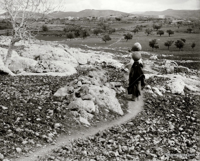
For example, as I was looking through Volume 1 the picture above stood out to me.  Two women are walking barefoot along a narrow, dirt path in the hills of Ephraim, balancing water jugs on their heads.  Behind them is the small town of Lower Beth Horon surrounded by farmland and a handful of trees.  You can almost feel the silence that must have hung in the air in this sleepy countryside.  Such a scene must have been familiar during the biblical period, and a photo such as this has the ability to transport us back to biblical times and to help us read Scripture in its historical context.

This photograph and 600 others are available in Volume 1 of The American Colony and Eric Matson Collection and can be purchased here for $20 (with free shipping).  Volume 1 focuses on “Northern Palestine,” and other photos from the volume can be seen here, here, and elsewhere on LifeInTheHolyLand.com.  Images and information about other work carried out by women during this period can be found here.

Share:

(Post by Seth M. Rodriquez)

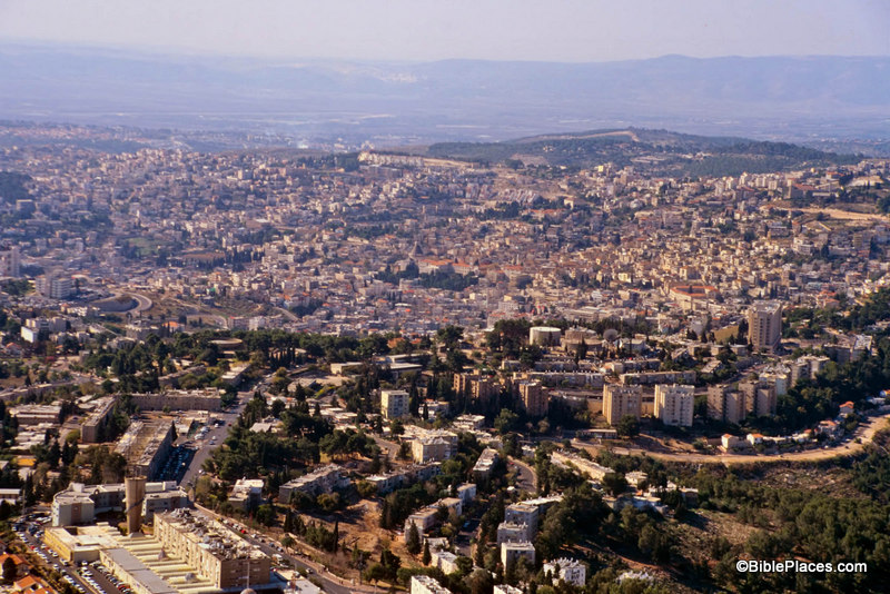
Why is it that the more important the biblical site, the more it tends to be surrounded by modern buildings?  Sites such as HazorMegiddo, and Gezer have a lower level of biblical significance (see 1 Kings 9:15) yet they are delightful places to visit because they are relatively untouched by modern developments.  But take a city like Jerusalem, Bethlehem, or Nazareth, and you need to hire a professional guide to help you find the ancient remains among the modern.

Take Nazareth for example.  I have been to Nazareth a number of times, but I have seen few (if any) ancient remains in that city.  It is completely covered by modern buildings.

Nazareth Today

This is not to criticize the modern inhabitants of the city.  They have a right to live there and build comfortable houses and reliable roads.  I am merely pointing out that often modern developments can diminish the usefulness of a location for teaching purposes.  This is why a site such as LifeInTheHolyLand.com and the resources available through that site are so helpful.

Our picture of the week comes from a book entitled Earthly Footsteps of the Man of Galilee, which has been reproduced in electronic form and is available through  LifeInTheHolyLand.com.  It contains nearly 400 photographs taken in 1894.  The book follows the life of Christ and the apostles chronologically, traveling back and forth through various countries.  Below is a picture entitled

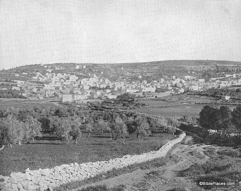
“Nazareth from the East” and is followed by an excerpt from the book.  In this image, the city of Nazareth is much smaller than it is today.  The Nazareth of 1894 was probably much larger than the Nazareth of the 1st century, and yet this photograph provides a better impression of the Nazareth that Jesus knew than any modern photograph could hope to reproduce.

Nazareth in 1894

NAZARETH FROM THE EAST.–After an absence, according to Dr. Andrews, of something like six months, the Holy Family with the infant Jesus came in sight again of their own home.  If they approached the city from the East they would get the view, as far as the topographical features are concerned, given above.  Nazareth stands almost mid-way between the Jordan and the Mediterranean Sea, as we have already said.  It lies on the eastern slope of the hill, from the summit of which a magnificent prospect opens out.  Toward the north are the hills of Galilee and the majestic summits of the snow-crowned Hermon.  On the east is the Jordan valley and in dim outline the heights of the ancient Bashan.  To the south spreads the beautiful plain of Esdraelon, with Mount Tabor, Little Hermon and Gilboa; in sight, beyond, are the hills of Samaria, and on the west Carmel faces the blue waters of the Mediterranean.  No traveler should miss this view from the hill behind Nazareth.  It is perhaps the richest and most extensive in all Palestine.  The nearer hills are wooded, and drop in graceful slopes to broad and widening valleys of “living green.”  In the village below, upon this eastern slope, the Savior of the world passed his childhood.  His feet must frequently have wandered over these hills, and his eyes looked again and again from the summit as do the eyes of pilgrims now.  Here the Prince of Peace looked upon the great plain of Esdraelon, where had so often been heard the din of battle; and upon that sea over which the swift ships were to bear the tidings of his salvation to continents and nations then unknown.  The history of Nazareth seems to cluster about one remarkable event, “The Annunciation.”  Before that the place was unknown.  But to the Christian, Nazareth is the home of the Savior’s boyhood; the scene of his early labors, his prayers, his domestic relations, his whole private life for thirty years.  This gives unspeakable charm to the town.

Quote taken from John H. Vincent, James W. Lee, and R. E. M. Bain, Earthly Footsteps of the Man of Galilee (New York: N. D. Thompson Publishing, n.d.), p. 101, which can be purchased here.  The entire work contains almost 400 images, each with an explanatory note. Additional images of Nazareth can be seen here (1800s and 1960s) and here (modern day).

Share:

(Post by Seth M. Rodriquez)

If you have been to Israel today then chances are that you flew there and your first glimpse of the country was from the air.  But what was it like to visit the Holy Land before the luxuries of modern travel?

Our picture of the week comes from a book written in the 1880s by a scholar and traveler named J. L. Porter.  The book is called Jerusalem, Bethany and Bethlehem and chronicles Porter’s travels and reflections in the Holy Land. It has been reproduced electronically and is available through LifeInTheHolyLand.com.

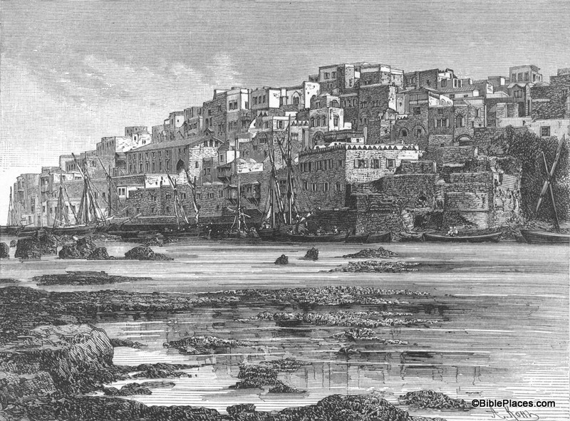
Joppa from the Southwest

In the introduction, Porter describes the port city of Joppa.  Today Joppa is engulfed by the modern city of Tel Aviv, but in Porter’s day it stood alone and was one of the most common places for travelers to enter the Promised Land.  In the picture you can see the shallow waters of the Mediterranean and the city rising above the boats in the harbor.  The following excerpt gives you a taste of Porter’s writing style as he describes his experience in this city:

     Joppa is one of the oldest cities in the world. Pliny says it was founded before the Flood; and Josephus attributes its origin to the Phoenicians in the earliest stage of their commercial enterprise. Strabo has another story, making it the scene of Andromeda’s exposure to the sea-monster.
     But Joppa has a far higher claim upon our attention than could be given by heathen fables, or by even the most extravagant ascription of mythical antiquity and commercial greatness. It was the port of Jerusalem three thousand years ago, when the mariners of Hiram brought down timber from Lebanon for the building of the Temple. It is the port of Jerusalem to this day [in 1886]. Most Western travellers there first touch the sacred soil of Palestine, and thence go forward on their pilgrimage journey to the Holy City. …
     When one reaches the shore, through barriers of rocks,—rather a difficult and even dangerous task if the wind happens to blow from the west,—he is charmed at once with the quaintness of the streets and houses, the picturesque beauty of the fountains, gates, and Crusaders’ walls, and the crowd of people dressed in the costumes of nearly every country of Europe and Asia. … The views obtained from the terraced roofs of the higher houses of the town, and from some of the old towers along the walls, are singularly rich. The eye roams over a vast sea of verdure, many-tinted and varied in outline, with the palm, the pomegranate, the spreading terebinth, the golden orange and lemon, and the stately cypress. Beyond the orchards appear wide reaches of the green meadows and corn-fields of the Plain of Sharon; while on the eastern horizon, miles away, is the long range of the Judean hills, delicately coloured with light-gray summits, russet sides, and deep purple glens. It is a grand panorama, and, as it seemed to me, it is a fitting introduction to the traditional and historic glories of the Promised Land. 

Quote taken from J. L. Porter, Jerusalem, Bethany and Bethlehem (London: Thomas Nelson and Sons, 1887), pp. i-ii, which can be purchased here.  The entire work contains over 90 images and almost 200 pages of text.  Additional images of Joppa can be seen here (1800s) and here (modern day).

Share:

(Post by Seth M. Rodriquez)

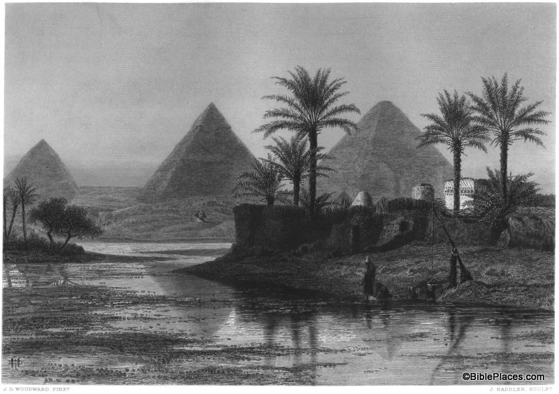
People often wonder how the Great Pyramids of Giza were built and how much work it took to construct them. But have you ever asked yourself, “How much work would it take to tear down the pyramids?” In the late twelfth century, some people tried to do just that. Volume 4 of Picturesque Palestine, Sinai and Egypt provides us with the story.

The image below is entitled “Pyramids of Gizeh” and is one of the few steel engravings in this volume.  (The rest of the images are wood engravings.)  In the section below, the author summarizes the work of a 13th century physician known as ’Abd-el-Latif of Baghdad.  ’Abd-el-Latif visited Egypt and wrote of his experiences there.  In 1196, the governing authorities decided to tear down one of the pyramids to provide raw material for a new construction project.

’Abd-el-Latif tells us how he saw the workmen of El-Melik El-’Azîz, son of Saladin, employed in 1196 in pulling down the Third Pyramid—that at the left in our steel engraving of the Three Pyramids of Gîzeh, from a sketch made during the inundation. A large body of engineers and miners pitched a camp close to the Red Pyramid (as the Third was called from its beautiful granite casing), and with their united and continuous efforts achieved the removal of one or two stones a day. The blocks fell down with a tremendous shock, and buried themselves in the sand, whence they were extricated with immense toil and then were laboriously broken up. At the end of eight months the treasury was exhausted and the work of destruction abandoned. To look at the quantity of stone taken away you would think, says the observer, that the whole monument had been razed to the ground; but when you lift your eyes to the Pyramid itself, it is hard to see that it has suffered the least diminution! One day ’Abd-el-Latîf asked one of the workmen, who had assisted in laboriously removing one stone from its place, whether he would put it up again for a thousand gold pieces? The man answered that they could not do it if the reward were many times multiplied. And so in spite of the efforts of man and the wearing of time, the Red Pyramid of Menkara still stands besides its two sisters at Gîzeh, and verifies the saying that “Time mocks all things, but the Pyramids laugh at Time.”

Quote taken from Picturesque Palestine, Sinai and Egypt, vol. 4, pp. 170-173.  This and other images of nineteenth-century Egypt are available in Picturesque Palestine, Volume IV: Sinai and Egypt and can be purchased here.  Additional images of the Giza Pyramids can be seen here and here.

Share:

(Post by Seth M. Rodriquez)

Have you ever asked yourself, “How can I make my preaching and teaching come alive? How can I grab people’s attention?” There are many ways to answer that question. Today we will look at one of them.

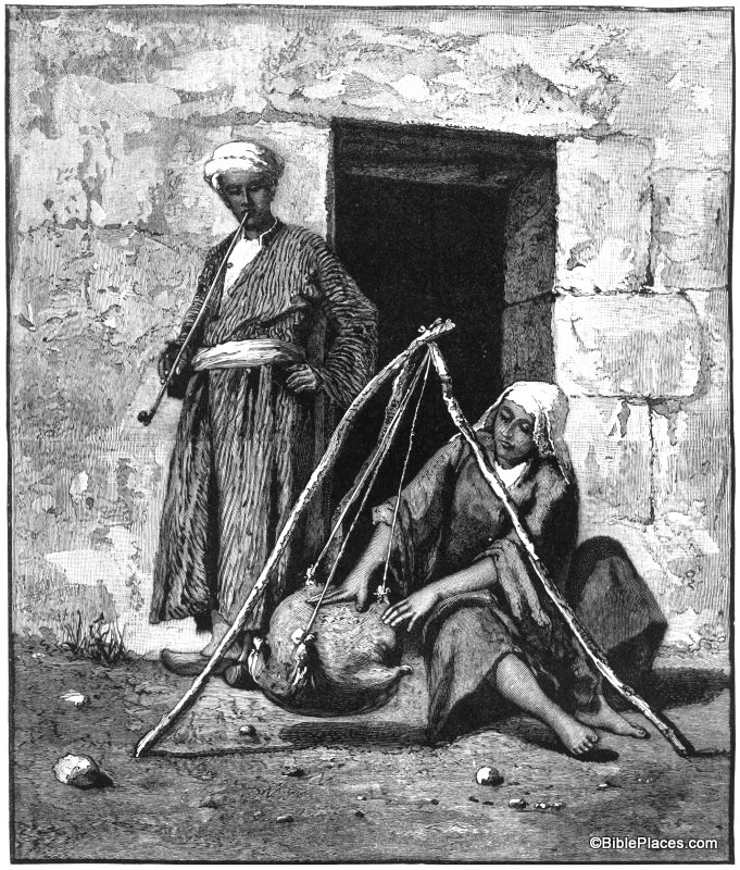
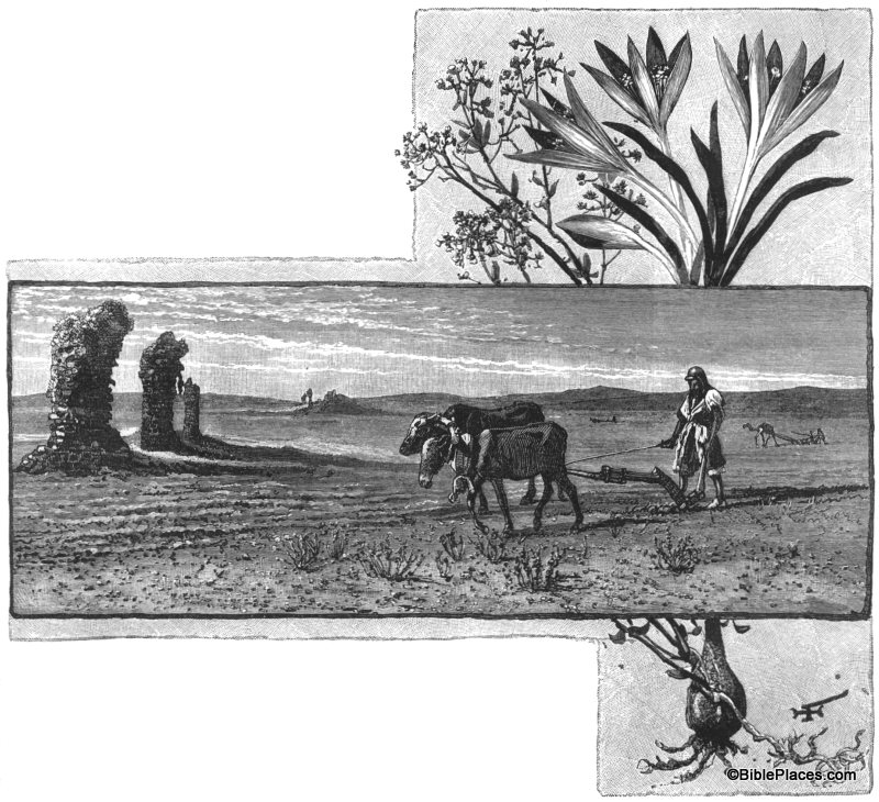
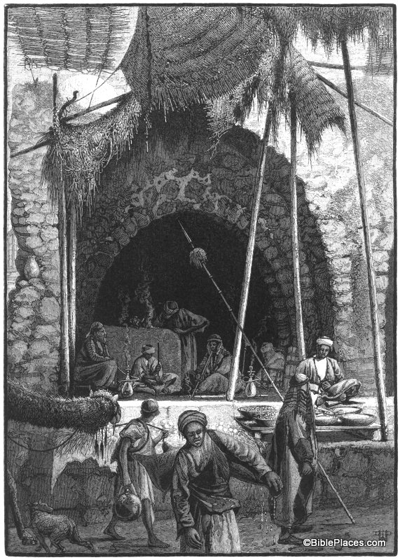
One value of a work such as Picturesque Palestine, written and illustrated in the late 1800s, is how it shows Middle Eastern culture as it was before the modern era. Things changed slowly over the centuries and in many ways the Middle East seen by the early explorers was the Middle East of biblical times. That said, many of the drawings can be used effectively in preaching and teaching to transport the listener to biblical times and grab their attention. Due to the arrival of the digital age, modern western culture is highly visual, so Bible teachers and preachers should use this to their advantage.

For example, observe how the following pictures enhance the reading of these biblical passages:

A Peasant Woman Churning

“For as churning cream produces butter,
and as twisting the nose produces blood,
so stirring up anger produces strife.”
Proverbs 30:33, NIV.

Ploughing in the Plains of Philistia

“So he departed from there and found Elisha the son of Shaphat,
who was plowing with twelve yoke of oxen in front of him,
and he was with the twelfth. Elijah passed
by him and cast his cloak upon him.”
1 Kings 19:19, ESV.

Scene in the Bazzar at Jaffa
“For the kingdom of heaven is like a master of a house who went out early in the morning to hire laborers for his vineyard. After agreeing with the laborers for a denarius a day, he sent them into his vineyard. And going out about the third hour he saw others standing idle in the marketplace, and to them he said, ‘You go into the vineyard too, and whatever is right I will give you.’”
Matthew 20:1-4, ESV.

It is often hard for people living in the modern era to get their head into the ancient world.  Pictures such as these can go a long way to painting the correct picture.

This and other images from the nineteenth-century are available in Picturesque Palestine, Volume III: Phoenicia, Philistia, and the South and can be purchased here.  Additional images of domestic work performed by women can be seen here, images of agricultural work can be seen here, and images of the marketplace can bee seen here.

Share:
About the BiblePlaces Blog

The BiblePlaces Blog provides updates and analysis of the latest in biblical archaeology, history, and geography. Unless otherwise noted, the posts are written by Todd Bolen, PhD, Professor of Biblical Studies at The Master’s University.

Notice

As an Amazon Associate we earn from qualifying purchases. In any case, we will provide honest advice.