fbpx

Information on the second Qeiyafa inscription coming later this year (Luke Chandler)
The Tel Burna Arch
aeological Project (ASOR Blog)

Israel approves drilling for oil in Golan Heights (Jerusalem Post)

John the Baptist: The First Christian Martyr (Bryant Wood)

Review of The Unsolved Mystery of Noah’s Ark (Gordon Franz and Bill Crouse)


NIV Study Bible for Kindle marked down to $6.64 (Amazon)

Ferrell Jenkins has begun a series on famous people buried in the Protestant Cemetery on Mount
Zion, including Horatio G. Spafford and James Leslie Starkey.

Online Battle Over Sacred Scrolls, Real-World Consequences (New York Times) Includes an interview with Raphael Golb.

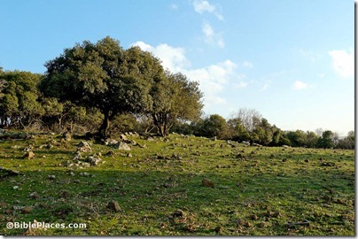
Oak forest on Golan Heights, tb020506169
Oak forest on Golan Heights
Photo from Galilee and the North
Share:

Several articles this week are related to King Herod and the new exhibit at the Israel Museum. With a lengthy list for tomorrow’s roundup, I thought a separate post might be worthwhile.

Herodium, home of the most reviled monarch in Judea – Miriam Feinberg Vamosh writes about Herod’s fortress in a free article in Haaretz.

A King on Exhibition: Herod is Ready for His Close-Up – Karl Vick gives some background on the new exhibit in Time. There are errors.

In Search of Herod’s Tomb – This article by the Herodium’s excavator, Ehud Netzer, was published posthumously in Biblical Archaeology Review.

Herod the Great—The King’s Final Journey – Suzanne F. Singer describes the museum exhibit in the current issue of Biblical Archaeology Review. A slideshow is included.

Over the years, I’ve written about sites important to King Herod, including Masada, Herodium, Caesarea Maritima, Caesarea Philippi, and Jerusalem’s Temple Mount. See also King Herod: Ten 
Things You Didn’t Know.

HT: Jack Sasson

Jerusalem model Herod's Palace from southwest, tb020101208
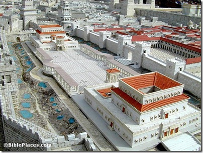
Model of Herod’s Jerusalem palace, now on display at the Israel Museum. Photo from Pictorial Library of Bible Lands.
Share:

The Israel Antiquities Authority has issued a press release on the latest discovery:

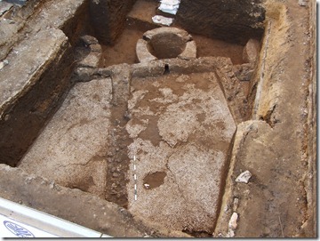
Recently impressive remains of an industrial installation from the Byzantine period which was used to extract liquid were exposed on Hai Gaon Street.
Installations such as these are usually identified as wine presses for producing wine from grapes, and it is also possible they were used to produce wine or alcoholic beverage from other types of fruit that grew in the region. Yafo’s rich and diverse agricultural tradition has a history thousands of years old beginning with references to the city and its fertile fields in ancient Egyptian documents up until Yafo’s orchards in the Ottoman period.
According to Dr. Yoav Arbel, director of the excavations on behalf of the Israel Antiquities Authority, “This is the first important building from the Byzantine period to be uncovered in this part of the city. The fact that the installation is located relatively far from Tel Yafo adds a significant dimension to our knowledge about the impressive agricultural distribution in the region in this period. The installation, which probably dates to the second half of the Byzantine period (sixth century – early seventh century CE), is divided into surfaces paved with a white industrial mosaic. Due to the mosaic’s impermeability such surfaces are commonly found in the press installations of the period which were used to extract liquid. Each unit was connected to a plastered collecting vat. The pressing was performed on the mosaic surfaces whereupon the liquid drained into the vats. It is possible that the section that was discovered represents a relatively small part of the overall installation, and other elements of it are likely to be revealed in archaeological excavations along adjacent streets which are expected to take place later this year.”

The full story is here. Three high-resolution images are available here. Haaretz has a report here.

inst west-east
Byzantine winepress excavated in Jaffa. Photo by IAA.
Share:

Fifty important artifacts and discoveries are listed in chronological order at www.bibleandarchaeology.com. The collection includes photographs from a variety of sources. If I only had time to teach ten to a class, I would choose these:

  • #2: Merneptah Stele
  • #3: Ten Dan Inscription
  • #6: Kurkh Monolith
  • #7: Black Obelisk
  • #8: Mesha Stele
  • #13: Hezekiah’s Tunnel
  • #16: Lachish Reliefs
  • #20: Ketef Hinnom Amulets
  • #28: Cyrus Cylinder
  • #43: Pool of Siloam
  • #46: Gallio Inscription

Alternately, you can just pass on the link to your class (or friends or pastor) and they can get a quick study in the world of biblical archaeology.

Hezekiah's-Tunnel,-tb051803206-bibleplaces
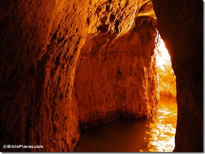
Hezekiah’s Tunnel
(photo source)
Share:

Some environmentalists are not happy with a plan to save the Dead Sea with a pipeline from the Red Sea.

Archaeology in Egypt has suffered from the political turmoil and resulting loss of tourist dollars.

Residents of Modi’in are protesting plans to build where someone else used to live a long time ago.

Seth Rodriquez provides insight into the Broken Wall of the Sluggard.

Rubén Gómez has a new website for his Spanish-speaking tour of Israel later this year.

The History Channel shares six “secrets” of King Tut.

In honor of Ehud Netzer, the Biblical Archaeology Society has made a collection of Ehud Netzer’s articles available for free, including the recent “In Search of Herod’s Tomb.” Click on each title to read.

The ASOR Blog provides a weekly roundup of stories in the broader world of archaeology.

HT: Jack Sasson

Share:

The Gezer Excavation Project includes a major regional survey under the direction of Eric Mitchell.

A preliminary report of the first five seasons (2007-2011) has now been published in Hadashot Arkheologiyot. Some excerpts:


Purpose: “The purpose of the project is to carry out a systematic high resolution archaeological survey of the region, within 1 km of Tel Gezer, and to locate and publish all features therein. This survey will aid in gaining a better understanding of the historical development of relationship between the ancient city of Gezer and its surrounding landscape.”


History: “The immediate vicinity of Tel Gezer has been investigated by R.A.S. Macalister who noted over 200 archaeological features within 1.5 km of the tell (Macalister 1912 III: Pl. VIII). In recent years, A. Shavit conducted a survey of the entire Gezer Map. Shavit noted that his survey was intensive but he was selective in the surveyed areas.”


Methodology: “To date, 1260 features have been recorded during the current investigations. Features are defined as any individual cultural element deposited on, built on, or carved into the landscape.

Therefore, with features such as winepresses, which include a basin, vat, channel, and cupmarks, each individual feature was added to the total and thus, the number of sites can be reduced significantly.”


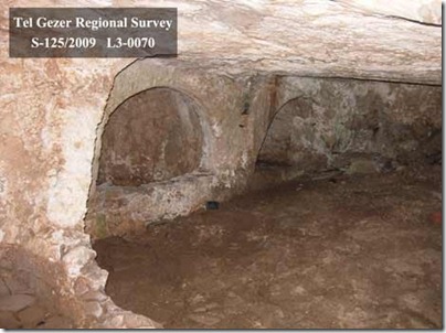
Tombs: “Forty-one tombs were accessible for interior survey. Seven basic categories of tomb type have been encountered during the survey. These include tombs with irregularly shaped interior plans (6), simple bench-style tombs (4), arcosolium or recessed bench tombs (5), a distinct simple double arcosolia type (5), loculus or kokhim tombs (9), tombs with multiple styles (3), and tombs that are incomplete, partially filled, or otherwise do not fit into the above categories (9).”


Surface Visibility: “While modern and old disturbances could have easily hidden the existence of tombs, caves, and presses where agricultural land now stretches, the ploughed fields and orchards now offer excellent surface visibility and provide ample opportunity to observe and collect pottery, tesserae, and chert flake scatters, which would otherwise have been obscured by dense brush.”


Conclusions: “The results of the 2007–2011 Tel Gezer Survey seasons have been encouraging in terms of both artifacts and features documented, as well as total area covered. At the current rate, it is estimated that two to three additional seasons will be necessary to complete surveying a 1 km radius around Tel Gezer. Our goal for the future is to publish a catalog of features within our survey area, as well as articles on the tombs and presses of Tel Gezer. At the end of the project, we will analyze all our GPS location data for features and artifacts from every season via mapping software. Using this data, we can construct a clearer understanding of distribution patterns for various features, as well as draw wider conclusions about the use of the land around the ancient city of Gezer.”

The full report includes five images. Check out the official website for information about joining the team.

gezer-tomb
View of arcosolia in Gezer tomb
Photo by Tel Gezer Regional Survey
Share: