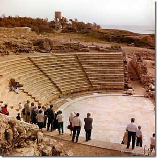
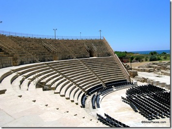
Visitors to ancient sites in Israel often wonder how much has been restored and how much is original. Sometimes there is a snaking black line that the restorers have placed just to answer this question. But oftentimes there is no such indicator, and the tourist may imagine that what he is seeing has stood intact since the biblical period. One site that I was long unaware of the degree of reconstruction was the theater of Caesarea. Constructed by Herod the Great, this theater was the location of the incident in Acts 12:19-24 where Herod’s grandson, Agrippa I, was struck down (see Josephus, Antiquities XIX.8.2). But much transpired between then and now, and the photo below gives an idea of the poor preservation of the upper seating area of the theater.
A friend recently wrote to ask if I knew how to get higher resolution digital images of the maps and reconstruction diagrams for the new ESV Study Bible. Upon investigating, I realized that he missed one crucial step (see below). But in the process, I was struck by the wealth of visual resources that are available to all who own a copy of this Bible. With the steps below, registered owners can get (what I’d call) medium-resolution images of everything in the Bible. For instance, you get:
- The City of Nineveh
- Jerusalem in the Time of David
- The Tabernacle (about 6 beautiful reconstructions)
- Solomon’s Temple
- Jerusalem in the Time of Solomon
- The City of Jericho
- Jerusalem in the Time of Hezekiah
- Zerubbabel’s Temple
- Jerusalem in the Time of Nehemiah
- The City of Babylon
- The Temple Mount in the Time of Jesus
- Galilean Fishing Boat
- Herod’s Temple in the Time of Jesus
- The Tomb of Jesus
- Herod’s Temple Complex in the Time of Jesus
- Plus a couple hundred maps and charts.
All you have to do is select the image and right-click to save.
The drawings seem to be 1200 pixels wide and the maps are approximately 1000 pixels on the long side. That’s excellent for computer or projector use. Here are the steps to access them (for registered users):
1. Go to http://www.esvstudybible.org/online
2. Select “Maps and Charts” on the top bar.
3. Scroll down and select desired image.
4. Within popup window, click graphic. This opens up the image by itself in a larger size. (If you skip this step, you’ll end up with a much lower-resolution image.)
5. Right-click image; “save image as” (or equivalent in a browser other than Firefox).
Then you can view the image on your screen, drop it into a PowerPoint, or print it for your wall. I checked with the publisher to make sure what I’m telling you is allowed and they stated that you may use these images for personal use (i.e., saved on your computer) or ministry use (i.e., projected for teaching purposes), but not reprinted in other materials or posted onto websites or blogs. (For questions or permissions, email Crossway.)
If you don’t own the Bible, you can see and download some free drawings, a map, and a city plan on their blog, plus a few at Amazon.
So for $32, you not only get a really fat book, you also get electronic access to 40 reconstruction diagrams plus 200 full-color maps. I know the market pretty well in this area and I’d suggest that you’re getting your money’s worth just from the digital images. It’s like the printed Bible is thrown in for free.
I use the printed Bible and the online Bible every week for reasons entirely other than what is listed above. You can see more of what keeps me coming back (print and digital) even though I have two shelves of other Bibles.
- Tagged Resources
Archaeologist Yosef Garfinkel discusses his discovery of the Khirbet Qeiyafa ostraca in a 2.5 minute video posted on youtube. There is a transcript in the right sidebar.
The website of the Tell es-Safi/Gath Archaeological Project has been thoroughly revised and updated. You can read about what has been discovered in previous seasons, as well as learn more about how to volunteer for the coming season. The website also includes a photo gallery and a virtual tour of the tell. Many of the images link to high-resolution versions.
HT: Paleojudaica and Aren Maeir
- Tagged Excavations, Shephelah
The Israel Antiquities Authority has reported the discovery of an ancient marble figurine. The bearded man may be a Roman boxer and is believed to date to approximately A.D. 200.
The figurine was used as a suspended weight together with a balance scale. This is probably the only find of its kind from excavations in the country.
A figurine (bust) made of marble depicting a miniature image of a bearded man’s head was discovered in the excavations that the Israel Antiquities Authority is conducting in the area of the Givati car park in the City of David, in the Walls around Jerusalem National Park.
According to Dr. Doron Ben-Ami and Yana Tchekhanovets, directors of the excavation at the site on behalf of the Israel Antiquities Authority, “The high level of finish on the figurine is extraordinary, while meticulously adhering to the tiniest of details. Its short curly beard, as well as the position of its head which is slightly inclined to the right, are indicative of an obviously Greek influence and show that it should be dated to the time of the emperor Hadrian or shortly thereafter (second-third centuries CE). This is one of the periods when the art of Roman sculpture reached its zenith. The pale yellow shade of the marble alludes to the eastern origin of the raw material from which the image was carved, probably from Asia Minor, although this matter still needs to be checked”.
The rest of the press release is here, and three photos may be downloaded in a zip file. The story is covered by Haaretz and the Associated Press. Reports of previous discoveries in this same excavation may be read here and here and here and here.
HT: Joe Lauer
- Tagged Discoveries, Jerusalem
Gary Byers of the Associates for Biblical Research has written a new article on the excavations of Tall el-Hammam, a site that has been identified as Sodom by its excavator, Steven Collins. The essay is a sensible review of the site’s history based on archaeological work and biblical data. I don’t find the Sodom identification compelling based on the present state of the evidence, but this does not detract from the value of the article. There is no doubt that Tall el-Hammam was an important site in the ancient world, and continued excavations there will no doubt be useful in revealing more of the region’s history. The article concludes:
In review, our site was a major city from earliest times. It may be one of the
oldest cities mentioned in the Bible, in the Table of Nations (Gn 10).
Maybe it was Sodom from those earliest days up to the time of Abraham, well over 2,500 years. Then, after its destruction in the Middle Bronze Age, and with no evidence of occupation for over 500 years, it may have been known as Abel Shittim (“meadow of the acacia trees”) at the time of Moses. During the Iron Age, a city was built on the upper tall, and it is a reasonable candidate to be the capital of Solomon’s twelfth administrative district, in sight of the Mount of Olives at Jerusalem, Solomon’s capital. In New Testament times, a new city arose around the base of the talls and may have been Abila or even Livias (Julias), the capital of Perea. Finally, our site may be one of the unnamed sites on the Madaba Map.
Whatever our excavations and research may eventually tell us, there is no question that Tall el-Hammam was an important site throughout the Biblical period. During each period of history, it stood as a quiet witness to some of the Bible’s greatest people and events.
- Tagged Excavations
Aren Maeir reported last week on an archaeological meeting in Beersheba that included eight presentations on recent research on the Philistines in Israel. Reports like this are so helpful in giving the public a sense of the progress being made in the field. Otherwise individual reports will appear in scattered journals or possibly an (over-priced) collection from a European publisher and be unknown by those with a general interest.
You can read his summary of the presentations, but I’ll just note here Pirhiya Nahshoni’s excavation of a small Late Bronze fishing village which included “imported Minoan, Mycenaean, Anatolian, Cypriote, Egyptian and other finds.” That’s quite a rich collection of imports. Maeir had previously praised the significance of this site:
Meanwhile, what she has published in her MA thesis is of utmost importance! This study has been largely overlooked, but deserved close attention from anyone dealing with the final stages of the LB and the early Iron I periods. For example, the fact that the site is abandoned at the end of the LB and not resettled in the early Iron I, is a nice example of the major changes that occured in the settlement pattern, trade relations, economic structure, etc., between the two periods. It would appear to support the “normative” explanation on the Sea Peoples/Philistine phenomemon, i.e. that it is not a continuation of the LB, but rather, a new, intrusive event(s).
Maeir concludes his post with a description of the rocket attack he experienced while in Beersheba.
- Tagged Discoveries, Lectures, Philistines
The BiblePlaces Blog provides updates and analysis of the latest in biblical archaeology, history, and geography. Unless otherwise noted, the posts are written by Todd Bolen, PhD, Professor of Biblical Studies at The Master’s University.
As an Amazon Associate we earn from qualifying purchases. In any case, we will provide honest advice.

