fbpx

Earlier this year I made a seven-day trip to Jordan to take photos. For the first time in my travels in the Middle East, I used a GPS. It worked well. If you’re planning to rent a car and travel around on your own, you might consider it as an option. Here is what I did.

1. I bought a GPS. The one I purchased was not the cheapest, but I was very happy with it.

2. I bought a map set for Jordan (for Garmin). This set actually includes all of the Middle East except Israel. If you need Israel, there’s one here. (Beware the very cheap ones; they are illegal copies.)

3. The most important part of the process is to identify the sites you plan to visit ahead of time. This is particularly important if you are planning to see lots of random tells that aren’t on the maps and that the locals may not be able to help you with.

3a. First, locate the sites of interest on Google Earth. This can be challenging, depending upon how obscure your sites are. If you have a reference source with coordinates, see A.D.’s post on how to convert them to GE points. You may find the Site Index for the Pictorial Library of Bible Lands helpful for its list of coordinates as well. If you are looking for a GE file (kml) of lots of biblical sites in Israel and/or Jordan, search on the web (though reliability varies).

3b. Then, export your chosen sites to a kml file (simple instructions here). Convert that to a format your GPS can read. You can do this at kml2gpx.com or similar sites. Then copy the converted file to your GPS (video instructions here).

That’s it. I would recommend you bring a map or two, just in case your GPS fails on the trip. (I packed my GPS in my carry-on luggage so it wouldn’t be “borrowed” by luggage handlers.) You might even consider bringing a backup GPS if funds allow. (And part of that question is also, how much would it be worth to you in the middle of your trip if your other failed?)

One other step I took, not knowing how the GPS would work, was to use the (now free) Google Earth Pro to print off high-quality images of the sites and their surroundings. I figured this might help me when the GPS map data was wrong or incomplete. Several times these print-outs came in handy.

image

I didn’t find every site I was looking for, but that wasn’t the fault of the GPS. Sometimes I had limited information in originally locating the site in GE. At other times, the site just seemed to disappear (as did Beth-jesimoth, in the midst of a quarrying operation). I missed a few sites because of rental car troubles, but I saw far more than if I had been at the mercy of a bus schedule or even a taxi driver. I also preferred this method to using a guide because most guides don’t like to pull out at 6 am and return after dark.

A few additional notes:

1. There are no good detailed maps for Jordan.

2. Don’t trust the time estimates your GPS gives you. The program data may be limited and it may
assume that you can drive 90 km/h down that narrow alleyway.

3. Sometimes the GPS gets it wrong. Sometimes you think you know better and you get it wrong.
You learn as you go, and it helps to have a flexible schedule.

4. Walking and taking a cab in downtown Amman (or Jerusalem or other major cities) beats driving.

5. Don’t be in such a rush that you don’t get to know the people. (Or, make sure the car breaks down in the right place.)

6. A newer book that is quite helpful in Jordan is Burton MacDonald’s Pilgrimage in Early Christian Jordan: A Literary and Archaeological Guide (Oxford: Oxbow, 2010).

7. Jordan is beautiful in March.

Macherus Roman siege ramp and camp from east, tb031415756
The Dead Sea from Macherus
Share:

Just posted: Preliminary Report of the 2015 Jezreel Expedition Field Season

A full schedule of speakers and topics for the Annual Bible and Archaeology Fest is now online. Eric Cline is the plenary speaker.

After the heat wave and brutal sandstorm, Israel this past week experienced lightning, hail, and flash floods. This is not typical September weather.


Near Eastern Archaeology‘s latest issue is devoted to “The Cultural Heritage Crisis in the Middle East.” It is available online for free to all.

Eisenbrauns has just released its fall catalog.

A new book: Distant Views of the Holy Land, by Felicity Cobbing and David Jacobson. 330 pages, 350 illustrations, $200. A free sample is available here.

Here’s more about Penn Museum’s new exhibit, “Sacred Writings: Extraordinary Texts of the Biblical World.”

This Wednesday, Sept 23, Brent Strawn of Emory University will give a lecture at Trinity Evangelical
Divinity School entitled “The Historical Psalms, Iconographically Considered.” The event will take place at 7:00 pm on Trinity’s campus, Hinkson Hall in Rodine Building. The lecture is free and open to the public.

Clashes on the Temple Mount have caused damage to Al Aqsa Mosque.

Aren Maeir is on the Book and the Spade talking about his excavations of Gath and the discovery of a large gate this season (part 1, part 2).

Egyptian security officials have ordered the shutdown of St. Catherine’s Monastery.

From ASOR: Can you pass this Sea of Galilee quiz?

The latest issue of Popular Archaeology includes articles on Gath and Magdala.

Ferrell Jenkins explains the significance of Mahanaim (mentioned 13x in the OT) and shares some photos.

HT: Agade, Charles Savelle, A.D. Riddle, Paleojudaica

Share:

For many years I have enjoyed taking students deep into the world of ancient Israel, exploring its land, its people, and its stories. One place that is always most rewarding is the era of Israel’s kings, for this terrain is little known and yet abounding with riches.

The chronology, however, can get people tied up real fast. That’s why I’m excited about a new
resource that maps everything out with clarity. The Regnal Chronology of the Kings of Judah and Israel: An Illustrated Guide puts every detail in its place, so with one glance you can figure out in any given year who is ruling, the king’s age and regnal year, and every extrabiblical synchronism. It truly puts everything at your fingertips.

chronology-900-850a-500

Chris McKinny has been developing this resource for many years while living, studying, and teaching in the Jerusalem area. Both the digital book and the e-poster reflect his passion for the subject, and they’re now available at an introductory price of $9.99 for the e-poster, $19.99 for the digital book (pdf), or $24.99 for both.

I encourage you to take a look. You can order it quickly and easily here. And we would appreciate it if you would tell friends, pastors, students, and teachers about it. This sort of resource is unique, and we believe there are many who will absolutely love it, if they know about it.

mckinny-poster500
Share:

This week’s sandstorm in Israel is the worst it has experienced since the nation was founded in 1948.

Air pollution in Jerusalem was 173 times higher than average. Carl Rasmussen shares a video showing how bad it was on the Mount of Olives.

What exactly is a 100-foot-deep shaft doing next to the Rockefeller Archaeological Museum in Jerusalem?

Andrew Bernhard posts on the End of the Gospel of Jesus’ Wife Forgery Debate.

Thieves in Galilee were caught removing a sixth century mosaic church floor in Gush Tefen.

The cisterns at Arad are now open to visitors.

Muslim “sentinels” protecting the Temple Mount from “sacrilege” have now been outlawed by Israeli police.

If your interest is in exotic shofars and what Jewish halakah has to say about it, Zoo Torah has a free pdf on the subject.

The BBC reports on six “lesser-known wonders of the ancient world,” including the site of Baalbek in Lebanon.

The Jerusalem Post Magazine reports on sinkholes around the Dead Sea. (At the moment of posting this, the link is not working. Perhaps it will return.)

ISIS is destroying ancient buildings in order to conceal evidence that they are looting for profit.

The Institute for Digital Archaeology plans to distribute 10,000 3-D cameras in the coming year in
order to document archaeological sites and objects in West Asia before they are destroyed.

A luncheon will honor James F. Strange at this ASOR meeting in Atlanta.

Ferrell Jenkins illustrates what David meant when he wrote about “a dry and weary land where there is no water.”

Did you know that the Upper Room is located directly above David’s Tomb?

The Dead Sea Scrolls scam at the California Science Center closed this week.

“The Manar al-Athar open-access photo-archive (based at the University of Oxford) aims to provide high resolution, searchable images, freely-downloadable for teaching, research, heritage projects, and publication. It covers buildings and art in the areas of the former Roman empire which later came under Islamic rule (e.g. Syro-Palestine/the Levant, Arabia, Egypt, and North Africa), from ca. 300 BC to the present, but especially Roman, late antique, and early Islamic art, architecture, and sacred sites.”

HT: Charles Savelle, Ted Weis, Agade, Joseph Lauer, Jared Clark

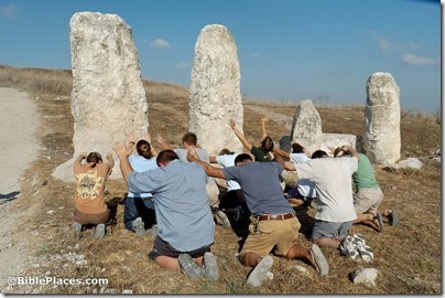
Our Facebook photo with the most clicks in the past week was the final one in our “holy rocks” series.

Gezer standing stones, bowing down, tb091405098
Standing stones at Gezer
Share:
(Post by A.D. Riddle)

On Thursday, October 1, at 7:15 pm, the Biblical and Theological Studies Department at Wheaton College will host a screening of the film Patterns of Evidence. After the film Daniel Block will moderate a panel discussion including Daniel Master and James Hoffmeier. The event will take place in Wheaton College’s Billy Graham Center 105, Barrows Auditorium. It is free and open to the public. Information about the event can be found here.

Share:
(Post by A.D. Riddle)


About five months ago, we wrote about (1) the series Royal Inscriptions of the Neo-Assyrian Period (RINAP) and (2) the importance of the Neo-Assyrian period for biblical history.

At that time we mentioned a few advantages to having the physical volumes over the digital versions at ORACC (The Open Richly Annotated Cuneiform Corpus), namely, the introductions to the texts and bibliography.

Since then, ORACC has been expanding the RINAP Online to include more resources. Now, you can find the following:

RINAP 1 = Tiglath-pileser III and Shalmaneser V

The same resources are made available for:

The following resources are provided for all three RINAP volumes:

The following volumes are in the pipeline:
RINAP 2 = The Royal Inscriptions of Sargon II
RINAP 5 = The Royal Inscriptions of Ashurbanipal, Aššur-etel-ilāni, and Sîn-šarra-iškun

In our piece, we listed all the RIM and RINAP volumes. They are also listed on this page.

HT: Grant Frame via Agade List

Share: