fbpx

The Baptist Press recently posted an article about the Middle Bronze II water tunnel at Tel Gezer. The excavation team is currently clearing out the tunnel and conducting a detailed study of it. Below is a picture of the entrance to the tunnel taken in 2004 by Todd Bolen. The tunnel begins to the left of where the man is standing and descends underground past the left side of the picture. (Recent pictures from inside the tunnel are posted with The Baptist Press article.)

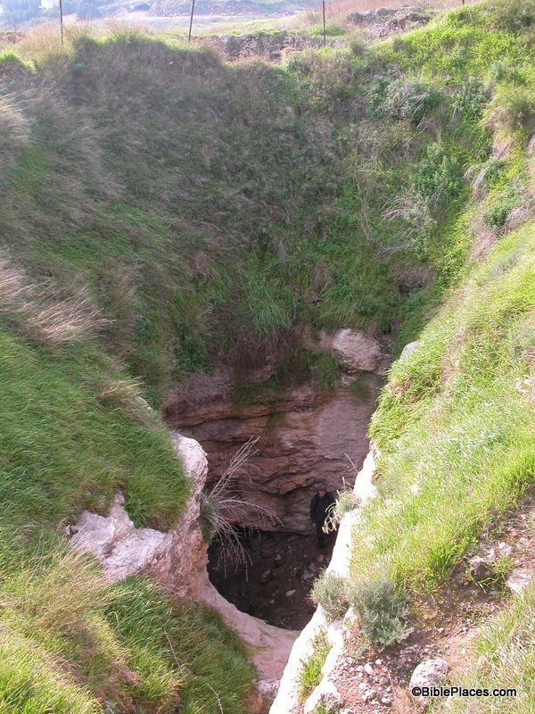
Here’s how the article describes the tunnel:

The challenge is excavating a large, rock-hewn water tunnel at Tel Gezer that is believed to have been carved out by Canaanites between 1800 and 1500 B.C. — around the time of Abraham. Tons of debris must be removed from the ancient tunnel before the real work can even begin. …

The Gezer system also is unusually large, measuring 12 feet wide by 24 feet tall, Parker noted. It is believed that the ancient people used donkeys to ferry water from the source to the surface. The width allowed two animals, loaded with jugs, to pass side by side. The height of the tunnel perplexes the expedition team, and they hope to find an explanation as they pursue the dig. …

Last summer the team began the arduous tasks of removing tons of rubble from the tunnel. During a three-week dig, they cleared 72 tons of dirt and rocks. Team members dug out the tunnel and put debris in large sacks which were hoisted out with a crane. Due to the 38-degree slope, Parker compared it to working on a steeply pitched roof.

The Middle Bronze II period was a time when the Canaanite city-states grew strong. Large public works were widespread in the region, such as city walls, massive earthen ramparts, and glacis (i.e., defensive slopes below the city walls). So the cooperation and organization needed to dig a water tunnel was relatively common during that period, but (as the article points out) elaborate water systems were not. Sophisticated water systems (such as the ones at Hazor, Megiddo, and Hezekiah’s Tunnel in Jerusalem) are more characteristic of Iron Age II cities.

Side Note: The article mentions that 1800 to 1500 B.C. is “around the time of Abraham.” The date of Abraham’s lifetime is a debated issue related to the “Early Date vs. Late Date” controversy about the Exodus. The article apparently assumes a Late Date position. My personal conviction (and that of Todd Bolen) is that the Early Date position is the correct one, which would place Abraham’s lifetime at approximately 2150 to 2000 B.C. If this is correct, then construction of the Gezer water tunnel would have occurred during the time of Israel’s 430-year sojourn in Egypt.

The Baptist Press article can be found here. Details about the dig this summer can be found here. The excavation’s homepage can be found here.

HT: Joseph I. Lauer

Share:

While conducting research for my dissertation (The Arsenal of the Hebrew Kings and Their Neighbors), I was able to follow up on a question that my advisor had once asked me: How were slings used in antiquity? In other words, what technique was used to generate the centrifugal force needed to propel the stone across the battlefield?

In general, the modern assumption is that the sling was twirled in a horizontal circle over the archer’s head. For example, Rivka Gonen in her 1975 book Weapons of the Ancient World states, “A stone was placed in the pocket [of the sling] and then swung round and round above the head; when sufficient centrifugal force had been generated, one of the thongs was released, discharging the stone at a high speed towards its distant target” (p. 42).

This technique was apparently used by the Egyptians in the 12th century B.C. There is a famous relief at Medinet Habu that depicts a battle between the Egyptians and the Sea Peoples during the reign of Rameses III. Within this relief, there are a handful of slingers. Positioned high in the “crow’s nest” of the Egyptian ships, these slingers are depicted in the act of twirling their slings over thier heads, as shown below. (Image taken from Nelson, “The Epigraphic Survey of the Great Temple of Medinet Habu,” in Medinet Habu–1924-28, p. 27). This also seems to be the technique used by a slinger depicted in a relief from Tell Halaf in northwestern Mesopotamia that dates to the 10th or 9th century B.C.


Egyptian Slinger from the Medinet Habu Relief

However, the slings in the reliefs of the Assyrian kings Sennacherib (705-681 B.C.) and Ashurbanipal (669-629 B.C.) are not depicted horizontally. In general, they are depicted as hovering vertically (or almost vertically) over the head of the slinger. An example of such an Assyrian slinger on the Lachish Relief can be seen here (see Fig. 30a). Elsewhere on that relief, a Judean slinger is also depicted with his sling in this position. When slingers use the twirling method described above, the sling is never in such a position, so another method must be proposed.

It would appear that during the late Iron Age the slings of Assyrians and Judeans were used by swinging the whole arm in a wide, vertical circle. Based on the consistent angle of the slings in various Assyrian reliefs, it appears that the slinger’s arm was swinging forward at the top of the circle. The slinger’s arm is always depicted as vertical or almost vertical, and the sling (when it is not depicted as directly in line with the arm) is almost always depicted as trailing slightly behind the arm, away from the slinger’s front side. So it seems that after the slinger loaded his weapon, he would move his arm down and backwards in a sweeping motion and would swing the sling vertically over his head. (Imagine a professional baseball pitcher using a sling to pitch a ball and you have the general idea.) This motion may have occurred only once or may have been repeated several times to build up momentum. At the crucial moment, one of the thongs was released and the projectile was launched toward its target.

So the archaeological evidence indicates that there were at least two slinging techniques used in the ancient Near East: a horizontal rotation over the slinger’s head, and a vertical rotation similar to an overhand pitch. If we stop to think about it, it should not surprise us that different slinging techniques developed at different times and in different places. For a tool as simple as a sling and stone, some diversity in its use was bound to occur.

Share:

This isn’t exactly breaking news, but I did not find any other blogs that had written about it, and it seems worthy of mention.

Back in September 2007, Turkish Daily News (now known as The Hürriyet Daily News and Economic Review) reported that operations to clear the land mines near the site of Carchemish had commenced. At the time, it was estimated the clean-up would take about one-and-a-half years. Todd mentioned it here.

As a follow-up to this story, it was reported last December in Today’s Zaman that the mines had been cleared and the land was now in the process of being turned over to the city. After bidding for the mine-clearing project, work actually commenced in March 2010. Three hundred days later, it was complete. Mine-sniffing dogs were used in the initial stages, and to avoid damaging antiquities, the mines were removed to another location for detonation (usually, mines are detonated on the spot). Now that the mines have been cleared, archaeologists will begin “serious and long-term” excavations, which it is hoped will attract tourism.

The site of ancient Carchemish is cut by the modern Turkey-Syria border. The citadel and inner town are located within Turkey, but most of the outer town is located in Syria. On the Turkish side is the modern village of Karkamiş and on the Syrian side is the village of Jerablus. As part of Turkey’s attempts to open up trade with its neighbors, plans are underway to open three new border crossings with Syria by 2012, one of which will be located at Karkamiş.


For an account of the earlier excavations conducted by Sir Leonard Woolley, see here.

Carchemish from the northwest, view of citadel and inner town wall.

Carchemish citadel from the northwest.
Share:
In 2009, I had the privilege of sitting under Anson Rainey in his second-to-last tour of duty at Jerusalem University College (formerly known as the Institute of Holy Land Studies) where he taught for over 50 years.  I would always approach that class with great expectation – for I knew that when Prof. Rainey began to speak the scent of long-dead ANE academic battles would soon fill my nostrils.  A course with a giant like Rainey was as much about learning the methodological history of the discipline of Historical Geography (as well as the always entertaining “tit for tat” – often with the likes of Albright and the “accursed” Yadin), as it was about learning the actual historical data.

Those of you who knew Prof. Rainey – know that he was never shy of conflict, rather he invited it, he was almost always absolutely certain of his own view (the examples are limitless – Via Maris: Road to Nowhere, Bethel=Beitin, Shimron=Ghost Word – just to name a few…).  However, beneath the facade of unabashed directness rested a teacher that was always willing to both hear and offer helpful advice to student’s thoughts and questions about the ANE and even their own lives.  He will be greatly missed.

Taken March 1968 – part of the Views that Have Vanished Collection

The following is some information regarding Anson Rainey’s final resting place and the events leading up to his death from Emanuel Hausman the Chairman of Carta.

Anson was hospitalized on his eightieth birthday. A few days later he was diagnosed with pancreatic cancer, that had advanced far beyond the possibility of surgical intervention. Anson refused alternative treatments such as radiation, chemotherapy or life prolonging medication. Resigned to his fate, he asked for some letters to be written and messages to be sent to friends. His one wish was  that his life’s ambition, the collection of The El Amarna Letters, be completed and brought to publication.

Anson passed away on Saturday 2/19/2011 and according to his last wish was buried at Barkan overlooking the hill country of Samaria that he loved so much. Attended by family and many of his friends his funeral took place in weather as turbulent as his life and eponymously RAINY.

You may have heard this from Anson before but he often  joked that the first thing on facing GOD was to ask Him  how he pronounced  YHWH -.- May he rest in peace.

Share:

About four months ago, Todd announced the publication of a new guidebook for Turkey entitled Biblical Turkey: A Guide to Jewish and Christian Sites of Asia Minor, by Mark Wilson (Ege Yayınları, 2010). What prompts this review is the news that the book can now be ordered from Amazon.com and sells for $39.95.

Biblical Turkey
is not a guidebook like Lonely Planet or Rough Guide—it does not tell you where to find accommodations or the best places for affordable dining. What Biblical Turkey does do, however, is give you just about all the archaeological and historical information you will need for numerous sites in Turkey. The book includes every well-known and lesser-known site which is mentioned in the Bible, but it includes much more than that. As such, this is rich resource, whether you travel to Turkey or not (though, I recommend that you take a trip at some point).

What sets this book apart from A Guide to Biblical Sites in Greece and Turkey, by Fant and Reddish (Oxford Univ. Press, 2003), is its comprehensiveness. Fant and Reddish did not include a number of sites that are mentioned in the Bible, such as Cnidus, Carchemish, and Harran. Wilson includes all of these as well as many other important archeological sites which are not mentioned in the Bible, such as Van Kalesi (ancient Tushpa, the capital of Urartu), Gordium (the capital of Phrygia), Kanesh/Kültepe (the Old Assyrian trading colony), and Nemrut Dağ (the mausoleum of Antiochus I of Commagene).

Nemrut Dağ west terrace, toppled heads from colossal statues.

Biblical Turkey is organized by five regions, beginning in eastern Turkey and working westwards. Each chapter begins with historical and geographic descriptions of ancient regions and provinces (e.g., Cappadocia, Galatia) and then covers the ancient cities within that region. For each region and city, biblical references are listed, a historical summary is given, and the relevant inscriptions and archaeological remains are described. Though written in a non-technical style, the text betrays a depth of technical knowledge in these areas which is quite impressive. Nearly every two-page spread is graced with a carefully selected photograph of the site, an architectural element, or an inscription, which is helpful for understanding the text. Finally, for many sites, Wilson provides a title or two for “further reading.” Most of the titles he suggests are guides available at the site itself, often written by the archaeologists, and published in Turkey. These can be difficult to obtain, but it is helpful nevertheless to have this information. (For those who are desperate enough to pay the stiff shipping charges, many of the titles can probably be purchased at Zero Books.)

I find several other features of Biblical Turkey helpful. The Turkish names are provided alongside the more common English names which facilitates navigating by maps and road signs. The book is also generously furnished with site plans and sidebars. The sidebars come in three types: “side trip” boxes provide brief descriptions of lesser-known sites you may want to add to your trip if you have spare time, “in-site” boxes give more background detail (e.g., a New Testament timeline, the seven ecumenical councils, or ancient travel on the Mediterranean), and “ancient voice” boxes discuss ancient textual sources in greater detail.

Maybe I’m gushing now, but I wish all guidebooks were written like this one. A lot of thought and research went into the content and its organization. Turkey is a vast country with many fascinating things to see and study. With this book in hand, no longer will so much of it go unnoticed.

FURTHER NOTE: Mark Wilson is the director of Seven Churches Network and Asia Minor Research Center. You can read more about Mark here. Leen Ritmeyer reviewed and recommended the book here.

Share: