Eisenbrauns has announced a new book by Anson Rainey entitled Teaching History and Historical Geography of Bible Lands: A Syllabus. Few details about the publication are available beyond its release date in December. Rainey taught a popular course in advanced Historical Geography for decades at the Institute of Holy Land Studies (now Jerusalem University College). A lifetime of research culminated in The Sacred Bridge, the most detailed resource on the subject ever written. I look forward to his latest contribution.
Ehud Netzer, an Israeli archaeologist renowned for his excavations of projects of King Herod, has passed away in Jerusalem following a fall at Herodium a couple of days ago. Limited details are posted at the blogs of Jim West, Menachem Mendel, and Aren Maeir, as well as the Jerusalem Post.
His fall was reported today in the Hebrew press here, here, and here. Netzer excavated at Herodium, Masada, Caesarea, Jericho, and in Jerusalem. His recent work, The Architecture of Herod, the Great Builder, is an excellent survey that makes available to the public the decades of his research. His death is a great loss to many. May his family and friends be comforted.
HT: Joe Lauer
- Tagged Herod's Tomb
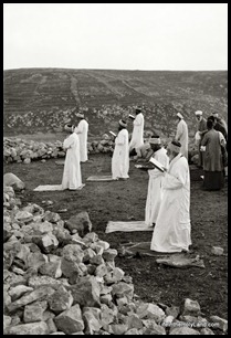
The Samaritan calendar differs from the Jewish calendar, and their celebration of the Feast of Tabernacles (Sukkot) began last week. Haaretz has a brief article about the observance, along with the notice that there are 712 living Samaritans (not “about 500” or “about 600,” as I’ve always heard, but “712”).
The Samaritans, members of an ancient sect closely associated to Judaism, marked the holiday of the Tabernacles, or Sukkot, on Friday.
Followers of the religion held an annual pilgrimage ceremony on Mount Gerizim, the sect’s holiest site, near Nablus.
Though the Samaritans numbered well over one million in late Roman times, there are now only 712 remaining members, who live mostly on Mount Gerizim and in Holon.
The newspaper has a gallery of six photos, but you’ll do better to head over to the Denver Post, which has beautiful images of previous Samaritan and the Jewish celebrations. The Samaritan community also has a page with video (Hebrew) about the event. China View has even more information about the Samaritan community and Sukkot.
Samaritan prayers on Mount Gerizim
This photo is from the Traditional Life and Customs volume of The American Colony and Eric Matson Collection (Library of Congress, LC-matpc-01846).
HT: Joe Lauer
- Tagged American Colony Photos, Samaria
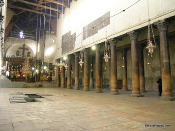
The Church of the Nativity in Bethlehem was built in the middle of the 6th century, making it more than 1400 years old. Unlike Jerusalem’s Church of the Holy Sepulcher, it escaped the Persian destruction in 614 and the Egyptian attack in 1009. The church not only suffers from age, but from the inability of its occupants to cooperate with each other. But now the Palestinian Authority has announced plans to renovate the church. From the Associated Press:
The Palestinian government announced Monday it is planning an ambitious restoration project for the ancient church that marks the traditional birthplace of Jesus, an important Christian site that draws millions of visitors.
The renovation of Bethlehem’s Church of the Nativity is expected to take several years and millions of dollars, according to Ziad Bandak, an official overseeing the restoration.
Bandak said this is the first comprehensive restoration project on the church since it was completed in the fourth century. He said the roof, pillars and mosaics in the church all need work.
“Rain leaking in has caused great damage to all of those, which led us to move quickly to repair the damage,” Bandak said, adding that the project would also aim to fix general wear and tear on the centuries-old church.
The fortress-like church, built in the classic style with a long central area under a basilica lined with columns on both sides, is dark and damp. The main Christmas event, the Midnight Mass, is celebrated in the 19th century St. Catherine’s Church next door to the Church of the Nativity.
The Palestinian government has appealed to European and Arab nations to help fund the project, Bandak said. He said the three churches that administer sections of the church have agreed to the project. Officials from the Latin, Greek and Armenian churches could not be reached for comment. Their rivalries have often led to fistfights between monks at the holy site.
The full story is here. For modern photos of the church, see this Pictorial Library volume. For historic black-and-white photos, see this American Colony CD.
Church of the Nativity in Bethlehem
From a story posted by Southwestern Baptist Theological Seminary:
Less than a year after acquiring three fragments of the Dead Sea Scrolls, Southwestern Baptist Theological Seminary in Fort Worth, Texas, has added three more biblical fragments, making it the largest collection of an institution of higher education in the United States. The new fragments were obtained from a private collector in Europe through the generous gift from a friend of the seminary. “The acquisition constitutes another significant milestone in the development of our programs in biblical studies and archaeology,” said Paige Patterson, president of Southwestern. “We are especially grateful for the friends of Southwestern who have made these acquisitions, as well as three other fragments, possible and for Mrs. Patterson and Candi Finch who worked so tirelessly to get them to Fort Worth.” The set of six fragments is one more than the set owned by Azusa Pacific University near Los Angeles, which acquired five pieces in 2009. The Oriental Institute at the University of Chicago also owns a fragment. Steven Ortiz, associate professor of archaeology and biblical backgrounds and director of the Charles D. Tandy Archaeology Museum at Southwestern, noted that having one fragment would be just as important as owning six. “It is not a race to see who can collect the most fragments,” Ortiz said. “The goal is to get these out of the hands of private collectors and make them available to the public, especially scholars. […] Early analysis shows the new fragments include portions of Deuteronomy 9:25–10:1, Deuteronomy 12:11-14, and Psalm 22:4-13. Psalm 22 is known as a prophetic messianic psalm that describes the brutality of Jesus’ death 1,000 years before he was crucified.
The full story is here.
Stephen Gabriel Rosenberg has written a summary of major archaeological stories in September.
Aren Maeir critiques an article in the current issue of BASOR in which three geologists argue that
Hezekiah’s Tunnel took about four years to dig and was constructed not by Hezekiah but by his son Manasseh.
Leen Ritmeyer has just released “The Ark of the Covenant: Its Journey from Sinai to Jerusalem” digital image collection. I’ve used a number of these images from the slide set over the years, but now Leen writes that so much has been added that the CD is “an entirely new presentation.”
I received some criticism for daring to suggest that last week’s 60 Minutes report on the excavations in the City of David would be one-sided. But according to this eight-point critique by CAMERA, I was right. Another website responds to the claim that there is “no evidence” of King David in
Jerusalem.
Carol Meyers will be lecturing this week in Fort Worth. Her title is “Holy Land Archaeology: Past Meets Present” and tickets are $20. Details are here.
Claude Mariottini points out National Geographic’s slideshow on “12 Ancient Landmarks on Verge of Vanishing.” The photo of Nineveh is striking, but I can’t agree with the inclusion of Hisham’s Palace (Jericho) in the list. It is surprising to me that the description of the ruins of Famagusta in Cyprus does not mention the city’s ancient name, Salamis. Barnabas and Saul (Paul) landed here on Paul’s first missionary journey (Acts 13:5).
The photograph in the blog header was taken twenty years ago this week. I was with a group of students from the Institute of Holy Land Studies excavating with Amihai Mazar at Tel Beth Shean.
Even in late October that place is hot!
- Tagged Jerusalem, Lectures, Resources, Weekend Roundup
Search
About the BiblePlaces Blog
The BiblePlaces Blog provides updates and analysis of the latest in biblical archaeology, history, and geography. Unless otherwise noted, the posts are written by Todd Bolen, PhD, Professor of Biblical Studies at The Master’s University.
Subscribe
Tags
10th Century
American Colony Photos
Analysis
Antiquities Trade
Dead Sea
Dead Sea Scrolls
Discoveries
Egypt
Excavations
Forgery
Galilee
Greece
Holidays
Israel's Coast
Italy
Jerusalem
Jezreel Valley
Jordan
Jordan Rift
Judah
Lebanon
Lectures
Mediterranean Islands
Mesopotamia
Museums
Negev
New Exhibits
Persia
Philistines
Photo Resources
Picture of the Week
Pseudo-Archaeology
Resources
Sad News
Samaria
Shephelah
Syria
Technology
Temple Mount
Tomb of Jesus
Tourism
Travels
Turkey
Weather
Weekend Roundup
Links
Notice
As an Amazon Associate we earn from qualifying purchases. In any case, we will provide honest advice.

