Chris McKinny correctly identified Where on Google Earth 73 as Jarmuth/Yarmuth, and he is hosting the latest edition on his blog. Give it a look!
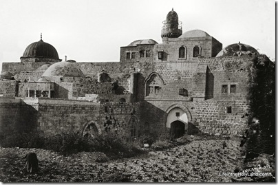
I think that for a certain subset of this blog’s readers, photo challenges are enjoyable. I’ll tell you a little and you can tell me the rest. This photo is part of the Jerusalem volume of The American Colony and Eric Matson Collection and it was taken in approximately 1900.
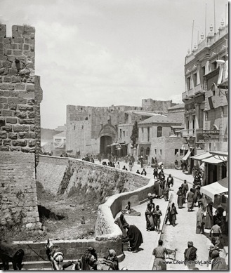
The best answer in the comments below wins a free copy of the Jerusalem CD (or your choice of another if you already have it). An important part of the answer is why it is impossible to take this same photo today.
- Tagged American Colony Photos, Challenge, Jerusalem
Recently a friend alerted me to a discussion online about major renovations to be started soon in the vicinity of Jaffa Gate. Among other things, this will close the gate off to vehicular traffic. If they dig anything up, chances are very high that they’ll find something of significance, which will slow their progress down even further. A source in Jerusalem relates the following:
1. The gate is being closed to car traffic due to road renovations.
2. They may leave one lane open for one-way traffic.
3. The gate is supposed to close soon after Succot (which ended a few days ago).
4. A Muslim policeman “who isn’t trustworthy” said that the gate would NOT reopen ever.
5. Shop owners are concerned about how they will receive supplies.
This is not the first time the authorities have done major work on the road here.
 Jaffa Gate area from east, with Crusader moat of Citadel visible in foreground. Date of photograph: 1898-1907. From the new Jerusalem CD.
- Tagged American Colony Photos, Jerusalem, Then and Now
Brian Janeway has written on “New Discoveries Relating to the Apostle Paul” at the Associates for Biblical Research blog. The focus of the article is the recent analysis of the alleged tomb of Paul, but he also comments on some related finds.
Eric Cline has posted a good primer at Bible and Interpretation on the all-important 10th century BC debate in biblical archaeology. In about ten minutes of reading, you get a number of good insights into the nature of the debate and the archaeological discipline as a whole. The article is adapted from his new book, Biblical Archaeology: A Very Short Introduction (168 pages; $9 at Amazon).
I mentioned previously the Old Testament version of the Zondervan Illustrated Bible Backgrounds Commentary, edited by John H. Walton and available in 5 volumes in November ($157 at Amazon, plus shipping surcharge). Chris Heard notes that the Genesis commentary is now available for reading on Scribd through the month of October.
Logos has a new pre-publication special of 19 volumes in a “History of Israel Collection.” You have to qualify just what a collection with that title means, because it is not the essential works on the subject. Rather these are volumes from the Library of Hebrew Bible/Old Testament Studies series published by Sheffield and T. & T. Clark. In other words, these are highly specialized, very expensive books. The collection is now available for $300 ($16/volume), which is about the cost of any two volumes. (A quick search at Amazon found Banks for $180, Wood for $25, McNutt for $50, Grabbe for $216, and Younger [not Youger] for $251). If you want it, buy it now, before the price jumps to $1300.
Eisenbrauns has a terrific sale this weekend on Shimon Gibson, Jerusalem in Original Photographs, 1850-1920. Gibson not only had access to some rare photographs, but his knowledge of the subject is extraordinary. Only $15 at Eisenbrauns. ($48 at Amazon)
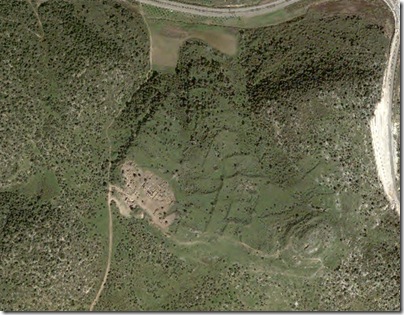
I correctly identified Heather’s choice of Hippos (Sussita), Israel in the latest round of “When on Google Earth,” and that gives me the privilege of challenging my readers to identify this site and its major period of occupation in the comments below.
The rules of When on Google Earth are as follows:
Q: What is When on Google Earth?
A: It’s a game for archaeologists, or anybody else willing to have a go!
Q: How do you play it?
A: Simple, you try to identify the site in the picture.
Q: Who wins?
A: The first person to correctly identify the site, including its major period of occupation, wins the
game!
Q: What does the winner get?
A: The winner gets bragging rights and the chance to host the next When on Google Earth on his/her own blog!
You can follow along on the Facebook group. Here is a list of previous sites and winners:
| # | Host: | Victor: | Site: | Period: |
| 1 | Shawn Graham | Chuck Jones | Takht-i Jamshid / Persepolis terrace, Iran | Achaemenid period |
| 2 | Chuck Jones | PDD | Church of Saint Simeon at Qalat Siman, Syria | 5th-6th c. CE |
| 2.1 | Chuck Jones | Paul Zimmerman | Qal’at al-Bahrain | 16th c. CE |
| 3 | Paul Zimmerman | Heather Baker | Baraqish (Yathill), Yemen | Minaean (1st millennium BCE) |
| 4 | Heather Baker | Jason Ur | Mohenjo Daro, Pakistan | ca. 2600-1900 BCE |
| 5 | Jason Ur | Dan Diffendale | Monte Albán, Oaxaca, Mexico | 1st-5th centuries CE |
| 6 | Dan Diffendale | Claire of Geevor Mine | Segontium, Caernarfon, Wales | 77ish to about 390 CE |
| 7 | Claire of Geevor Mine | Ivan Cangemi | Carn Euny, UK | ca. 500 BCE-100 CE |
| 8 | Ivan Cangemi | Southie Sham | Monks Mound (Cahokia), IL, USA | fl. 1050-1200 |
| 9 | Southie Sham | Dan Diffendale | Gergovia, France | fl. 1st c. BCE |
| 10 | Dan Diffendale | Dorothy King | Kastro Larissa/Argos, Greece | ca. 1100 CE |
| 11 | Dorothy King | Daniel Pett | Utica, Tunisia | C8th BCE– C2nd CE |
| 12 | Daniel Pett | Neil Silberman | Caesarea Maritima, Israel | 1st century CE–Present |
| 13 | Neil Silberman | Chuck Jones | Graceland, Memphis, TN, USA | 1939 CE–Present |
| 14 | Chuck Jones | Aphaia | Bam Citadel, Iran | pre-C 6th BC–C19thCE |
| 15 | Aphaia | Daniel Pett | Myrina, Lemnos, Greece | Classical Greek–present |
| 16 | Daniel Pett | Paul Barford | Dambulla Cave Temple, Sri Lanka | 1st century BCE |
| 17 | Paul Barford | Scott McDonough | Rosetta (Rashid), Egypt | Ptolemaic, Mamluk |
| 18 | Scott McDonough | Lindsay Allen | Ani, Turkey | Medieval, C10th-14th CE |
| 19 | Lindsay Allen | Heather in Vienna | South Shields, England, UK | Roman Imperial |
| 20 | Heather | Scott McDonough | Suomenlinna/Sveaborg fortress, Finland | 1748-present |
| 21 | Scott McDonough | Chuck Jones | Derbent, Republic of Dagestan | Sasanian-present |
| 22 | Chuck Jones | Paul Barford | Amphitheatre of Aquincum, Hungary | Roman |
| 23 | Paul Barford | Geoff Carter | The Cursus, (Stonehenge) Wiltshire | Neolithic |
| 24 | Geoff Carter | Ferhan Sakal | The Heuneburg, South Germany | Iron Age |
| 25 | Ferhan Sakal | Lindsay Allen | Sura, Syria | Roman |
| 26 | Lindsay Allen | Andrea Kay | Bannerman Castle, Hudson River, US | C20th |
| 27 | Andrea Kay | David Powell | Taposiris Magna, Alexandria, Egypt | C1st BCE |
| 28 | David Powell | Billy | Ross Abbey, Galway, Ireland | Medieval |
| 29 | Billy | Geoff Carter | Great Zimbabwe, Africa | C11th – 14th CE |
| 30 | Geoff Carter | Heather | Elsdon Castle, England | C11th – 12th CE |
| 31 | Heather | Geoff Carter | Volubilis, Morocco | Roman |
| 32 | Geoff Carter | Paul Barford | Su Nuraxi, Barumini, Sardinia | C15th – 6th BCE |
| 33 | Paul Barford | Ferhan Sakal | Arkona, Germany | Medieval |
| 34 | Ferhan Sakal | Heather | Arslantepe, Turkey | Chalcolithic – Byzantine |
| 35 | Heather | Ferhan Sakal | Mahabodhi Temple Complex, India | 3rd century B.C. – 6th CE |
| 36 | Ferhan Sakal | Billy | Borobudur, Buddhist shrine, Indonesia | 9th century B.C. – 6th CE |
| 37 | Billy | Ferhan Sakal | Browns Island, New Zealand | c. 13th century – 1820 |
| 38 | Ferhan Sakal | Andrea Kay | Bat, Al-Khutm and Al-Ayn, Oman | 3rd millennium B.C. |
| 39 | Andrea Kay | Matt B. | Serabit el-Khadim, Egypt | 2nd millennium B.C. |
| 40 | Matt B. | Andrea Kay | Valsgärde grave field, Sweden | Swedish Vendel /Iron Age |
| 41 | Andrea Kay | Lindsay Allen | Siwa oasis, Egypt | fourth century B.C. -Roman |
| 42 | Lindsay Allen | David Gill | Castle of Pont Steffan, Wales, UK | Medieval |
| 43 | David Gill | Nigel | Hay Castle, Wales, UK | 12th century |
| 44 | Nigel | Heather | Olympos, Turkey | Hellenistic – Roman |
| 45 | Heather | Ferhan Sakal | Carnuntum, Austria | Roman |
| 46 | Ferhan Sakal | Troels Myrup | Knossos, Greece | Bronze Age |
| 47 | Troels Myrup | Alun Salt | Aggersborg, Denmark | Viking |
| 48 | Alun Salt | Geoff Carter | Marsala, Sicillia. | Punic/Roman |
| 49 | Geoff Carter | Matt B | Springfield Lyons, UK | LBA (/Saxon) |
| 50 | MattB | Geoff Carter | Kalkriese in Osnabrück, Germany | Roman |
| 51 | Geoff Carter | Ferhan Sakal | Grimes Graves, Norfolk, UK | Late neolithic |
| 52 | Ferhan Sakal | Oliver Mack | Heraqla, ar-rashid,syria | Late C8 CE |
| 53 | Oliver Mack | Matt B | Welzheim, Germany | Roman |
| 54 | Matt B | Geoff Carter | Birka, Sweden | Viking |
| 55 | Geoff Carter | Heather | Nemrut Dagi, Turkey | C1 bce |
| 56 | Heather | Geoff Carter | Choirokoitia, Cyprus. | Neolithic |
| 57 | Geoff Carter | Jaime | Woodhenge, UK | Late Neolithic |
| 58 | Jaime | Geoff Carter | Gorgora Nova, Ethiopia, | C17th (CE). |
| 59 | Geoff Carter | Nathan T.Elkins | Firouabad, Iran | C3rd CE |
| 60 | Nathan Elkins | Paul Barford | Portus, Italy | Roman |
| 61 | Paul Barford | Heather | Delos, Greece | Classical-Hellenistic Greek |
| 62 | Heather | Geoff Carter | Gordion, Turkey | 1500-700 BCE |
| 63 | Geoff Carter | CFeagans | Vix, France | 6th-5th C BCE |
| 64 | CFeagans | Alun Salt | Newark Great Circle, OH | 100 BCE |
| 65 | Alun Salt | Eloy Cano | Agra, India | 1556-1658 |
| 66 | Eloy Cano | Troels Myrup | Göbekli Tepe, Turkey | 10-8th millennium BCE |
| 67 | Troels Myrup | Heather | Kanhave canal, Samsø, Denmark | 8th c. CE/Viking |
| 68 | Heather | Troels Myrup | Butrint, Albania | 10th c. BCE-18th c. CE |
| 69 | Troels Myrup | Paul Zimmerman | Birketain, Jordan | Roman |
| 70 | Paul Z. | Oliver Mack | Cueva de Menga/Viera, Spain | 3rd mill BCE |
| 71 | Oliver Mack | Heather | Dur-Kurigalzu, Iraq | 14th-12th c BCE |
| 72 | Heather | Todd Bolen | Hippos, Israel | Roman-Byzantine |
- Tagged Challenge
Search
About the BiblePlaces Blog
The BiblePlaces Blog provides updates and analysis of the latest in biblical archaeology, history, and geography. Unless otherwise noted, the posts are written by Todd Bolen, PhD, Professor of Biblical Studies at The Master’s University.
Subscribe
Tags
10th Century
American Colony Photos
Analysis
Antiquities Trade
Dead Sea
Dead Sea Scrolls
Discoveries
Egypt
Excavations
Forgery
Galilee
Greece
Holidays
Israel's Coast
Italy
Jerusalem
Jezreel Valley
Jordan
Jordan Rift
Judah
Lebanon
Lectures
Mediterranean Islands
Mesopotamia
Museums
Negev
New Exhibits
Persia
Philistines
Photo Resources
Picture of the Week
Pseudo-Archaeology
Resources
Sad News
Samaria
Shephelah
Syria
Technology
Temple Mount
Tomb of Jesus
Tourism
Travels
Turkey
Weather
Weekend Roundup
Links
Notice
As an Amazon Associate we earn from qualifying purchases. In any case, we will provide honest advice.

