fbpx

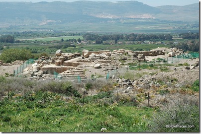
Today visitors to Capernaum are impressed by the white limestone remains of an ancient synagogue. 

Archaeological excavations indicate that this synagogue was built over the remains of an earlier synagogue dating from the time of Jesus.  Thus we can say with some measure of confidence that this is the place where Jesus healed the demon-possessed man (Mark 1:21-28) and preached the sermon on the bread of life (John 6:25-59).

Capernaum synagogue from Peter's house, tb060105618

Capernaum synagogue, view from Peter’s house, present day

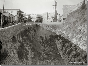
Visitors may not be aware that the synagogue did not survive in this condition since ancient times. 

The photograph below shows what the synagogue looked like in the early 1900s.  The staircase in the foreground of the photo below is on the far right (middle) of the photo above.

Capernaum, ruins of synagogue, mat10654sr

Capernaum synagogue, early 1900s

The second photograph is one of 600 high-resolution images in the new Northern Palestine CD, volume 1 of The American Colony and Eric Matson Collection. Photo: Library of Congress, LC-matpc-10654.

Share:

The ground-breaking work of the Palestine Exploration Fund in the 1800s continues to be a most useful source of information to scholars today.  I mentioned recently the online availability of many of the volumes of the Survey of Western Palestine, and a few years ago I created an electronic version of the Survey of Western Palestine Maps.  But the Palestine Exploration Fund archives contain much that has never been published, and yesterday Israeli Prime Minister Benjamin Netanyahu visited the offices in London.  From the Jerusalem Post:

Netanyahu, who mentioned the visit during his press conference with Brown, waxed poetic about it at a briefing with Israeli reporters, enthusing over the organization’s collection of maps, pictures and documents of Palestine dating back to the mid-19th century. "This is a treasure, it is something you all must see," he told reporters, as he kept returning to the subject and talking about the archival information there, and about the knowledge of the geography and topography of pre-state Israel housed in that building. The PEF was founded in 1865 and is the oldest organization in the world created specifically for the study of the Levant, the southern portion of which – as the organization’s literature makes clear – was conventionally known as "Palestine." The organization publishes an internationally respected journal, the Palestine Exploration Quarterly, and brings the latest archaeological findings and research to the public in a series of regular lectures. The PEF archives houses some 40,000 photographs of Palestine, Jordan and Syria dating as far back as 1850, and also includes archaeological artifacts, natural history specimens, maps, manuscripts and paintings.

The full article is here, and the website of the Palestine Exploration Fund is here.

Share:

From Arutz-7:

Excavations in Tel Dor have turned up a rare and unexpected work of Hellenistic art: a precious stone bearing the miniature carved likeness of Alexander the Great. Archaeologists are calling it an important find, indicating the great skill of the artist.
The Tel Dor dig, under the guidance and direction of Dr. Ayelet Gilboa of Haifa University and Dr. Ilan Sharon of Jerusalem’s Hebrew University, has just ended its summer excavation season. For more than 30 years, scientists have been excavating in Tel Dor, identified as the site of the Biblical town of Dor. The town’s location, on Israel’s Mediterranean Sea coast some 30 kilometers south of Haifa, made it an important international port in ancient times.
“Despite the tiny proportions – the length of the gemstone (gemma) is less than a centimeter and its width less than half a centimeter – the artist was able to carve the image of Alexander of Macedon with all of his features,” Dr. Gilboa said. “The king appears as young and energetic, with a sharp chin and straight nose, and with long, curly hair held in a crown.”

The full article is here and includes a small photo.

UPDATE: Joe Lauer sends along direct links to two beautiful photos:

  • Tel Dor, aerial view at the end of the 2009 excavation season
  • The gem of Alexander the Great, photographed using binocolor
Share:

Another excellent atlas has been revised and is due out October 1 of this year.  The second edition of Barry Beitzel’s work is entitled The New Moody Atlas of the Bible and, according to the description, its “one hundred thousand words provide useful commentary for more than ninety detailed maps of Palestine, the Mediterranean, the Near East, the Sinai, and Turkey.”  I have long used the first edition of this atlas as required preparatory reading for seminary courses in Israel.  To give but one example, Beitzel’s discussion of climate in the Holy Land is excellent. 

Since I mentioned the cover photos on another atlas recently, I’ll say here that I like two of the three images selected.  The Capernaum synagogue and the Caesarea aqueduct are not only interesting visually, but they have a connection to the biblical record.  My preference would be to avoid shots, especially close-ups, of the Dome of the Rock on the cover of a book about the Bible.  But I understand why design artists are attracted to it.

Share:

The Copper Scroll is certainly one of the most intriguing of the Dead Sea Scrolls.  The only text inscribed on two copper sheets, it lists the location of sixty treasures apparently in Judah in the period before the First Jewish Revolt in A.D. 70.  Many scholars believe that the list is authentic, but despite numerous efforts of the years no one has ever found any of the treasure.

The Jerusalem Post reports on an Oklahoma fire marshal named Jim Barfield who believes that he knows the location of not just one or two hiding places, but 56 of them.

After looking at the scroll for five minutes he deciphered the first location, and twenty minutes later he identified the next four locations. He and his wife took their first trip to Israel to confirm whether the sites and places that he had identified actually existed. “I wanted to make sure I wasn’t just imagining things,” Barfield said. It took six months for Barfield to crack the code for the rest of the locations.

This guy is pretty good.  He was able to figure out the locations without ever being to Israel, without knowing the language that the inscription is written in, and without having any background in archaeology or geography.

It’s nice to know what others think about his discovery:

He says that all of the archaeologists, rabbis, and historians presented with his research have been convinced. “It is so simple.” He says. “They just all thump their heads.”

Unfortunately, we only get it in Barfield’s words.

I don’t know enough to say that this guy is a fraud, only that he sounds like one.  If he actually has found something, he should go dig it out and then report on it.  But if he’s a publicity hound, I can write the script for the next few years: initial attempts will be stymied by various obstacles, during which time he’ll do many interviews and attempt to raise lots of money.  When he finally digs at one of his spots, he’ll find nothing – no treasure and no indication that any treasure was ever hidden there.  He’ll claim that it was stolen in antiquity (another round of interviews and appeals for cash) and start planning for a second excavation.  Efforts to dig will be hindered by various obstacles, during which time he’ll do many interviews and attempt to raise lots of money.  Etc.

The article itself is worth reading as it provides interesting and accurate information about the Copper Scroll.  You can find an introduction to and translation of the scroll in Florentino Garcia Martinez, The Dead Sea Scrolls Translated, 2nd ed., pages 459-63.  An excellent reference is the Encyclopedia of the Dead Sea Scrolls (2 volumes).

Share:

This is the first in what I plan to be an extended series of blog posts illustrating the value of historic photos using examples from The American Colony and Eric Matson Collection.  I’ve written much elsewhere about how the biblical lands have been altered in the last 100 years, but there’s no better way to illustrate this than with photographs.

A good example of how the land has changed in the last hundred years is Ein Harod, also known as Gideon’s spring.  Here the timid warrior gathered thousands of Israelites to fight the Midianites, but the Lord gave him a plan to sift the men by separating the lappers from the kneelers (Judges 7). 

Today the spring has been nicely “improved” so that it’s very difficult to understand how such a selecting procedure would have occurred.

Ein Harod spring cave, tb011400101srEin Harod spring cave, present day
(Source: Pictorial Library of Bible Lands)

One hundred years ago, there was no fence to keep tourists out and no paving stones to walk across.  Not only that, the flow of the spring has apparently been greatly diminished because of modern wells in the area.  It is likely that the way the spring looked like in A.D. 1900 is the way that it looked in 1100 B.C. when Gideon brought his men here.

Ein Harod, Gideon's Fountain, mat01077 Ein Harod, 1900-1920

George Adam Smith described it this way: “It bursts some fifteen feet broad and two deep from the very foot of Gilboa, and mainly out of it, but fed also by the other two springs, flows a stream considerable enough to work six or seven mills” (Historical Geography of the Holy Land [1909]: 397-98).

This is one of 600 high-resolution photographs in the new Northern Palestine CD, volume 1 of The American Colony and Eric Matson Collection. Photo: Library of Congress, LC-matpc-01077.

Share: