A new study suggests that the Philistines brought their pigs with them when they sailed to the coast of Israel.

The second issue of the Tel Aviv University Archaeology Newsletter has reports on projects at
Masada, Kiriath Jearim, Timna Valley, City of David, and more.

David Hendin reports on the most significant numismatic discoveries in Israel in recent years.

Wayne Stiles looks at lessons to be learned from sieges in the Bible.

Charlie Trimm explains how soldiers relieved themselves while in battle.

Lexham Geographic Commentary: The Gospels is now available as a standalone purchase in Logos.

The Acts through Revelation volume is in pre-order status.

A new database identifies 20,000 archaeological sites at severe risk of destruction.

Access the Collections is a new feature of the Oriental Institute website to encourage visitors to explore their photographic and document archives.

Recently released:

Hazor VII: The 1990–2012 Excavations: The Bronze Age, edited by Amnon Ben-Tor et al.

Socoh of the Judean Shephelah: The 2010 Survey, by Michael G. Hasel, Yosef Garfinkel, and Shifra
Weiss (Eisenbrauns)

Khirbet Qeiyafa in the Shephelah, edited by Silvia Schroer and Stefan Münger (Academic Press Fribourg)

The Twice-Told Tale: Parallels in the Bible, collated by Abba Bendavid (Carta)

  • A collation of parallel Bible texts showing the duplications, differences, and silences

We’ll have more stories in part 3 of the roundup tomorrow.

HT: Joseph Lauer, Ted Weis, Charles Savelle, Agade

Share:

Archaeologists have revealed new evidence for the Roman destruction of Jerusalem in AD 70 from the excavations of the road from the Siloam Pool to the Temple Mount.

The tomb of an unknown saint has been unearthed at Hippos.

A stone slab with two indentions was used to start fires in the Neolithic period.

The Associates for Biblical Research have completed Week 1 of Season 1 in their excavations of Shiloh.

A network of caves and tunnels at Khirbet Burgin in Judah’s Shephelah has been opened to the public.

An archaeological garden has been opened in the Davidson Center south of the Temple Mount of Jerusalem.

A study to be published in Palestine Exploration Quarterly observes that the large number of reservoirs made Jerusalem unique in the Second Temple period.

International Museum Day has passed, but this is a handy list of museums in Israel.

The Temple Mount Sifting Project met their first goal of 250,000 NIS and is now working to a second, much larger goal.

Aren Maeir shares some photos from the opening of an exhibition of discoveries from Gath (Tell es-Safi) in the Bar Ilan University Library.

Ferrell Jenkins recently was able to visit inside the Dome of the Rock and take photos. He shares some.

A $14 million elevator will be built at the Western Wall Plaza to allow elderly and disabled to go to the Jewish Quarter.

A Russian lawmaker vacationing in Israel drowned in the Dead Sea.

Accordance is having a big sale on many excellent archaeological and geographical resources through Monday.

HT: Joseph Lauer, Ted Weis, Charles Savelle, Agade, Explorator, Chris McKinny, Paleojudaica

Share:
(Posted by Michael J. Caba)

This series of posts examines the historical reliability of the New Testament books of Luke and Acts by comparing these books to other ancient textual sources and the archaeological record. In addition, background information on key elements of the text is also given.

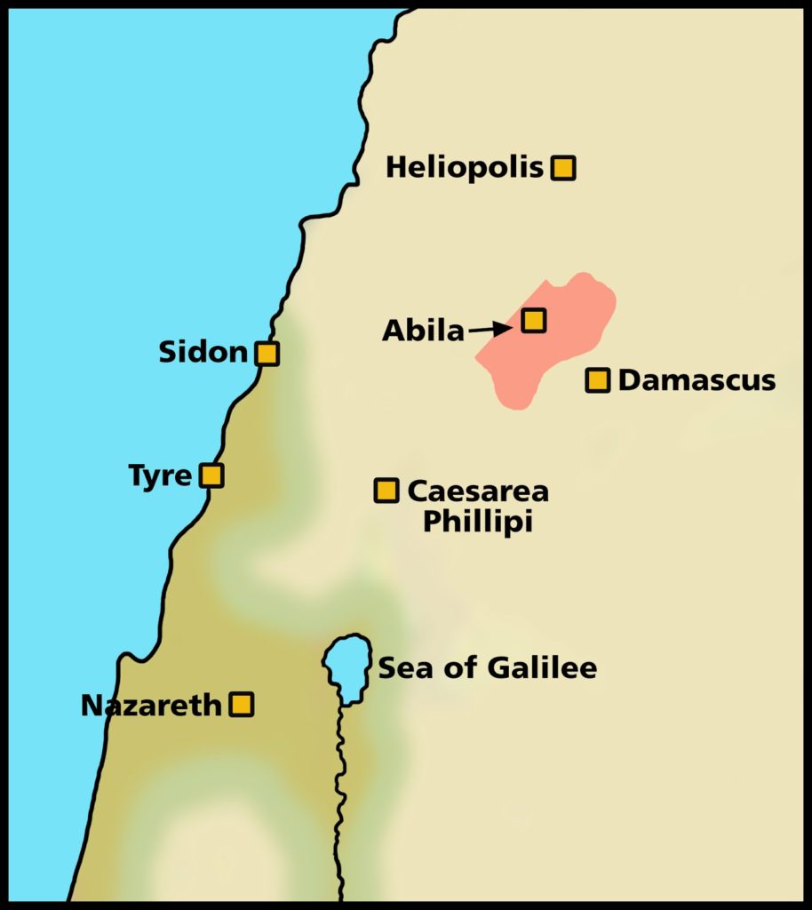
One person referred to in Luke 3:1-2 is “Lysanias, tetrarch of Abilene.” Lysanias is one of the more obscure persons mentioned by Luke with one extra-biblical reference being an inscription, dated to the reign of Tiberius, found in the area of Abilene that reads, “. . . a freedman of Lysanias the Tetrarch, having made the road, erected the Temple” (Journal of the Royal Geographical Society of London, V. 20, p. 43). The area known as Abilene was a small district on the eastern side of the Anti-Lebanon mountains that gets its name from Abila, its chief town. The town of Abila shown on the following map was located on the route between Damascus and ancient Heliopolis (modern Baalbek, Lebanon).

Fig. 1 – Abila of Abilene

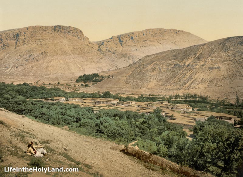
Today the village of Suk Wadi Barada marks the spot of ancient Abila. It is situated in Syria, about 10 miles northwest of Damascus. The following photochrom image was taken in the 1890s of the village.

Fig. 2 – Suk Wadi Barada

For a brief discussion concerning the dating of the Lysanias inscription noted above, see chapter 7 in F. F. Bruce, The New Testament Documents.

As time permits, a future post may deal with the possibility that there was more than one ruler with the name “Lysanias” connected to the area of Abilene (Abila).

By way of note, the Abila of Abilene that is tied to the account in Luke is distinct from another city by the same name located in the Decapolis to the east of the southern end of the Sea of Galilee.

Further,  John Brown University is now in the process of excavating Abila of the Decapolis as described at this link.

For similar correlations between the biblical text and ancient sources, see Bible and Archaeology – Online Museum.

Share:

The big story of the week is the discoveries made in excavations at Caesarea, including the altar of Herod’s temple, an inscribed menorah, and a statue of Asclepius. You can read the press release here or download high-res photos here. Haaretz has the best illustrated story. The Times of Israel emphasizes the discovery of an inscribed menorah. The Jerusalem Post focuses on the $27 million project. Art Daily provides another brief summary.This 3-minute video includes English subtitles.

A colossus of Ramses II has been re-erected in front of Luxor Temple’s first pylon.

Ten nations have created an “Ancient Civilizations Forum” to work together to protect ancient heritage from Islamic extremism.

Israeli police arrested a man in Hawara and confiscated hundreds of antiquities they discovered in his house.

A petition is now circulating to save the Yale Babylonian Collection.

A first-century AD bust of Drusus Minor will be returned to Italy by the Cleveland Museum of Art.

Should Egypt sell some of its artifacts to raise money?
BBC: “Madain Saleh isn’t as well-known as Petra, but the Nabateans’ second-largest city played a
crucial role in their mysterious empire.”

Simon Gathercole looks at the historical evidence for Jesus’s life and death.
BAS has published online a web-exclusive chart of 53 biblical people who have been confirmed in inscriptions.

Wayne Stiles’s recent post on Mount Carmel includes photos of its beauty and its burning.

Leon Mauldin visited Bethphage yesterday.

What happened to the cross that Jesus died on?

Mark Hoffman suggests that you may want to download Google Earth before it’s gone.


The Corinth Excavations Archaeological Manual has been published and a pdf has been made available for free. The post includes a link to previously published archaeology manuals.

The four-volume Dictionary of Daily Life in Biblical and Post-Biblical Antiquity is available on
Logos at a pre-pub price of $51. I recommend it.

I’ll be traveling much of May and June, so I probably will not be able to do many roundups.

HT: Joseph Lauer, Agade, Ted Weis, Charles Savelle

Share:

Post by Seth M. Rodriquez, Ph.D.

“What do those words make you see?” Years ago, I worked as a reading tutor. It was my job to help people decode written words and understand the meaning being communicated through those words.

Reading comprehension experts will tell you that the best way to understand and remember what you read is to allow the words to create pictures in your head. As a tutor, I was trained to repeatedly ask the question: “What do those words make you see?”

It is no different when we read the Bible. As we read, we should allow the words on the page to form pictures in our head. Unfortunately, this can sometimes prove to be a challenge. Often we are not familiar with the places and things mentioned in the Bible. How tall was Mount Carmel where Elijah called down fire from heaven? How dry is the Judean Wilderness where David hid from Saul and where Jesus was tempted? What is a horned altar and what did look like?

Fortunately, today we have the means to bridge the gap between our world and the world of the Bible.
Collections of images provided through websites such as BiblePlaces.com and LifeintheHolyLand.com can go a long way in helping us to form vivid pictures in our minds of biblical places, characters, and events. To help you on the journey, I am kicking off a new series on this blog called, “On Location.” As the name implies, we’ll go “on location” with the people in the Bible. We will see some of the same sights they did … or at least see what these sights look like in modern times. The goal is to help you more accurately visualize the biblical stories.

To get things started, let’s talk about Abraham. Abraham’s journey started at the east end of the Fertile Crescent in the city of Ur in Mesopotamia. From there, he moved to Haran in the northern part of the Fertile Crescent, and eventually moved to the land of Canaan to the southwest. The story begins in Genesis 12 …

“Now the Lord said to Abram, ‘Go from your country and your kindred and your father’s house to the land that I will show you. And I will make of you a great nation, and I will bless you and make your name great, so that you will be a blessing. I will bless those who bless you, and him who dishonors you I will curse, and in you all the families of the earth shall be blessed.’ So Abram went, as the Lord had told him, and Lot went with him. Abram was seventy-five years old when he departed from Haran. And Abram took Sarai his wife, and Lot his brother’s son, and all their possessions that they had gathered, and the people that they had acquired in Haran, and they set out to go to the land of Canaan. When they came to the land of Canaan, Abram passed through the land to the place at Shechem, to the oak of Moreh. At that time the Canaanites were in the land. Then the Lord appeared to Abram and said, ‘To your offspring I will give this land.’ So he built there an altar to the Lord, who had appeared to him. (Genesis 12:1–7, ESV)


What do those words make you see? Let me help you out with the last few verses where Abraham enters Canaan for the first time and arrives at the site of Shechem. 
Shechem (modern Nablus) lies between Mount Gerizim and Mount Ebal in the very center of the land of Canaan. However, there is no indication archaeologically or in the biblical text that there was actually a city there in Abraham’s day. The city seems to have been founded in about 1900 B.C., about 200 years after Abraham would have passed through here. So to help paint our mental picture, we need to get out of the modern city located at the site of Shechem and see some wide open spaces nearby. In the image below, we are standing a few miles away from Shechem and we can see Mount Gerizim and Mount Ebal in the distance. This is similar to what Abraham would have seen back in 2100 B.C.
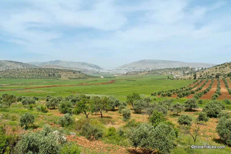
Mount Gerizim, Shechem, and Mount Ebal from the East

A close-up image of the Shechem area will help us complete our mental picture. The modern city sprawls over the area today. So to help us form a proper image in our minds, it is helpful to dig into one of the historic collections provided through LifeintheHolyLand.com and go back in time. This next image shows what the area between Mount Gerizim and Mount Ebal looked like about 100 years ago. The photographer is standing on Mount Gerizim and looking across the valley. In Abraham’s day, this area probably had many more trees than can be seen in the image below (Joshua 14 mentions a forest covering this region) but you can get a feel for what the topography is like through this photograph.
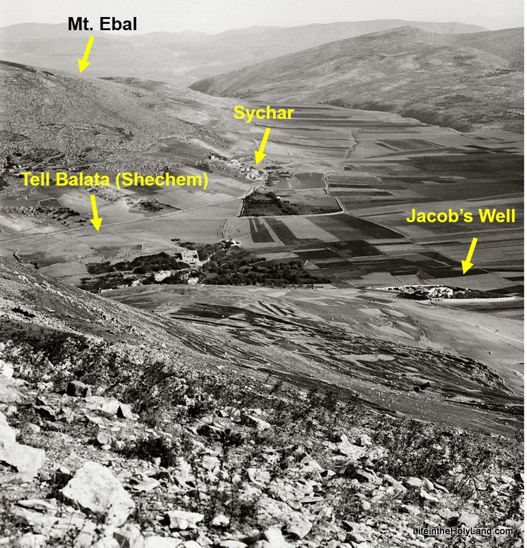
Looking north from Mount Gerizim (photo taken 1910-1920)

According to Genesis 12, this was the place where God spoke to Abraham shortly after he entered the land of Canaan for the first time. This is where He made Abraham the promise, “To your offspring I will give this land.” And in response, this is where Abraham built an altar to the Lord.

More images and information about Shechem can be found on the BiblePlaces website here.

Historical images of places from Abraham’s life can be found on the LifeintheHolyLand website here.
The images used in this post were taken from Vol. 2 of the Pictorial Library of Bible Lands (available for purchase here) and Vol. 1 of the American Colony and Eric Matson Collection (available for purchase here).
Share:

“An Egyptian archaeological mission in Luxor has announced the discovery of a major tomb in the city’s west bank area dating back to the 18th Dynasty and containing priceless artefacts.”

Israeli archaeologists have begun to study an ancient Jewish pyramid near Khirbet Midras in the Shephelah.

Archaeologists have discovered an estate of Emperor Marcus Aurelius in the mountains of southwestern Turkey.

Symbols found on the the Vulture Stone at Gobekli Tepe in Turkey has led researchers to propose the earth was struck by a devastating comet around 11,000 BC.

Shots were fired near St. Catherine’s Monastery at Mount Sinai, but there are different explanations of what happened.

The Qumran and Bible Exhibition is now online with an audioguide and with a video introduction.

The latest edition of The Holy Land Magazine is online and includes tourist articles on Nazareth Village, Yad VaShem, Neot Kedumim, and more.

Tom Powers considers David Bivin’s recent post on the deteriorating road to Emmaus and adds some observations of his own.

Elizabeth Sloane, writing in Haaretz, asks, “Did the Egyptian goddess Hathor originate with Semitic miners from Canaan?”

The Temple Mount Sifting Project must meet its fundraising goal or it will receive none of the pledged funds.

The Amarna Letters are the topic of the week on The Book and the Spade with guest Alice Mandell.

The Khirbet el-Maqatir exhibit in Pikeville, Kentucky is drawing visitors.

Eisenbrauns is offering the Victor Avigdor Hurowitz memorial volume at a savings of 40% for a few more days: Marbeh Ḥokmah: Studies in the Bible and the Ancient Near East (2 vols). List $139.50; sale: $83.70.

HT: Charles Savelle, Ted Weis, Joseph Lauer, Agade

Share: