The Israel Antiquities Authority captured a group of thieves attempting to sell eleven ossuaries looted from a tomb in Jerusalem. The IAA issued a press release about the arrest and plunder today.
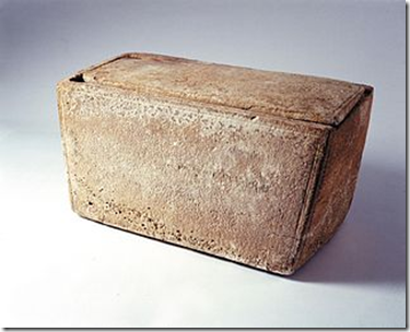
A number of suspects were apprehended in the early hours of Friday (28.3) in a joint operation by inspectors of the IAA Unit for the Prevention of Antiquities Robbery and detectives and patrolmen of the Shefet police station in Jerusalem. They were caught while in possession of eleven decorated stone ossuaries – ancient coffins – that the Jewish population used for burial in the Second Temple period, two thousand years ago. Some of the ossuaries still contained the skeletal remains of the deceased.
[…]
Shallow engravings, etched in the past by means of a sharp stylus, were found on the walls of two of the seized ossuaries. They cite the names of the deceased whose bones were collected in the coffins. One of the engraved ossuaries that were found bore the name “Ralfin”, written in squared Hebrew script characteristic of the Second Temple period. This name is apparently a Hebraized form of an unusual Roman name. According to Dr. Eitan Klein, deputy director of the Unit for the Prevention of Antiquities Robbery, who examined the ossuaries, “this is the first time this name appears on an ossuary from the Land of Israel”. On the other ossuary is a Greek inscription that could not be deciphered, and below it the name “Yo‘azar”, in squared Hebrew script. The name Yo‘azar is a common Jewish name in the Second Temple period, and occurs in contemporary written sources, such as Josephus’ writings. The name appears in this form and a slightly different form – “Yeho‘azar” – on numerous Jewish ossuaries from this period.
Some of the ossuaries were engraved with inscriptions in squared Hebrew script, characteristic of the Second Temple period and some bore Greek inscriptions, including the names of the deceased.
According to Dr. Eitan Klein, “these are singular finds. The inscriptions on the ossuaries provide us with additional characters and names from amongst the Jewish population in the Second Temple period, and the motifs adorning the ossuaries will supplement our knowledge with new information about the world of Jewish art in this period”. Dr. Klein stated, “There is no doubt that the ossuaries were recently looted from a magnificent burial cave in Jerusalem. Remnants of paint remained on top of the ossuaries and the containers themselves belong to the group of “magnificent Jerusalem” ossuaries that were manufactured in the city in antiquity”.