fbpx

If you’re in the Dallas area this Friday, you might want to stop in for a free lecture on Tel Burna (possibly biblical Libnah) at Dallas Theological Seminary. The announcement gives location details but is not clear who is giving the lecture. I think it is Chris McKinny, one-time writer of our popular “Secret Places” series. (We’re hoping we see Chris back around these parts before too long!)

Ceramic mask fragment discovered at Tel Burna
Share:
(Post by A.D. Riddle)

The University of Chicago’s Martin Marty Center for the Advanced Study of Religion is sponsoring a three-part lecture series on “Assyria in Israel, Judea, and the Levant.”

The first lecture presented by Irene Winter (Harvard University, emerita) is on February 11 (Tuesday). No title is yet provided for this lecture.

The second lecture by David Wright (Brandeis University) on “The Covenant Code Appendix (Exodus 23:20–33) and Assyrian Royal Inscriptions” will be given on February 26 (Wednesday).

The last lecture by Elizabeth Bloch-Smith (Saint Joseph’s University) will address “The Assyrian Military Impact on the Ground and in Biblical Texts” on March 13 (Thursday).

The series will take place in the Divinity School’s Swift Hall Common Room on the 1st floor. Lectures begin at 5:00pm and end at 6:30pm. The website for the lectures is here.

Relief from Sennacherib’s palace in Nineveh depicting
the Assyrian siege of Lachish in the reign of Hezekiah.
Share:

There is a great opportunity for older archaeology enthusiasts to have their photographs preserved in the Non-Professional Archaeological Photographs-project. The team is particularly interested in photographs taken by students and volunteers in excavations prior to 1980. If you have some of these photos, or if you know someone who does, please get in touch with NPAPH Project as soon as you can.

The official website has lots of details. You can also check out their Facebook page. The trailer below describes their vision.

Some archives are already online for viewing:

Dan P. Cole Photo Collection – Shechem and Gezer

Gordion Expedition Collection – the ancient Phrygian capital

Leo Boer Photograph Collection, 1953-1954 – travels of a student

Others cover Italy, The Netherlands, and Guatemala.

Share:

Leen Ritmeyer has photos and interpretation of the latest illegal excavations on the Temple Mount.

Ritmeyer suspects the revealed wall line may be the northern boundary of the 500-meter square pre-Herodian Temple Mount.

New excavations began at Tel Hebron this week.

Gershon Galil has translated the earliest Jerusalem alphabetic inscription be a reference to “wine part.”

Some rare fabrics dyed with extract from the murex shell have been discovered. The three colors found “represent the most prestigious colors in antiquity: indigo, purple and crimson.”

A couple of Top Discoveries of 2013 have been posted: Gordon Govier (Christianity Today) and
Noah Wiener (Biblical Archaeology Society).

In 2012, from time to time I surveyed excavation reports published by the Israel Antiquities Authority. I did not have time for that in 2013, but you can peruse the list here.

Scholars are using Google Earth to trace ancient trade routes around Antioch of Syria.

Currently on exhibition at the Israel Museum: Mapping the Holy Land II: Cartographic Treasures from the Trevor and Susan Chinn Collection.

Logos Bible Software has a pre-publication sale on Biblical Archaeologist/Near Eastern Archaeology 1992–2011 ($140).

Timothy Valentino has written an outstanding eulogy for Professor David A. Dorsey.

HT: Joseph Lauer, Jack Sasson, Charles Savelle

Share:

Some intrigue surrounded the recent discovery of a well-preserved Israelite proto-Aeolic capital when the tour guide who stumbled across it reported that the authorities told him to keep silent about it, ostensibly for political reasons. For the background and photos, see this report from last April.

This week a story in Arutz-7 claims that the secret location will be revealed next Friday. The article begins:

The location of a major archaeological find that was kept secret until now will be revealed to the public on Friday, next week. The find is being touted as a royal castle that could have belonged to Israel’s most celebrated king – the Bible’s King David.

There are several problems with this sensational report: (1) this type of architecture in Judah dates to several centuries after the time of David; (2) the impressive proto-Aeolic capital is in a water system and evidence of a palace is so far lacking; (3) the location has already been published in D. Ein-Mor and Z. Ron, “An Iron Age Royal Tunnel Spring in the Region of Nahal Rephaim,” in G. Stiebel et al., eds., New Studies in the Archaeology of Jerusalem and its Region, 2013. An abbreviated version is available online in Hadashot Arkheologiyot. (This reference comes from Zachi Dvira, via Joseph Lauer.)

It is possible that by overreaching in claims, the media may obscure the true significance of this discovery. Rather than speak of palaces and David, the comparison should rather be made with Hezekiah’s Tunnel.

(1) Both of these tunnels are water systems that bring water from a spring to a storage pool. (2) These are two of the longest underground water channels in the Judean hills, with Hezekiah’s Tunnel running 1,750 feet and the new one at ‘Ain Joweizeh running about 700 feet. (3) Both date to about the 8th century BC, with the date of the ‘Ain Joweizeh tunnel coming from a comparative analysis of other proto-Aeolic capitals found in Judah and Jordan. (4) Both seem to have royal connections, with the Siloam Inscription in Jerusalem and the royal architecture at ‘Ain Joweizeh.

What was the purpose of the ‘Ain Joweizeh tunnel? The excavators suggest that it may have been connected to “an estate or royal palace similar to Ramat Rahel here during the eighth–seventh centuries BCE; another possibility is a settlement from this period that is mostly buried beneath the farming terraces covering the ravine.” Presumably significant features are not visible on the surface and the excavators did not have the time to begin a large-scale excavation of the area. The proximity of the site to the security wall may complicate present or future attempts at excavation.

The site is located 5.5 miles (9 km) southwest of the Old City of Jerusalem, 3.5 miles (5.5 km) northwest of Bethlehem, and just down the slope to the west of Har Gilo. The map below shows the site circled in red.

Sheet_17-joweizeh
Western environs of Jerusalem
Map from the Survey of Western Palestine (1881)
google-earth-ain-joweizeh
Western environs of Jerusalem
Screenshot from Google Earth
http://www.hadashot-esi.org.il/Images//6087-1.jpg
Location map and plan of the spring based on Marcus and Ben-Yosef and Ron. Image from Hadashot Arkheologiyot
http://www.hadashot-esi.org.il/Images//6087-4.jpg
Proto-Aeolic capital in location
Image from Hadashot Arkheologiyot
http://www.hadashot-esi.org.il/Images//6087-3.jpg
Reconstruction of proto-Aeolic capital
Image from Hadashot Arkheologiyot

Another image showing the inside of the tunnel itself is posted at Maariv. (HT: Joseph Lauer)

Share:

(Post by Seth M. Rodriquez)


After a holiday break, we are back with the next installment of our series on “obscure sites in the PLBL.” Today we will be focusing on the Neolithic site of Catalhoyuk in central Turkey. Like many archaeological sites, at first glance this location looks like a normal hill.  But there is much more than meets the eye…

The PLBL provides the following general information about the site in the PowerPoint annotations:

Çatalhöyük (Catal Hoyuk, Catal Huyuk) is located in the Konya Plain, about 21 miles (37 km) southeast of Konya
(ancient
Iconium). It is the largest Neolithic site that has been discovered and is very
well-preserved. The site consists of two flat mounds, a large mound to the east
and a smaller mound to the west. The mounds are said to resemble the shape of a
fork, hence the name of the site (
çatal is Turkish for fork). The eastern
mound of
Catalhoyuk rises 65 feet (21 m) above the surrounding plain and covers an area of 32
acres (13 ha). 
Thirteen occupational strata have been excavated dating to the Neolithic
period, the earliest of which dated to ca. 7200 BC and the latest to ca. 5500
BC. The town had a population of up to 8,000 people.


And the surface of the tell is nothing to write home about, as you can see in the photograph below.

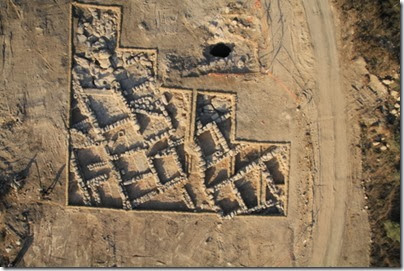
However, there are some striking features about this site. As the archaeologists dug into the tell, they discovered a city that was comprised of houses connected to houses with no streets. It appears that the inhabitants of the city walked over the flat roofs of the houses to get from one end of town to the other! Below is a photograph of some of the excavations being conducted at the site. (You get two-for-one this week.)

Again we turn to the annotations in the PLBL for more information:

Catalhoyuk is made up of domestic dwellings
packed together without any streets. The people moved about on the roofs of the
houses and entered the houses through holes using ladders. The houses were made
of mudbrick and the interiors were plastered and decorated with murals. Houses
typically consisted of two rooms with raised platforms along the walls…. An oven was often
located near the ladder, beneath the hole in the roof. Throughout the town,
there are a number of large courts.

So the next time you are tempted to complain about your neighbor’s kids playing too loud in the backyard or the high volume of traffic that passes in front of your house, just be grateful that you don’t live in the ancient city of Catalhoyuk where your neighbors would have walked on your roof on their way to work.

These photographs and annotations are available in Volume 9 of the Pictorial Library of Bible Lands and is available here for $34 (with free shipping). Other photographs from this volume can be seen here, here, and here.

A helpful video that shows a reconstructed time lapse of how the city was built and the ruins were formed can be found here.

Share: