Noah Wiener has a follow-up article on the spring tunnel discovered in the Rephaim Valley. He includes a great photo of the tunnel.

Zachi Zweig disagrees with Leen Ritmeyer’s dating of the newly revealed course of ashlar stones on the Temple Mount. He dates it to the Early Islamic period.

A woman has turned over to the IAA a large collection of pottery discovered by a relative in the Mediterranean Sea.

The winter dig at Khirbet el-Maqatir began in the snow. They spent several weeks excavating three caves.

The ancient Myceneans once used portable grills at their picnics.

Archaeologists have discovered grain from the Neolithic period at Çatalhöyük.

The report for the 2013 excavation season at Tall el-Hammam is now online.

The first two volumes of NGSBA Archaeology are available for download. (NGSBA = Nelson Glueck School of Biblical Archaeology.)

Just published: The Oxford Handbook of the Archaeology of the Levant: c. 8000-332 BCE, edited by
Margreet L. Steiner and Ann E. Killebrew. Oxford University Press. 912 pages. $165.

Wayne Stiles explains how to make the maps in your Bible atlas fully searchable.

HT: Joseph Lauer, Tim Graham, Jack Sasson

Share:

(Post by Seth M. Rodriquez)


Our “obscure site” this week is mentioned only once in the Bible and almost in passing. However, it was the starting point of one of the most famous adventures of the apostle Paul.

In the first century, the city of Myra stood near the southern shores of western Asia Minor. It lies over two miles from the shore so it was closely associated with its port city of Andriace. In fact the harbor city was sometimes just referred to as Myra. The city and its harbor were most likely founded in the fifth century B.C. In the Roman period it was a key location along the trade route used by sailing vessels as they transported grain to Rome. The harbor of Myra was a staging ground where grain from Egypt would be transferred to boats that would carry it on to Rome. In fact, the boat that Paul boarded in Myra may very well have been one of these granary boats (see Acts 27:5-6, 38).

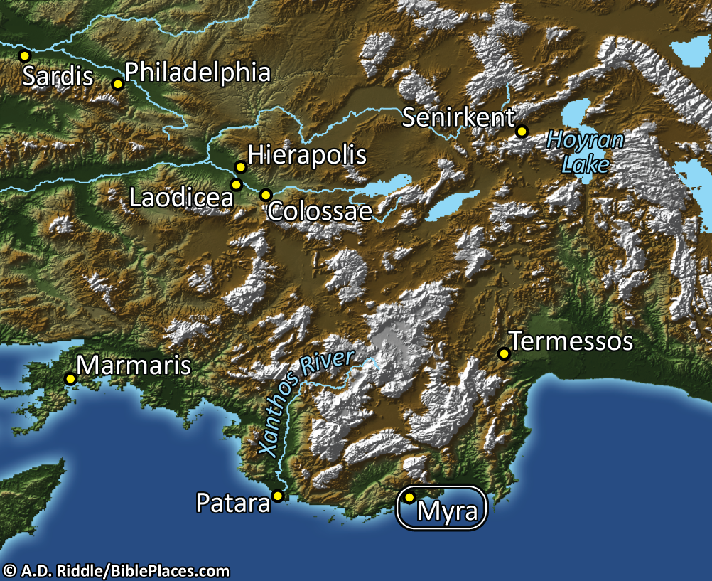
Paul visited Myra while he was a prisoner of the Romans, on his way to a trial before Caesar in Rome. The Wycliffe Historical Geography of Bible Lands, by Charles F. Pfeiffer and Howard F. Vos, provides the following description of what it would have been like to travel by boat from Caesarea to Myra like Paul did:

The westerly winds which favored the voyage from Patara or Myra to Tyre made the return voyage from Tyre to Myra an impossibility. The regular course for ships from Palestine or Phoenicia was northward past the east end of Cyprus and thence along the Asia Minor coast. Then, by means of ocean currents and land winds which blew off the coast, they made their way westward toward Myra. The voyage from Caesarea to Myra might be done in as short a time as ten days, but recorded trips over that route took as long as twenty days. Ships of the Roman grain fleet (on one of which Paul probably sailed) might take the same route if the winds required, but normally they sailed directly from Alexandria to Myra on the Lycian coast …

In the photograph below, you can see the area where the ancient harbor once existed (it has since filled up with silt):

Pfeiffer and Vos provide the following details about Myra and its significance:

In Greek times Patara surpassed Myra, but in Roman times Myra, forty miles eat of Patara, became the chief seaport of Lycia. It grew especially as a result of the Alexandrian grain trade with Italy. Though Myra was located two and one-half miles up the Andracus River from the coast, the same name was often applied to its harbor, Andriaca.

There are several “obscure sites” that Paul passed on his journey to Rome. In future posts we will explore some of them.

This photo and map are available in Volume 10 of the Pictorial Library of Bible Lands and is available here for $34 (with free shipping). This volume also includes the less obscure sites of Ephesus, Smyrna, and Pergamum. For other posts in our series on “obscure sites in the PLBL,” see here.

The excerpts are taken from Charles F. Pfeiffer and Howard F. Vos, Wycliffe Historical Geography of Bible Lands (Chicago: Moody Press, 1967), p. 376.

Share:

If you’re in the Dallas area this Friday, you might want to stop in for a free lecture on Tel Burna (possibly biblical Libnah) at Dallas Theological Seminary. The announcement gives location details but is not clear who is giving the lecture. I think it is Chris McKinny, one-time writer of our popular “Secret Places” series. (We’re hoping we see Chris back around these parts before too long!)

Ceramic mask fragment discovered at Tel Burna
Share:
(Post by A.D. Riddle)

The University of Chicago’s Martin Marty Center for the Advanced Study of Religion is sponsoring a three-part lecture series on “Assyria in Israel, Judea, and the Levant.”

The first lecture presented by Irene Winter (Harvard University, emerita) is on February 11 (Tuesday). No title is yet provided for this lecture.

The second lecture by David Wright (Brandeis University) on “The Covenant Code Appendix (Exodus 23:20–33) and Assyrian Royal Inscriptions” will be given on February 26 (Wednesday).

The last lecture by Elizabeth Bloch-Smith (Saint Joseph’s University) will address “The Assyrian Military Impact on the Ground and in Biblical Texts” on March 13 (Thursday).

The series will take place in the Divinity School’s Swift Hall Common Room on the 1st floor. Lectures begin at 5:00pm and end at 6:30pm. The website for the lectures is here.

Relief from Sennacherib’s palace in Nineveh depicting
the Assyrian siege of Lachish in the reign of Hezekiah.
Share:

There is a great opportunity for older archaeology enthusiasts to have their photographs preserved in the Non-Professional Archaeological Photographs-project. The team is particularly interested in photographs taken by students and volunteers in excavations prior to 1980. If you have some of these photos, or if you know someone who does, please get in touch with NPAPH Project as soon as you can.

The official website has lots of details. You can also check out their Facebook page. The trailer below describes their vision.

Some archives are already online for viewing:

Dan P. Cole Photo Collection – Shechem and Gezer

Gordion Expedition Collection – the ancient Phrygian capital

Leo Boer Photograph Collection, 1953-1954 – travels of a student

Others cover Italy, The Netherlands, and Guatemala.

Share:

Leen Ritmeyer has photos and interpretation of the latest illegal excavations on the Temple Mount.

Ritmeyer suspects the revealed wall line may be the northern boundary of the 500-meter square pre-Herodian Temple Mount.

New excavations began at Tel Hebron this week.

Gershon Galil has translated the earliest Jerusalem alphabetic inscription be a reference to “wine part.”

Some rare fabrics dyed with extract from the murex shell have been discovered. The three colors found “represent the most prestigious colors in antiquity: indigo, purple and crimson.”

A couple of Top Discoveries of 2013 have been posted: Gordon Govier (Christianity Today) and
Noah Wiener (Biblical Archaeology Society).

In 2012, from time to time I surveyed excavation reports published by the Israel Antiquities Authority. I did not have time for that in 2013, but you can peruse the list here.

Scholars are using Google Earth to trace ancient trade routes around Antioch of Syria.

Currently on exhibition at the Israel Museum: Mapping the Holy Land II: Cartographic Treasures from the Trevor and Susan Chinn Collection.

Logos Bible Software has a pre-publication sale on Biblical Archaeologist/Near Eastern Archaeology 1992–2011 ($140).

Timothy Valentino has written an outstanding eulogy for Professor David A. Dorsey.

HT: Joseph Lauer, Jack Sasson, Charles Savelle

Share: