(Post by Seth M. Rodriquez)

Our picture of the week focuses on the obscure site of Serabit el-Khadim in the Sinai Peninsula.  This is not a place that you will visit on your typical tour of Egypt.  In fact, it was not a place that even many ancient Egyptians would have visited!

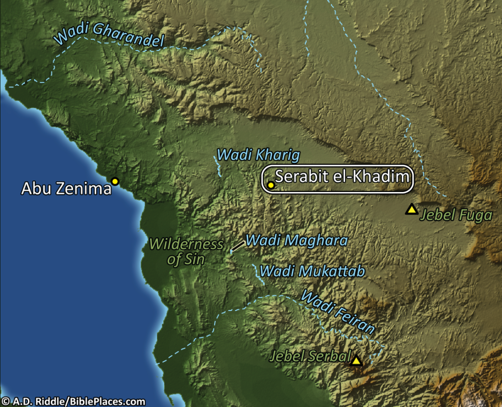
Located about 17 miles (27 km.) from the Gulf of Suez, Serabit el-Khadim was a mining site. Teams of miners would be sent to this region by the Pharaoh to dig up turquoise and copper. However, this was only carried out during times when there was a strong central government in Egypt.  The site was occupied on and off from the time of the 4th Dynasty (c. 2600 B.C.) to the time of the 20th Dynasty (c. 1100 B.C.) The following map, which is included in Volume 7 of the Pictorial Library of Bible Lands, shows its position near the Gulf of Suez. (A special thanks is due to A.D. Riddle who created the original maps in the PLBL and has volunteered to customize those maps for this series of blog posts.)

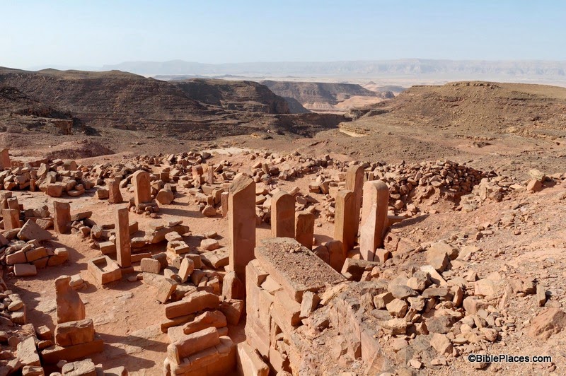
Pictured below are the ruins of the Temple of Hathor that stood at this site and the scorching desert of the Sinai spreading out below it. Starting with a small shrine within a cave, this temple complex grew larger and larger over the course of several hundred years as successive Pharaohs each added their own special touch.

In The Archaeological Encyclopedia of the Holy Land, the temple and its development is described in the following way:

During the excavations an early high place, and a series of temples that replaced it, were revealed within a temenos (enclosure), 200 feet by 140 feet in area. The original Egyptian shrine consisted of a cave sacred to Hathor, goddess of the land and of minerals. In front of the cave a portico was constructed, and then a large court; and further shrines were added during the long Egyptian occupation of the site. Within the temenos were caves dedicated to other deities, such as the moon-god Thoth.

Mining of turquoise did not begin at Serabit el-Khadem until the time of the 12th Dynasty …. Turquoise was essential to the Egyptian jewelry industry, while copper was important for the production of tools and weapons …. The earliest Egyptian monarch to send an expedition to Sinai was Sneferu, the first king of the 4th Dynasty. Mining continued with some interruption down to the end of the 6th Dynasty, when both mines were again worked under Ammenemes III of the 12th Dynasty. Stalae set up in the temple record the various mining expeditions, of which no less than seven took place during Ammenemes III’s reign. …

The temple of Serabit el-Khadem had been enlarged repeatedly. Continuing the process, Sethos I, founder of the 19th Dynasty, extended it. Rameses II and Merneptah are also recorded in the temple, as is Rameses III of the 20th Dynasty. At the beginning of the 21st Dynasty the mines of Sinai went out of use once more.

This map and photograph, along with over 1,000 other images, are available in Volume 7 of the Pictorial Library of Bible Lands, available here for $34 (with free shipping).

Excerpt is taken from “Serabit el-Khadem,” in The Archaeological Encyclopedia of the Holy Land, Logos Edition, ed. Avraham Negev (New York: Prentice Hall Press, 1990).

Share:

The holiday of Hanukkah is an appropriate time to announce the discovery of a Hasmonean-period building in Jerusalem. The structure is located in the Central Valley just south of the Dung Gate in the former Givati parking lot. The Israel Antiquities Authority describes the find in a press release.

In recent months remains of an impressive building from the Hasmonean period (second century BCE) are being unearthed in excavations the Israel Antiquities Authority is directing in the Giv‘ati parking lot, located in the City of David in the Walls Around Jerusalem National Park. The excavations are sponsored by the “Friends of City of David”.
The building stands c. 4 meters high and covers an area of c. 64 sq. m. The building’s broad walls (more than one meter thick) are made of roughly hewn limestone blocks that were arranged as headers and stretchers, a construction method characteristic of the Hasmonean period.
Although numerous pottery vessels were discovered inside the building, it was mainly the coins that surprised the researchers. These indicated the structure was erected in the early second century BCE and continued into the Hasmonean period, during which time significant changes were made inside it.
According to Dr. Doron Ben Ami and Yana Tchekhanovets, the excavation directors on behalf to the Israel Antiquities Authority, “The importance of this discovery is primarily because of the conspicuous paucity of buildings from the Hasmonean city of Jerusalem in archaeological research, despite the many excavations that have been conducted to date. Apart from several remains of the city’s fortifications that were discovered in different parts of Jerusalem, as well as pottery and other small finds, none of the Hasmonean city’s buildings have been uncovered so far, and this discovery bridges a certain gap in Jerusalem’s settlement sequence. The Hasmonean city, which is well-known to us from the historical descriptions that appear in the works of Josephus, has suddenly acquired tangible expression”.

The story is also reported by Arutz-7 and Israel HaYom.

We’ve reported on excavations at this same area many times in the past:

Hasmonean period building uncovered in Jerusalem
Hasmonean building in Jerusalem.
Photo by Assaf Peretz, courtesy Israel Antiquities Authority.
Aerial view of City of David, tb010703 givati parking diagram 
Jerusalem from the southwest Click photograph for higher-resolution version.

UPDATE (12/4): Eric Welch has sent this photo taken at the excavations during the summer.

Givati
Excavations in Givati parking lot. The three chambers in the foreground correspond with the chambers on the right side of the top photo.
Share:

We announced this in the latest BiblePlaces Newsletter, but if you missed that, you may want to know that a new edition of the Satellite Bible Atlas is available. The hardcover edition is more durable and lays flat, making it ideal for study at home and on the field. For only $28, this is an affordable investment for all who love the Bible. Here are a few reasons why:

1. Every map covers a full page and is in full color. That allows for lots of detail and context.

3. The atlas provides maps of everything from Abraham’s journey from Ur to Paul’s arrival in Rome. Whatever you’re reading or teaching, you will find a map that marks the location and explains the event. You’ll never have to guess where something took place.

7. Purchase includes free access to all of the maps in digital (jpg) format. This makes it easy to use the maps in the classroom and on location.

You can see the full list of why I think this new atlas by Bill Schlegel is a fantastic resource here.

A wall/door map is also available for $7, but if you buy it together with the atlas, the cost is only $4.

If you’re like us, you always wonder what surprise you’ll find when you go to checkout and learn the shipping cost. For those in the U.S., shipping is free. (And for those not in the U.S., the shipping is outrageous, but that’s beyond our control. There is an Israeli distributor who can ship to some countries less expensively.)

We encourage you to consider this as a gift for a parent, child, pastor, teacher, or friend. This is a unique resource at a terrific price.

Share:

Aren Maier reports that he may have been the last archaeologist to see the excavations of Eshtaol.

But you can see a video of the site before it was buried.

Some are unhappy that the Palestinian Authority is excavating a Hasmonean fortress between Bethlehem and the Herodium.

Barry Britnell saw the Jerusalem movie and he declares it to be “fantastic.” You can see if it is in a theater near you here.

The Kathleen Kenyon collection is now on display at the Ian Potter Museum in Melbourne.

This travel piece may inspire you to do more on your next trip to Israel than ride on a bus.

If you expect to be touring Israel in late May, you should plan now to avoid the pope.

You can save an extra 30% on any print book at Amazon through Dec 1, 11:59pm. Enter “BOOKDEAL” at checkout under the “Gift cards & promotional codes.” Up to $10 off. I recommend this book (for an amazing $21.47 after discount. I’ll say more about this book later, but not before this deal expires. Preview here.)

HT: Charles Savelle, Joseph Lauer

Share:

I would like to see this:

Khirbet el-Maqatir: History of a Biblical Site will be a year-long exhibit of 42 artifacts from excavations in Israel at Khirbet el-Maqatir, thought to be the site of ancient Ai from Joshua 7-8. The Civil Administration for Judea and Samaria has approved the loan of these artifacts for exhibit at the Houston Baptist University’s Dunham Bible Museum from January 21-December 19, 2014. In conjunction with the exhibit, a symposium will be held on February 8th, focusing on the role of archaeology in understanding ancient history and biblical studies as well, including critical reflection on the excavations at Khirbet el-Maqatir and what light they shed on the ancient, biblical world. Starting from Genesis 12-13 and moving toward Maqatir’s magnificent monastery, 4,000 years of history will be on display. Special attention will be given to the Late Bronze Age fortress (Ai of Joshua 7-8) and the Early Roman/New Testament village (perhaps Ephraim of John 11:54).

I don’t believe that these artifacts have been on public display before. Khirbet el-Maqatir has been excavated under the direction of Bryant Wood since 1995.

The website also announces a conference to be held in conjunction with the exhibit. Speakers include Bryant Wood, Eugene Merrill, and Leen Ritmeyer. All of the details are here.

Khirbet el-Maqatir and Wadi Sheban aerial, tbs104369905
Khirbet el-Maqatir (left) and valley of Joshua’s ambush
Photo from Samaria and the Center
Share:

A report from the IAA describes a range of finds at a salvage dig being conducted on Highway 38 (aka “the Diagonal Route”) north of Beth Shemesh. The finds include a house from the Neolithic period with nine flint and limestone axes, some used for cultic purposes. Archaeologists also identified a Chalcolithic temple at the site.

In the archaeological excavation conducted at Eshta’ol an important and rare find from the end of the Chalcolithic period (second half of the fifth millennium BCE) was discovered in the adjacent area. During the course of the excavation six thousand year old buildings were exposed and a stone column (called a standing stone or mazzevā) was discovered alongside one of them. The standing stone is 1.30 meters high and weighs several hundred kilos. According to the excavation directors, “The standing stone was smoothed and worked on all six of its sides, and was erected with one of its sides facing east. This unique find alludes to the presence of a cultic temple at the site”. The archaeologists said, “In the past numerous manifestations have been found of the cultic practice that existed in the Chalcolithic period; however, from the research we know of only a few temples at ‘En Gedi and at Teleilat Ghassul in Transjordan.”

The site will be open to the public on Wednesday, November 27, from 2:00-4:00 p.m. The article does not state whether the site will be preserved, but given its location along the route of the highway expansion, it seems unlikely. The full story is here and high-resolution photos are available here. The story is also reported in Arutz-7 and The Times of Israel, both of which provide details for registering for the site visit.

Eshtaol is mentioned in the Bible in connection with the birth and burial of Samson (Judges 13:25; 16:31). Men from the tribe of Dan were sent from Eshtaol and Zorah to spy out the northern territory for settlement (Judges 18:2, 8, 11). The discoveries made are from earlier periods and are not at the ancient site of Eshtaol. For a brief discussion of the location of ancient Eshtaol, see our post here.

Work being conducted at the excavation
Eshtaol excavation
Photo by Yoli Shwarz, courtesy Israel Antiquities Authority
Share: