fbpx

(Post by Seth M. Rodriquez)

Joshua 3:15 makes the following comment in passing: “now the Jordan overflows all its banks throughout the time of harvest” (ESV). In the context of this chapter, Israel is about to cross into the Promised Land over a miraculously dry riverbed and this comment is included to give greater significance to the miracle. But before you rush to the Jordan with your camera during the next harvest season to snap a photo of this natural phenomena, let me save you some shekels by telling you that the flooding of the Jordan River is not something that happens today.

According to a 2010 report about the Jordan River (noted previously on this blog here), the Jordan River contains only 3% of the water that it did 100 years ago.  According to that report, the river discharged 1.3 billion cubic meters of water in the 19th and early 20th centuries (but see a more conservative estimate in the quotation below from the Encyclopaedia Judaica).  The report contrasts this with the current discharge of the river which is 20 to 30 million cubic meters.  Or to put it in numerical form:

  • 1,300,000,000 cubic meters per year in the past.
  •     30,000,000 cubic meters per year today.

 So “overflowing all its banks” is not a phrase that is typically used when describing the Jordan River today.

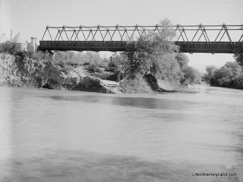
Fortunately, we have photographs from the first half of the 20th century that can help us illustrate this biblical phrase.  Our picture of the week (and a bonus picture) come from Volume 3 of The American Colony and Eric Matson Collection which focuses on Southern Palestine.  To show the contrast in the river’s levels, I have included two photos from that collection.  The first photo is a picture of the newly constructed Allenby Bridge with the Jordan River flowing peacefully about 30 feet below it. 

(As a side note, this is not the Allenby Bridge/King Hussein Bridge used today, but merely a forerunner of the modern bridge.)

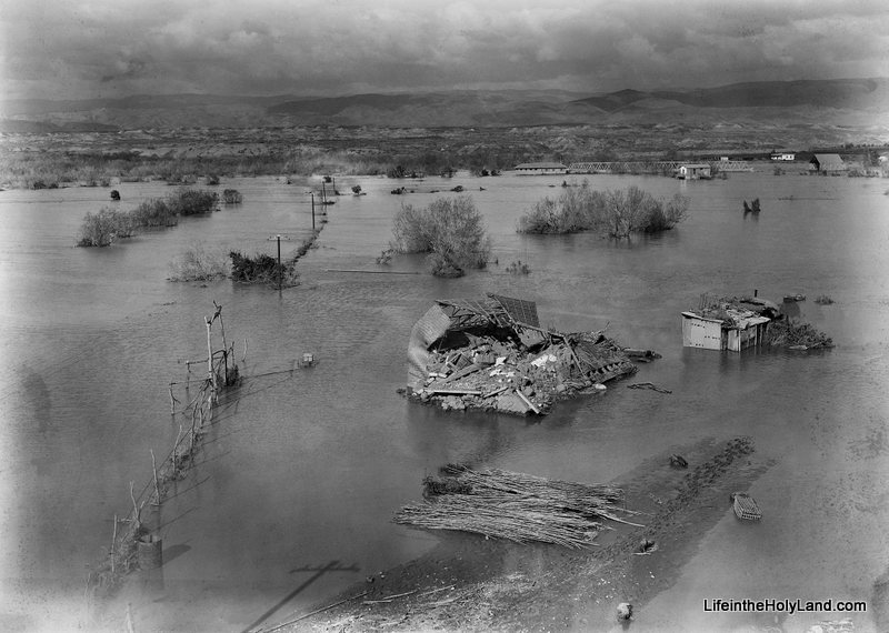
The date of the photograph above is around 1920.  The photograph below was taken in February, 1935.  This was an unusually high year for the Jordan River and it “overflowed all its banks,” damaging and destroying surrounding buildings and roads.

If you look closely in the upper right section of the photo you can see the Allenby Bridge with its bottom edge touching the water.  A closer view of the bridge can be seen in another photo from the collection which is posted here.

This flood year is mentioned in passing in the Encyclopaedia Judaica:

The Jordan discharges c. 875 million cu. m. into the Dead Sea a year; its yearly fluctuations are great and are caused mainly by the Yarmuk: in 1933, 287 million cu. m. and in 1935, 1,313 million cu. m.

According to this statistic, the Jordan River discharged 50% more water that year than the yearly average.  There is no way of knowing how much water was discharged during the year that Joshua and the Israelites crossed, but we can be certain that the photograph above is a much better illustration of how it looked than any picture that could be taken today.

Fortunately the future of the Jordan River is looking brighter.  This last summer, this blog noted a report about a plan by Israel to divert some additional water to Jordan River (see post here).  Perhaps future generations will again be able to see the Jordan overflow its banks.

These photographs and over 550 others are available in Volume 3 of The American Colony and Eric Matson Collection and can be purchased here for $20 (with free shipping).  Other historic images of the Jordan River can be seen here and here on LifeintheHolyLand.com, as well as a page devoted to illustrating Joshua and the Israelites “Entering the Promised Land” here

Share:

The Times of Israel takes its readers into the new Herod exhibit at the Israel Museum one week ahead of its opening. The article includes many photos, but may be slow loading.

Wayne Stiles has put together some great visual resources of Caesarea, including photos, video, map, and Google Street View.

City Lights over the Middle East – NASA has posted a short video taken from the International Space Station.

Air pollution has been a problem since the days of ancient Rome.

The Oriental Institute has launched its Integrated Database. Phase II will include images.

Metro publishes the “Top 10 archaeological finds of all time.”

Yosef Garfinkel will be lecturing on “Sanctuaries and Cult at Khirbet Qeiyafa” at the Southern
Adventist University’s Lynn H. Wood Archaeological Museum Lecture Series.

Keith Schoville is retiring from The Book & The Spade radio program.

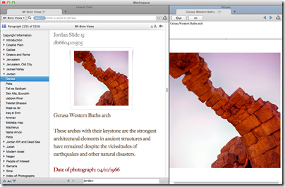
I am excited to announce that our photo collection Views That Have Vanished is now available as a
module for Accordance. The collection now has all the bells and whistles you would expect from Accordance.

HT: Daniel Wright, Aren Maeir, Charles Savelle, Jack Sasson

views-vanished-bivin-accordance
Screenshot from Views That Have Vanished
Share:

Bloomberg runs a story on the excavations at Tell Beth Shemesh, describing the recent discovery of a cultic site as well as the absence of pig bones.

We are standing in the middle of Israel on a quiet hill overlooking a fertile green valley.
Some 3,000 years ago, this peaceful place was right at the center of conflict, says archaeologist Shlomo Bunimovitz.
“The border lies somewhere between here and there,” he says, pointing to the west. He is co-leading excavations which have found the remains of a temple which was later desecrated and used as animal pens.
This is Tel Beth-Shemesh, the ancient meeting point of the Canaanites, Philistines and Israelites. The Bible describes it as the northern border of the Tribe of Judah. The area also features in the story of the return of the Ark of the Covenant, earlier captured by the Philistines. King Solomon ruled the district and it was the site of the battle between Joash and Amaziah, the respective kings of Israel and Judah.
“We are looking for evidence that this was a border, tangible evidence in the material culture that reflects this,” says Bunimovitz, from Tel Aviv University.
[…]
He produces plastic-covered charts that show how as excavations moved eastward, there were less remains of decorative Philistine pottery and a complete disappearance of pig bones.
“The Philistines wanted this fertile valley,” Bunimovitz says, “but had this pain in the neck here at Beth Shemesh.”
Before the Philistines settled, the Canaanites did eat a little pork, he says. Then they seemed to want to set themselves apart from newcomers and maintain a distinct culture.
“There is a modern example of this, in the wearing of keffiyehs (headscarf),” he says. “Israelis always wore them until Yasser Arafat adopted it. Now you won’t see any Israelis with it. Suddenly the keffiyeh becomes an ethnic marker.”

The full story includes more illustrations. The most striking contrast on the chart below is between Timnah and Beth Shemesh, located only 5 miles (8 km) apart. In the time of the judges, Beth Shemesh was an Israelite city and Timnah was Philistine (Judg 14:1; 1 Sam 6:9).

HT: Joseph Lauer

pig-bones-in-iron-age-i-philistia-highlands-beth-shemesh-excavations-bloomberg
Comparison of percentage of pig bones found at sites in ancient Philistia compared with ancient Israel. Source: Beth Shemesh Excavations via Bloomberg.
Share:

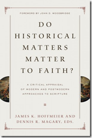
Several dozen helpful articles are included in the recent work edited by James K. Hoffmeier and Dennis R. Magary, Do Historical Matters Matter to Faith?: A Critical Appraisal of Modern and Postmodern Approaches to Scripture. In one of the articles, Michael G. Hasel addresses the lack of evidence for the United Monarchy in Israel. I thought that the points were worth sharing.

1. The heartland of the kingdom of David and Solomon is largely inaccessible to archaeologists because of the political situation in Judea and Samaria (the “West Bank”).

2. Of the sites excavated, many have not been fully published. Jerusalem is one such example.image%255B3%255D

3. Archaeological remains have faced massive destruction over the centuries.

4. The ancient peoples left limited texts to help us assess what they left behind.

5. Interpretations are tentative and can change within a season. Hasel cites the discovery of the Tel Dan Inscription against those who were then claiming that David and his kingdom were mythical.

For development of each point, see “New Excavations at Khirbet Qeiyafa and the Early History of Judah,” pages 477-96 in the book. For a full list of articles, see this previous post. The paperback sells for $23, and the Kindle version is under $10.

Share:

Here are two free lectures for those in the Chicago area. Apologies for such short notice.

American Research Center in Egypt – Chicago Chapter lecture.
Today, Feb. 2, Saturday at 5:00 pm.
Peter Brand, “All in the Family: The Royal Family of Ramesses II.”
The Oriental Institute of the University of Chicago, LaSalle Bank Room.
Website for details.

Oriental Institute lecture.
Feb. 6, Wednesday at 7:00 pm.
Elizabeth Stone, “City and Hinterland in ancient Mesopotamia: An
examination of continuities and developments in the fabric of urban and
rural settlement from 5,000 B.C. until the time of Christ.”
Free Registration required here.
Website for details.

Share:

Shmuel Browns has a roundup of interesting items he has discovered as a guide this week, and he’s soliciting suggestions for a name for the series.

Seth Rodriquez illustrates each region of the land of Israel.

The presentations from “Managing Archaeological Data in the Digital Age: Best Practices and Realities” are now online.

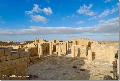
Nearly $2 million has been spent to restore the archaeological remains of the Nabatean city of Avdat after vandals attacked it.

The Cyrus Cylinder will make its first appearance in the U.S. on March 9 at the Smithsonian.

GigaPan has some extremely high-resolution panoramic images of Jerusalem.

HT: Jack Sasson, Michael Oliver

Avdat Byzantine Church of St Theodore, tb030607886
The Nabatean city of Avdat
Photo from the Pictorial Library of Bible Lands
Share: