fbpx

After reading Seth’s post yesterday on the interior passageway of Barclay’s Gate, Daniel Wright went looking and found some video taken in the same room.

This first video is a short clip of just that room, today the Mosque of Buraq (Muhammad’s horse).

This second video is a little longer and goes through other rooms underneath Al Aqsa Mosque. Here again the ancient spaces are put to use. In some places you can see Herodian stones. The video ends, I believe, with a walk through the “Double Gate” passageway.

These videos are valuable because very few non-Muslims are allowed to see these places.


Note: Those receiving this by email will need to click through to view the videos.

Share:

(Post by Seth M. Rodriquez)

This was a difficult week to come up with a photo to share.  The problem wasn’t due to a lack of good material … the problem was that there were too many good photos available!

This week’s photo comes from Volume 2 of The American Colony and Eric Matson Collection, which focuses on Jerusalem.  These are photographs of Jerusalem taken in the first half of the 20th century before many of the modern developments were built.  So much has changed in the city since that time (both physically and politically) that this volume is a gold mine of material for Jerusalem studies.

Here is a list of some of the photos I could have chosen for this week’s post:

  • The City of David when it was still being used for farmland.
  • A German zeppelin hovering over the Old City.
  • The interior of the Golden Gate on the Temple Mount.
  • The interior of the Double Gate on the Temple Mount.
  • The interior of Solomon’s Stables in the Temple Mount (but see here for a similar photo).
  • The interior of the Hurvah Synagogue before it was destroyed in the War of Independence.
  • The Pool of Hezekiah filled with water instead of trash (but see here for similar images).
  • Sealed entrances to the Church of the Holy Sepulcher.
  • The short-lived and aesthetically questionable clock tower built on top of Jaffa Gate (but see here for a previous post on that subject).
  • Remains of a Crusader-period monastery in the Kidron Valley, a small portion of which was only briefly excavated in 1937 and then buried again.
  • Crowfoot and Fitzgerald’s 1927-28 excavations in the City of David.
  • A smog-free landscape looking east which includes the Hinnom Valley, Mt. Zion, the Judean Wilderness, the Dead Sea, and the mountains of Moab.
  • The Jewish Quarter and the Western Wall as they looked before the War of Independence (but see here for a similar photo).

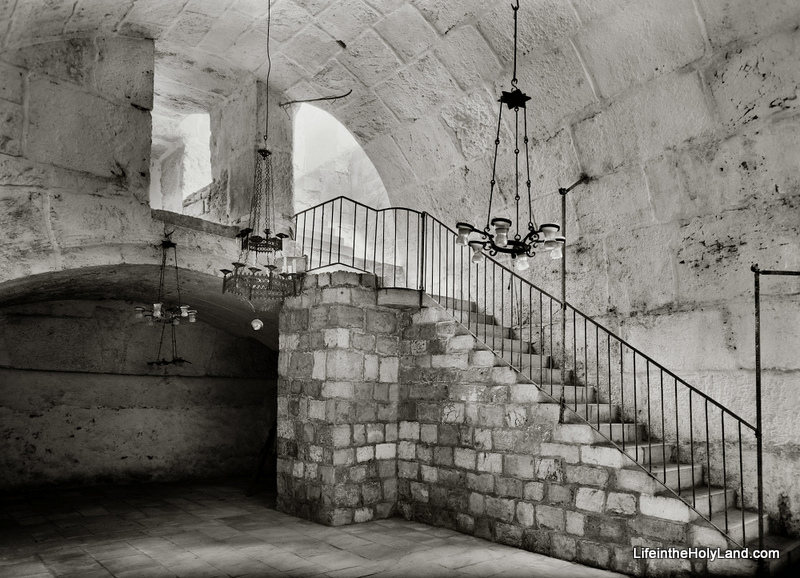
Instead, I will present the following rare photo of the interior of Barclay’s Gate (or at least the top section of the gate) on the western side of the Temple Mount, taken sometime between 1940 and 1946.


Barclay’s Gate was one of the entrances to the Temple Mount during the Second Temple Period (the time of Jesus and the apostles). A modern photo of the outside of Barclay’s Gate, in the women’s area of the Western Wall Plaza, can be seen here.  Only the stone that formed the lintel is visible today from the outside.  In the PowerPoint notes included in the collection, Tom Powers explains what we can see in the photograph above:

This fascinating photograph (looking northwest) shows a room lying beneath the surface of the Temple Mount (to Muslims, the Haram esh-Sharif, or “Noble Sanctuary”). This space was the subject of several descriptions and drawings by 19th century explorers but has rarely been seen by Westerners—or photographed. Much better known, actually, is the opposite side of the thick wall seen here at the end of the vaulted room: it is the massive lintel and blocked opening of an original western entrance of the Herodian Temple Mount, the so-called “Barclay’s Gate” partially visible in the very southern end of today’s Western Wall (women’s prayer area).  

The ancient gate was identified in modern times by James T. Barclay, an American Protestant medical missionary and amateur explorer of Jerusalem’s ancient places. In the course of recounting his identification of the exterior gate elements, Barclay also described the space pictured here: 

“During the period of my admission into the Haram enclosure I discovered in this immediate vicinity, on the interior, a portion of a closed gateway, about fourteen or fifteen feet wide; but whether it is connected with that on the exterior, I was not enabled to determine, for the guards became so much exasperated by my infidel desecration of the sacred room, el-Borak, where the great prophet tied his mule on that memorable night of the Hegira, that it was deemed the part of prudence to tarry there but a short time and never to visit it again . . . . Only the upper portion of the gateway can be seen—the lower part being excluded from view by a room, the roof or top of which is formed by the floor of this small apartment.”
— James Barclay, City of the Great King (1857), pp. 490-91 

In the passage quoted above Barclay, alas, garbles some elements of the Muslim tradition (he calls the mythical beast a “mule” and confuses Mohammed’s Night Journey with the hegira, his flight from Mecca to Medina). Nonetheless, his notion that this “small apartment” might be connected to the gate he had identified from the outside was correct, as confirmed by other explorers only several years later. Barclay was also correct that the mosque occupied only the uppermost part of the gateway. But, whereas Barclay presumed the existence of a lower room, the mosque actually overlies a great volume of debris deposits (or fill) behind the blocked gate. 

In this photo, the vaulting overhead is the top of the Herodian gate passage, and the dark line in the masonry of the far wall (beneath the shallow arch) corresponds to the bottom of the great lintel (apparently the lintel itself is not visible). Experts estimate the height of the Herodian gate opening, from sill to lintel, at 25 to 30 feet (7.8 to 9.3m), with the sill lying only a few yards (meters) above the Herodian street. Thus, in the original gate passage here, a broad stairway no doubt ascended (far beneath the floor shown here) toward the east and the surface of the Temple Mount. The original passage ran eastward from the western wall for at least 70 feet (22 m), but it was reconfigured and altered in many ways over the ages. For example, the distinctive arch of chamfered voussoirs (beveled and molded arch-stones) seen here, and others like it, point to a major redesign and rebuilding of the passage in Omayyad times (7th-8th centuries), when the gate was still open and in use. Since the Arab chronicler Al-Muqadassi in 985 still lists the gate (called by him, and all previous Arab sources, Bab Hitta) among the active entrances into the Haram, it must have gone out of use and was blocked sometime after that date. The eastern part of the passage was walled off at some point, plastered, and used as a cistern. 

The “al-Buraq” Mosque pictured here, again, is built into the vaulted internal gate passage of Barclay’s Gate, along the western wall and inside the Haram (Temple Mount) enclosure. It is situated immediately next to the Mughrabi Gate, to the north, and below the level of the Haram platform, from which it is accessed by the two flights of stairs pictured here. The Matson-supplied date for this photo is 1940 to 1946, and the mosque apparently still exists today. … 

This photograph and over 650 others are available in Volume 2 of The American Colony and Eric Matson Collection and can be purchased here for $25 (with free shipping).  Other historic photos can be seen on various pages of LifeintheHolyLand.com.  You can find the links the Jerusalem pages in the left column of the homepage.
Share:

Mark Hoffman comments on BibleX’s picture-taking tips and adds some suggestions of his own.


Time is reporting on Simcha Jacobovici’s lawsuit against Joe Zias. Aren Maeir isn’t happy with the article’s title: “A Feud Between Biblical Archaeologists.”

The Sea of Galilee is up to within 6 feet of capacity.

Raphael Golb’s appeal resulted in the vacating of one count and the affirmation of 30 other counts.

The NY Times is calling it “The Great Giveback,” as American museums hand over prized antiquities due to threats by foreign governments.

You can take a “virtual tour” of the tabernacle at the Creation Museum website. Click on this link and then select “The Tabernacle.”

The Dead Sea Scrolls are headed for Boston.

HT: Joseph Lauer, Jack Sasson, David Coppedge

Share:

Binyanē Ha-Umma (South): Finds included cooking pots from the first century, brick and roof tile debris from the Tenth Legion pottery workshop, and four coins.

Shu‛fat: A survey a couple of miles north of Damascus Gate identified 64 sites including an Iron II farmhouse, two Second Temple period tombs (one with a Latin inscription), nine tumuli, a Roman road, a large quarry, and more.

Mount Zion: An excavation was conducted in the courtyard south of the building that houses David’s Tomb and the Upper Room. The five strata excavated date from the Byzantine to the modern period.The excavation was prematurely halted at a depth of 5 feet when the archaeologists reached bones. “Further excavations will clarify if a massive wall from the fourth century CE was indeed exposed at the bottom of the trial square.”

The Old City, IDF House: Located along the Street of the Chain to the west of the Western Wall prayer plaza, this excavation identified primarily remains from the Ottoman period.

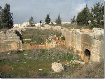
shuafat-quarry-iaa_thumb
Quarry in Shu’fat. Photo by IAA.
Share:

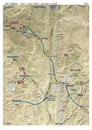
There is a fabulous new resource available that I’m delighted to be the first to tell you about. For the last four years when teaching seminary and church groups in Israel, I’ve had as the class guide an outstanding resource that nobody else could buy. I joked with my last group that this book cost $3,640 because they could only get it by coming with me on the trip. The other option was to enroll as a student in one of the short- or long-term study programs at The Master’s College’s campus in Israel for even more money.sba500 Today, for the first time ever, you can purchase your own copy of the Satellite Bible Atlas. This new work by Bill Schlegel replaces the venerable Student Map Manual but is superior to it in many ways. One obvious advantage is that you don’t have to spend 60+ hours marking it before it is usable! All the historical markings are printed in bright colors on top of satellite map imagery. Another advantage is that the commentary is on facing pages with the maps, so you have easy access to everything that is going on. If you want more, you can download the free, 200-page expanded commentary, The Land and the Bible: A Historical Geographical Companion to the Satellite Bible Atlas. This resource is ready for personal use, classroom use, and field trip use. The author, Bill Schlegel, has been teaching college and seminary students in Israel for 25 years. Everything in the Satellite Bible Atlas is field-tested by a professor who knows God’s land and loves God’s Word. Here are 7 more reasons I love the Satellite Bible Atlas: 1. The maps are full-size, full color, and full of rich detail of the hills, wadis, plains, and passes. 4.6-Gideon 2. There are 85 maps which means that every major historical event is covered, from Abraham to Paul. Too often the New Testament gets short-changed in atlases, but not here: the Satellite Bible Atlas has 9 maps for the life of Christ and 6 for the apostolic period. 3. The Satellite Bible Atlas includes 17 detailed topographical maps without historical markings. These are ideal for getting the best view of the terrain as well as both ancient and modern sites. 4. I fully trust the markings and the commentary. There are not many works in this field for which I can say that. 5. The north-orientation of the maps means there is no immediate learning curve as there was with the previous atlas we used which put east at the top. I put this atlas in the hands of my church group last year and they were immediately off and running. Several have commented to me in the last few weeks that they regularly use the Satellite Bible Atlas as they read the Bible. 6. The atlas comes with a free copy of all the maps in digital (jpg) format. You will receive a link to download the maps with your order confirmation. 7. For $30, plus $3 shipping and tax where applicable, you get an excellent atlas at an outstanding price. (For an additional discount on purchases of 10 or more copies, contact us.) Check out the sample maps, the table of contents, endorsements, teaching videos, and the free downloads. You can order here.

Share:

This is a series I should have done on this blog. But BibleX has done it first and quite well: Picture Taking Tips for the Holy Land, Part 1, Part 2, and Part 3. Thank you, Dr. Savelle.

The Shephelah is a great place to live. The ancients knew it and now modern people are catching on.

That’s bad for those who care about the preservations of ancient sites, as Luke Chandler explains in his well-illustrated post, Khirbet Qeiyafa to be Enveloped by City Expansion.

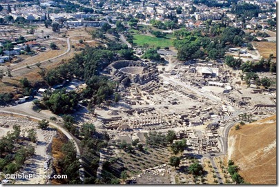
Beth Shean—A Place for Happy Explorers: Check out the photos, the video, and the city’s lingering lesson.

“Huge flocks of synchronized starlings that appear like a black cloud returned to Israel last year for the first time in 20 years.” This free Haaretz article includes impressive photos.

Jerusalem Online has a 4-minute video on The Search for Herod’s Grave. You can read the transcript at the same link.

The ancient Corinthians liked to feast, a fact confirmed by the recent excavation of more than 100,000 bones excavated in the abandoned theater.

The Guardian reports on Turkey’s on-going efforts to blackmail museums around the world.

For more, check out the Archaeology Weekly Roundup at the ASOR Blog.

HT: Joseph Lauer, Jack Sasson

Beth Shean aerial from northeast, tbs118210011
Beth Shean aerial from northeast.
Photo from Samaria and the Center.
Share: