fbpx

Shmuel Browns has photos of the Dome of the Chain now that the metal sheeting for renovations has been removed.

Lois Tverberg (“Our Rabbi Jesus”) suggests resources to help you learn about the life of a shepherd. I particularly like her first and last recommendations.

Leen Ritmeyer reports on the upcoming move of the Temple Institute in the Old City of Jerusalem.

Exploring Bible Lands has a great photo of the Jerusalem model (at the Israel Museum) covered with snow. You might want to subscribe to this newer blog while you’re there.

To return to familiar subjects, Leen Ritmeyer has photos old and new of Jerusalem in the snow.

A new book by Baruch Sterman, The Rarest Blue tells the 4,000-year-long story of the biblical blue tekhelet. Last week it was awarded the Book Prize for 2013 by the Jewish Journal.

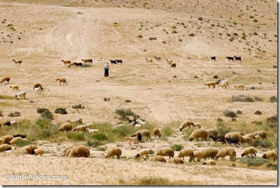
Shepherd with sheep near Sede Boqer, tb042007446
Shepherd with sheep in Negev Highlands
Photo from Cultural Images of the Holy Land
Share:

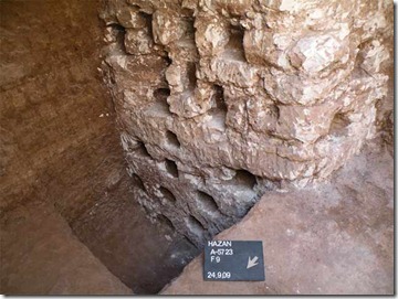
Horbat Hazzan and Horbat Avraq – A building from the late Iron Age was excavated along with several winepresses, columbaria, and a limekiln.

Jerusalem, Shuafat Ridge – Several miles north of ancient Jerusalem, archaeologists completed excavation of a farmhouse from the 8th-7th centuries BC.

Jerusalem, Qiryat Moriyya – Part of the low-level aqueduct that brought water to Jerusalem from Solomon’s Pools was exposed in Arnona.

Mount Tabor – An excavation near the Gate of the Winds revealed a portion of the Ayyubid fortification, built in 1212-1213 by the nephew of Saladin when the mountain was being contested by the Muslims and Crusaders.

Jaffa – Excavations of two areas in the modern flea market revealed a large pool “as well as pottery, glass vessels and coins dating to the Persian, Hellenistic, Late Roman, Byzantine, Early Islamic and
Crusader periods.”

iaa-columbarium-5723-8
Columbarium from area near Horbat Hazzan.
Photo by IAA.
Share:

(Post by Seth M. Rodriquez)

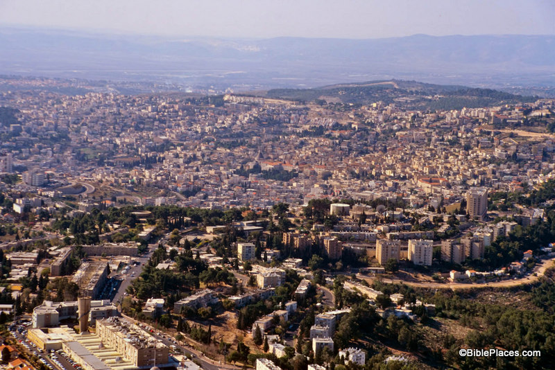
Why is it that the more important the biblical site, the more it tends to be surrounded by modern buildings?  Sites such as HazorMegiddo, and Gezer have a lower level of biblical significance (see 1 Kings 9:15) yet they are delightful places to visit because they are relatively untouched by modern developments.  But take a city like Jerusalem, Bethlehem, or Nazareth, and you need to hire a professional guide to help you find the ancient remains among the modern.

Take Nazareth for example.  I have been to Nazareth a number of times, but I have seen few (if any) ancient remains in that city.  It is completely covered by modern buildings.

Nazareth Today

This is not to criticize the modern inhabitants of the city.  They have a right to live there and build comfortable houses and reliable roads.  I am merely pointing out that often modern developments can diminish the usefulness of a location for teaching purposes.  This is why a site such as LifeInTheHolyLand.com and the resources available through that site are so helpful.

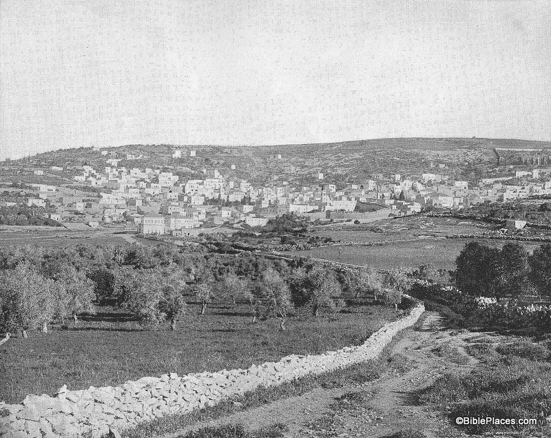
Our picture of the week comes from a book entitled Earthly Footsteps of the Man of Galilee, which has been reproduced in electronic form and is available through  LifeInTheHolyLand.com.  It contains nearly 400 photographs taken in 1894.  The book follows the life of Christ and the apostles chronologically, traveling back and forth through various countries.  Below is a picture entitled

“Nazareth from the East” and is followed by an excerpt from the book.  In this image, the city of Nazareth is much smaller than it is today.  The Nazareth of 1894 was probably much larger than the Nazareth of the 1st century, and yet this photograph provides a better impression of the Nazareth that Jesus knew than any modern photograph could hope to reproduce.

Nazareth in 1894

NAZARETH FROM THE EAST.–After an absence, according to Dr. Andrews, of something like six months, the Holy Family with the infant Jesus came in sight again of their own home.  If they approached the city from the East they would get the view, as far as the topographical features are concerned, given above.  Nazareth stands almost mid-way between the Jordan and the Mediterranean Sea, as we have already said.  It lies on the eastern slope of the hill, from the summit of which a magnificent prospect opens out.  Toward the north are the hills of Galilee and the majestic summits of the snow-crowned Hermon.  On the east is the Jordan valley and in dim outline the heights of the ancient Bashan.  To the south spreads the beautiful plain of Esdraelon, with Mount Tabor, Little Hermon and Gilboa; in sight, beyond, are the hills of Samaria, and on the west Carmel faces the blue waters of the Mediterranean.  No traveler should miss this view from the hill behind Nazareth.  It is perhaps the richest and most extensive in all Palestine.  The nearer hills are wooded, and drop in graceful slopes to broad and widening valleys of “living green.”  In the village below, upon this eastern slope, the Savior of the world passed his childhood.  His feet must frequently have wandered over these hills, and his eyes looked again and again from the summit as do the eyes of pilgrims now.  Here the Prince of Peace looked upon the great plain of Esdraelon, where had so often been heard the din of battle; and upon that sea over which the swift ships were to bear the tidings of his salvation to continents and nations then unknown.  The history of Nazareth seems to cluster about one remarkable event, “The Annunciation.”  Before that the place was unknown.  But to the Christian, Nazareth is the home of the Savior’s boyhood; the scene of his early labors, his prayers, his domestic relations, his whole private life for thirty years.  This gives unspeakable charm to the town.

Quote taken from John H. Vincent, James W. Lee, and R. E. M. Bain, Earthly Footsteps of the Man of Galilee (New York: N. D. Thompson Publishing, n.d.), p. 101, which can be purchased here.  The entire work contains almost 400 images, each with an explanatory note. Additional images of Nazareth can be seen here (1800s and 1960s) and here (modern day).

Share:

The first stage of the archive is now available online, but my first impression is not positive. The viewer is clunky and the server is slow. They’ve also made it difficult to save any of the files for personal study. Perhaps improvements will come; the project is certainly a worthy one. Here’s the full press release from the Israel Antiquities Authority:

The archaeological archive of Israel, which is administered by the Israel Antiquities Authority and amasses data on all of the activity of the archeological entities in the country, is computerized and will go online in the coming days. This is being underwritten with joint funding provided by the

“Landmarks” heritage program in the Prime Minister’s Office and the Israel Antiquities Authority.

The scientific archive has its beginnings in the British Mandatory Department of Antiquities. It was
continued by the Israel Department of Antiquities and is managed today by the Israel Antiquities Authority, which invests considerable thought and resources in its operation. [Yes, they really said that about themselves!]

The first stage, containing tens of thousands of documents, photographs, maps and plans from the years 1919–1948 from Akko and Jerusalem, is already available for viewing online at www.iaa-archives.org.il. Most of this material was written in English.

Uploading the old and valuable material to the website required special preparations. In order to scan the material, the Israel Antiquities Authority engaged the services of ImageStore Systems Ltd. This is because the archival material is especially delicate and sensitive and cannot be scanned with industrial equipment; rather it can only be done individually and manually. The documents in the archive include texts photographs, maps, and plans etc. on many different kinds of paper.

According to Israel Cabinet Secretary Zvi Hausner and Reuven Pinsky, director of the heritage project in the Prime Minister’s Office: “The Mandatory archive constitutes the principal foundation of archaeological research of the past one hundred years. This program, as part of the Israel Archives

Network project for scanning and digitalization of the material on file in the archives, will make it possible for the public in general and particularly scholars in Israel and abroad to access these resources of knowledge”.

According to Dr. Uzi Dahari, Deputy Director of the Israel Antiquities Authority, “The scientific importance of the archive is invaluable, and it is the only one of its kind in Israel and in the world. In Israel there are approximately 30,000 known and declared antiquities sites that constitute our cultural heritage – the largest and most important asset of the State of Israel. The Israel Antiquities Authority declares, treats, surveys, and researches the antiquities sites in the country. One of the many activities of the Israel Antiquities Authority is the management and running of the scientific archive. The Israel Antiquities Authority decided to transfer the archive to the digitalized media, in order to disseminate the information throughout the world”. To this end, all of the information was scanned and it was indexed according to rules that are suitable for research needs”.

According to Ephraim Reich, director general of ImageStore Systems Ltd., “We are proud to have been given the opportunity by the Israel Antiquities Authority to take a significant part in preserving this important information for the public. The utilization of advanced technology for the purpose of accessing enormous amounts of information that were stored until recently in libraries and archives not sufficiently accessible to the average user is a matter of utmost importance to ImageStore Systems Ltd. We are confident that this work will help preserve this important archival material for our benefit and that of future generations”.
iaa-jerusalem-aerial
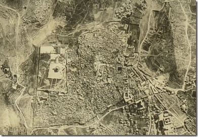
Aerial photograph of Jerusalem, undated. From the Archaeological Archive of Israel.
Share:

From Arutz-7:

The Temple Institute moved a giant copper laver, or wash basin, to the new home of its exhibit of Temple articles on Monday. A statement by the Temple Institute said the basin, which is 2.5 meters (8.2 feet) tall and 2.8 meters (9.1 foot) in diameter is kosher for use in the Third Temple and can be used to purify 12 priests at once. The statement also said the new basin has advanced systems that make it possible to overcome certain problems in Jewish law, as was done at the time of the Second Temple.

See the full article for a photo. For more information about the background of the construction of the laver, see the website of the Temple Institute.

Share:

Arutz-7 reports on the theft of a vessel from Shiloh discovered a week ago.

An ancient vase that provided evidence that Shilo was sacked by Philistines has been stolen from the Shilo site. Avital Sela, who manages the site, told Arutz Sheva that once the vase was discovered to have been stolen, a complaint was filed with police. Sela explained that the vase, which was dated precisely to the year in which the destruction of Shilo was assumed to have taken place, "connected all of the Biblical pieces into one puzzle."

The full story is here.

Share: