fbpx

Luke Chandler:

I’ve used Todd Bolen’s Pictorial Library of the Bible Lands collection for several months. I’ve tried it with Bible classes, history classes, sermons, etc. and my conclusion is…
Wow.
I posted on the new expanded set a few months ago before I had actually obtained it. It was clearly a useful product. Now that I’ve used it, I can’t imagine life without such a valuable, enriching tool.
The Pictorial Library set includes some 17,500 photos of nearly everything you could imagine in the Bible Lands. For me, the best part is the 400+ PowerPoint presentations included with the set. The PowerPoint files contain all of the photos ready-to-go. They are organized by location and contain great slide notes that inform and complete your presentation.

You can read all of Luke’s assessment at his blog.

You can learn more about the new Pictorial Library of Bible Lands here, download a free PowerPoint presentation of Caesarea here, and place an order here. Individual volumes cost $24-$39. The complete set of 18 volumes is now marked down to $389 (a 35% discount). Larger discounts are available for upgraders.

BiblePlacesProduct-PLBL

Share:

(Post by Seth M. Rodriquez)

Having worked through the revised and expanded edition of the Pictorial Library of Bible Lands in this series, we will begin highlighting pictures in a lesser known (but extremely fascinating) series called Historic Views of the Holy Land.  This is a sister collection to the PLBL and is featured in a website called LifeInTheHolyLand.com.

Here is a brief description of the series from the website:


The Historic Views of the Holy Land series is an extensive collection of thousands of photographs, drawings, and maps of the biblical lands from the 19th and 20th centuries.   


The collection, upon which this website is based, features  

  • the most detailed and accurate maps of Palestine made before the birth of the state of Israel  
  • pictures from award-winning photographers who traveled through Egypt, Palestine, Lebanon, Syria, Turkey, and Greece in the 19th century  
  • photographs and drawings which illustrate biblical scenes, including Psalm 23, the Good Samaritan, and the Woman at the Well.

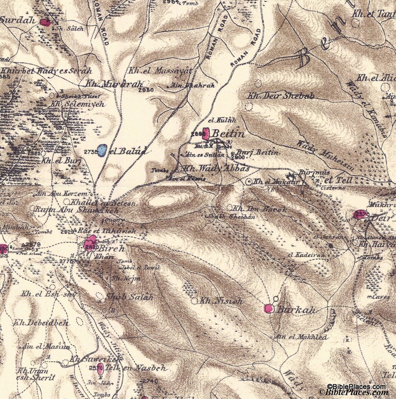
The first bullet point relates to our “Picture of the Week.”  These are the maps created by the Palestine Exploration Fund in the 1870s and published as the Survey of Western Palestine.  The maps contain an amazing amount of detail, were the most accurate maps produced in its day, and were created before the massive political and cultural changes were made in the country during the 20th century.  Produced at a scale of 1 inch to 1 mile, these maps are a treasure trove for students and scholars interested in biblical geography.  A full explanation of the maps and their value can be found here.

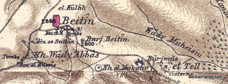
Our picture this week focuses on one small area of the maps: the region of Bethel and Ai.

This section shows Beitin as a pink oval in the upper center of the map, which is usually identified as Bethel. It also shows et Tell in the right center and Khirbet el Mukatir to the east of et Tell.  The city of Ai (Gen. 12:8; Josh. 7:2) is identified by many scholars as et Tell, but the Associates for Biblical Research have been conducting excavations at Khirbet el Mukatir over the last couple of decades to investigate the possibility of identifying that site as Ai instead.  Below is an enlargement of the section of the map that shows Beitin, Kh. el Mukatir, and et Tell so that you can see the relationship between the three sites (click on the picture for a higher resolution):

This is just one example of the many uses of the Survey of Western Palestine Maps.  The originals of these maps are not easily accessible in libraries, but the electronic versions are available to all through the Historic Views of the Holy Land collection.

Further information and other images of the Survey of Western Palestine Maps can be found here.  You can download the index to the maps for free here, and you can purchase the maps by visiting here.  For another example of how these maps can be used, see my post on the Wild Olive Shoot blog here.

Share:

As you might have guessed, one afternoon is all the time they need to discuss the contributions of Robert Alexander Stewart Macalister. From the Agade list:


R.A.S. Macalister’s Contributions to the Archaeology of Palestine 100 Years Later: An Evaluation

Workshop to be held at the W.F. Albright Institute of Archaeology, 26 Salah ed-Din Street, Jerusalem on Thursday, December 13, 2012

1:15 Light refreshments

1:30 Welcome and Introduction, Sam Wolff, Israel Antiquities Authority and Albright Institute


Tel Gezer

1:40 Jonathan Tubb, Keeper, Middle East, The British Museum, R.A.S. Macalister: Villain or Visionary?

2:10 William H. Dever, Professor Emeritus, University of Arizona, A Response to Jonathan Tubb (to be read by S. Gitin)

2:25 Baruch Brandl, Israel Antiquities Authority, Are the Finds from Macalister’s Gezer I-III Still Relevant for Current Research a Century Later?

2:40 Tsvika Tsuk, National Parks Authority, Digging in Macalister’s Footsteps: The Gezer Water System

3:00 Eric Mitchell, Southwestern Baptist Theological Seminary, The Gezer Survey: An Assessment of Macalister’s Work (to be read by S. Wolff)

3:15 Discussion

3:30 Break


Jerusalem and Judean Shephelah Sites

3:45 Shimon Gibson, University of the Holy Land R.A.S. Macalister: with Bliss at Tell el-Judeideh
and with Duncan at Jerusalem

4:15 Oded Lipschits and Yuval Gadot, Tel Aviv University “Kabdehu veChasdehu” (“Respect Him but Suspect Him”): Digging Azekah after 113 Years

4:30 Amos Kloner, Professor Emeritus, Bar-Ilan University Subterranean Complexes at Mareshah and Additional Notes on the Judean Shephelah Hiding Complexes

4:45 Aren Maeir, Bar-Ilan University and Rona Avissar, Albright Institute, Bliss and Macalister’s Work at Tell es-Safi: A Reappraisal in Light of Recent Excavations

5:00 David Ussishkin, Professor Emeritus, Tel Aviv University and Ronny Reich, University of Haifa, concluding remarks, followed by discussion

The workshop is open to all interested scholars. Please RSVP your intention to attend to Sam Wolff (sam at israntique.org.il).

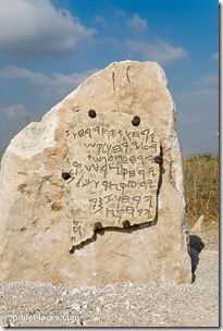
Gezer Calendar large replica, tb070506092
A replica of the Gezer Calendar, found in the Macalister’s excavation dump
Share:

A press release from the American Friends of Tel Aviv University announces the recent discovery of a holy place that was not always a holy place.

Tel Aviv University researchers have uncovered a unique 11th-century BCE sacred compound at the site of Tel Beth-Shemesh, an ancient village that resisted the aggressive expansion of neighboring Philistines. The newly discovered sacred complex is comprised of an elevated, massive circular stone structure and an intricately constructed building characterized by a row of three flat, large round stones. Co-directors of the dig Prof. Shlomo Bunimovitz and Dr. Zvi Lederman of TAU’s Sonia and Marco Nadler Institute of Archaeology say that this temple complex is unparalleled, possibly connected to an early Israelite cult — and provides remarkable new evidence of the deliberate desecration of a sacred site.
[…]
After ruling out the use of the site as a domestic structure, the researchers knew that they had found something unique. Excavations revealed almost only shards of painted chalices and goblets found spread on the floor but no traces of domestic use. One of the three flat stones was surrounded by animal bone remnants, and the two other stones were seemingly designed to direct liquids. These clues convinced Prof. Bunimovitz and Dr. Lederman that they had uncovered a likely place of sacred worship.
But the temple didn’t remain sacred. Samples of earth taken from layers above the destroyed temple and analyzed at the Weizmann Institute of Science revealed astonishing results. Directly above the temple was a packed-in layer containing phytoliths (remains of weeds that are commonly eaten by livestock) and spherulites (microscopic remnants of manure produced by grass-eating animals), indicating the presence of animal pens directly on top of the sacred site, explains Prof. Bunimovitz. Intermittent burning in order to clean the pens likely resulted in the concentrated state of the layer.
This desecration was no accident or coincidence, the researchers believe. Instead, it represents the see-saw of political might between the Philistines and the local population. Presumably the Philistines gained temporary control of Beth-Shemesh, and brought in livestock to live on what they knew had been a sacred site to their enemies.

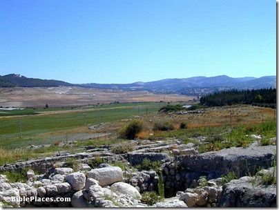
The article does not mention Samson, but this is roughly the period when he lived in the town across the valley.

HT: David Coppedge

Zorah and Eshtaol from Beth Shemesh, tb062300343
View from the excavations of Beth Shemesh towards Samson’s place of birth and burial
Share:
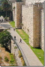
Jerusalem Old City western wall, tb051908285

The title of this article at the Jerusalem Post will get your attention, but it’s a bit misleading. If you think of it primarily as ways to leave Jerusalem, it’s more accurate. The top 5 are:

  • Segway
  • ATV
  • Bike Tours
  • Jeep Tours
  • Horse-riding
The article gives more details and includes phone numbers. If you want to see Jerusalem, you really need to walk.

HT: Charles Savelle

Share:

The Associated Press reports on the Carchemish excavations. Six photos are featured. (A version with photos embedded is here.)

NT Blog: The Jesus’ Wife Fragment: How the Forgery Was Done

Logos Bible Software, my Bible study program of choice for more than 15 years now, has released version 5. The Biblical Studies and Technological Tools blog is reviewing it. In Part 1, Mark Hoffman provides excuses for upgrading, and in Part 2, he gives reasons, with plenty of illustrated examples.

Eisenbrauns’ Deal of the Weekend is Exploring the Longue Duree: Essays in Honor of Lawrence E. Stager. Don’t let the title fool you: there are many interesting articles in this book. (Click on the Table of Contents link for a full list.)

Share: