fbpx

(Post by Seth M. Rodriquez)

Perhaps the most curious volume in the revised and expanded Pictorial Library of Bible Lands is the last one: Volume 18, “Signs of the Holy Land.” If you have never visited the Holy Land, then you don’t know what you’re missing! If you have been there, then you can imagine what humorous (and not-so-humorous) signs you can find in this collection.

It goes without saying that English is not the primary language of any of the biblical regions today, so the charm of many of these signs lies in the fact that the grammar, spelling, and choice of words are frequently not the most eloquent. “This Holly Church,” “Danger of Death,” “You Are Hear,” and “Bewar of Loose Rocks” are just some of what you will find when you visit the Holly Land … I mean, Holy Land.  Or perhaps you will run across this one:

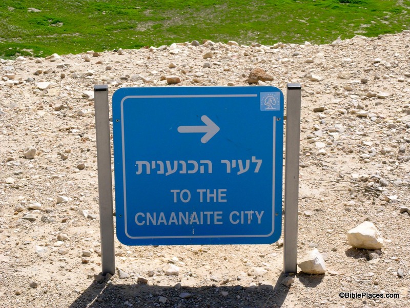
With directions like these, it’s no wonder the Israelites had to wander in the wilderness for 40 years. (How do you even pronounce that?!)

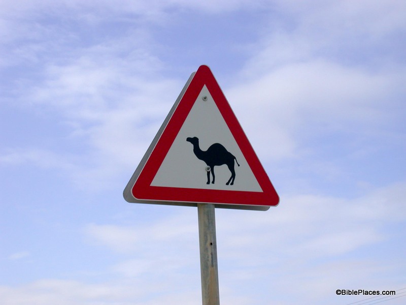
Another source of their charm is in the cultural differences that they reveal. Some of these differences are rather serious: such as signs requiring modest clothing in certain areas, signs warning you of a mine field, or signs of Jews denouncing Arabs or of Arabs denouncing Jews. But some of these are quite humorous, such as “Temptation Restaurant” in Jericho (near the traditional Mount of Temptation), signs forbidding honking, an advertisement for windsurfing on the Sea of Galilee, and “Do not play soccer on the grass!” (You can just hear the municipality’s frustration with the local youth in that last one.) Or, one of my personal favorites, this sign for a camel crossing taken by Daniel Frese:

Perhaps we are not as far removed from the time of Abraham as we think we are.

Yet much of their charm comes from the fact that these are modern signs that often reference biblical people, places, and events. One of the values of visiting the Holy Land is that it helps you connect with the Bible in a unique way because you are there. You are in the same place where the drama of the Bible unfolded. Seeing road signs that reference the cities of Jerusalem, Bethlehem, Jericho, Nazareth, Tarsus, or Corinth drives home the point that you are in the land of the Bible. You also will see streets and shops named after biblical events or people. 

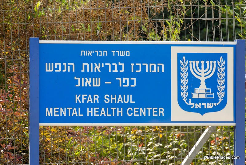
Much of this volume of the PLBL is devoted to such signs. Biblical people, places, and events are part of the lifeblood of these cultures and this is evident in how they name things. Most of the time, these references are intentional and add dignity to a place. However, I’m not sure that the people who named the “Kfar Shaul (Village of Saul) Mental Health Center” really thought through all the biblical associations:

If only this place had existed in Saul’s day then maybe he wouldn’t have needed to hire David to play music for him (1 Sam. 16:14-16).

There are so many interesting signs in this collection that I couldn’t narrow it down to just one for this post, so once again I broke tradition by giving you three. And although this volume may be one of my personal favorites, you may be wondering, “What in the world would I use these pictures for?” So here are some ideas for you …

  • Ice Breakers for a Lesson or Sermon
  • Teaching Illustrations
  • Humor
  • Attention Grabbers
  • Demonstrating the Relative Geographical Location of One Site to Another (using highway signs)
  • Hebrew or Arabic Vocab Lessons and Tests (gleaned from real-life examples)
  • Lessons in Jewish and Arab Culture
  • Decorative Art for a Bulletin or Brochure

I’m sure the readers of this blog can think of more uses than that, and you are welcome to leave your ideas in the comment section. Until next time … drive safely, watch out for passing camels, and (as one sign in Cyprus puts it) remember that “Driving in the lake is forbidden.”

These and other photos of “Signs of the Holy Land” are included in Volume 18 of the Pictorial Library of Bible Lands and can be purchased here.

Share:

From the IAA press release:

A rare well dating to the Neolithic period was uncovered in recent excavations the Israel Antiquities Authority carried out at ‘Enot Nisanit’, along the western fringes of the Jezreel Valley prior to enlarging Ha-Yogev Junction (Highway 66) by the National Roads Company. Archaeologists estimate the well was built approximately 8,500 years ago.
During the excavations the skeletal remains of a woman approximately 19 years of age and a man older than her were uncovered deep inside the well. How did these come to be in the well? Was this an accident or perhaps murder? As of now the answer to this question remains a mystery.
According to Yotam Tepper, excavation director on behalf of the Israel Antiquities Authority, “What is clear is that after these unknown individuals fell into the well it was no longer used for the simple reason that the well water was contaminated and was no longer potable”. Tepper adds, “The impressive well that was revealed was connected to an ancient farming settlement and it seems the inhabitants used it for their subsistence and living. The upper part of the well was built of stones and its lower part was hewn in the bedrock. Two capstones, which narrowed the opening, were set in place at the top of the well. It is c. 8 meters deep and its upper part measures about 1.3 meters in diameter”.
Tepper says, “Numerous artifacts indicating the identity of the people who quarried it – the first farmers of the Jezreel Valley – were recovered from inside the well. The finds include, among other things, deeply denticulated sickle blades knapped from flint which were used for harvesting, as well as arrow heads and stone implements. The excavation of the accumulations in the well shaft yielded animal bones, organic finds and charcoal which will enable future studies about the domestication of plants and animals, and also allow researchers to determine the exact age of the well by means of advanced methods of absolute dating”.

‘Enot Nisanit is located one mile north of Tel Megiddo. The full press release and six high-res photos are here.

UPDATE: The story is being reported, with some sensational titles, in the Jerusalem Post, Arutz-7, The Times of Israel, and Reuters.

HT: Joseph Lauer

4
Well discovered in Jezreel Valley. Photo by Yotam Tepper, courtesy of the Israel Antiquities Authority.
DSC_3702
Skeletal remains discovered inside well. Photo by Clara Amit, courtesy of the Israel Antiquities Authority.
Share:

Excavations are underway now at ancient Carchemish. We’ve commented on the plans previously here.

I really like how Wayne Stiles takes our photos and creates beautiful articles that explain the biblical history so well. This week he writes about the tabernacle at Shiloh.

James Davila points to a new article on the metal codices from Jordan and explains why he thinks they’re still fake.

Caspari Center Media Review: Jerusalem’s local conservation committee rejected plans to build a four-story hotel next door to Mary’s Well in the pastoral village of Ein Karem. Those who opposed the plan said that the construction posed a great risk to the well, which, according to Christian tradition, is where Mary the mother of Jesus bathed. “The water from the well is considered holy for Christians and pilgrims from all over the world come to this place to fill up bottles with water from the well. … Damaging the well would be very harmful to the country.”

HT: Jack Sasson

Shiloh from east, tb120806865
Shiloh, home of the tabernacle
(photo from the Pictorial Library of Bible Lands)
Share:

Archaeologists have long known about some ancient cedar beams on the Temple Mount. Recent tests indicated that they dated back to the time of Solomon’s temple. (I don’t have an English reference for that at the moment.) The Temple Mount Sifting Project team recently wrote about these cedar beams:

Some of these beams predate the first Al-Aqsa Mosque and have been used and reused numerous times in various structures, which actually aided their preservation. We have some fragments of these beams among the finds at the Sifting Project.
We have been monitoring these beams for many years as they lay exposed to the weather in the open courts of the Temple Mount. We hope the Israel Antiquities Authority will succeed in placing them in a safe shelter before the coming winter. We have been requesting that the IAA deal with this issue more than three years, but these ancient beams have yet to be properly secured.

Arutz-7 reported on Sunday that some of the beams are being used as firewood.

The wood, consisting of giant beams, first appeared at the end of the 1930s, when the Al-Aqsa mosque which currently occupies the Temple Mount was refurbished. The beams had been used in the roof structure of the mosque, and already at that time they were said to be thousands of years old by archaeologists – preserved only because they had been used in the building. Some of the beams were dated to the first Temple period, others to Roman times, and at least one beam was found to have Byzantine-era designs etched on it.
[…]
Now, many of the beams have been placed at what appears to be a dumping ground next to the Golden Gate of the Old City, apparently for the use of local Arabs as firewood. Jewish groups that visited the Mount saw the beams being moved, but reported that the Arabs forbade them to take photos of the activity. Officials of the Archaeology Authority, who are responsible for the safety of these ancient beams, are nowhere to be seen.

The Arutz-7 story includes a short video allegedly showing the beams being burned next to the Golden Gate.

Cedar of Lebanon, adr090510661

Cedar trees in Lebanon
Photo from the new Lebanon volume
Share:

You can read or download the last three years of Palestine Exploration Quarterly for free with a simple registration, for a limited time. You can see the table of contents here. The issues from 2009-2011 appear to be free without registration from the table of contents. Here are a few recent articles that caught my eye:

What Would the Egyptian Pharaoh Shoshenq I Have Seen If He Had Visited the Central Jordan 
Valley?, by Lucas P. Petit.peq

Palestinian Antiquities Looters, Their Skill Development, Methodology And 
Specialised Terminology: An Ethnographic Study, by Salah H. Al-Houdalieh.

The Location of Ziklag: A Review of the Candidate Sites, Based on Biblical, 
Topographical and Archaeological Evidence, by Horton Harris.

The Location of Tarichaea: North or South of Tiberias?, by Nikos Kokkinos.

The Protestant Garden Tomb in Jerusalem, Englishwomen, and a Land Transaction in Late Ottoman Palestine, by Ruth Kark and Seth J. Frantzman.

Members of the Palestine Exploration Fund receive four issues of PEQ a year (as of 2013) as well as other privileges.

UPDATE (11/10): They changed the free access noted above. You should still be able to get to the content by registering for their free and informative mailing list.

Share: