fbpx

Nir Hasson writes of Israel’s efforts to survey the whole country for any signs of man-made activity from the past. Archaeologist Adam Zertal has worked on the survey for the last 34 years and is the focus of the report in Haaretz.

“It could be said there isn’t a meter we haven’t covered,” says Prof. Zertal, who walks using crutches, a remnant of an injury from the 1973 Yom Kippur War. “Walking is my rehabilitation. I walk slowly with crutches. The younger guys go much faster.”
This is how the national archaeological survey, one of Israel’s longest-running scientific projects, is being carried out. The aim is to clamber down every ravine, scale every hill and walk through every furrow in the country.
The Israel Antiquities Authority seeks to precisely map every historical and archaeological site west of the Jordan. The project, which began in 1964, is due to end – if at all – in a few decades.
Six years ago the authority stopped publishing thick volumes of the survey’s results; it now uploads the data onto the Internet. It recently launched a revamped website containing 3,000 archaeological sites out of the 25,000 sites mapped to date in half the country.

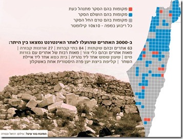
The Hebrew version of the article has several illustrations, and Joseph Lauer has provided the legend for the survey map:

Red- Active survey sites

Blue – Completed survey sites

Grey – As-yet unsurveyed sites 

Each square on the map – 10 x 10 kilometers

Map-468
Illustration from Haaretz

The IAA website has more details about the survey’s progress and goals. The online database with the 3,000 sites is available here.

I recently compiled, with the help of some friends, a preliminary bibliography of archaeological surveys of Israel and Jordan published in the last few decades. If you know of any additional works, please let me know and I will update the list. The Hebrew publications for the regional surveys are given here.
Share:

Charles Jones has put created an excellent Roundup of Resources on Ancient Geography. Bookmark this one!

There are enough scholars who have serious doubts about the authenticity of the “Gospel of Jesus’ Wife” that when a report circulated that Harvard Theological Review had decided to not publish the article, many scholars believed it. Brian LePort has some of the back and forth.

Mark Hoffman excavated at et-Tell (Bethsaida?) this summer and is sharing his photo book of the dig. (No account is needed to flip through it, and full screen provides the best view.)

Jodi Magness is interviewed in the WAMC Academic Minute about her excavations of the Huqoq synagogue.

Cornell University has received a $200,000 grant from the National Science Foundation for dendrochronology and radiocarbon dating research in the Near East.

A conference at Tel Aviv University in late October will focus on Ancient Greece and Ancient Israel:
Interactions and Parallels (10th to 4th Centuries BCE). The details are available here.

SourceFlix’s latest short is called “Fishers of Men.”


Biblical Archaeology Review is now available as a digital subscription, with the bonus that you get last year’s digital issues.

Robert Mullins gives a day-by-day account of the first season at Abel-beth-maacah. His excitement is justified.

HT: Joseph Lauer, Jack Sasson

Abel Beth Maacah from northwest, tb062900201
Abel Beth Maacah from the northwest
Photo from Pictorial Library of Bible Lands
Share:

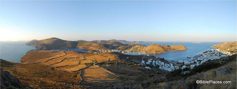
This week’s photo focuses on what is arguably the last of the “Bible Places.”  If the Garden of Eden is the first Bible Place, the island of Patmos could be considered the last. 

Our picture of the week comes from Volume 12 of the revised and expanded version of the Pictorial Library of Bible Lands, which focuses on the Greek Islands.  The photo is entitled “Patmos, View of Island North from Acropolis Panorama” (picture ID # tb061606331).  If you have this volume, the photo can be found in the Microsoft PowerPoint presentation on Patmos.  This photo is one of several beautiful panoramas that are available as part of the PLBL.  (Click on the photo for a higher resolution.)

Why is this the last of the Bible Places? The small island of Patmos is where John received his heavenly visions which were later written down in the last book of the Bible: the book of Revelation.  In Revelation 1:9 the apostle writes, “I, John, your brother and companion in the suffering and kingdom and patient endurance that are ours in Jesus, was on the island of Patmos because of the word of God and the testimony of Jesus” (ESV).

Patmos is a small island: only 7.5 miles long and 6 miles wide. To walk from one end to the other would take only a few hours.  It is situated between modern Turkey and Greece, and is a volcanic island with rocky soil. The island was settled on and off throughout the centuries. During the Roman period, there is evidence that there was a temple to Artemis and a gymnasium there, so it is unlikely that John was alone during his stay. According to the notes in the PLBL, there have been over 300 churches built on the island over the last 2,000 years. With only 13 square miles of real estate, that means there has been an average of 23 churches per square mile!

 
But is this really the last of the Bible Places?  After all, there are still 22 chapters of scripture after Patmos is mentioned in chapter one. Within these chapters, several other locations are mentioned, such as Ephesus (Rev. 2:1), Sardis (Rev. 3:1), and Laodicea (Rev. 3:14). Yet Patmos is the last identified location of an apostle mentioned in scripture, so that counts for something. 😉 Mount Zion is mentioned in Revelation 14:1, but is this referring to the hill called Mount Zion during biblical times or the modern Mount Zion that was mislabeled by the Byzantines? Until the jury weighs in on that issue, Mount Zion is disqualified. “Babylon” is the focus of Revelation 17 and 18, but Bible scholars are divided about whether that refers to actual Babylon, to Rome, or to something else entirely, so that option should be ruled out. Some people probably would argue that the prize for the last Bible Place should be awarded to the new heaven and the new earth described in Revelation 21 and 22, but unfortunately John did not take any photographs for us and we can’t take tourists there, so that’s not really practical.  So in the end, with our tongue planted firmly in our cheek, we award the illustrious prize of the last BiblePlace to the tiny (yet significant) island of Patmos!
 
This and other photos of Patmos are included in Volume 12 of the Pictorial Library of Bible Lands and can be purchased here.  More information on Patmos and additional photos can be found on the BiblePlaces website here.  For a more serious reflection on the biblical significance of the island and how this may have influenced John’s description of the new creation in Revelation 21:1, check out my post at the Wild Olive Shoot blog here.
Share:

Today is Yom Kippur and I suggest you read Wayne Stiles’ lavishly illustrated article on the tabernacle and its significance for the Day of Atonement.

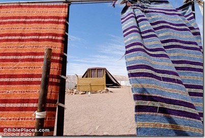
A full-scale replica of the Tabernacle stands in the very wilderness where Moses and the children of Israel wandered for forty years.
It is like entering a doorway to history—and viewing a picture of your salvation.
Reading the Tabernacle’s dimensions in Exodus 35-40 is so different from seeing them with your own eyes—and in the same wilderness where the Tabernacle stood (Exodus 40:34-38).
The realistic replica echoes of Yom Kippur—the Day of Atonement—when God forgave the sins of His people.

Read the full article here.

Tabernacle model from outside courtyard, tb030807084
Tabernacle replica at Timna Park
Share:

Readers here may be familiar with Jodi Magness from The Holy Land Revealed DVD course, her award-winning book The Archaeology of Qumran and the Dead Sea Scrolls, or her recent excavations of a synagogue at Huqoq.

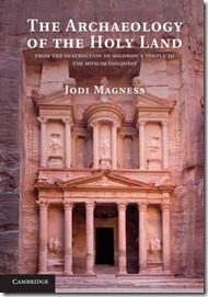
Cambridge University Press has just released a new archaeological survey by Magness, The Archaeology of the Holy Land: From the Destruction of Solomon’s Temple to the Muslim Conquest.

According to the preface, Magness has wanted to write this book for more than 20 years.

The book has 17 chapters, including these:

2. The Topography and Early History of Jerusalem (to 586 B.C.E.)magness-archaeology-of-the-holy-land-from-the-destruction-of-solomons-temple-to-the-muslim-conquest

7. The Early Roman (Herodian) Period (40 B.C.E.—70 C.E.): Jerusalem

8. The ERP: Caesarea Maritima, Samaria-Sebaste, Herodian Jericho, and Herodium

9. The ERP: Jesus’ Birth and Galilean Setting

10. The ERP: Masada

11. Ancient Jewish Tombs and Burial Customs (to 70 C.E.)

The hardcover is not fairly priced, but the paperback is affordable ($28). Amazon has the “Look Inside” feature enabled, so you can get a feel for the text, maps, sidebars, and recommended readings.

Share:

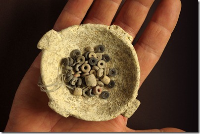
Excavations along a highway in northern Israel revealed a 50-acre site dating to the Neolithic period. One of the most impressive discoveries was a small stone bowl with several hundred stone beads.

Among the special finds that were uncovered in the excavation is a group of small stone bowls that were made with amazing delicacy. One of them was discovered containing more than 200 black, white and red stone beads. Other important artifacts are clay figurines of animals (sheep, pig and cattle) that illustrate the importance of animal breeding in those cultures. The most importance finds are stone seals or amulets bearing geometric motifs and stone plaques and bone objects decorated with incising. Among the stone plaques is one that bears a simple but very elegant carving depicting two running ostriches. These objects represent the world of religious beliefs and serve as a link that connects Ein Zippori with the cultures of these periods in Syria and Mesopotamia. According to Milevski and Getzov, “The arrival of these objects at the ʽEin Zippori site shows that a social stratum had already developed at that time that included a group of social elite which used luxury items that were imported from far away countries”.

The full press release is here, and three high-resolution images are also available. The discovery is reported by the Jerusalem Post and Haaretz.

DSC_1523

Photo by Clara Amit, courtesy of the Israel Antiquities Authority
Share: