The next time you hear someone talk about the “science” of archaeology or how some discovery (or lack of discovery) has proved or disproved this or that biblical claim, you may want to consider the words of one of Israel’s senior archaeologists, Amihai Mazar: “The interpretation of archaeological data and its association to the biblical text is a veritable minefield, as it is often inspired by the scholar’s personal attitude towards the text . . . we face over and over again arguments that, at their core, are circular. This was as true at the time of William F. Albright and his followers as it is today. There are few items of data in the archaeological record that are not disputable.” Source: Amihai Mazar, “The Spade and the Text: The Interaction between Archaeology and Israelite History Relating to the Tenth-Ninth Centuries BCE,” in Understanding the History of Ancient Israel, ed. H. G. M. Williamson, Proceedings of the British Academy, vol. 143 (Oxford: Oxford University Press for The British Academy, 2007), 145.
If I asked my readers for the top volume on archaeology of Israel from the Old Testament period, my guess is that most would  choose Amihai Mazar’s Archaeology of the Land of the Bible: 10,000–586 BCE. Those who didn’t select it would likely at least recognize the title of this best-selling work for the last two decades. I would guess that fewer readers would be familiar with the second volume in the series. Ephraim Stern’s Archaeology of the Land of the Bible, Volume II was released in 2001 and covers the years 732 to 333 BC. Though this is also a period
  of Old Testament history (from Hezekiah through Nehemiah), my sense is that not as many people know of or own this book. At $60, the casual reader will be turned away. The third volume in the series has just been published, but the volume’s title and cover do not clearly communicate its relationship with Mazar’s and Stern’s volumes. Alexander to Constantine: Archaeology of the Land of the Bible, by Eric M. Meyers and Mark A. Chancey, is the third in the trilogy, carrying the archaeological survey forward from the Hellenistic to the Late Roman periods. Brief chapters at the beginning and end address the Persian and Byzantine periods, but the focus is on the 1st centuries BC and AD, as can be seen by these chapter titles: 3. Herod the Great and the Introduction of Roman Architecture (33 pages)
 4. Khirbet Qumran and the Dead Sea Scrolls (30 pages) 5. From Herod to the Great Revolt (26 pages) 6. The Great Revolt and the Bar Kokhba Rebellion (35 pages) 7. The Emergency of Christianity (29 pages) The book arrived a few days ago and so I haven’t yet read it, but an initial review suggests that it will be an ideal survey of the archaeological finds from these periods for several reasons:
- Eric M. Meyers is a distinguished scholar with decades of experience in field archaeology in these periods.
- At just under 300 pages (excluding endnotes and indices), this work covers the essentials but will not overwhelm the reader.
- The book is lavishly illustrated with photos, maps, and reconstructions. I would estimate that there are more than 100 illustrations.
To conclude, if you are looking for a readable and up-to-date survey of the archaeological record from about 300 BC to AD 300 written by leading scholars in the field, I would start with this one. At the moment, Amazon is listing it as a pre-order with a discount of 44% off ($40 marked down to $22.52). In my experience, prices marked down this much during pre-order increase upon release.
Archaeologists have found a collection of right hands at the Hyksos capital of Avaris in Egypt. Collecting body parts was one ancient way of counting victims (cf. 1 Sam 18:25). Israeli scientists have developed a way to predict the location of sinkholes near the Dead Sea. Clay rods from the Neolithic period found years ago are not phallic symbols but were ancient matches for starting fires. A summary of the 13th season at Hippos/Susita has been released by the University of Haifa. There are more photos here. A large olive press from the 6th-8th centuries AD has been discovered in Hod HaSharon on Israel’s coastal plain. The National Project to Document Egypt’s Heritage has begun with the tombs of Beni Hasan. The Aleppo citadel has allegedly been damaged by shelling by the Syrian army. Eilat Mazar will be excavating more of the area between the Temple Mount and the City of David later this month. Nir Hasson has more on Sir Flinders Petrie, the archaeologist who lost his head. Wayne Stiles takes a closer look at Nebi Samwil and the neighboring Gibeon and concludes that they reveal similar spiritual lessons. Gordon Franz has obtained a copy of pseudo-archaeologist Robert Cornuke’s doctoral dissertation and finds that it’s a sham. Paul V. M. Flesher writes about the latest finds in the Galilean town of Huqoq. Leon Mauldin shares a photo of Mount Ararat with a rainbow. Haaretz has some tips for finding wifi in Israel. HT: Joseph Lauer, Jack Sasson  A pile of hands used for counting the dead, depicted at mortuary temple of Ramses III in Medinet Habu (photo source)
(Post by Seth M. Rodriquez)
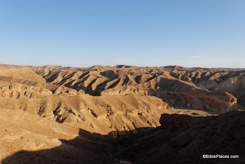
This week’s photo comes from Volume 5 of the revised and expanded edition of the Pictorial Library of Bible Lands and is entitled “Wilderness of Paran” (photo ID #: tb042007570).
The Wilderness of Paran is a desert region northwest of the Gulf of Aqaba that today straddles the southern end of the State of Israel and the eastern edge of Egypt. It appears in the Biblical text as a lonely place outside the Promised Land. This region is the place where Ishmael and Hagar lived after Abraham sent them away (Gen. 21:20-21). It is also a place where David sojourned to escape from Saul (1 Sam 25:1), and a place that Hadad the Edomite passed through while he and some other Edomites were fleeing from David and Joab (1 Kgs. 11:14-19). It is apparent from these passages that this region often served as a safe haven for people who were cast out or were fleeing from danger.
The Wilderness of Paran is also where Israel spent part of their time during the Wilderness Wanderings (Num. 10:12; 12:16). In fact, this is the fateful area where God’s judgment fell on the people. While they were encamped here, they sent the twelve spies into the land of Canaan and when ten of the spies brought back a bad report, the people rebelled against the Lord and refused to go into the land (Num. 13:2-3, 26). Consequently, that generation was doomed to die in the wilderness because they failed to trust in God and obey him. A photo such as this can enhance the retelling of that key chapter in Israel’s history.
This photo is included in Volume 5 of the Pictorial Library of Bible Lands and can be purchased here. More information about the Wilderness of Paran can be found on the BiblePlaces website here.
Today’s BiblePlaces Newsletter features a sale on everything we produce and a free collection of photos of Caesarea.