fbpx

(Guest post by A.D. Riddle)

In addition to taking a trip to Israel or attending a class, museums are another excellent way to learn about the world of the Bible, but sometimes you do not always know what to look for or how to connect it to the Bible.

Clyde Fant and Mitchell Reddish, noted before on this blog for their guidebook to biblical sites in Turkey and Greece, have produced a book (a few years ago) that will help with just that:

Clyde E. Fant and Mitchell G. Reddish, Lost Treasures of the Bible (Grand Rapids: Eerdmans, 2008).

The subtitle of the book is more informative: “Understanding the Bible through Archaeological Artifacts in World Museums.” The book’s contents are divided into eight sections that correspond to historical periods or to types of biblical literature.

Creation and Flood Stories
Israel’s Ancestral, Exodus, and Settlement Periods
The Period of the Monarchy
The Period of the Babylonian Exile
Poetry and Wisdom Literature
The Persian Period
The Hellenistic Period
The Roman Period

Two additional sections cover “Ancient Biblical Texts” and “Sensational Finds: Genuine or Forgery?”

The richest sections are “The Period of the Monarchy” and “The Roman Period.” Within these ten sections, the book contains 107 entries, with some entries covering a single museum object and other entries covering a group of related objects. Each entry is about four-five pages in length and nearly all of the entries include a black-and-white photograph of the museum object. Entries begin with a description of the object(s): dimensions, language (if inscribed), provenance, date, museum location and number. This is followed by a prose description of the discovery of the object and its historical context. The authors provide a satisfying amount of detail in this section and it seems to be well-researched. The final section for each entry discusses the “Biblical Significance” of the object. Some objects, of course, have a more direct biblical connection than others, but others will draw your attention to details of the Bible that maybe you have not noticed before. Where the biblical significance is (or has been) disputed by scholars, Fant and Reddish present the options in a fair-handed way. For example, it used to be argued that the creation account in Genesis directly depended on Mesopotamian creation accounts, but Fant and Reddish are careful to point out both the comparisons and the contrasts.

The book includes objects from about 30 museums in the U.S., Britain, Germany, France, Israel, Turkey, Greece, and elsewhere. The book is made even more useful by including a scripture index, an index of museum numbers, and an index of objects organized by museum. So, for example, say you are going to visit the Oriental Institute Museum in Chicago, you can look up the museum in the index and see a list of objects on display so that you have an idea of where you might want to concentrate your attention while you are there. Or, say you are studying Acts and want to show how Luke was quite accurate and precise in many of the details he gives, you can use the scripture index to look up relevant entries.

There are, of course, many more objects and other museums that could have been included, but Fant and Reddish give good coverage of the most important objects (and many less familiar ones) and the most important areas of connection with the Bible. I think you will be pleased and impressed with the level of detail and the quality of research.

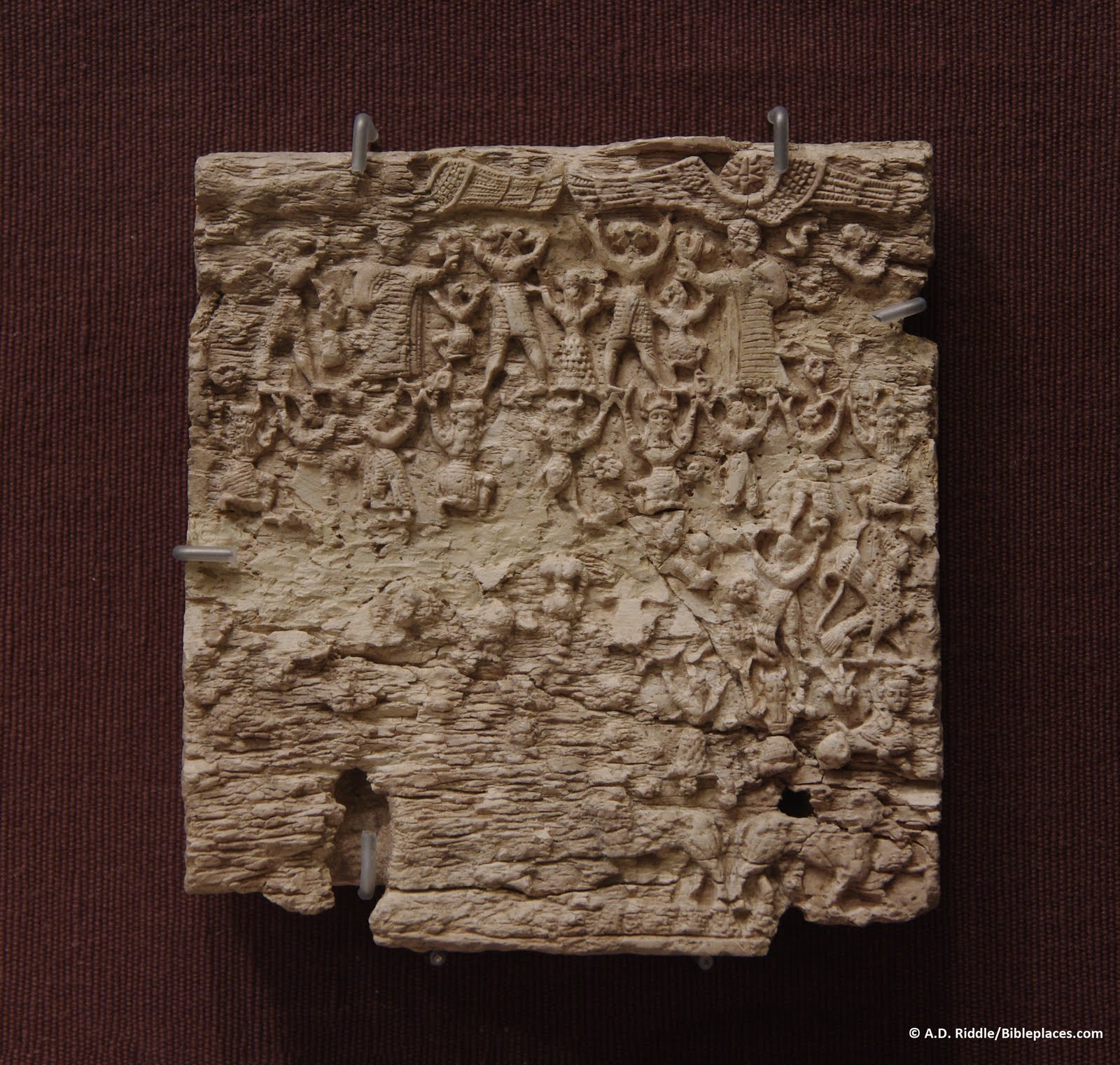
A Hittite plaque made of ivory from Late Bronze Megiddo,
Oriental Institute Museum, Chicago.
Not included in Lost Treasures of the Bible.
Share:

Question: I was wondering if you know of any websites that sell maps of Israel (4 x 3 feet or so) for decorative wall mounting? I found some information about Palestinian Exploration Fund linen maps selling for $200-400, dating back to 1800s but that’s about it. I prefer a vintage look over a modern National Geographic look. If you have any leads, could you pass them on? Thanks! –J.K.


Answer: I don’t know of anywhere to purchase printed maps like these, but perhaps you could find some high-res ones online that you could enlarge and print. Because any created before 1923 are no longer under copyright restriction (in the U.S.), many are available online. I would recommend that you begin with the following sources:

http://www.jnul.huji.ac.il/dl/maps/pal/html/

http://jewishhistory.huji.ac.il/links/maps.htm

http://www.lib.utexas.edu/maps/historical/index.html

Another possibility is the collection of Survey of Western Palestine maps that we produced. These are very high resolution on the CD (~7500×6500 pixels) and in my archive I have even higher-resolution images available by request.

Readers who have other suggestions are welcome to comment below.

Jerusalem center, SHEET_17

Survey of Western Palestine (1880), a section of Sheet 17
Share:

Yesterday I gave the arguments for the view that includes Transjordan within the Promised Land.

This was the position of the other two faculty when I was teaching in Israel. I held to the opposing view, namely that the Jordan River is the eastern border of the “Promised Land.” Biblical evidence in support of this position includes the following:

1. The land promised to Abraham, Isaac, and Jacob was “Canaan.” “The whole land of Canaan, where you are now an alien, I will give as an everlasting possession to you and your descendants after you” (Gen 17:8; cf. Exod 6:4; Lev 14:34). Countless passages make it clear that the land aspect of the promise included only Canaan. The biblical or extrabiblical descriptions of Canaan never include territory east of the Jordan River.

2. In preparation for the conquest, God said that the eastern border of the land they were to inherit would run from “the Sea of Kinnereth…down along the Jordan and end at the Salt Sea” (Num 34:11-12).

Wadi in Gilead mountains, tb110603119

The mountains of Gilead

3. Moses was forbidden from entering the promised land; consequently he stood on Mount Nebo (which had already been given to the tribe of Reuben) to “view Canaan, the land I am giving the Israelites as their own possession” (Deut. 32:49).

4. If the land of the Amorites in Transjordan was part of what God had originally determined to give
the Israelites, Moses would not have bothered sending a request for safe passage through the territory of Sihon the Amorite. In any dealings with the “promised land,” Moses and Joshua simply destroyed the population without making any requests of them (e.g., Jericho, Ai, Hazor). It was only because Sihon refused to allow Israel to pass (perhaps thinking that the Israelites would leave him alone as they had done previously with the Edomites, Moabites and Ammonites) that the Israelites destroyed his army and their cities. As a result, the land was available for settlement and the two and a half tribes came to Moses with this special request.

5. After the Conquest, the two and a half Transjordanian tribes reported back to Joshua in order to receive permission to return to their land. Joshua said that this was “the land that Moses gave you on the other side of the Jordan,” explaining that it was legitimate for them to live there, but that it was not part of the original land of promise (Josh 22:4). Joshua also said that this land was “acquired in accordance with the command of the Lord” (Josh. 22:8), also indicating that such a notice was necessary because this was not part of Canaan granted to Abraham.

6. The construction of an altar by the two and a half tribes nearly resulted in a civil war. The Cisjordanian tribes accused their brethren of rebelling by building the altar near the Jordan River.

Note their statement: “If the land you possess is defiled, come over to the LORD’s land, where the LORD’s tabernacle stands, and share the land with us” (Josh 22:18). “The land” here clearly means “the land of promise.” The Transjordanian tribes respond that they built it only to prevent a future division between the tribes: “We did it for fear that some day your descendants might say to ours, ‘What do you have to do with the LORD, the God of Israel? The LORD has made the Jordan a boundary between us and you—you Reubenites and Gadites! You have no share in the LORD.’ So your descendants might cause ours to stop fearing the LORD” (Josh 22:24-25). God indeed had made the Jordan a boundary, not only a natural one, but one that defined the borders of the promised land and one that potentially threatened the nation’s unity.

7. In a period still future (best understood as applying to the earthly millennial kingdom), God will divide the land among the twelve tribes (Ezek 47:13-23). It will be divided equally among the tribes, with Joseph receiving two portions. “This land will become your inheritance.” The border is clearly demarcated on the eastern side of the Jordan River. “On the east side the boundary will run…along the Jordan between Gilead and the land of Israel, to the eastern sea” (Ezek 47:18).

Concluding Thought:

The issue is not whether or not it was legitimate for the two and a half tribes to settle in Transjordan.

Clearly this was granted by God. The question is whether or not this land was considered part of the everlasting “promise.” If the Transjordanian territory falls within the definition of “inherited” but not “promised” land, it may best be understood as the temporary but not eternal possession of the Israelites.

Share:

When I taught in Israel, the faculty was split on the question of whether the Promised Land includes territory on the east side of the Jordan River or not. None of us questioned whether or not God had promised to give the land of Canaan on the west side of the Jordan River to Abraham and his descendants, but we could not agree on whether the land given to Reuben, Gad, and half of Manasseh should be considered to be in the Promised Land or not.

Today I will present the affirmative side of the debate. Those who believe in a literal fulfillment of Old Testament prophecies will recognize the potential ramifications of this issue.

1. The “land of the Amorites” was included in the original promise (Gen 15:21), and Sihon, king of the Amorites, lived in Transjordan (Josh 12:6).

2. There are specific statements by God that the land inhabited by the Amorite kings in Transjordan would be given to Israel (cf. also Deut 2:12, 24; 3:2, 18).

  • Deut 2:31. “The Lord said to me, ‘Behold, I have begun to give Sihon and his land over to you; begin to take possession, that you may occupy his land.’”
  • Psalm 136:19-22. “…who slew famous kings…Sihon…and Og…and gave their land as a heritage… to Israel His servant.”

3. By the command of God, cities of refuge and Levitical cities were established east of the Jordan (Num 35; Josh 20, 21). Ten of the forty-eight Levitical cites were in Transjordan. The Levitical cities are on both sides of the Jordan in accordance with divine proscription, impossible if Transjordan territory is not included in the inheritance of Israel.

4. Numbers 34, which designates the Jordan River as the eastern boundary, in context, must specifically refer to the land that yet remained unconquered in Cisjordan. Note especially Numbers 34:2, 13-15. In this passage Moses clearly states that Reuben, Gad and half of Manasseh already have their inheritance east of the Jordan. The remaining territory, the Land of Canaan, west of the Jordan, was yet to be divided up by lot to the other nine and a half tribes.

Jordan River at Yardenit, tb052908536

The Jordan River

5. Israel could expand the promise to the point that more cities could be added (Deut 19:8-10).

6. The land that Moses “gave” on the other side was “acquired in accordance with the command of the Lord” (Josh 22:4-5, 9).

7. Manasseh’s “inheritance” is east of the Jordan. This is the same term used for the other tribes (Josh 13:8ff; cf. Judg 11:23-24).

8. A prophecy of the end times speaks of Israel’s presence in Transjordan: The Israelites “will lay hands on Edom and Moab and the Ammonites will be subject to them” (Isa 11:14; cf. Ezek 25:4-14).

The eminent geographer Barry Beitzel is one who holds a view similar to that presented here (The New Moody Atlas of the Bible, 26-29). Tomorrow I will present the arguments for my view.

Share:

Question: I read in a commentary the claim that the Dead Sea is visible from the top of the Mount of Olives. When I was there we didn’t go all the way to the top. Is this true? –K.P.


Answer: On most days you would not be able to answer this question because the air is so hazy. On a rare clear day, you would have this view just up the slope from Bethphage, with a sliver of the Dead Sea visible below the horizon.

Bethphage from Mount of Olives showing wilderness, mat02531

View of the Dead Sea from the Mount of Olives (photo source)
Share:

(Guest post by A.D. Riddle.)

At Urartian sites in northeast Anatolia, archaeologists have discovered geometric “rock signs” that were cut into bedrock. Some 134 signs have been found at 20 different sites (fortresses, canals, graves) in modern Turkey, Armenia, and Iran. The signs are circular, “U”-shaped, “V”-shaped, or sickle-shaped, and they are dated to the 8th and 7th centuries B.C. Regardless of location, the signs are all very similar in shape and dimensions to one another, with the signs from the later period being slightly smaller than the earlier ones.

Belli 2001: 365, fig. 2

Belli 2001: 367, fig. 7

It was originally thought the rock signs were used for grape presses, but this has been ruled out. Other ideas included quarries, hieroglyphs, or some religious function, but the conclusion is “there are no definite answers for now” (Belli 2001: 368).

In 2006, Erkan Konyar suggested that the rock signs were molds for shaping wooden chariot parts, and perhaps other wooden implements. (A pdf of his essay can be downloaded here.) He was able to identify the same component parts in depictions of chariots in Urartian and Assyrian reliefs, and the rock signs appear to correspond in shape and dimension to wheels, axle-braces, spokes, yokes, and hooks.

If he is correct, the “V”-shaped signs would have been molds for braces, spokes, and/or yokes.

Belli 2001: 367, fig. 8

The dimensions of the “V”-shaped signs are fairly close to the dimensions given for the “V” marks in the City of David (see here and here). The City of David marks are 5 cm deep and the Urartian rock signs are 4-10 cm deep. The City of David marks are 50 cm in length, and the Urartian “V” rock signs vary between 60 and 70 cm in length.

So, could the City of David marks be molds for shaping wooden implements? The wood would have to be softened in water first, and the marks appear to be conveniently located near Jerusalem’s water source. It would be irresponsible to suggest anything further at this point since we still have not heard many of the details about the marks from the City of David’s excavators, but the similarities with Urartian signs and the interpretation of them by Konyar are intriguing.

REFERENCES

Belli, Oktay.

2001 “Surveys of Monumental Urartian Rock Signs in East Anatolia.” Pp. 365-369 in İstanbul University’s Contributions to Archaeology in Turkey (1932-2000). Ed. O. Belli. Istanbul: İstanbul University Rectorate Research Fund.

Konyar, Erkan.

2006 “An Ethno-Archaeological Approach to the ‘Monumental Rock Signs’ in Eastern Anatolia.”
Colloquium Anatolicum 5: 113-126.

Share: