fbpx

Brian Janeway has just posted a review of last year’s ASOR meetings in an article entitled “Biblical Archaeology in 2010: Going Strong Still!”  If you missed the meetings or just would like a review, start here.

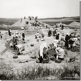
Eight papers were given on Khirbet Qeiyafa, the 10th century site next to the Elah Valley.

Khirbet Qeiyafa is the only known fortified city in Judah dated to the time span from the end of the 11th century to the beginning of the 10th century BC. The excavated pottery places the site in Iron IIA period and includes finger-stamped jar handles, ‘pre-LMLK’ jars, and late Philistine decorated pottery known as ‘Ashdod Ware.’ Petrographic analysis shows that the Philistine vessels were not made locally and were probably imported to the site. Dr. Aren Maeir, director of the excavations at nearby Tel es-Safi/Gath confirmed during the response period that the pottery assemblage was definitely not Philistine. Interesting comments were also offered by Bill Dever and John Holladay, both of whom compared the Qeiyafa pottery assemblage to Gezer 8 below the Solomonic Gate and Jane Cahill believes it parallels material found in Jerusalem above the stepped-stone structure at a time that coincides with an expansion of the city. Ron Tappy spoke about a new early 10th century phase found at Tell Zayit that predates the famous abecedary inscription.

The Elah Valley was the scene of the battle of David and Goliath, and this was the subject of another paper:

Another interesting presentation was given by Jeffrey Zorn of Cornell University entitled “Reconsidering Goliath: An Iron I Philistine Maryannu.” In it he revises the idea that Goliath was an infantry soldier through a textual analysis of his weaponry and accoutrements. Zorn asserts that the fish scale body armor, probably attached to an underlying tunic, bronze greaves, which are only found in Mycenaean Greek contexts c. 1200 BC, and his being accompanied by a shield-bearer, all point toward Goliath being a maryannu. Maryannu is a Hurrian term for an elite warrior who fought on chariots, usually alongside two attendants, as attested in Egyptian depictions at Medinet Habu of 3-man Egyptian and Hittite teams fighting at the Battle of Kadesh (c. 1275 BC).

Janeway reviews other presentations, but I’ll excerpt only one more.

“Hebrew  Bible, History, and Archaeology” featured papers by Anson Rainey, who made the case for identifying biblical Ziklag at Tell Sera’, based on biblical and medieval texts and Jeffrey Hudon of Andrews University, who proposed that the now famous LMLK storage jar seals had a longer period of production and use that originated during the reign of King Uzziah in the late 8th century and not to the later Hezekiah. The circumstances in 2 Chron 26:9-10 in its description of royal estates and viticulture occur in the same regions as the stamps have been found. They served as important royal symbols of the Judahite kingdom. These estates were established all across the kingdom from ‘En Gedi to the Shephelah and were the functional explanation for the LMLK stamps according to another paper by Hayah Katz of The Open University of Israel.

The full article is here.

Share:

Jerusalem’s Festival of Light ends this week.  Arutz-7 reports:

Traveling from all over the country to witness the artistic display, Israelis enjoyed strolling in and around the ancient walled Old City June 10-16, viewing light displays which were, for the most part, free of charge.  For a fee, visitors could enjoy the opening ceremony — The Light Concert in Sultan’s Pool — opposite the Old City walls and thousands did so. The Jerusalem Symphony Orchestra played light classical music while lights beamed towards the sky in time to it bounced back from the clouds.  The players were bathed in myriad colors of shimmering lights. The program began with an orchestrated medley of songs of Jerusalem and included a surprise–simultaneous fireworks and beams of light  during the playing of Tschaikovsky’s 1812 Overture. . Flautist Noam Buchman played "From the top of Mount Scopus" as the finale.

See the article for a dozen photos.

Share:

The Vatican will not be taking control of the Upper Room (Room of Last Supper, Coenaculum) according to this report in Arutz-7:

Israel National News has learned that the Last Supper Room is off the negotiating table, at least for now, in talks between Israel and the Vatican orchestrated by Deputy Foreign Minister Danny Ayalon.
[…]
One of the most difficult points of contention between Israel and the Vatican is the question of who controls the Last Supper Room. The room is said to mark the burial site of Kings Solomon and Hezekiah, and is also located in the same structure that houses the tomb of King David. Further complicating the matter is the fact that the building is known as the oldest Catholic church in the world, and has also served as a synagogue and as a mosque — in fact, Muslim inscriptions can still be seen on its walls. To simplify matters, the Last Supper Room was taken out of the agreement. “We basically reached the principle that it will not be part of this agreement,” the source said. “We have wanted the status quo, and they have wanted sovereignty,” since negotiations began 11 years ago. “At this point, it will not be discussed as part of this agreement, which is progress.”
Progress was also apparently made on the issue of Israel’s right to expropriate land when necessary, albeit not without some caveats. The status quo was maintained on most of the 21 disputed properties in the Land of Israel, but there were six outstanding exceptions in which Israel has allegedly agreed not to confiscate land “unless there is an extreme need”: the Mount of Beatitudes, Tabha, Capernaum, the Church of the Annunciation, Mt. Tabor and the Garden of Gethsemane. “Obviously if there is a security situation, the State of Israel can expropriate, as is the sovereign right of any nation,” the source said. “After 11 years, that’s real progress,” he said.

The full story is here.

Upper Room interior, tb070807001

Traditional Upper Room, Jerusalem
Share:

For the last twenty years I have used and recommended Carl G. Rasmussen’s Zondervan NIV Atlas of the Bible (1989). This week the revised edition (now entitled, Zondervan Atlas of the Bible) was released and my appreciation for it has only grown. In short, I highly recommend this atlas for everyone from church-goers to Israel tour participants to college and seminary students. Here are a few reasons why I am so enthusiastic:


First-person knowledge of the land: The author has not only led dozens of study trips to Israel, Turkey, and Greece, he has lived in Israel for many years. His intimate knowledge and love of therasmussen_atlas land and Scripture is reflected throughout the book.


Appreciation for geographical regions: Unfortunately it is unusual for an atlas to survey the distinct geographical units, but this atlas provides helpful summaries of the primary characteristics of the twenty major regions, such as the Jezreel Valley, Hill Country of Benjamin, Dead Sea, and Edom. If this is essential for you in an atlas, this is the one to get.


Historical survey from Genesis 3 to Revelation 3: The author begins in the Garden of Eden and ends with the churches of Revelation. That means that whatever event you want to know more about, you’ll find it here. More important than the broad scope is the accurate, knowledgeable treatment of the stories and issues.


Accurate, colorful maps: This atlas has more than a hundred full-color maps. There is a map on nearly every other page. I could wish for a few more detailed maps (e.g., Isaiah 10:28-32), but I’m certainly not disappointed with the quality or appearance.


Conservative convictions: This means a lot to me, and I was encouraged again and again to see that the author holds to time-tested views consistent with the biblical witness. That includes an early date for the patriarchs, an early date for the conquest, a willingness to allow that some of the Habiru may have been Israelites, and a high regard for the biblical descriptions of the reigns of David and Solomon.


Sound judgment: This, of course, is shorthand for “agrees with my conclusions,” but I was pleased to see, for example, that he suggests that Joshua’s Ai is “probably” Khirbet el-Maqatir, ignores the recent proposal that locates Sodom at Tell el-Hammam, and does not equate Kh. Qeiyafa with Shaaraim.


The end of the book: There are some terrific resources here, including the section on the disciplines of historical geography, Jerusalem, and the fantastic geographical dictionary and index.


Cost: $26 (Amazon). 


What could be better? Some might not like the small font, which I assume is necessary because of the profusion of maps, timelines, and photos. I regret that the endnotes were removed in this edition, and students who want to pursue issues he brings up will not find any help here. I wish he had written more about (and come to different conclusions on) some New Testament issues, such as the locations of Emmaus, the baptism of Jesus, Bethsaida, and the Gadara/Gerasa issue. Some resources should have been updated, such as Context of Scripture instead of the 1969 edition of ANET.  In my opinion, publishers should avoid using a photo of a non-biblical site (Petra) on the cover of a Bible atlas.

Overall, I highly recommend this new edition and I would certainly commend it for use in preparatory work before traveling to the Holy Lands as well as for college and graduate courses on Bible geography.

Share:

The latest LandMinds program features Wheaton professor Daniel Master concerning his excavations of Ashkelon.  This year they are focusing on periods before and after the Philistine occupation.

Another recent LandMinds program interviews Amnon Ben-Tor, excavator of Hazor.  The second part of the show features the directors of the survey and excavation team of Tel Burna (Bornat), possible biblical Libnah.

Over on PaleoBabble, Michael Heiser has announced a new online institute in which you can study the Bible, the ancient languages, ancient history, and more for a very low price. 

In Jeremiah 32, the Lord tells the prophet to purchase a plot of land even though the Babylonians are about to conquer the city.  If you want to see how archaeological background can help us to understand the details of a biblical story, check out Gordon Franz’s “archaeological exposition” of the passage.

360Cities has some beautiful panoramas from Egypt, including the Pyramids in Giza and the Karnak Temple in Luxor.

If you haven’t had a chance to walk through the sewers of ancient Jerusalem, Ferrell Jenkins is guiding tours today.

Share:

A month ago, I noted an excavation in the northern Hinnom Valley of Jerusalem that was investigated and photographed by Tom Powers.  The architecture was partly obscured in those photographs by tarps. 

Reader Roi Brit passed the area a few days ago and noted that the excavation appears to have stopped and the tarps have been removed.  Craig Dunning has sent some photographs he took this morning.

mamilla-dig-20100611-05

View of excavations, looking north

mamilla-dig-20100611-03

View of excavations, looking south.  The artisans’ quarter is visible in the background. 

mamilla-dig-20100611-02

Close-up of excavations

Jerusalem aerial from sw, tb010703209

Jerusalem from southwest.  Area of excavations is circled in red.

If anyone knows more about what we’re looking at, let us know.

Share: