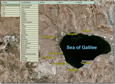
There’s a new interactive satellite map available for download. B. G. Galbraith created this using a high-resolution satellite photo of Israel and then identifying major biblical sites. Each site is hyper-linked to a page with photos, descriptions, and relevant Scriptures about it. The program is free and may be downloaded here. This is another great tool to learn about the land and the Bible. 
I commented previously on a horribly one-sided Haaretz article (or here) on Israeli archaeology in the West Bank. Professor Amnon Ben-Tor, an esteemed archaeologist at Hebrew University, has written a letter in response. This was published in the Haaretz Hebrew edition, but there are no plans to publish it in the English edition. The letter is posted here, but letters to the editor are not archived and will be removed soon. Thanks to Joseph Lauer for passing this on.
Ha’aretz [Hebrew]
December 29, 2006
יום שישי ח’ בטבת תשס”ז
כתם ארכיאולוגי
בתגובה על “ת”פ אלוף מרכז” מאת מירון רפופורט (“הארץ”, 15.12
בתגובה על “ת”פ אלוף מרכז” מאת מירון רפופורט (“הארץ”, 15.12
מירון רפופורט, המצטט את הארכיאולוג רפי גרינברג, כותב מפיו: “מאז 1967 נסקרו כ-5,000 אתרים ארכיאולוגיים בגדה… ארכיאולוגים ישראלים הם שניהלו את הסקרים, והם העדיפו, כמובן, לסקור אתרים החשובים להיסטוריה היהודית ולא להיסטוריה הפלשתינית… הארכיאולוגים הישראלים חיפשו בעיקר את בית ראשון או בית שני… אך טבעי הוא שארכיאולוגים יתעניינו בהיסטוריה של העם שלהם, ככה זה בכל העולם”.
האמירות האלה של גרינברג אינן מבוססות. כל כוונתו של סקר היא לקבוע את המפה היישובית באזור הנסקר בכל תקופה ותקופה, ולכן אין כל אפשרות להעדיף תקופה אחת על רעותה. כל המעיין בנתוני הסקרים העיקריים שנערכו בגדה לאחר 1967 על ידי זרטל, פינקלשטיין ועופר, יראה מיד שמספרם של האתרים שאינם “יהודיים” שנסקרו) כנעניים, ביזנטיים, מוסלמיים) גדול בהרבה מאלה ה”יהודיים”.
אשר לאתרים שנחפרו – גם כאן התמונה דומה: מאז שנת 2000 הוצאו רישיונות חפירה בגדה המערבית ל-147 אתרים, מהם ניתן להגדיר 14 כ”יהודיים” (20%), מספר קטן של אתרים כנעניים, ואילו הרוב המכריע הוא אתרים מהתקופה הביזנטית והמוסלמית.
דברים אלו נכונים גם לחקר האתרים שבתחומי הקו הירוק: האתרים שבהם נערכות חפירות בקנה מידה גדול בשנים האחרונות ובהם עכו, קיסריה, בית שאן, סוסיתא, בית גוברין, מרישה – אף לא אחד מאלו ניתן להגדיר כאתר “יהודי”. בשנת 2006 הוציאה רשות העתיקות 281 רישיונות חפירה: בכ-100 מאלו נחקרו מתקנים חקלאיים שאת “זהותם האתנית” של המשתמשים בהם לא ניתן לקבוע. בין יתר האתרים, כ-60 הם אתרים בני התקופה המוסלמית, 45-50 הם אתרים נוצריים, 35-40 הם אתרים בני התקופות הכנענית והפרהיסטורית ו-25 (פחות מ-10%) הם אתרים שבהם נחשפו שרידים מימי בית ראשון ושני. נתונים אלה כוללים גם את החפירות בירושלים.
את כל הנתונים הללו קיבלתי מקצין המטה לארכיאולוגיה ומרשות העתיקות בתוך פחות מ-12 שעות מאז פנייתי.
טענות מסוג אלה שטוען גרינברג נשמעות כמעט בכל כנס בינלאומי וכן בפרסומים “מדעיים”, ולצערנו התרגלנו כבר לסילופים אלו שכל כוונתם היא לתקוף את ישראל. גרינברג הכתים לא רק את עצמו, אלא את הארכיאולוגיה הישראלית בכללה. מה חבל, שבדומה לאלו שאינם ישראלים, נתן גם גרינברג להשקפתו הפוליטית לסלף את העובדות.
אמנון בן תור
ירושלים
ירושלים
*******************************
The following is an English translation of Dr. Amnon Ben-Tor’s Letter to the Editor published in Ha’aretz [Hebrew] on December 29, 2006. It was translated and is circulated with Dr. Ben-Tor’s permission, and also corrects a numerical typographical error made by the paper.
The letter was written in response to an article published in the Ha’aretz Hebrew Language Edition on December 15, 2006. The article was also published in the December 17, 2006 Ha’aretz English Language Edition under the caption “Buried treasure that’s kept in the dark”. The article is based on claims made by Dr. Rafi Greenberg regarding Israeli archaeology and archaeologists. As is evident from his letter, Dr. Ben-Tor takes strong exception to those claims.
*********************
An Archaeological Stain
In response to “Under Command of the GOC Central Command” by Meron Rapoport (Ha’aretz [December 15, 2006]).
Meron Rapoport, who quotes the archaeologist Rafi Greenberg, writes that he says that “Since 1967, some 5,000 archaeological sites in the West Bank have been surveyed…. the surveys were done by Israeli archaeologists and they naturally preferred sites that are important to Jewish rather than Palestinian history…. Israeli archaeologists have excavated mainly the First Temple and Second Temple periods…. It is natural for Israeli archaeologists to take an interest in the history of their people, … it’s the same everywhere.”
These statements of Greenberg are baseless. The whole purpose of a survey is to determine the map of settlement in the surveyed area in every period, and therefore there is no possibility of preferring one period over another. Anyone who studies the data from the main surveys that were conducted in the West Bank after 1967 by Zertal, Finkelstein and Ofer, will immediately see that the number of the surveyed sites that are not “Jewish” (Canaanite, Byzantine and Muslim) greatly exceed those that are “Jewish”.
The picture is similar with regard to the sites that were excavated. Since the year 2000, excavation permits were issued in the West Bank for 147 sites. Of them, 20 can be classified as “Jewish” (14%), and a small number as Canaanite sites, whereas the vast majority are sites from the Byzantine and Muslim periods.
These facts are also applicable to the examination of sites within the Green Line. Of the sites at which excavations were conducted on a large scale, including Acco, Caesarea, Bet Shean, Sussita, Bet Guvrin, Maresha, not even one could be characterized as a “Jewish” site. In 2006 the Israel Antiquities Authority issued 281 excavation permits: in about 100 of these agricultural installations were studied, about which the “ethnic identity” of their users could not be determined. Of the remaining sites, about 60 are Muslim-period sites, 45-50 are Christian sites, 35-40 are from Canaanite and pre-historic periods, and 25 (less than 10%) are sites at which First and Second Temple period remains were discovered. These data also include the excavations in Jerusalem.
I obtained all of these data from the staff officer for archaeology and from the Antiquities Authority in less than 12 hours from when I approached them.
Allegations of the type made by Greenberg are heard at almost every international conference and also in “scientific” publications, and to our regret we have already become accustomed to these distortions which are only intended to bash Israel. Greenberg did not only stain himself but Israel archaeology in general. What a pity that, like those who are not Israeli, Greenberg too has permitted his political opinions to distort the facts.
Amnon Ben-Tor
Jerusalem
Jerusalem
- Tagged Analysis
BiblePlaces readers may be interested in signing up for the Contextual Reflections newsletter published regularly by Preserving Bible Times (producer of the Above Israel DVD set). These Reflections are rooted in a strong knowledge of biblical geography and history and are thought-provoking as well. I cited the December issue in the discussion of “No Room in the Inn” and have frequently found the insights to be beneficial and challenging.
The signup sheet is rather intimidating, but you can check what you want. The signup sheet may lead you to believe that you’re in for frequent mailings and sales pitches, but I have found neither to be true. As a subscriber, I get good, helpful content about biblical matters. I recommend it.
Here’s a remarkable home-made video of a flash flood in the Negev of Israel. The cameraman and his companions don’t strike me as very smart, and the footage is shaky, but you’ll get the idea.
“Restore our fortunes, O Lord, like streams in the Negev” (Ps 126:4).
The problem with studying the geography of Israel is that it can quickly become divorced from the life-changing truths of Scripture. After all, how do hills and valleys help you grow closer to God?
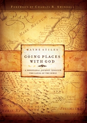
Wayne Stiles has the answer to that in his new book, Going Places With God: A Devotional Journey Through the Lands of the Bible. I am often asked what is the perfect follow-up to a trip to Israel. My typical answer (“read a Bible atlas”) just got better: read and meditate on the truths of this devotional guide. What makes this book so good is that it takes “boring” details of Scripture and shows how they are profitable for life and godliness.
Here’s an example: Stiles shows how the geography of Joseph’s brothers tending their sheep brought Joseph to slavery in Egypt and ultimately Israel’s deliverance from famine. Unless you understand the geography, you won’t fully appreciate God’s sovereignty. The author draws from that just how we should relate to our sometimes bewildering circumstances. In another story, Israel has to travel all the way around Edom, and Stiles explains that in God’s plan, sometimes the long way is the best way.
I love too the way that Stiles draws beautiful word pictures. With him as guide, I picture myself one day walking along the shores of the Sea of Galilee and another day watching the sunrise from the Mount of Olives. A pastor for fourteen years, Stiles is a truly gifted communicator with a knowledge of where people are hurting today. One devotional will encourage you to increase your
trust in the all-powerful God, and another devotional will challenge you to take heed lest you fall.
Familiar lessons some, but brought to life from places in the Bible that you would never otherwise look.
I love the geographical nuggets contained in this book, but the reason that I am recommending it is this: Going Places With God will challenge you to live a radical, Christ-centered life. The book came
out a week ago: I encourage you to buy it, read it, and buy a couple for friends.
You can see more about the book and its author at this website. The book lists for $15, but Amazon has it for $10.
[Update: The free copies have all been claimed.]
- Tagged Resources
From a notice received today from the City of David visitor’s center:
Here are some very important updates for all travel agents, tour guides and trip organizers.
City of David Presentation – from 1.01.07, there will be a charge of NIS 5 per person for entry to the new 3-D presentation at the City of David. You can book a presentation together with a visit to the City of David, for preset times (only by making a definite booking, approved by the booking system). Due to the high demand, cancellation fees will be according to the price of the presentation itself (NIS 5), and the cancellation fees will be charged for any cancellation made within one week of the visit.
Set daily guided tours – please note – we offer daily tours accompanied by a guard (registration in advance, available to individuals). There is a set tour in Hebrew, and a set tour in English, starting daily at 10 a.m. (duration of guided tour about 3 hours).
The Shiloah Pool (Pool of Siloam) and Herodian Street – as of 1.01.07, this site (from the Second Temple era) will become a closed site of the Nature and Parks Authority. All visitors to the City of David will, of course, continue to enjoy this impressive site. The ticket to the City of David will continue to include entry to the Shiloah Pool. Visitors who only want to visit the Shiloah Pool will be able to purchase a ticket at the entrance to the pool, at the foot of the City of David, near the Kidron ravine. Entry fee to the Shiloah Pool and Herodian Street will be NIS 6 per person.
The City of David “Segway” – special trips in an up-to-the-minute, ingeniously designed two-wheeled vehicle. The tour lasts about an hour and a half, along the Armon HaNatziv (Commissioner’s Palace) pr omenades – the eastern Goldman Promenade, the Sherover Promenade, and the Haas Promenade. An impressive and scenic tour, accompanied by an official tour guide, with breathtaking views and an “action” ride in the state-of-the-art vehicle. NIS 150 per person for the trip!
Temporary closure of the Shiloah Tunnel (Hezekiah’s Tunnel) for routine
maintenance – between 14.01.07 and 28.01.07, the Shiloah Tunnel will be closed for two weeks for ongoing maintenance work and restoration of the plaster on the floor of the tunnel.
We will be happy to help you with any clarifications and inquiries –
City of David Booking Center – *6033
At your service
Sincerely
Shahar Shilo
Marketing director, City of David
- Tagged Jerusalem
Search
About the BiblePlaces Blog
The BiblePlaces Blog provides updates and analysis of the latest in biblical archaeology, history, and geography. Unless otherwise noted, the posts are written by Todd Bolen, PhD, Professor of Biblical Studies at The Master’s University.
Subscribe
Tags
10th Century
American Colony Photos
Analysis
Antiquities Trade
Dead Sea
Dead Sea Scrolls
Discoveries
Egypt
Excavations
Forgery
Galilee
Greece
Holidays
Israel's Coast
Italy
Jerusalem
Jezreel Valley
Jordan
Jordan Rift
Judah
Lebanon
Lectures
Mediterranean Islands
Mesopotamia
Museums
Negev
New Exhibits
Persia
Philistines
Photo Resources
Picture of the Week
Pseudo-Archaeology
Resources
Sad News
Samaria
Shephelah
Syria
Technology
Temple Mount
Tomb of Jesus
Tourism
Travels
Turkey
Weather
Weekend Roundup
Links
Notice
As an Amazon Associate we earn from qualifying purchases. In any case, we will provide honest advice.