fbpx

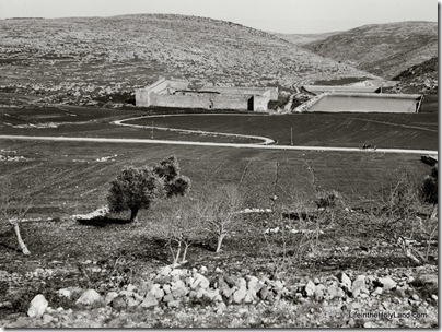
We’re not sure who built the enormous water reservoirs three miles south of Bethlehem, but there’s no evidence that they are related to their namesake.  It is most likely that King Herod or one of his successors built these pools to supply Jerusalem with water.  A complex and sophisticated series of aqueducts was constructed both to feed these three pools as well as to transport the water from here to multiple locations in Jerusalem. 

The water system naturally required repair over the years, but it continued in use, off and on, through the British Mandate period.  One evidence of the significance of these pools is the presence of a fortress built by Suleiman the Magnificent in the 16th century.  (Yes, this is the same ruler who built the walls around the Old City of Jerusalem and constructed the fortress still standing at Aphek-Antipatris.)

The photo below was taken by the American Colony photographers in the early 1900s.

Solomon's Pools from west, mat07571Solomon’s Pools, view from west, early 1900s 

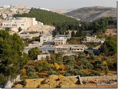
Today the area has changed dramatically, making it difficult even to locate Suleiman’s fortress.  Other attempts that I have made to photograph the three pools have been thwarted by the forest that has been planted in the area.

Solomon's Pools area from west, tb112406464 Solomon’s Pools, view from west, 2006

The top photograph is from the newly published Southern Palestine volume of The American Colony and Eric Matson Collection (originally Library of Congress, LC-matpc-07571).  The CD includes more than 550 high-resolution photographs from the Dead Sea, Jordan River, Jericho, Judean hill country, Shephelah, and Negev.
Share:

I think that for a certain subset of this blog’s readers, photo challenges are enjoyable.  I’ll tell you a little and you can tell me the rest.  This photo is part of the Jerusalem volume of The American Colony and Eric Matson Collection and it was taken in approximately 1900.

jerusalem_challenge

The best answer in the comments below wins a free copy of the Jerusalem CD (or your choice of another if you already have it).  An important part of the answer is why it is impossible to take this same photo today.

Share:

Recently a friend alerted me to a discussion online about major renovations to be started soon in the vicinity of Jaffa Gate.  Among other things, this will close the gate off to vehicular traffic.  If they dig anything up, chances are very high that they’ll find something of significance, which will slow their progress down even further.  A source in Jerusalem relates the following:

1. The gate is being closed to car traffic due to road renovations.

2. They may leave one lane open for one-way traffic.

3. The gate is supposed to close soon after Succot (which ended a few days ago).

4. A Muslim policeman “who isn’t trustworthy” said that the gate would NOT reopen ever.

5. Shop owners are concerned about how they will receive supplies.

This is not the first time the authorities have done major work on the road here.

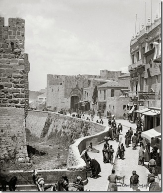
View inside Jaffa Gate, mat04928 Jaffa Gate area from east, with Crusader moat of Citadel visible in foreground.  Date of photograph: 1898-1907.  From the new Jerusalem CD.
Share:

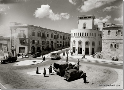
The photo below shows another very familiar place in Jerusalem, at the northwestern corner of the Old City walls.  This site, I believe, may be distinguished as the location most often renovated in the modern city’s history.  I’ve long suspected that the municipality, which has its offices on the north side of this square, uses the area as training grounds for its construction crews.

New City outside nw corner of Old City walls, mat13390

This American Colony photo shows how the area looked sometime between 1932 and 1946.  The round building on the right served as Barclay’s Bank on the lower floor and basement, while the rest of the building held offices of the City Hall.  Because it was located next to “No Man’s Land” from 1948 to 1967, the building’s facade today bears pockmarks from the hostilities.  Mayor Teddy Kollek’s office was in the second floor of this building for many years.

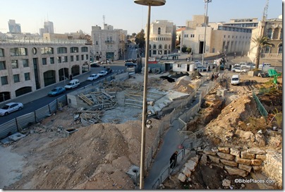
011Construction at Old City northwest corner, tb122006010dxo2

This picture could have been taken many times since, as the area has been torn up time and again to install various traffic features, water fountains, and pedestrian walkways.  This photo was taken in December 2006 after the construction of a traffic tunnel.  The round building is in the distant center.

Excavations near Old City northwest corner, Peter Wong, IMG_6480

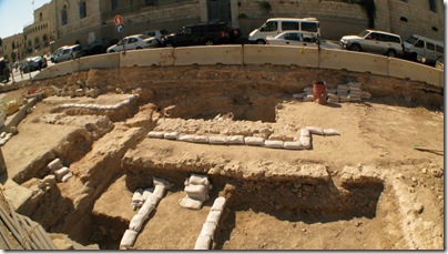
This photo was taken in July 2009 by Peter Wong and looks west (the municipal building is off to the right).  It shows excavations of the area, including what appears to be a cistern in the top center.

Shortly after Peter took this photo, the area was cemented over.

Share:

Jewish Quarter from Temple Mount, mat04722

Jewish Quarter from the Temple Mount

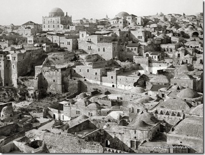
It wasn’t all that long ago that this area looked very different.  This photograph, taken from the Temple Mount, looks towards the Jewish Quarter.  I don’t have a “today” comparison because sensitivities now do not allow one to access this area.

Dominating the skyline are two domed synagogues, once major landmarks in the Old City: the taller Tiferet Israel (“Glory of Israel”) on the left and the Hurvah (“Ruin”) on the right. Sadly, both structures fell victim to the hostilities of 1948. During the final fighting for the Jewish Quarter in May 1948, both synagogues, which had served as strategic positions for the quarter’s Jewish defenders, were intentionally blown up by Arab forces. Then, with Israeli control of the Old City after 1967, the remains of both buildings were consolidated and preserved as memorials. Until 2006, the Hurvah site sported a memorial arch which became a visual symbol of the new Jewish Quarter and an Old City landmark. Today the Hurvah is being rebuilt, exactly to its original mid-19th century appearance.

In the foreground are the houses and other structures of the Mughrabi Quarter, an Arab neighborhood which covered what is now the expansive Western Wall plaza and the adjacent excavated areas around the Temple Mount. After Israel captured the Old City in the 1967 Six Day War, within a matter of days the Mughrabi Quarter’s residents were forced out and relocated, and most of the buildings seen here were razed. However, the lower floors of some of the houses became the base of an earthen ramp that provided access to the Temple Mount’s Mughrabi Gate from 1967 until 2004, when part of the ramp collapsed. Now, these same houses—and more ancient structures beneath them—are being exposed archaeologically in advance of construction of a new Mughrabi Gate foot-bridge.42_jerusalem_front

This photograph and description are taken from the Jerusalem volume of The American Colony and Eric Matson Collection.  The photograph is originally from the Library of Congress, LC-matpc-04722, and the description was written by Tom Powers.  The $25 CD includes 685 high-resolution photographs and the equivalent of a 200-page book of annotations such as the one above.

Share:

Understanding the ancient Pool(s) of Siloam is a bit difficult.  First, there is the pool where Hezekiah’s Tunnel emerges.  This pool is small, shallow, and unimpressive.  In 2004, a monumental reservoir was discovered to the south, dating to the 1st century A.D. (for more on that, see here and here).

Scholars today do not yet know how the two pools are related.  The Lower Pool was quite likely the place of the miracle of the healing of the blind man (John 9).  The area above was the site of a pool in the Late Roman period, and continued in use in the Byzantine period when a 5th century church was constructed over it.  What existed here before the destruction of Jerusalem in A.D. 70 is not known.

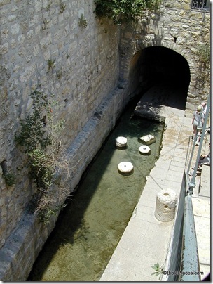
Pool of Siloam, tb051501204

Pool of Siloam, view to the north, present day

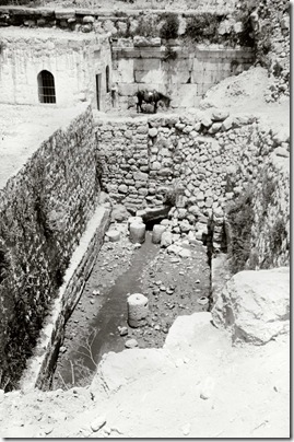
Today if you visit the pool at the end of Hezekiah’s Tunnel, there are a few column drums from the Byzantine pool, but little else to suggest the beautiful complex that pilgrims visited.  That hasn’t always been the case, however, for the excavations of Bliss and Dickie in the 1890s revealed some of the ancient walls.  In the photo below, behind the donkey is a wall of large, well-dressed stones with a classical molding.  The excavators identified this as the northern side of the square Roman pool.

Pool of Siloam, north end, mat08471 Pool of Siloam, view to the north, early 1900s

After the excavations, Muslims erected a mosque over the northwestern corner of the area, covering all traces of the earlier pool and the Byzantine church built to commemorate it. 

This photograph is one of 45 in the “City of David” set included in the Jerusalem volume of The American Colony and Eric Matson Collection.  Photo: Library of Congress, LC-matpc-08471.

Share: