fbpx

I’ve often been asked how tells grew so tall.  True, winds in the Middle East blow lots of dust throughout the year, but that certainly cannot account for tells which are 80 feet high.  A.D. Riddle recently sent me the following quotation from C. Leonard Woolley, in which he gives a good explanation for the phenomenon of tells from his report on excavations at Carchemish.  I have placed in bold the answer to this question, but the whole is worth reading, despite its length.  Woolley writes:

The whole of North Syria is dotted with tells, artificial mounds which consist of and conceal old settlements. So little has been done in the way of excavating these mounds that it is dangerous to theorize too much about the nature of what lies beneath them; but certain features which are common to all, or which distinguish one from another, may, with such more sure information as digging has afforded, serve to throw light on the conditions of life which brought them into being and shaped their history.

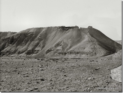
Tell el-Farah South, general view, mat13993 Tell el-Farah South

The neolithic folk, the original founders, undoubtedly, of all these tells, built their huts of mud and rubble either on some slight knoll or, where none such lay to hand, on an artificial platform laboriously piled up with basketful after basketful of earth,—piled just high enough to raise them above the damp of the level soil. The huts fell in ruins, and these ruins raised the ground level on which new homes were built, and that at a goodly rate, for mud-brick walls tend to be thick, and their cubic contents are very great in proportion to the area they enclose, and as the bricks can scarcely be used a second time the whole material of the fallen house was let lie where it fell and was merely leveled for the foundations of the new. Year after year went on this accumulation of débris and of house rubbish (there are sites in the Near East where the rubbish-heaps outside the walls are nearly as extensive as and much higher than the ruins themselves), and the original platform reached a height at which it commanded all the surrounding country. Then a wealthier generation, perhaps more warlike, or more timorous, walled the hill-top round, turning their village in to a stronghold. The chance of an asylum would attract new-comers, whose houses huddled together on the slopes of the mound and spread over the low ground at its foot, and this in its turn began to heap itself up above the level of the plain around. After a while the outsiders, too, might demand protection for their homes, not content to leave them in war-time to the mercy of the enemy while themselves taking refuge in the fort: they built a wall round the new outer town. In proportion as the whole town was thus made defensible, the original settlement, the tell, tended to become less a place of general residence, more and more the centre of administration and of worship; here the princeling might live in isolated state, here were the barracks of his regular retinue, here the temples which from of old had been the houses of gods or heroes deified. At the same time the defences of the tell were kept in good repair, for whatever might be its use of every day, it was still the inner stronghold, the last resort in case the rest should fall; from a military point of view the outer town and its high citadel within might be compared to the mediaeval castle with its bailey and its keep.

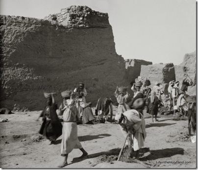
Tell el-Farah South, excavation, mat13986 Excavation of Tell el-Farah South, 1928-29, directed by Sir W. M. F. Petrie

Of course tells differ one from another in form as they differed in their history. There are low mounds scarcely noticeable above the level of the plain, short-lived villages whose ruins, scanty at their best, may have grown even less distinct through the gradual raising of the ground about them-the natural effect of long cultivation and often too of the ploughing of the nearer hillsides, whence little by little the rain carries the loosened surface soil down to the valleys. There are small steep-sided cones which, one thinks, can hardly be other than keeps or watchtowers, not the outgrowth of village settlements but military foundations to secure frontiers or trade-routes. There are rather larger whale-backed mounds, higher and more abrupt at one end and tailing off fanwise at the other, where one can almost see the cluster of domed or flat-roofed single-storied mud huts with, at the outskirts, the effendi’s two-storied house of stone dominating them from its higher ground. Again, on a larger scale, we have the steep-sided C-shaped tell with a broad channel running down it at a gentler slope between the horns of the letter, like a volcano’s crater with a gap in the rim; it looks as if, on the older mound’s flat top, a huge ring wall had been built with a gateway and an approach thereto between flanking towers. In other cases the main tell is more or less pyramidal in form with, on one side, the lower rounded mound of the outer town, its flimsier walls indistinguishable now from the heaped mass of house ruins which they enclose: in a few, the outer walls stand out clearly as a ring of earthworks overtopped only by the great bulk of the acropolis within.

Source: Woolley, C. Leonard. 1921. Carchemish: Report on the Excavations at Jerablus on behalf of the British Museum, Part 2: The Town Defences. London: Trustees of the British Museum.

The two photographs are from the newly published Southern Palestine volume of The American Colony and Eric Matson Collection (originally Library of Congress, LC-matpc-13993 and LC-matpc-13986).
Share:

There’s a recent article on Khirbet Qeiyafa that is relevant for anyone interested in the discussion concerning the site’s identity as Shaaraim (for a primer on Qeiyafa, go here) or in archaeological methodology. Since the article’s thesis is that the survey results contradict the excavation results, it is significant that the author is Yehudah Dagan, director of the Judean Shephelah Survey Project which began in 1977.

The article is entitled “Khirbet Qeiyafa in the Judean Shephelah: Some Considerations” and it was published this year in Tel Aviv, volume 36, pages 68-81. If you or your institution has a subscription to Ingenta, you can access it online (or pay $39).

This is the article’s abstract:

The excavations at Khirbet Qeiyafa have attracted attention recently following the discovery of a city gate and the proposals of the excavators that it be dated to the 10th century BCE and identified with biblical Sha’arayim. Based on my survey of the site, I suggest an alternative settlement history and a different interpretation of the construction stages of the circumference wall. I also propose an alternative identification of the biblical city of Sha’arayim.

In short, Dagan’s conclusions concerning the settlement of the site are nearly the opposite of what the excavators have reported.  Dagan found pottery from Early Bronze, Middle Bronze, and Iron I, but the excavators apparently found nothing significant from these periods.  The chief period of occupation according to the excavators is Iron IIa (roughly the time of King David), and Dagan says he found nothing from this period!  The excavators then say the site was abandoned until the Hellenistic period, but Dagan says that the majority of potsherds from the site are from the Iron IIb-c period.  Dagan also found material from Roman, Byzantine, Early Islamic, Mamluk, and Ottoman periods, about which little has been said by the archaeologists (to my recollection). 


Survey


Excavation
Early Bronze Yes No
Middle Bronze Yes No
Iron I Yes No
Iron IIa No Chief period
Iron IIb-c Majority Nothing
Hellenistic Yes Yes
Roman Yes ?
Byzantine Yes ?
Early Islamic Yes ?
Mamluk Yes ?
Ottoman Yes ?

Any way you approach it, what we have here are startlingly different conclusions from survey results versus excavation work.  It is one thing to find material from one or two periods which were not represented in a survey (which is limited to potsherds found on the surface).  But this is almost a complete mismatch, making one wonder if they are studying the same site.

To say it a different way, it’s less significant that Dagan did not find any Iron IIa material in his survey than it is that Garfinkel has found no Iron IIb-c material.  Sites are not always evenly settled (or preserved) and archaeologists often find a period of occupation missing in one area of the tell. 

But Iron IIa was relatively short-lived (less than 100 years) and Iron IIb-c lasted several centuries (c. 930-586).  Dagan claims that the majority of the potsherds he collected was from this period, and that’s not surprising given the large population of the Shephelah during the Divided Monarchy.  What is quite unusual, and the cause of much discussion last year, was Garfinkel’s conclusion that this was a single-period site in Iron IIa.  He said that it was settled, quickly fortified, and then abandoned within a generation.

The point here isn’t to resolve the debate, but merely to note its existence.  It certainly is a lesson in the need for excavation, and not a reliance upon survey alone.  However, if Dagan’s survey has merit, the discrepancies with the present excavation results require some explanation.  An example of the severity of the disagreement concerns the famous Iron Age gate, which Dagan says may actually be Hellenistic!  He writes,

Hellenistic finds were discerned in the passage and all the chambers of the gate, and a floor with Hellenistic pottery was exposed in the southeastern chamber of the gate, resting on bedrock (Garfinkel and Ganor 2008c: 128–129). Four-chambered gates are not alien to the Hellenistic period (e.g., Mount Gerizim) (page 76).

Another lesson from this matter: interpretations are only as good as the data they are based on.  If Dagan is right (and I don’t know that he is), all of the discussion about identifying the site as Shaaraim, Ephes-dammim, or other may be misguided. 

Stay tuned.  No doubt Garfinkel has some new data from his 2009 excavations and this article has undoubtedly lit some fires.  Perhaps it is not irrelevant that Dagan conducted his survey under the auspices of Tel Aviv University and Garfinkel is a professor at the Hebrew University of Jerusalem. 

(As far back as Yadin and Aharoni, if one said black, the other said white.)  We look forward to clarification.

Share:

Gordon Franz has a new article posted in the “Cracked Pot Archaeology” category of his Life and Land blog.  His entry entitled “Yahweh Inscription Discovered at Mount Sinai” is an analysis of recent claims by Robert Cornuke concerning an inscribed stone allegedly found near Jebel al-Lawz in Saudi Arabia.  Franz includes drawings of the inscription, a link to a video with Cornuke’s presentation, and a careful rebuttal of the reading and authenticity of the inscription.

I won’t repeat Franz’s analysis here, but will only make the observation that there will always be a market for the sorts of things that Cornuke and others like him are selling.  Why?  Some people (rightly) believe the Bible is a trustworthy historical source.  Some people (rightly) believe that scholarship and media are biased against their views.  Some people (wrongly) conclude that anything that scholarship and the media dismiss is trustworthy.  This leaves a wide open door for charlatans, hucksters, as well as well-meaning but ignorant individuals.  The key to success lies not in knowledge of the subject but in an ability to communicate.

I’ve commented previously on Cornuke’s claims here and here.

Share:

Every time a story surfaces on the internet that is obviously (in my mind) bogus, I prefer to ignore it here.  But after receiving several emails from sharp individuals, I think this one must be worthy of comment.  Instead of just stating that the story about Egyptian coins from Joseph’s time should be ignored, I’ll suggest a few clues that should make you suspicious. 

1) The report claims to prove the biblical account.  I believe the Bible is an accurate historical account, but experience has taught me that most news reports claiming such are untrustworthy. 

2) The discovery was reported by an Egyptian newspaper.  This is not the place where credible scholars break stories. 

3) Coins were not invented until approximately 600 BC.  By anyone’s reckoning, Joseph lived or did not live many hundreds of years earlier. 

4) A statement like this: “Some of the coins are from the time when Joseph lived in Egypt.”  There is no time (singular) when scholars believed Joseph lived. 

There are various theories about when he lived.  No credible source would make this statement without a discussion of when the “coins” date to and how we now know when Joseph lived. 

5) Statements from the Quran about Joseph were used by the archaeologist as credible historical testimony.

6) If it sounds too good to be true…: “Among these, there was one coin that had an inscription on it, and an image of a cow symbolizing Pharaoh’s dream about the seven fat cows and seven lean cows, and the seven green stalks of grain and seven dry stalks of grain.”  7) Never in the report is a date or the name of a pharaoh given!

The story was re-reported as fact by the Jerusalem Post and Arutz-7 (shame on them; their editors must be off for the Yom Kippur weekend).  The only one I’ve seen refuting this so far is Paleojudaica and Joe Lauer, who rightly questions whether this was released on the Egyptian version of April Fool’s Day.

UPDATE: Michael S. Heiser has several helpful comments on PaleoBabble.  I don’t think I was aware of this blog before, but some readers here will certainly want to follow what is dubbed as “your antidote to cyber-twaddle and misguided research about the ancient world.”

Share:

The Copper Scroll is certainly one of the most intriguing of the Dead Sea Scrolls.  The only text inscribed on two copper sheets, it lists the location of sixty treasures apparently in Judah in the period before the First Jewish Revolt in A.D. 70.  Many scholars believe that the list is authentic, but despite numerous efforts of the years no one has ever found any of the treasure.

The Jerusalem Post reports on an Oklahoma fire marshal named Jim Barfield who believes that he knows the location of not just one or two hiding places, but 56 of them.

After looking at the scroll for five minutes he deciphered the first location, and twenty minutes later he identified the next four locations. He and his wife took their first trip to Israel to confirm whether the sites and places that he had identified actually existed. “I wanted to make sure I wasn’t just imagining things,” Barfield said. It took six months for Barfield to crack the code for the rest of the locations.

This guy is pretty good.  He was able to figure out the locations without ever being to Israel, without knowing the language that the inscription is written in, and without having any background in archaeology or geography.

It’s nice to know what others think about his discovery:

He says that all of the archaeologists, rabbis, and historians presented with his research have been convinced. “It is so simple.” He says. “They just all thump their heads.”

Unfortunately, we only get it in Barfield’s words.

I don’t know enough to say that this guy is a fraud, only that he sounds like one.  If he actually has found something, he should go dig it out and then report on it.  But if he’s a publicity hound, I can write the script for the next few years: initial attempts will be stymied by various obstacles, during which time he’ll do many interviews and attempt to raise lots of money.  When he finally digs at one of his spots, he’ll find nothing – no treasure and no indication that any treasure was ever hidden there.  He’ll claim that it was stolen in antiquity (another round of interviews and appeals for cash) and start planning for a second excavation.  Efforts to dig will be hindered by various obstacles, during which time he’ll do many interviews and attempt to raise lots of money.  Etc.

The article itself is worth reading as it provides interesting and accurate information about the Copper Scroll.  You can find an introduction to and translation of the scroll in Florentino Garcia Martinez, The Dead Sea Scrolls Translated, 2nd ed., pages 459-63.  An excellent reference is the Encyclopedia of the Dead Sea Scrolls (2 volumes).

Share:

My friend A.D. Riddle sends along this interesting quotation from J. B. Pritchard, Recovering Sarepta, A Phoenician City: Excavations at Sarafand, Lebanon, 1969-1974 (1978):

The western face of the promontory had been eroded by heavy seas. In the scarp, stubs of walls and masses of Roman sherds could be seen, but nothing earlier. Scouring the surface of the fields on top of the mound for diagnostic sherds that might date its occupation, we found two handles from amphorae that had been imported from the Island of Rhodes. They could be dated to the Hellenistic period by the labels in Greek which had been stamped on them. Obviously the site had been occupied at least two centuries before the Roman port was built. Below the Hellenistic debris there might be the remains of an Iron Age settlement, but on the surface there was no evidence—not a single potsherd—to witness a Phoenician presence (p. 71).

In the excavations, Pritchard revealed seven layers preceding the Hellenistic period, including five from the Iron Age.

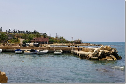
Zarephath Phoenician harbor & tell from E,ar090508617Zarephath (Sarepta) harbor and tell from east
Photo by A.D. Riddle, May 2009
Share: