fbpx

The Book and the Spade radio program just posted the first of two interviews with Qeiyafa excavator Yosef Garfinkel (the link there is updated every week for the current program).

National Geographic reports on the Qeiyafa excavation.  Much of the story reports what has been covered elsewhere, but there are some problems with the article.  (Does mentioning these help to prevent their perpetuation by journalists or others?)

The article begins:

The remains of an ancient gate has pinpointed the location of the biblical city Sha’arayim, say archaeologists working in Israel.
In the Bible, young King David is described as battling Goliath in the city, before eventually killing him in the Elah Valley.

Ahem.  Is it really that hard for the NG journalist (Mati Milstein) to open the Bible (1 Samuel 17) and read the story of David and Goliath?  The battle did not occur in a city, and Shaaraim is mentioned only as a point on a road that the Philistines used to flee.  It’s quite a creative re-telling that puts the battle in the city, but Goliath’s eventual death in the valley.  Even if the writer couldn’t find a Bible (or locate one on the Internet), couldn’t he have asked the archaeologist he was interviewing?  Since this is the entire reason why anyone cares about this excavation as opposed to the hundreds of others in Israel (and this is evidenced by its placement in the first two paragraphs), shouldn’t NG try to get at least this right?  If they can’t, can you trust anything in the article?

Later in the article, archaeologist Amos Kloner comments on the site identification:

“This is an initial idea, all aspects of which must be examined,” he said. “[But] it doesn’t matter if there is a second gate … This provides no indication of a Judean population there.”

Apparently Garfinkel hasn’t convinced everyone that the mere presence of a second gate absolutely and infallibly confirms that Qeiyafa is Shaaraim.  I think, however, that Kloner is wrong if he follows Garfinkel in the idea that Qeiyafa must be a Judean site in order to be Shaaraim.  In fact, as I argued before, I think a better case can be made from the only source that we have that at the time of the
battle, Shaaraim was in Philistine hands. 

The article closes with this quote from Garfinkel:

Garfinkel said he will continue to explore the Elah site in search of further evidence.
“Maybe we’ll find an inscription on the gate indicating who built the city: ‘I David, son of Yishai, built this city,'” he said with a laugh.

That’s a typical archaeologist kind of joke, and it wouldn’t be worth a response, except that Garfinkel has suggested elsewhere that he is serious about the possibility that David built the Qeiyafa fortress. 

I think it is entirely possible that David built the Qeiyafa fortress, but if he did, Qeiyafa is not Shaaraim.  You can have one, but not the other, unless you believe the biblical account is completely confused.  This is the big problem with those scholars who want to claim the “middle ground” between maximalists and minimalists: they claim validation for their results based upon data which they believe is faulty.  In other words, the scholar says, our evidence that Qeiyafa is Shaaraim is the biblical text which mentions this site (Shaaraim) in this area (Elah Valley).  The Bible says that Shaaraim existed before David became king.  We can believe the Bible that Shaaraim was a city in this area, but we can’t believe the same biblical story that Shaaraim existed before David.  This is very typical scholarly logic, but it is usually dressed up in fancy language, and supported by one questionable hypothesis built upon another dubious theory.

UPDATE (10 p.m.): The initial paragraphs of the NG article have been changed:

The remains of an ancient gate have pinpointed the location of the biblical city Sha’arayim, say archaeologists working in Israel.
In the Bible young David, a future king, is described as battling Goliath in the Elah Valley near Sha’arayim.

Share:

The San Francisco Chronicle is reporting that excavator Yosi Garfinkel believes Khirbet Qeiyafa is Shaaraim (Shaarayim), and this is confirmed by David Willner on the excavation website. This suggestion does not need to deny the David and Goliath story to find support (as does the Gob identification). Garfinkel will make a presentation (or two) this week about the site, but from what has been revealed thus far, there are two bases for his conclusion. 1) Shaaraim is mentioned in the story of David and Goliath (1 Sam 17:52). 2) Garfinkel found a second gate at the site last week. This is suggestive because the name “Shaaraim” means “two gates.”

This portion of the article is worth quoting:

Garfinkel, who has excavated numerous sites in Israel, says he discovered the second gate after noticing an apparent break in the massive stone wall as he walked along the 2,100-foot long structure that faced the road to Jerusalem. After two days of digging, his hunch paid off. A second entrance constructed from massive stones lay just a few feet beneath the topsoil.
“This is the only city from the Iron Age in this region ever found with two gates,” said Garfinkel as he clambered over the huge structure. “It was probably a mistake. It made the city more vulnerable. It might explain why it appears to have been settled only twice, for very short periods.”
Garfinkel says he is certain the newly-found massive stone gate was the main entrance to the city that existed at the beginning of the 10th century B.C. and then again for a few years at the time of Alexander the Great.
“It is enormous, it has symbolic value demonstrating authority and the power of the kingdom,” Garfinkel said while describing the huge building blocks of more than 3 feet square and 10 feet long, each weighing more than 10 tons. “They are the largest ever found from the Iron Age. If King David ever came here from Jerusalem, he entered from this gate. It is likely we are walking in the footsteps of King David.”

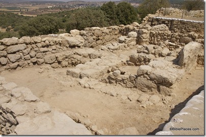
Khirbet Qeiyafa, 10th c casemate wall, ar080731445 Casemate wall at Khirbet Qeiyafa, 10th century B.C.

This is very significant, for not only are there very few early 10th-century fortifications in Israel, I don’t know of any with two gates. There are, however, some potential problems. 1) Apparently only a few days have been spent in excavation of this second gate, which would suggest that caution in conclusions at this point is wise. 2) Who built this massive gate? If it dates to the early 10th century, then one might connect it with David’s kingdom. But if that is so, then it was not the scene of his pre-kingship battle with Goliath. Perhaps, then, it was built by King Saul. The problem with that is that scholars don’t believe he had any real power. 3) Why were two gates built? Did someone who went to all the work in moving stones weighing more than 10 tons really not think through the problem of having two gates? I have trouble believing that we today understand their warfare better than they did.

There are some other potential problems with this identification. The only other place where Shaaraim is mentioned in the Bible is in a list of cities of Judah.

Joshua 15:33-36 (NASB) In the lowland: Eshtaol and Zorah and Ashnah, 34 and Zanoah and En-gannim, Tappuah and Enam, 35 Jarmuth and Adullam, Socoh and Azekah, 36 and Shaaraim and Adithaim and Gederah and Gederothaim; fourteen cities with their villages.

This text proceeds roughly from north to south (Sorek Valley, then Elah Valley). The sites in the Elah Valley appear to proceed from east to west: Adullam, Socoh, Azekah. If so, this suggests that Shaaraim would be located west of Azekah. If Shaaraim was Qeiyafa, it would logically fit between Socoh and Azekah.

This location (west of Azekah) seems to be supported by the David and Goliath account. Shaaraim is mentioned only at the end of the story. The Philistines fled west from the battle to Gath and Ekron, dying on the way of Shaaraim.

1 Samuel 17:52 (NASB) The men of Israel and Judah arose and shouted and pursued the Philistines as far as the valley [or Gath], and to the gates of Ekron. And the slain Philistines lay along the way to Shaaraim, even to Gath and Ekron.

Normally, this construction “way of [place]” means the road to a certain place (e.g., 1 Sam 13:17-18; 2 Sam 2:24; for a myriad of examples, see Dorsey, Roads and Highways of Ancient Israel, 47-50, where he finds only one road in the Bible not named after its destination, Num 20:17). It is difficult to conceive of a battle scenario where the road they are fleeing on would be called the “way of Shaaraim” if Shaaraim = Qeiyafa. 1) If the Philistines were encamped on the south side of the valley and the Israelites were encamped on the north side near Qeiyafa, why would the Philistines flee on the “way of Shaaraim”? 2) If the battle was much farther to the east, and the Israelites were encamped in the lower slopes of the hill country and the Philistines were encamped on the eastern end of the Elah Valley, a) one wonders why it was called the way of Shaaraim and not the way of Azekah, the bigger and more well-known city nearby and b) one cannot account for the Philistines being encamped “between Azekah and Socoh.” In short, Shaaraim is best located on the far (eastern, northern, or southern) side of Azekah, and not on the side closer to the battlefield. This also makes sense of the following phrase “the way of Shaaraim as far as Gath and Ekron.”

John Hobbins interacts with Garfinkel’s proposal of Shaaraim. I agree with him on point #1 but do not think he goes far enough (as I have above). I disagree on point #2, as it seems that if the Philistines are fleeing towards Shaaraim, then this would likely be in their territory. To say it another way, if Qeiyafa = Shaaraim, we should expect it to be a Philistine site (at least at the time of the battle). Garfinkel’s evidence suggests that Qeiyafa is an Israelite site.

This does not address the reality of “two gates” at Qeiyafa. If we are certain that both were in use at the same time, and we know that there are no other sites in the area that had two gates, this would be strong evidence. I don’t know how certain the excavators are that the two gates are contemporaneous.
I’m very hesitant to say that there are no other sites with two gates, since until a week ago, even Qeiyafa was not known to have two.

By way of conclusion: If Qeiyafa is Shaaraim, either 1) the Israelites were encamped here at the time of the battle of David and Goliath or 2) the Philistines were not encamped between Azekah and Socoh or 3) Shaaraim = Ephes-dammim. Of the three, I find #1 to be most likely, but it then is strange that a) Shaaraim is not mentioned as the place of Israel’s encampment and b) the Philistines are said to have fled on the way of this Israelite site. From the Philistine perspective, the road from Gath to the east might be called the “way of Shaaraim” (though it requires ignoring Azekah), but the biblical record was not written from the Philistine perspective.

Neither this post, nor the previous one, furthers my suggestion that Qeiyafa is Ephes-dammim. But they do, I believe, make the identifications with Gob and Shaaraim less attractive. Everyone in the discussion is working with a fraction of the total evidence. Garfinkel, as excavator, has more of the evidence available to him, but it is not difficult to imagine future discoveries that significantly clarify or alter the picture. To that end, we wish the excavators great success in their on-going work.

Share:

Nadav Na’aman has written an article (pdf) in the Journal of Hebrew Scriptures suggesting that Kh. Qeiyafa is Gob.  Na’aman begins with the conclusion that Qeiyafa is a Philistine site.  He does this by dismissing three lines of evidence from the excavators (pottery, absence of pig bones, Hebrew inscription).  I am unconvinced by this part of the discussion, but I don’t think it undermines the rest of his presentation.

The next paragraph is of most interest to me, as I previously suggested that Qeiyafa be identified with Ephes-dammim.  Let’s follow Na’aman’s line of reasoning.  It’s important to note that his cursory dismissal allows him to move to a more radical proposal.  His text is in bold and my comments are in brackets.

The description [of 1 Sam 17:1-2] indicates that the story was written after the consolidation of the kingdom of Judah, when Socoh (and Azekah) were Judahite cities. [He presupposes, contrary to the biblical account, that Judah was only formed many years after the time of David.] According to the description, the Philistines encamped south of the Elah Valley, where Ephes-dammim must be sought, and Saul and his army arrived from the northeast and encamped north of the valley. [Read 1 Sam 17:1-2 again.  It says nothing about the Philistines being “south.”  Perhaps it was (and I have believed for many years that it was), but it only says that Ephes-dammim is between Azekah and Socoh, and as my photos here show, Qeiyafa is both between the two sites and north of the Elah Valley.] Although the Israelite army encamped not far from Khirbet Qeiyafa, this important stronghold is not mentioned in the story. [Whoa, see how he did that?  He just jumped right over the possibility that Qeiyafa is Ephes-dammim, because it “must” be on the south side.] Evidently, the site was destroyed and deserted at the time when the story was written. [This is typical of Na’aman’s work: one possibility, however unlikely, becomes the foundation for another possibility, which then becomes certainty, and the foundation for a larger theory (see the rest of the article).  But if you pull out one card, the house comes falling down.  Since his creative theory developed in the rest of the article requires precluding Qeiyafa from being Ephes-dammim, he must not allow this very real possibility to detain him.]

Elah Valley and Azekah view nw from Socoh, tb021707830

View from Socoh looking west towards Azekah

Na’aman then proceeds to 2 Samuel 21:19, and he concludes that the David and Goliath story (1 Sam 17) is a later and much embellished (and distorted) retelling of the former.  He does not seem to recognize the following weaknesses with his theory: 1) the victors in the two stories have different names; 2) the fathers of the victors in the two stories have different names; 3) the location of the battles are given in each account, but there is no similarity between the two; 4) the context of the two battles in the larger biblical narrative is unrelated; 5) 1 Chronicles 20:5 gives a parallel account of 2 Sam 21:19. 

If you’re going to continue with Na’aman, you have to accept that 1) the highly detailed account of David vs. Goliath is pure fiction based upon a historic “kernel” that bore no relation to it; 2) the author of Samuel was ignorant (or unconcerned) that he was including the same “story” twice – both the kernel and the later embellishment. 

A better approach is to recognize the close similarities between 2 Sam 21:19 and 1 Chron 20:5 and acknowledge that these are the same story, but 1 Sam 17 is a different event.  There are textual difficulties in the two brief accounts, but you can’t explain David out of the Goliath story of 1 Sam 17 by scribal errors.  Instead you have to believe in deliberate deception and/or incredible ignorance. 

(Much of the scholarly approach to the OT is predicated on these two principles: most ancients were stupid, and the few brilliant ones were liars, albeit espousing the worship of a highly ethical God.)

I do not, however, think that a rejection of Na’aman’s proposals to this point necessarily disqualifies his identification of Qeiyafa as Gob.  2 Samuel 21:18-19 mention two battles with the Philistines, and since 1) Qeiyafa is a logical place of conflict between Israelites and Philistines and 2) Gob has not yet been identified, I think it is a plausible idea.  I just think that Na’aman has much less evidence to support it than he thinks he does.

John Hobbins has written a lengthy analysis of Na’aman’s article.  He makes some good points against the identification of Qeiyafa as a Philistine site.  One problem, as I see it, is that we should not assume that the situation was static in this period of Israel’s history.  Quite possibly, sites changed hands.  In fact, that seems to be what is at stake in the narrative of David and Goliath.  The Shephelah was the contestable ground in the 11th century (see also the story of Keilah in 1 Sam 23), and the goal was to expand one’s borders.  In other words, Qeiyafa may have been built as a Philistine fortress but later taken by the Israelites, or vice versa.

Hobbins then agrees with Na’aman’s proposal that Qeiyafa is Gob.  Since the whole thesis depends on 2 Sam 21:19 being accurately preserved and thus contradicting 1 Sam 17 and 1 Chron 20:5, Hobbins and Edgecomb discuss some more technical aspects of textual criticism of these verses in the comments section.  While I agree with Edgecomb on this, I would make this overall point: it’s not reassuring when a grand theory is built upon a difficult text against other easier texts. It is better to follow 1 Sam 17 than to undo it based upon tenuous theories and emendation of brief, problematic verses elsewhere.

Tomorrow I will respond to the proposal by archaeologist Yosi Garfinkel that Qeiyafa is Shaarayim.

Share:

Last week Eilat Mazar announced that she had discovered a water channel connected to the building she has identified as the palace of King David.  Based on the tunnel’s date, location, and characteristics, she believes that she has identified “with high probability” the shaft used by David’s men to conquer Jerusalem.  You may recall the story:

On that day, David said, “Anyone who conquers the Jebusites will have to use the tsinnor to reach those ‘lame and blind’ who are David’s enemies” (2 Samuel 5:8).

The Hebrew word tsinnor is usually translated “water shaft.”  For many years, this shaft was identified with a 40 foot (13 m) vertical shaft near the Gihon Spring.  More recent excavations have suggested that this shaft was not accessible during the time of David.

The story gets the press-release-rehash in the Jerusalem Post and Arutz-7The Trumpet, because of its close relationship with Mazar, has two photos.  Haaretz apparently wrote their story before the press release and has some strange information about the water system:

But Mazar believes the water system served to purify David’s warriors, first among them his chief of staff, Joab, after the city had already been conquered.

She says that purification was necessary because the Bible states they had to fight against the “blind and the lame,” and in so doing would have become impure. She notes the use in the relevant verse of the Hebrew root naga (touch) in relation to the “gutter,” a word usually involving matters of purity.

Here are just a few thoughts (based on the articles, not the minimal information above):

It seems that this channel was discovered at the end of the last season of excavation, and much more work is required.

Both ends of the tunnel are currently blocked, so it is not clear where the tunnel begins or ends.

The tunnel runs north-south, that is, roughly from the area of “David’s palace” towards the Temple Mount, all within the city fortifications.  This does not seem to fit the type of passageway that would be needed to conquer the city.

Oil lamps from the end of the First Temple period (c. 600 B.C.) were found, but it’s not clear how Mazar knows the tunnel was in use in the time of David.  It’s usually easier to date the end of use of a water system than the beginning.

The attempt to also connect the tunnel with refugees fleeing from Jerusalem in the days of King Zedekiah seems stretched.

Both identifications of the tunnel to the Bible (David and Zedekiah) strike me as the sort of “biblical archaeology” that Bible believers like myself wish would go away.  By that I mean, you find a tunnel and without knowing where it begins or where it ends, you assume that it must be the very one that is mentioned in a famous story in the Scriptures.  How is it that such archaeologists, working in a very restricted area, always happen to find exactly what they are looking for?

The solution is not to refuse to make connections to the Bible, nor to deny that the Biblical record is historically accurate, but instead to carefully study all of the evidence, avoiding unwarranted and premature sensationalistic headlines.  It goes both ways; more often it is scholars on the other side who use a scrap of evidence as complete and compelling proof that the biblical story is false.  Abuses on one side do not justify abuses on the other.

Share:

The New York Times has an article in tomorrow’s print edition about Khirbet Qeiyafa (with thanks to Joe Lauer for pointing it out).  The article appears to me to be a teaser, released on the same day of the excavator’s lecture in Jerusalem, which likely will include some new revelations.  The article quotes a number of archaeologists, but most of the information is already known to those who have followed the excavation here or elsewhere.  I’m going to comment on some portions of the article, but you’ll do best the read the article in its entirety first, and then read my comments.

Five lines on pottery uncovered here appear to be the oldest Hebrew text ever found and are likely to have a major impact on knowledge about the history of literacy and alphabet development.

This is a dramatic statement, but the rest of the article ignores the inscription.  The “competition” for the earliest Hebrew text would be the Izbet Sartah inscription (11th century), the Gezer Calendar (10th century), and the Tel Zayit Inscription (10th century).  Interestingly, all of these inscriptions are from the same general vicinity (the western foothills, aka Shephelah).

A great power [like that described of David and Solomon], they note, would have left traces of cities and activity, and been mentioned by those around it. Yet in this area nothing like that has turned up — at least until now.

Hold on here.  Gezer is only a few miles up the road, and the excavations there were pretty decisive that it was a well-fortified city in the time of Solomon.  This is an example of trying to make the site more important by denigrating the significance of others.

Another reason this site holds such promise is that it was in use for only a short period, perhaps 20 years, and then destroyed — Mr. Garfinkel speculates in a battle with the Philistines — and abandoned for centuries, sealing the finds in Pompeii-like uniformity.

This is very important.  The problem with other sites is that they may be used for a long period of time, making it difficult to distinguish exactly what was going on at an earlier point it is history.  For that reason, archaeologists love destructions.  Even better is a single period site with a relatively short-lived occupation.

“The fortification required 200,000 tons of stone and probably 10 years to build,” he said as he walked around the site one recent morning. “There were 500 people inside. This was the main road to Jerusalem, the key strategic site to protect the kingdom of Jerusalem. If they built a fortification here, it was a real kingdom, pointing to urban cities and a centralized authority in Judah in the 10th century B.C.”

These are some numbers that I had not seen before.  It does seem strange that a fortress that took 10 years to build would only be in use for 20 years.  Why was it not rebuilt?  Was it because it was captured by the Philistines?  Or was it because David’s kingdom was strong enough (and its border now further away) that this fortress was no longer necessary?

“This is an important site, one of the very few cases from the 10th century where you can see a settlement fortified in a style that is typical of later Israelite and Judean cities,” said Amihai Mazar, a professor of archaeology at Hebrew University. “The question is who fortified it, who lived in it, why it was abandoned and how it all relates to the reign of David and Solomon.”

Mazar certainly asks the key questions.  It’s important to remember that many of these things are interpretive, which means that an archaeologist can interpret the finds one way and another archaeologist can come to a different (even opposite) conclusion.  If only the stones could speak.

The Philistines had a huge city, Gath, some seven miles away, but pottery found there looks distinct from what Mr. Garfinkel has found here.

This suggests that Qeiyafa was an Israelite fort.  That’s a real question because the Shephelah at this time was contested by the Philistines and Israelites.

Seymour Gitin, an archaeologist and a director of the Albright Institute in Jerusalem, a private American institution, who has seen the finds, said: “The real value is that there was an urban center in the 10th century. You can extrapolate and say this helps support a kingdom, a united monarchy under David and Solomon. People will rightly use this material to support that.”

What Gitin is saying is that a fortress like this doesn’t come out of nowhere.  There must be some sort of strong organizing force (government) that financed and directed it.  This compound wasn’t built by three bored Israelites one Sunday afternoon.

“Some of us look at things in a very ethnocentric way — everything is Israelite or Judahite,” [Israel Finkelstein] said. “History is not like that. There were other entities playing a big role in the southern part of the country. And even if it belongs to Jerusalem, fine. So there is a late 10th-century fortified structure there. I don’t believe that any archaeologist can revolutionize our entire understanding of Judah and Jerusalem by a single site. It doesn’t work that way. This is a cumulative discipline.”

Whoops!  Look at how quickly Finkelstein re-dated the whole enterprise by approximately a century. 

Earlier in the article the fortress is dated to 1050-970 B.C.  Finkelstein makes it late 10th-century with a wave of his hand.  This is not accidental, as his recent publications are built upon the theory that the biblical history was written very late and is entirely unreliable.  Any discovery which suggests a strong central government in Judah in the 10th century is very inconvenient for his views.

He [Garfinkel] says with some 96 percent of this site still to be unearthed, a process likely to take 10 years, he hopes that more writing, more olive pits and more pottery will be uncovered, and add depth to what he believes is a revolutionary find.

Most critical in the whole discussion is this note of caution.  Too often absolute and sensational conclusions are made after the first discoveries.  We have time.  Any discoveries heralded now, of course, certainly makes recruiting slave labor volunteers much easier.

The New York Times does not have any photos of the site, but we do.  For more photos of the site in relation to the Elah Valley, and my speculation before the Times article or Garfinkel’s lecture, see this previous blog post.  The Times article does not mention the possibility that Khirbet Qeiyafa is Ephes Dammim.

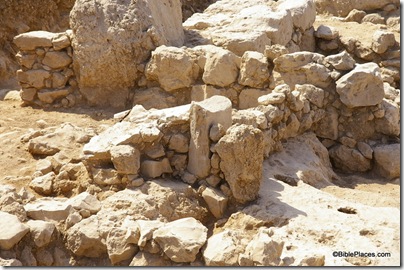
Khirbet Qeiyafa, 10th c four chambered gate, ar080731447

Khirbet Qeiyafa four-chambered gatehouse (10th century B.C.)
Khirbet Qeiyafa stele fragment, ar080731446  Khirbet Qeiyafa excavations with stele fragment
Share:

If I were teaching a course in historical geography now to advanced students, I’d cancel one of the assignments and have them write a paper on the site identification of Khirbet Qeiyafa.  They would be required to use all of the available data in suggesting possible candidates.  Since I’m not teaching such a class, I can post my own thoughts here without fear of hindering their research.

It’s been a few weeks since I wrote about Kh. Qeiyafa, so a brief review is in order:  Located next to the Elah Valley where David fought Goliath, Kh. Qeiyafa has been excavated the last two seasons (2007-08).  This summer a 10th century B.C. inscription (ostracon) was discovered (photo), the contents of which have not yet been revealed, but may be very interesting.

The place to start in identifying Kh. Qeiyafa with a known historical place name is to look at the general area of the site.  Kh. Qeiyafa is located on the north side of the Elah Valley, roughly north of probable Socoh (Kh. Abbad/Kh. es-Suweikeh) and east of probable Azekah (Tell Zakariyeh).  Those last two identifications are generally agreed upon by scholars, but as far as I know there’s no certain proof of either identification (for a good discussion of Socoh and Azekah, see The Sacred Bridge, page 147).  That’s important to keep in mind as we proceed under the assumption that Abbad = Socoh and Zakariyeh = Azekah.

Early explorers who identified sites like Hazor, Beth Shemesh, and Beth Shean did not have the advantage of aerial photographs and Google Earth.  But since we have those at our disposal, we will put them to use.

You can locate Qeiyafa on Google Earth using this kmz file.

You can locate Qeiyafa on Google Maps with this link (via G. M. Grena)

You can see the site in relation to Socoh (Abbad) and the Elah Valley on the photo below.
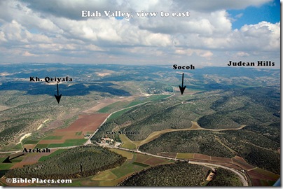
Elah Valley aerial from west, tb011606772_marked

Archaeology is critical in determining site identification, and Qeiyafa has remains dating to the early 10th century and to the Hellenistic period.  To do a thorough job in my little exercise, one would need to investigate Hellenistic sources concerning sites given in this area.  Because the occupation gap is so large (c. 800 years), it is possible that the Iron Age name was not preserved.  Since I am less knowledgeable about Hellenistic sources, and don’t have the necessary time, I am going to ignore this part of the equation.

The textual sources that we have for this time period are limited.  The Bible is the obvious place to start, though as I’ll note, some scholars question the traditional dates given to biblical texts.  Another source is the ostracon previously discussed.  It is possible that this ostracon has one or more place names and may single-handedly answer this question.  (Well, not really single-handedly, as it has to be in agreement with the rest of the data, but its relative importance is potentially great.)  Another possible source is Shishak’s conquest list as given on the Bubastite Portal in the Karnak Temple.

Since no other sites in the vicinity of the Elah Valley appear to be mentioned by Shishak, I am going to ignore that for now.

What can we learn from the Bible?  It might be instructive to note first that many scholars these days would sneer at this question.  It then would be worth reviewing just how many hundreds of accurate site identifications were made in the last 150 years, using the Bible as the primary source.  That is how Edward Robinson did it, as well as many successors on down to Yohanan Aharoni and his students and “grandstudents” (among whom I count myself).

A good place to start is with the passage of the battle of David and Goliath, as this was situated in the Elah Valley.  The setting is given in 1 Samuel 17:1:

Now the Philistines gathered their armies for battle. And they were gathered at Socoh, which belongs to Judah, and encamped between Socoh and Azekah, in Ephes-dammim (ESV).
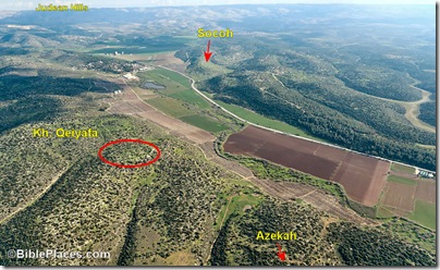
Elah Valley aerial from west, tb011606779b
Aerial view of Elah Valley, view to southeast

While the locations of Socoh and Azekah are generally agreed upon (see above), the location of Ephes-dammim is uncertain.  Based on the above text, it seems that it is located “between” the two sites.  “Pas Dammim” is mentioned in 1 Chronicles 11:13 and could well be the same place, though the event described there is a different one than the David and Goliath story.  A parallel to 1 Chron 11:13 is given in 2 Samuel 23:9; the place name is lacking in the Masoretic Text but is given as “Pas Dammim” in the Septuagint.  These are the only references to Ephes/Pas Dammim in the Bible.

In teaching the David and Goliath story, I’ve pointed to the “gas station” (labeled on the first photo above) as a possible place for Ephes-dammim.  There’s no evidence for this, but since no other site has been identified and this sits neatly between Azekah and Socoh on the southern ridge of the valley, it was a convenient marker.

But now a new possibility arises: Could Khirbet Qeiyafa be Ephes-dammim?  There are three points in favor of this identification:

1) Like Ephes-dammim (ED), Qeiyafa is “between” Azekah and Socoh;

2) Like ED, Qeiyafa was inhabited in the 10th century;

3) Since the only textual references to ED are in the 10th century, and Qeiyafa was inhabited only in the 10th century (during the time of the Bible), this too would match. [Note: the biblical chronology seems to put the David/Goliath battle in the late 11th century, but the difference is only a few decades here and archaeology is usually not able to be very precise, especially at this period of time.]
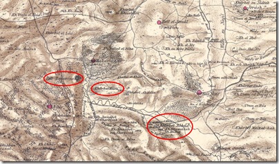
swpelah Kiafa (Qeiyafa) is clearly between Azekah and Socoh; map from Survey of Western Palestine (1870s)

Some have suggested that the modern site of Damun preserves the name of Ephes-dammim, but as Steven Ortiz notes in the Eerdman’s Dictionary of the Bible (p. 411), Damum is 4 miles (6.5 km) northeast of Socoh when one would expect it to be west (and east of Azekah).

Another possible text that lists cities from the 10th century (though many scholars think it dates to much later) is the list of Rehoboam’s fortifications (2 Chronicles 11:5-10): “Rehoboam lived in Jerusalem and built up towns for defense in Judah: Bethlehem, Etam, Tekoa, Beth Zur, Soco, Adullam, Gath, Mareshah, Ziph, Adoraim, Lachish, Azekah, Zorah, Aijalon and Hebron.”  The location of nearly all of these sites is pretty well agreed on, not suggesting another possibility for Qeiyafa.

A text that many scholars would go to for sites is the city list of Judah from Joshua 15.  Clearly this is the best geographical list for the area, but I didn’t start there because I believe (hold your breath) that this list dates hundreds of years earlier than the 10th century.  Most scholars do not, and accordingly, I will not ignore it. Joshua 15:33-36 lists cities of Judah: “In the western foothills: Eshtaol, Zorah, Ashnah, Zanoah, En Gannim, Tappuah, Enam, Jarmuth, Adullam, Socoh, Azekah, Shaaraim, Adithaim and Gederah (or Gederothaim)—fourteen towns and their villages.”  The location of many of these cities is not positively identified.  Based on the sites whose identification is generally agreed on (Eshtaol, Zorah, Jarmuth, Adullam, Socoh, Azekah), the list seems to proceed from north to south.  The Elah Valley sites are all known (Adullam, Socoh, Azekah), and do not give us an extra name to associate with Qeiyafa, particularly between Socoh and Azekah as we might expect from 1 Sam 17:1.  If Joshua 15 is a pre-10th century text, then this is not surprising.

The “prophet of the Shephelah” is Micah, who lived in the late 8th century.  His hometown is given as Moresheth (probably known elsewhere as Moresheth-gath) in Micah 1:1.  He pronounces judgment on many cities in the Shephelah from 1:10-16, a number of which are unknown (particularly in vv. 11-12).  Too little is stated to pin down locations for these (Beth Ophrah, Shaphir, Zaanan, Beth Ezel, Maroth), but none is mentioned in connection with Adullam, a city on the eastern end of the Elah valley.  Again, I wouldn’t expect to find a relevant name here since Qeiyafa was apparently abandoned several hundred years earlier.
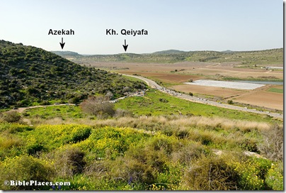
Elah Valley and Azekah view nw from Socoh, tb021707830 View from Socoh looking west towards Azekah

Are there other possibilities?  A quick check of Ahituv’s Canaanite Toponyms in Ancient Egyptian Documents, Tabula Imperii Romani, and Eusebius’s Onomasticon do not seem to suggest any other potential site names.

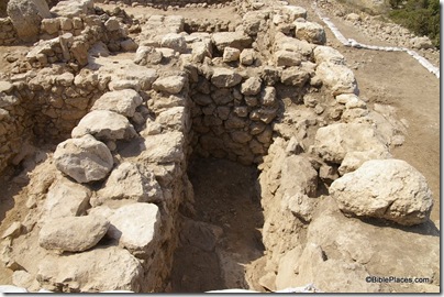
Was Kh. Qeiyafa a Philistine outpost?  This summer the excavations discovered a four-chambered
city gate and a 13-foot-wide (4 m) casemate wall. (Photos of excavations here and a 4-minute video of mostly still photos here.)  It certainly was a stronghold, and the only two known powers of the region at this time were the Philistines and the Israelites.  The Egyptians were back home enjoying their Third Intermediate Period, and there does not seem to be any strong contingent of Canaanites in the Shephelah (those would have likely migrated to where there were fewer enemies, such as the Jezreel Valley).

We can speculate further.  Perhaps Kh. Qeiyafa was Ephes-dammim, and it was constructed by the Israelites in the 11th century as they competed with Philistia for the Shephelah.  But one day the Philistines succeeded in capturing the fortress.  That brought Saul and the Israelites down to battle to regain their stronghold.  That could explain the otherwise curious reference in 1 Sam 17:1 to Ephes-dammim, as well as to giving its specific coordinates (since it was not well-known, then or later).

Unfortunately for the Israelites, Goliath wanted to make the battle a contest of champions and there was no one brave enough among the Israelites to respond.  The Israelites were encamped opposite the Philistines on the south side of the valley (which is the opposite of how I have always pictured it), or possibly in the hill country to the east.  David’s victory sent the Philistines fleeing towards Gath and Ekron (1 Sam 17:52), which makes perfect sense given the location of Kh. Qeiyafa.

While the above paragraph is speculative, the data that connects Qeiyafa with Ephes-dammim seems to me to be stronger than that which exists for many biblical sites.  The biblical text is very specific, and Qeiyafa matches exactly.  The dating of the fortress to the early 10th century is very close as well.  It’s certainly intriguing to consider.  Perhaps the ostracon discovered this summer will help to relate Kh. Qeiyafa to the biblical narrative, or even to confirm/deny the possibility that the site is biblical Ephes-dammim.  We’ll be interested to learn more when details are released.
Share: