fbpx

Wayne Stiles explores the 8 (present) and 12 (future) gates of Jerusalem.

Ferrell Jenkins shares some beautiful photos and helpful information about the Citadel of David in Jerusalem.

David Hansen provides an introduction to the significance of biblical geography that could be useful in many Bible classes. Note, in particular, the two important questions he suggests.

Jennifer Ristine, coordinator of the Visitors Center at Magdala, provides an explanation of the various symbols on the Magdala Stone.

Bryant Wood is on The Book and the Spade this week talking about “The Conquest and Archaeology.”

A 1500-year-old copy of the Ten Commandments is being auctioned off by the Living Torah Museum. There’s more here.

The Toledo Museum of Art is selling part of its Egyptian collection.

Five Dead Sea Scroll fragments have been put up for sale.

On November 15 in London, Sotheby’s is auctioning rare and early photo albums of the Holy Land,
including a rare hand-coloured subscriber’s copy of David Roberts’s Holy Land and Egypt.

HT: Joseph Lauer, Steven Anderson, Agade, Charles Savelle, Ted Weis, Paleojudaica

Share:

Forty-five shipwrecks, many dating back to ancient times, have been discovered off a Greek archipelago that is one of the Mediterranean’s richest underwater archaeological sites.”

A large and Roman mosaic has been discovered in Larnaca, Cyprus. A short video shows the excavation.

“A large number of expansive rock tombs which could constitute part of the world’s largest necropolis have been discovered during work carried out by the Şanlıurfa Municipality around the historic Urfa Castle in southeastern Turkey.”

“Excavation teams at an ancient site [Side] in the southern province of Antalya are struggling to find sponsors after it emerged that the site contains an ancient brothel.”

The Lion of Babylon is not faring well in part because of the visitors that keep climbing on its back.

The oldest writing found on papyrus is now on display in the Egyptian Museum in Cairo.

Scholars believe that have identified an ancient security system that protected the pharaoh’s burial chamber in one of the pyramids of Giza.

Philippi is in the latest group of sites to be named a UNESCO World Heritage site.

Some British MPs are proposing the return of the Elgin Marbles to smooth Britain’s departure from the EU.

Two Hellenistic marble sculptures from the Pergamon Museum in Berlin will remain on loan for the next two years at the New York Metropolitan Museum of Art.

The ancient Mamertine Prison in Rome will soon be open after three years for restoration and excavation.

After a $73 million renovation, Yale will soon be re-opening the Beinecke Rare Book & Manuscript Library.

“Dendrochronological and radiocarbon research by an international team led by Cornell archaeologist Sturt Manning has established an absolute timeline for the archaeological, historical and environmental record in Mesopotamia from the early second millennium B.C.”

Ben Witherington III has more than 20 posts on his recent trip to Turkey. Highlights include visits to the Miletus Museum, the Izmir Museum, and the Zeugma Museum (which has a splendid mosaic).

New book out from Eisenbrauns: “Did I Not Bring Israel Out of Egypt?” Biblical, Archaeological, and Egyptological Perspectives on the Exodus Narratives, edited by James K. Hoffmeier, Alan R. Millard, and Gary A. Rendsburg.

HT: Agade, Joseph Lauer, Ted Weis, Charles Savelle, Explorator, Daniel Wright

Share:
by Chris McKinny

Many visitors to Israel have visited the Nahal Zin and hiked into Ein Avdat. While witnessing the canyon’s spectacular views and wildlife, visitors will probably be informed that Nahal Zin was the southern border of the promised land (and thereby Canaan and the tribe of Judah) based on a connection between the large, continuous canyon (Arabic – Wadi el-Marra) and the southern boundary descriptions in the Bible (Num. 34:4; Josh. 15:3).
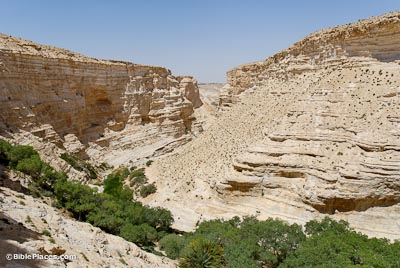
Ein Avdat – BiblePlaces.com

The identification of Wadi el-Marra with part of the Wilderness of Zin seems to be very plausible, even if the name “Nahal Zin” is a modern construction. Essentially, the identification of Wadi el-Marra with the southern boundary is based on the following two pieces of evidence: 1.) Wadi el-Marra is the only natural topographic boundary in the region and 2.) it is located between the Ascent of Akkrabim and Kadesh-barnea (Ein el-Qudeirat), which fits the biblical description. However, there is an additional piece of evidence that seems to make this identification even more secure – the location of Mount Halak at Jebel Halaq. Update – see here for Musil’s description of Jebel Halaq (German).

Southern Boundary Markers of Canaan/Judah on Karte Von Arabia Petraea (A. Musil 1906)

This identification was made over a century ago by Alois Musil in his Karte Von Arabia Petraea who was told that the northern cliff face of Wadi el-Marra (i.e. Nahal Zin) was called Jebel Halaq by the local population. Since “jebel” means “mountain” in Arabic and the second part of the name is identical to the biblical place name, this identification was generally accepted. However, since the early cartographic projects did not cover the Negev Highlands (e.g., the Survey of Western Palestine, Van De Velde’s Map) most are unaware of this connection and its implications for biblical geography. Mount Halak is mentioned twice in the book of Joshua, in both cases it is within a north-south boundary description describing the territory that Joshua conquered.

“So Joshua took all that land, the hill country and all the Negeb and all the land of Goshen and the lowland and the Arabah and the hill country of Israel and its lowland from Mount Halak, which rises toward Seir, as far as Baal-gad in the Valley of Lebanon below Mount Hermon. And he captured all their kings and struck them and put them to death. Joshua made war a long time with all those kings.” (Josh. 11:16–18 ESV) 

“And these are the kings of the land whom Joshua and the people of Israel defeated on the west side of the Jordan, from Baal-gad in the Valley of Lebanon to Mount Halak, that rises toward Seir” (Joshua 12:7 ESV)

Aerial view of Nahal Zin with view of Mount Halak (Jebel Halaq), photo by Bill Schlegel

Jebel Halaq faces towards southern Jordan and the mountains of Edom (i.e. Mt. Seir), which matches the passages from Joshua. When we add Mount Halak (Jebel Halaq) to the accepted identifications of Tamar (En-Hazeva), the Ascent of Akkrabim (Roman road west of Tamar rising to Mamshit), and Kadesh-barnea (Ein el-Qudeirat), it is clear that the various boundary descriptions were describing the same border, which they demarcated using various topographical features (oases, mountains, and natural roads). 

For those who visit the Nahal Zin/Ein Avdat, Mount Halak (Jebel Halaq) can be seen either on the bus ride down to the hike or at the Ben-Gurion tomb, which overlooks the Nahal Zin. Be sure to look that way next time you make it down there!
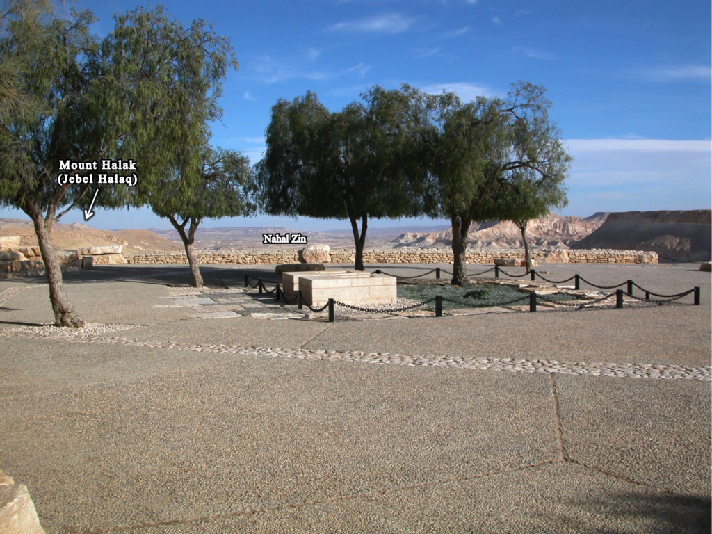
Ben-Gurion tombs with Nahal Zin and Mount Halak in background
Share:

A mikveh from the first century has been discovered in a southern Jerusalem neighborhood. This one was unusual because of the numerous wall paintings. Leen Ritmeyer comments here. You can access high-res photos here.

Excavations at Horvat Kur near the Sea of Galilee have exposed the mosaic floor of a Byzantine-era synagogue. For background and a map, see our previous post.

Nicholas Reeves believes that he has identified two unrecognized doorways in King Tut’s tomb, one of which leads to the undisturbed tomb of Nefertiti. The Economist gives a summary; Reeves’s published article may be read at academia.edu.

An exhibition with hundreds of Egyptian artifacts discovered underwater opens next month in Paris.

Lebanese authorities are working to halt the antiquities trade that passes through their country.

Babylon 3D has many beautiful reconstruction images of the ancient city.

The Museum of the Ara Pacis in Rome is hosting an exhibition on how the Roman Empire and its people ate.

Two suspects have been indicted on charges of setting fire to the Church of the Multiplication of
Loaves and Fish at Tabgha.

International Bible Study Week provided participants in Jerusalem with three days of lectures and one day of touring.

Thomas Levy announces the publication of papers from a 2013 symposium on the exodus. (ASOR Blog requires subscription.)

Karaites follow the Mosaic Law but not the rabbinic law expounded in the Mishnah and Torah. There are about 25,000 of them living in Israel today.

The threat of ISIS is pushing Iraq to digitize the Baghdad National Library.

The Megalithic Portal provides many articles on sites in Israel.

Where is the Land of Uz? Wayne Stiles considers the evidence and suggests some application.

HT: Joseph Lauer, Agade, Ted Weis, Ryan Jaroncyk, Mark Vitalis Hoffman

Share:
(by Chris McKinny)

The book of Joshua has the most geographical details of any book in the Bible. This is particularly the case for Joshua 13-21, which provides a series of different lists or non-graphic “maps” describing different aspects of Israel’s tribal settlement. Joshua 12, which precedes this section, is different (and unique) than the subsequent lists in that it provides a detailed list of 34 “slain kings” of Moses and Joshua. In a sense, this list provides a summary of Numbers 21 (the Transjordan Conquest under Moses) and Joshua 5-11 (the campaigns in Cis-Jordan under Joshua) as it lists all of the towns mentioned in these campaigns and provides some additional towns (e.g. Tirzah) that were apparently involved in the conquest.

Interactive Map of Joshua 12

Site Identifications

In this interactive map, I have compiled all of the towns in the list and provided the known archaeological details about the site (see also bibliography below) in a compact form. Wherever possible I have linked a low-resolution photo of the site. Of the 34 towns in the list, 30 can be identified with relative certainty. These four sites include the following: Goiim, which has not been identified; Ai which is probably to be identified in the area of et-Tell, but the conquest site could be located at a nearby site (e.g. Kh. el-Maqatir?); Hormah has not been securely identified, but I suggest Tell Beit Mirsim (McKinny 2015); and Maron/Madon/Meron is possibly Tell el-Khureibeh (e.g. Rainey and Notley 2006:129) just on the Lebanese side of the Israeli-Lebanese border. There are various identification problems with other sites in the list, however, most of these site identifications are generally agreed upon.

Archaeological Analysis

Assuming the traditional connection between Ai and et-Tell and my suggested connection of Hormah with Tell Beit Mirsim, this leaves us with 32 sites that have been identified and surveyed or excavated. Significantly, 28 of these 32 sites have clear Late Bronze Age remains. And what are the sites that are missing Late Bronze? Heshbon (Tell Heshban), Ai (et-Tell?), Arad (Tell Arad), and Makkedah (Khirbet el-Qom). Makkedah was only briefly excavated and Middle Bronze remains were found at the site, which might hint at the presence of later remains. Heshbon revealed phases of the earliest Iron I phases, but not Middle or Late Bronze Age. Ai and Arad are two of the three “etiological” towns along with Jericho (which, in fact, has Late Bronze) whose inclusion in the conquest narratives is usually associated with their large Early or Middle Bronze ruins (i.e. later Israelites attributed the observed ruins to traditional Joshua and Moses figures). This brief post is not the place to argue for or against this rationale, however, in light of the evidence of 88% of the towns in the Joshua 12 list having Late Bronze/Canaanite occupation it seems worth noting that these arguments are based on exceptions to what appears to be a coherent depiction of Late Bronze Canaan. This at least points to the likelihood that the writer of the Joshua 12 list (which, again, reflects the conquest narratives of Josh. 5-11) had a detailed understanding of the geopolitical landscape of Canaan in the Late Bronze Age.


Download Bibliography here.

Share:

Now online: Secrets of the Bible: The Fall of Jericho with Dr. Bryant Wood. (55 min)

Malerie Yolen-Cohen suggests 11 things to do in Israel that you may not have considered before.

The Holy Land Magazine is directed towards Christian tourists to Israel.

Ferrell Jenkins writes about Solomon’s Quarries in Jerusalem and the American missionary who discovered them in the 19th century.

Jenkins also shares a great quote from André Parrot who writes that “knowledge gained from books is certainly not enough, for names which are not attached to any reality are nothing more than ghosts.” Read the whole paragraph (and then book your next trip, or start a fund for your grandkid).

Turkish authorities are trying to figure out how to increase religious tourism to the site of ancient Ephesus.


The LA Times provides some background on the making of the Jerusalem 3D IMAX movie.

“The Siege of Masada” premieres on March 27 on the Smithsonian Channel. The one-hour special examines the evidence behind Josephus’ account.

Gerald McDermott addresses the question of whether the land of Israel should still be significant for Christians in a chapel message DTS.

HT: Agade, Jay Baggett, Ted Weis, Charles Savelle, Wayne Stiles

Share:
About the BiblePlaces Blog

The BiblePlaces Blog provides updates and analysis of the latest in biblical archaeology, history, and geography. Unless otherwise noted, the posts are written by Todd Bolen, PhD, Professor of Biblical Studies at The Master’s University.

Notice

As an Amazon Associate we earn from qualifying purchases. In any case, we will provide honest advice.