fbpx
(Post by Seth M. Rodriquez)
Question: How much dirt does an archaeologist have to move? 
Answer: None. The volunteers do all the hard work.  😉
Actually, the answer to this question depends on the site.  Sometimes an archaeologist only has to scratch the surface and the Early Bronze Age or some other ancient period is revealed.  At other times, there is a massive amount of earth that has to be moved before the archaeologist gets down to the period he or she wants to study.  Here is a good example.
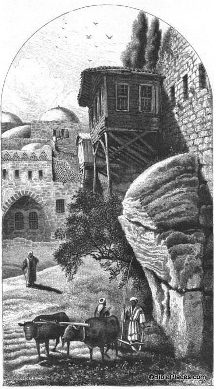
Our picture of the week, “Robinson’s Arch,” comes from a resource available through LifeInTheHolyLand.com, the sister site of BiblePlaces.com.  The resource is called Picturesque Palestine, Volume I: Jerusalem, Judah, and Ephraim.  It is part of the “Historic Views of the Holy Land” collection.  This was originally a book that was published in 1881 and edited by none other than Charles Wilson, one of the most prominent explorers of the Holy Land in the nineteenth century.  The book is a fascinating read as it discusses the landscape, holy sites, archaeological sites, and local culture as they appeared at that time.


Robinson’s “Arch” is really just the lowest section of what was originally an arch.  It is called Robinson’s Arch because it was discovered by Edward Robinson in the 1830s.  You can see the remains of the arch on the right half of this drawing, towering above the two men and the oxen.  The arch originally spanned across the Tyropean Valley in Jerusalem and formed the upper section of a long stairway that provided access to the Temple Mount during the time of Christ.  (A reconstruction of this stairway can be seen here.)  The Tyropean Valley was filled in over the years, beginning with the destruction of the Temple by the Romans in A.D. 70.  Over the centuries the area was built up and torn down over and over again, accumulating debris until it looked like this in the nineteenth century.

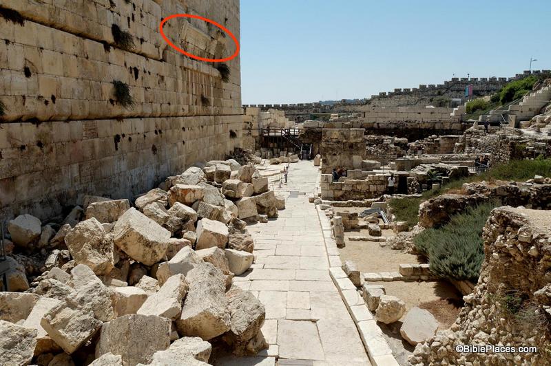
Returning to our question (“How much dirt does an archaeologist have to move?”), archaeologists in the 1960s–1990s had to move several meters of debris during their excavation of this area.  The picture above is what the area looked like in the 1870s.  Compare that with what it looks like today:

This picture (taken from the Jerusalem volume of the PLBL) is looking at Robinson’s Arch from the opposite direction as the drawing in Picturesque Palestine.  The arch is at the top of the photograph and circled in red in this photo.  You can see that it now towers over the remains of the 1st-century street below.  If you look carefully, there is a person standing on the street looking up at the arch.  That gives you an idea of the massive amount of dirt and stone that had to be moved by the excavation teams in recent decades.

This is just one example of the value of a work such as Picturesque Palestine.  It allows us to roll back the clock and see how the land appeared to the nineteenth century explorers before the excavations of the last 100 years.

This and other pictures of nineteenth-century Jerusalem are available in Picturesque Palestine, Volume I: Jerusalem, Judah, and Ephraim and can be purchased here.  Additional historic images of the Temple Mount can be seen here and here on the LifeInTheHolyLand.com website.  Several websites related to this topic can be found on the BiblePlaces website here.
Share:

(Post by Seth M. Rodriquez)

Having worked through the revised and expanded edition of the Pictorial Library of Bible Lands in this series, we will begin highlighting pictures in a lesser known (but extremely fascinating) series called Historic Views of the Holy Land.  This is a sister collection to the PLBL and is featured in a website called LifeInTheHolyLand.com.

Here is a brief description of the series from the website:


The Historic Views of the Holy Land series is an extensive collection of thousands of photographs, drawings, and maps of the biblical lands from the 19th and 20th centuries.   


The collection, upon which this website is based, features  

  • the most detailed and accurate maps of Palestine made before the birth of the state of Israel  
  • pictures from award-winning photographers who traveled through Egypt, Palestine, Lebanon, Syria, Turkey, and Greece in the 19th century  
  • photographs and drawings which illustrate biblical scenes, including Psalm 23, the Good Samaritan, and the Woman at the Well.

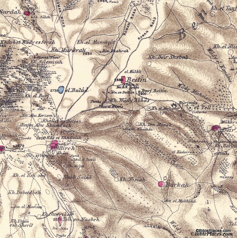
The first bullet point relates to our “Picture of the Week.”  These are the maps created by the Palestine Exploration Fund in the 1870s and published as the Survey of Western Palestine.  The maps contain an amazing amount of detail, were the most accurate maps produced in its day, and were created before the massive political and cultural changes were made in the country during the 20th century.  Produced at a scale of 1 inch to 1 mile, these maps are a treasure trove for students and scholars interested in biblical geography.  A full explanation of the maps and their value can be found here.

Our picture this week focuses on one small area of the maps: the region of Bethel and Ai.

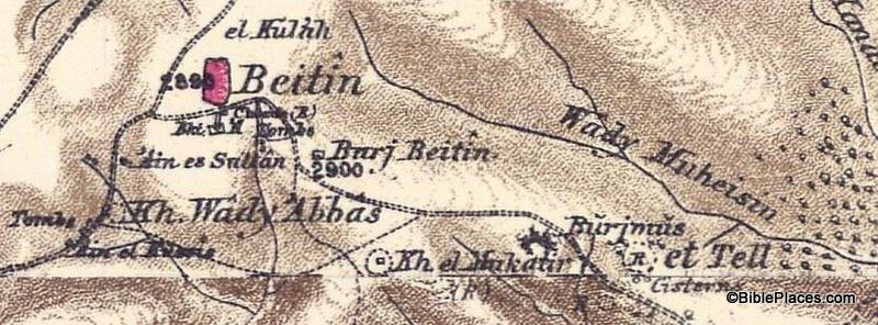
This section shows Beitin as a pink oval in the upper center of the map, which is usually identified as Bethel. It also shows et Tell in the right center and Khirbet el Mukatir to the east of et Tell.  The city of Ai (Gen. 12:8; Josh. 7:2) is identified by many scholars as et Tell, but the Associates for Biblical Research have been conducting excavations at Khirbet el Mukatir over the last couple of decades to investigate the possibility of identifying that site as Ai instead.  Below is an enlargement of the section of the map that shows Beitin, Kh. el Mukatir, and et Tell so that you can see the relationship between the three sites (click on the picture for a higher resolution):

This is just one example of the many uses of the Survey of Western Palestine Maps.  The originals of these maps are not easily accessible in libraries, but the electronic versions are available to all through the Historic Views of the Holy Land collection.

Further information and other images of the Survey of Western Palestine Maps can be found here.  You can download the index to the maps for free here, and you can purchase the maps by visiting here.  For another example of how these maps can be used, see my post on the Wild Olive Shoot blog here.

Share:

(Post by Seth M. Rodriquez)

Perhaps the most curious volume in the revised and expanded Pictorial Library of Bible Lands is the last one: Volume 18, “Signs of the Holy Land.” If you have never visited the Holy Land, then you don’t know what you’re missing! If you have been there, then you can imagine what humorous (and not-so-humorous) signs you can find in this collection.

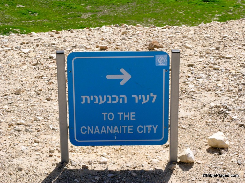
It goes without saying that English is not the primary language of any of the biblical regions today, so the charm of many of these signs lies in the fact that the grammar, spelling, and choice of words are frequently not the most eloquent. “This Holly Church,” “Danger of Death,” “You Are Hear,” and “Bewar of Loose Rocks” are just some of what you will find when you visit the Holly Land … I mean, Holy Land.  Or perhaps you will run across this one:

With directions like these, it’s no wonder the Israelites had to wander in the wilderness for 40 years. (How do you even pronounce that?!)

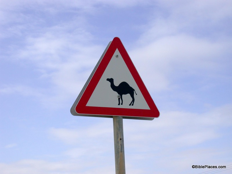
Another source of their charm is in the cultural differences that they reveal. Some of these differences are rather serious: such as signs requiring modest clothing in certain areas, signs warning you of a mine field, or signs of Jews denouncing Arabs or of Arabs denouncing Jews. But some of these are quite humorous, such as “Temptation Restaurant” in Jericho (near the traditional Mount of Temptation), signs forbidding honking, an advertisement for windsurfing on the Sea of Galilee, and “Do not play soccer on the grass!” (You can just hear the municipality’s frustration with the local youth in that last one.) Or, one of my personal favorites, this sign for a camel crossing taken by Daniel Frese:

Perhaps we are not as far removed from the time of Abraham as we think we are.

Yet much of their charm comes from the fact that these are modern signs that often reference biblical people, places, and events. One of the values of visiting the Holy Land is that it helps you connect with the Bible in a unique way because you are there. You are in the same place where the drama of the Bible unfolded. Seeing road signs that reference the cities of Jerusalem, Bethlehem, Jericho, Nazareth, Tarsus, or Corinth drives home the point that you are in the land of the Bible. You also will see streets and shops named after biblical events or people. 

Much of this volume of the PLBL is devoted to such signs. Biblical people, places, and events are part of the lifeblood of these cultures and this is evident in how they name things. Most of the time, these references are intentional and add dignity to a place. However, I’m not sure that the people who named the “Kfar Shaul (Village of Saul) Mental Health Center” really thought through all the biblical associations:

If only this place had existed in Saul’s day then maybe he wouldn’t have needed to hire David to play music for him (1 Sam. 16:14-16).

There are so many interesting signs in this collection that I couldn’t narrow it down to just one for this post, so once again I broke tradition by giving you three. And although this volume may be one of my personal favorites, you may be wondering, “What in the world would I use these pictures for?” So here are some ideas for you …

  • Ice Breakers for a Lesson or Sermon
  • Teaching Illustrations
  • Humor
  • Attention Grabbers
  • Demonstrating the Relative Geographical Location of One Site to Another (using highway signs)
  • Hebrew or Arabic Vocab Lessons and Tests (gleaned from real-life examples)
  • Lessons in Jewish and Arab Culture
  • Decorative Art for a Bulletin or Brochure

I’m sure the readers of this blog can think of more uses than that, and you are welcome to leave your ideas in the comment section. Until next time … drive safely, watch out for passing camels, and (as one sign in Cyprus puts it) remember that “Driving in the lake is forbidden.”

These and other photos of “Signs of the Holy Land” are included in Volume 18 of the Pictorial Library of Bible Lands and can be purchased here.

Share:

(Post by Seth M. Rodriquez)

Someone recently asked me, “Can you understand the Bible without understanding the culture of the people in the Bible?”

My answer was: “Yes, you can understand the Bible without knowing the cultural background.  The Bible was written in such a way that anyone can understand its main message.  However, an understanding of the biblical backgrounds allows you to understand that message with greater depth.”

Isaiah 63 is a good example of this:

Who is this who comes from Edom,

    in crimsoned garments from Bozrah,
he who is splendid in his apparel,
    marching in the greatness of his strength?
“It is I, speaking in righteousness,
    mighty to save.”
Why is your apparel red,
    and your garments like his who treads in the winepress?
“I have trodden the winepress alone,
    and from the peoples no one was with me;
I trod them in my anger
    and trampled them in my wrath;
their lifeblood spattered on my garments,
    and stained all my apparel.” (Isa. 63:1-3, ESV)

Revelation 19:15 uses the same imagery when describing Jesus returning to triumph over His enemies:

From his mouth comes a sharp sword with which to strike down the nations, and he will rule them with a rod of iron. He will tread the winepress of the fury of the wrath of God the Almighty. (Rev. 19:15, ESV)

In poetic language, these passage describes a day when God will execute his wrath on the earth. That is the main message.  However, an understanding of the ancient practice of treading a winepress brings a fuller understanding of the imagery used here.

Our picture of the week comes from Volume 17 of the revised and expanded edition of the Pictorial Library of Bible Lands, which provides “Cultural Images of the Holy Land.”  Like Volume 16, which we discussed last week, this is a new volume of the PLBL.  It covers such cultural images as animals familiar in the biblical world (both domestic and wild), agricultural practices, Jewish cultural practicesJewish holidays, Christian holidays, the Samaritan Passover ceremony, various types of dwellings, sources of water, shepherding, pottery making, scribes, and more.  It is a valuable resource for any Bible teacher or preacher who wants to help people understand the biblical world.

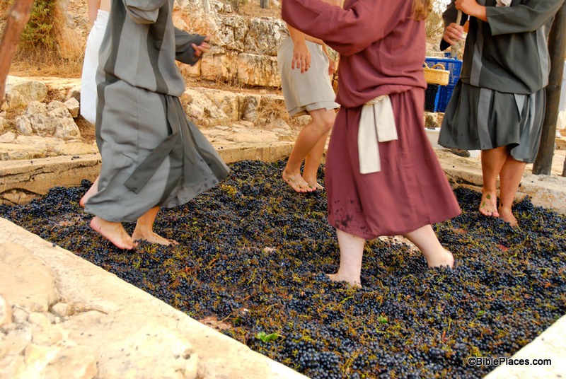
The picture is entitled simply “Treading Winepress.” It is one of a series of photos in the collection where people are reenacting the process of harvesting and treading grapes. At once, you can understand why it is called “treading” as you see the people stomping on the grapes to release the juice.  (As a side note, the juice then drained out of the winepress through a hole on one end of the vat.)

You can also see why God is asked “Why is your apparel red, and your garments like his who treads in the winepress?” (Isa. 63:2, ESV).  If you look closely at the bottom of their robes you will see that some of the red juice has splattered up onto the people’s clothes.  You can imagine what this scene would look like if someone was angry while treading out the grapes, stomping and smashing the fruit violently.  Even more juice would splatter and would look similar to blood (“their lifeblood spattered on my garments, and stained all my apparel,” Isa. 63:3).  Such a picture brings a deeper understanding of the biblical reference to Jesus in Revelation 19: “He will tread the winepress of the fury of the wrath of God the Almighty” (Rev. 19:15, ESV).

A collection such as this can be a valuable tool in the hand of a Bible teacher.  Illuminating the biblical background helps illuminate the Bible itself.

This and other photos of “Cultural Images of the Holy Land” are included in Volume 17 of the Pictorial Library of Bible Lands and can be purchased here.  Additional information and pictures of cultural images can be found here and here on the BiblePlaces website.  Those interested in this topic should also check out the many resources listed on the sister website of BiblePlaces at www.lifeintheholyland.com.

Share:

(Post by Seth M. Rodriquez)

Look around where you are sitting for things that are the color brown.  Then look for things that are red or blue.  You will probably be surprised at how many things you can spot that are those colors, and you never really notice how many there are until you specifically look for them.

The same can be said for plants mentioned in the Bible.  As you are reading through the scriptures, you probably don’t even notice how many times trees or flowers or wheat or weeds are mentioned.  They are just part of the warp and woof of the text.  Yet when you stop to count them, it is shocking how often they appear.

Our picture of the week comes from Volume 16 of the revised and expanded edition of the Pictorial Library of Bible Lands, which focuses on “Trees, Plants, and Flowers of the Holy Land.”  This is an entirely new volume of the PLBL.  A small number of the pictures in this volume were included in the previous version but they were scattered throughout the collection based on their location.  This new volume collects these photos together in one place and adds numerous new photos, creating a powerful tool for learning about biblical plant life.  Looking over the list of pictures included in the collection (which can be found here) the collection includes photographs of:

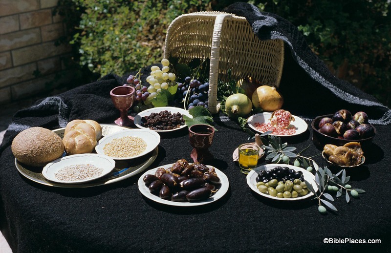
Numerous photographs in this new volume were taken by Gloria E. M. Suess, who was a long-term volunteer at the Institute of Holy Land Studies in Jerusalem and an avid photographer of biblical plants.  Our picture of the week was taken by her and is entitled “Seven Species Display.”  (Click on the photo for a higher resolution.)

The seven species represented here are the seven types referred to by Moses in Deuteronomy 8:7-10.

For the Lord your God is bringing you into a good land, a land of brooks of water, of fountains and springs, flowing out in the valleys and hills, a land of wheat and barley, of vines and fig trees and pomegranates, a land of olive trees and honey, a land in which you will eat bread without scarcity, in which you will lack nothing, a land whose stones are iron, and out of whose hills you can dig copper. And you shall eat and be full, and you shall bless the Lord your God for the good land he has given you.  (Deuteronomy 8:7-10, ESV)

This photo captures all seven varieties of products in one shot.  Barley and wheat are at the far left, each represented by its grains and a loaf of bread made from that type of grain.  Vines are represented at the top of the photo by three types of grapes, along with a cup of wine and a plate of raisins.  Figs are at the far right side of the picture: fresh figs (top) and dried figs (bottom).  Pomegranates (two whole and one opened) can be seen at the top of the photo between the grapes and figs.  Olives are shown at the lower right side: both green and black olives along with a cup of olive oil, an oil lamp (behind the cup), and a branch from an olive tree.

Lastly, honey is represented by dates at the bottom center of the photo.  The juice that was squeezed from fresh dates was known as date honey, and can be seen in the cup just above the plate of fresh and dried dates.  Some scholars believe that date honey instead of bee honey makes the most sense in this list of agricultural products.

Once again, a picture is worth a thousand words.  Seeing all seven species together on one table whets that appetite and drives home the message in a different way than merely reading the text.  Looking at this feast, it is easy to see that this truly was a “good land” that God was giving to the Israelites.

This and other photos of biblical plant life are included in Volume 16 of the Pictorial Library of Bible Lands and can be purchased here.  For further thoughts on why Moses may have chosen to mention these seven species, see my blog post on the Wild Olive Shoot blog here.

Share:

(Post by Seth M. Rodriquez)

When people think of “biblical archaeology” they usually think of cities such as Jerusalem, Jericho, or Capernaum.  However, sometimes a road can be just as valuable as an archaeological “site.”

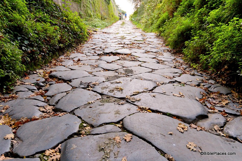
Our picture of the week is from Volume 15 of the revised and expanded version of the Pictorial Library of Bible Lands, which focuses on Rome. The photo is entitled, “Appian Way with Ancient Paving Stones.”

Although never explicitly mentioned in Acts 28, there can be little doubt that the Apostle Paul walked this road as he traveled from Puteoli (Acts 28:13) to Rome (Acts 28:14).  From Puteoli, Paul and his escort of Roman soldiers probably travelled north to Capuae (also spelled Capua) where they travelled the rest of the journey to Rome on the Appian Way.  In his 1962 work on Archaeology and the New Testament, Merrill F. Unger describes the journey in this way:

Not far from Puteoli at Capua, Paul and the group got on the Appian Way which connected with Rome via The Forum of Appius and The Three Taverns.  Extensive sections of this well-paved road, planned by the censor Appius Claudius Caecus in 312 B.C., still exist, lined with tombs, sites of ancient Roman villas, and ruins of ancient aqueducts. … From Capua it was 132 miles to Rome. …

Since the Appian Way from Capua to Terracina Romeward skirted near the shore, picturesque vistas of land often combined with a magnificent view of the sea. …

At the Forum of Appius, 43 miles from the metropolis on the Tiber, Paul and the group had a pleasant surprise.  Some of the believers at Rome, Luke writes, “came to meet us” (Acts 28:15), employing a word (apantēsis) technically used for the official welcome of a visiting dignitary by a deputation which went out of a city to greet him and conduct him on his way for the last part of his journey. …

Now on both sides of the Appian Way were seen the tombs and funerary memorials of the generals, conquerors, and distinguished men who had raised an obscure Italian town to the position of the first city of the world, and surrounded it with a halo of martial glory unexcelled by any other metropolis.  Many of these illustrious Romans had passed over this same road to enjoy a magnificent triumph in the city.  But the prisoner who that day was surrounded by a retinue of converts and a few Roman soldiers was being led in a triumph far more memorable than that of any victorious Roman general.

Excerpt is taken from Merrill F. Unger, Archaeology and the New Testament (Grand Rapids: Zondervan, 1962), 314-316, and can be purchased here.  This and other photos of Rome are included in Volume 15 of the Pictorial Library of Bible Lands and can be purchased here.

Share: