fbpx

(Post by Seth M. Rodriquez)

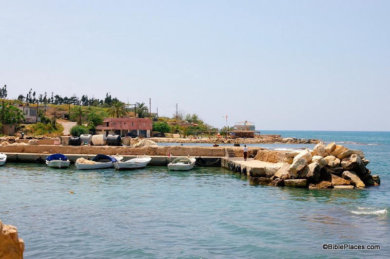
“What do you know about the biblical city of Zarephath?  Where is it mentioned in the Bible?  What biblical events happened there?”  It is a well-known fact that while teaching or preaching, it is helpful to start your dialogue by asking questions that will gain the attention of your listeners.  In addition, in today’s day and age where so much of people’s intake of information is visual, this technique can be even more effective if it is coupled with a picture, such as this one:

Although the photo and the name of Zarephath may not be familiar to most people (even people who are familiar with the Bible), the significance of the place will become evident to your listeners when you connect it with the biblical references to this place.  In other words, it becomes a springboard to an important biblical story.

This week’s photo comes from Volume 8 of the revised and expanded edition of the Pictorial Library of Bible Lands, which focuses on Lebanon. The photo is entitled “Zarephath, Phoenician Harbor and Tell from East” (photo ID #: adr090508617).  Volume 8 is part of the “expanded” features of the PLBL.  It is a completely new volume featuring the pictures of A.D. Riddle, a frequent contributor to this blog.

So where is Zarephath and what is its biblical significance?  Zarephath is an ancient city on the coast of Phoenicia, about 8 miles (13 km) south of Sidon and 14 miles (22 km) north of Tyre.  In antiquity, it had a long and productive existence: it was inhabited from the Late Bronze Period (1600 BC) through the Byzantine Period (AD 600), so it was standing in both Old Testament and New Testament times.  There is also a modern village about a mile from the site today.  Naturally the name of the town changed over the years and as you moved from one culture to another: it was referred to as “Zarephath” by the Israelites, “Sarpu’uta” by the Egyptians, “Sariiptu” by the Assyrians, “Sarepta” by those in Hellenistic and Roman times, and “Sarafand” today.

Zarephath occurs in two chapters in the Bible: 1 Kings 17 and Luke 4.  In the book of 1 Kings, Zarephath is the town where the Lord instructed Elijah to go during the last part of the three-year of drought in Israel.

Then the word of the Lord came to him, “Arise, go to Zarephath, which belongs to Sidon, and dwell there. Behold, I have commanded a widow there to feed you.” (1 Kgs. 17:8-9, ESV)

While he was there, the Lord provided for Elijah, the widow, and her son in a miraculous fashion.  This was followed by another miracle when the widow’s son died and the prophet raised him back to life.

The drought ended in the next chapter, 1 Kings 18, after Elijah confronted the prophets of Baal on the top of Mount Carmel.  In a way, the events in Zarephath were a subtle precursor to the dramatic confrontation in 1 Kings 18.  Zarephath was in the territory of Sidon, the homeland of Queen Jezebel and a region where Baal was worshipped.  In fact, Jezebel was the one responsible for making Baal worship the official state religion in Israel after she married King Ahab, as 1 King 21:25-26 makes clear.  In light of all this, Elijah’s words to the widow in chapter 17 are significant:

For thus says the Lord, the God of Israel, “The jar of flour shall not be spent, and the jug of oil shall not be empty, until the day that the Lord sends rain upon the earth.” (1 Kgs. 17:14, ESV, emphasis added)

This was a bold claim in the territory of Baal-worshippers: the God of the Israelites will perform a miracle on your behalf, not the god of the Sidonians.  The widow herself seems to have already had faith in the God of Israel (1 Kgs. 17:12), but when 1 Kings 17 is studied in context with 1 Kings 18 the theme seems to be that God is mightier than the false god Baal.

Finally, in Luke 4:24-26, Jesus references these events while discussing the fact that a prophet has no honor in his hometown.  Jesus was almost stoned after saying this, probably because he used examples where Israelite prophets were used as a means of blessings to Gentiles … a truth that was not very palatable in 1st century Galilee.

This and other photos of the Zarephath are included in Volume 8 of the Pictorial Library of Bible Lands and can be purchased here. More information and photos about Zarephath can be found on the BiblePlaces website here.
Share:

(Post by Seth M. Rodriquez)

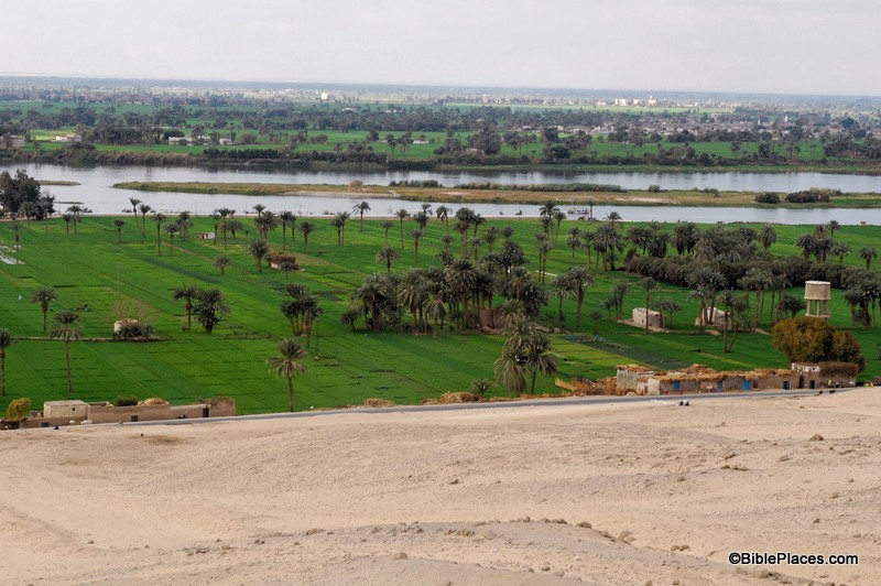
As I’ve pointed out before in this series, pictures can be powerful tools in the hands of the Bible teacher.  The right picture can illuminate a passage and bring deeper understanding.  This week’s photo is another example.  It comes from Volume 7 of the revised and expanded edition of the Pictorial Library of Bible Lands, which focuses on Egypt.  The photo is entitled “Nile River Valley Near Beni Hasan Tombs from East” (photo ID #: tb010805121).

When the Israelites were about to enter the Promised Land, Moses contrasted the land of Egypt with the land of Canaan:

For the land, into which you are entering to possess it, is not like the land of Egypt from which you came, where you used to sow your seed and water it with your foot like a vegetable garden. But the land into which you are about to cross to possess it, a land of hills and valleys, drinks water from the rain of heaven, a land for which the Lord your God cares; the eyes of the Lord your God are always on it, from the beginning even to the end of the year. (Deut. 11:10-12, NASB)

In the context of the chapter, Moses is warning the people to obey God’s commandments so that they will prosper in the land.  He explains that life in the Promised Land will be very different than it was in Egypt, and this week’s photo helps explain why.

The agriculture of Egypt is based on the water from the Nile.  Farmers plant their crops in the flat land around the Nile, in part, because they have easy access to water from there.  The phrase in verse 10 “sow your seed and water it with your foot” has produced a number of interpretations, such as carrying the water by foot in buckets, digging channels with one’s feet, and using a mechanical device that is powered by foot.  Whatever the correct interpretation, the point is that in Egypt it was possible to provide water for your crops by mere manpower.  In this week’s photo, you can see the relationship between the farmland and the Nile, and it is clear from this picture that it would be a relatively easy task to get water from the Nile to the crops growing nearby.

By contrast, the agriculture of Canaan is vastly different.  There is no convenient and reliable natural source of water for the farmer’s crops.  In contrast to the flat farmlands that surround the Nile, Canaan is “a land of hills and valleys,” which makes moving water from one place to another difficult.  And the only major river that flows through the land, the Jordan, is below sea level for most of its course and is basically useless for irrigation.  Before the advent of modern machinery, the only way the fields could be watered was by rain.

 
So in Deuteronomy 11, Moses warns the people that they must obey God to thrive in the Promised Land.  If they obey, then God will send the rain and they will have food (Deut. 11:13-15).  If they don’t, then:
 

He will shut up the heavens so that there will be no rain and the ground will not yield its fruit; and you will perish quickly from the good land which the Lord is giving you. (Deut. 11:17, NASB)


The land to which God was leading His people was a land that required them to walk by faith and depend on Him.
 
This and other photos of the Nile Valley are included in Volume 7 of the Pictorial Library of Bible Lands and can be purchased here. More information and photos about the Nile River can be found on the BiblePlaces website here.  For more thoughts on how the Land of Israel was a land that fostered faith, see my post here.
Share:

(Post by Seth M. Rodriquez)

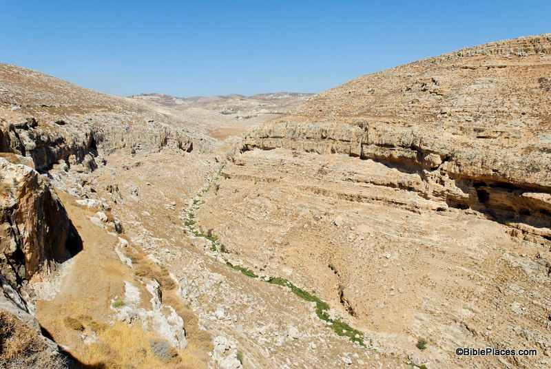
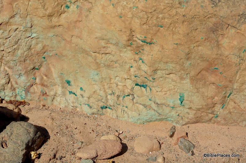
This week’s photo comes from Volume 6 of the revised and expanded edition of the Pictorial Library of Bible Lands, which provides a collection of pictures from the country of Jordan.  In my introduction to this series, I promised to highlight “the more unusual pictures that illustrate a particular feature of geography or archaeology that can be easily overlooked or that other photo collections fail to include.”  So this week’s picture is not a stunning photo of the ruins of Petra or the amazing Roman city of Gerasa or even the biblically significant Mount Nebo and Plains of Moab (although the new edition of the PLBL has new photos of each of those places).  Instead, this week’s photo was taken south of the Dead Sea in Wadi Jariya and focuses on a small section of bedrock.  It is entitled “Wadi Jariya Exposed Copper Ore in Bedrock” (photo ID #: df070807104) and was taken by Dr. Daniel Frese.  (Click on the photo for a higher resolution.)

You will never see this picture framed in a Sunday School classroom or hanging over someone’s mantelpiece, but it can go a long way in illuminating Deuteronomy 8:9 and is useful when explaining the process of ancient copper mining.

Deuteronomy 8:9 states that copper could be dug “out of the hills” in the land of Canaan.  Although Wadi Jariya lies within the territory of Edom and is outside the borders of the Promised Land, the process was similar there.  In the photo, the green specks on the rock are the copper ore.  This ore was chiseled out of the rock and then refined through a smelting process which removed the impurities.  When the impurities cooled, they formed a solid, dark substance called slag.  At various locations in Israel and Jordan (as well as elsewhere in the Middle East) large amounts of slag are left over from antiquity.  In fact at Khirbet en-Nahas, a neighboring site to the Wadi Jariya operation, a slag pile over 20 feet deep has been discovered.

Copper mining was an important element of the ancient economy since copper was used extensively in that society.  Usually the copper was mixed with a little bit of tin and was thus transformed into bronze, a strong metal sometimes used in scripture to refer to someone or something hard or stubborn (Deut. 28:23; Jer. 1:18; 6:28).  Bronze was used to make many things in biblical times, such as utensils (Exod. 38:3), weapons (1 Sam. 17:6), chains (2 Kgs. 25:7), and cymbals (1 Chr. 15:19) to name a few.  Its value is seen in the fact that it was listed among the spoils of war along with gold, silver and iron (Josh. 6:19, 24).  But its humble beginnings can be traced back to this picture … as a green speck within a hard rock found in a dry valley.

This and other photos related to copper mining are included in Volume 6 of the Pictorial Library of Bible Lands and can be purchased here.  More information and photos about copper mining can be found on the BiblePlaces website here.
Share:

(Post by Seth M. Rodriquez)

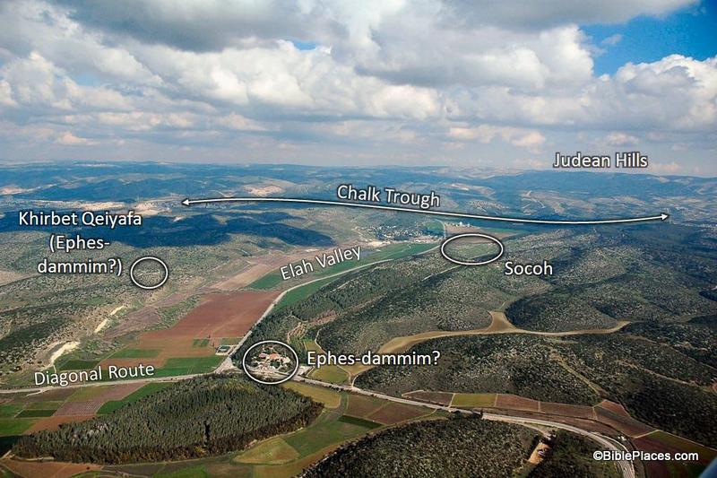
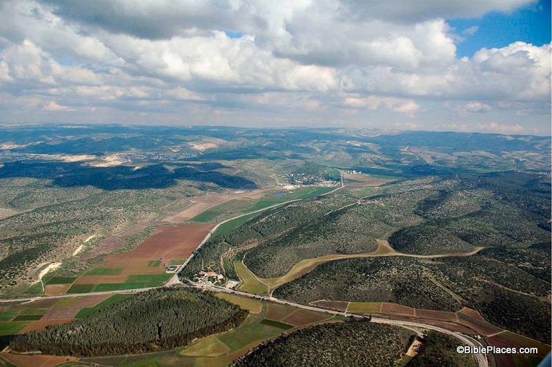
This week’s photo comes from Volume 4 of the revised and expanded edition of the Pictorial Library of Bible Lands and is entitled “Elah Valley Aerial from West” (photo ID #: tb011606772).  One of the improvements in the new edition of the collection is the addition of some aerial photos of the Elah Valley which make it easy to pick out the valley from among the hills of the Shephelah.  In the photo above, the valley can be seen starting at the bottom left corner, moving diagonally up to the center.  (Click on the photo for a higher resolution.)

This photo is extremely useful when discussing the encounter of David and Goliath.  First Samuel 17 sets the stage in the following way:

Now the Philistines gathered their armies for battle. And they were gathered at Socoh, which belongs to Judah, and encamped between Socoh and Azekah, in Ephes-dammim. And Saul and the men of Israel were gathered, and encamped in the Valley of Elah, and drew up in line of battle against the Philistines. And the Philistines stood on the mountain on the one side, and Israel stood on the mountain on the other side, with a valley between them. (1 Sam. 17:1-3, ESV.)

Most of the locations in this passage are visible in this picture.  To assist in identifying them, I’m going to pull from one of the PowerPoint presentations included in the Pictorial Library collection:

In this slide the location of the Elah Valley and Socoh are clearly marked, along with possible locations of Ephes-dammim.  Azekah is not pictured here, but is located just off the photo to the left.  You can easily imagine the Philistine army on one side of the valley and the Israelites on the other, just as it is described in verse 3.

In the background, the Judean Hills are marked which adds to the value of this photo.  When teaching on David and Goliath, I like to point out to my listeners that there was much at stake for David in this battle.  Not only were the Israelite soldiers facing a deadly enemy and not only was the reputation of Israel’s God on the line, but there was another element that we tend not to think about which relates to geography.  If you look at a map of this area you will see that the Elah Valley is an entryway into the Hill Country of Judah, the region where David and his family lived.  Three thousand years after the fact we have the advantage of knowing how it turned out, but if David had lost the battle it is possible that the Philistines would have penetrated into the Judean Hills (as they had when they were encamped at Michmash on the Central Benjamin Plateau).  This would have put David’s family and neighbors at serious risk.  So as David faced Goliath, he was not only fighting for his people and his God … he also was fighting for the safety of his own hometown.

This photo is included in Volume 4 of the Pictorial Library of Bible Lands and can be purchased here.

Share:

(Guest post by Seth M. Rodriquez.)

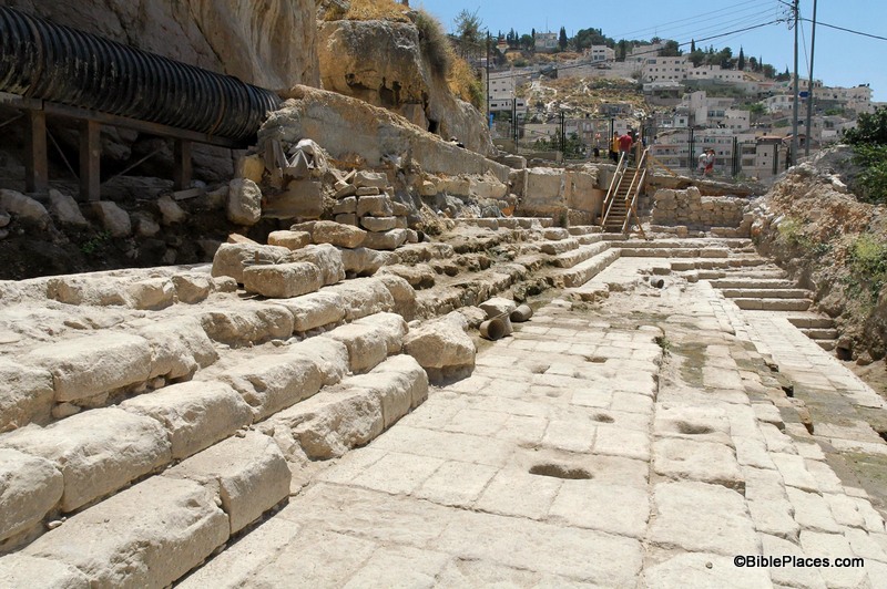
One of the most impressive additions to Volume 3 of the revised and expanded Pictorial Library of Bible Lands are the photos of the newly discovered Pool of Siloam.  The original Pictorial Library was published in 2003 and the 1st century Pool of Siloam was discovered one year later.  So naturally the original collection did not include any pictures of this significant site, but the revised version includes over 30.  So this week’s photo comes from Volume 3 of the revised and expanded edition and is entitled “Pool of Siloam Excavations” (photo ID #: tb070305450).

First, a note of explanation:  If you have ever been to Israel and have walked through Hezekiah’s Tunnel, you were probably told that the small pool at the end of the tunnel was the Pool of Siloam. 

That is true but it should be clarified that that is the Pool of Siloam from the Byzantine period (AD 324-640).  The pool pictured above is the Pool of Siloam that existed in the 1st century AD.  This is a much larger pool than the Byzantine pool.  The side that has been excavated is 160 feet long (50 meters).  There are three groups of steps leading down, with each group containing five steps.  The fifth step of each group is much longer than the others and probably served as a platform for bathers to stand on.

This Pool of Siloam is the one that existed during the time of Jesus and His disciples.  In fact, John 9 tells us that a miraculous healing occurred at this very spot.  As they are leaving the Temple, Jesus and the disciples see a man who has been blind since his birth and the disciples ask Jesus a question that probably was debated by the leading religious minds of their day: “Who sinned, this man or his parents, that he was born blind?” (John 9:2, ESV.)  The question gives Jesus the opportunity to teach them an important lesson that corrected their thinking and now serves as a comfort for all who have ever wrestled with incurable physical ailments: “It was not that this man sinned, or his parents, but that the works of God might be displayed in him.” (John 9:3, ESV.)  Then Jesus made some mud by spitting on the ground, placed it on the man’s eyes, and told him to wash in the very pool pictured above: “Go, wash in the pool of Siloam” (John 9:7, ESV).  The man followed Jesus’ command and could see after he washed the mud off his eyes.

Unfortunately only part of the pool has been excavated.  The rest of it sits under an orchard that the owners are not willing to remove (the last I’ve heard).  Hopefully that situation will change in the near future so that more of this important pool can be exposed.

Additional photos and more information about the newly discovered Pool of Siloam are available here and here on the BiblePlaces website.  Previous posts on this blog about the pool (which are numerous) can be found here.  This photo, along with over 30 other pictures of the pool, is included in Volume 3 of the Pictorial Library of Bible Lands and can be purchased here.

Share:

 (Guest post by Seth M. Rodriquez. For an introduction to this series, see last week’s post.)

This week’s photo comes from Volume 2 of the revised and expanded edition of the Pictorial Library of Bible Lands.  It is entitled “Cliffs Near Michmash and Geba from Southeast” (photo ID #: tb092706140).  However, the name of the picture does not do justice to the thrilling events that took place here in the time of King Saul.

First Samuel 13 tells us that shortly after Saul was crowned king, the Philistines had penetrated deep into Israelite territory.  Normally the Philistines controlled only the coastal plains, but at this point in history they were attempting to gain control over the hill country as well.  They were encamped at Michmash in the territory of Benjamin, in the heart of Israelite territory (1 Sam 13:5).  Saul mustered his troops but suffered a defeat (1 Sam 13:6-7).  He was in dire straits and his character was put to the test as he waited for Samuel to arrive and offer sacrifice on behalf of the troops (1 Sam 13:8).  Saul cracked  under the strain and offered the sacrifice himself, incurring God’s judgment (1 Sam 13:9-15).  This chain of events only made matters worse and the Philistine army started spreading out from Michmash, gaining control over the heart of Saul’s kingdom (1 Sam 13:16-18).

This was the situation that Jonathan found himself in, yet unlike his father his character blossomed under such difficult circumstances.  First Samuel 14 provides us with the story.  The picture above shows the cliffs that separated the Philistine camp at Michmash and the Israelite camp at Geba.  The modern name for this valley is the Wadi Suweinit.  The cliffs on the left side of the photo led to Geba and the cliffs on the right to Michmash.  The Bible refers to these cliffs in this way:

“Within the passes, by which Jonathan sought to go over to the Philistine garrison, there was a rocky crag on the one side and a rocky crag on the other side. The name of the one was Bozez, and the name of the other Seneh. The one crag rose on the north in front of Michmash, and the other on the south in front of Geba.” (1 Sam. 14:4-5, ESV.)

The camps were only about a mile apart.  There is a pass between the two sites at the head of the valley (near the top center of the photo) where the main road was and still is today.  That strategic pass through the area was probably the reason the Philistine soldiers chose to camp at Michmash: if they camped close by, they could monitor and control the traffic through the pass.

However, instead of approaching the Philistine garrison on the main road through the pass, Jonathan decided to surprise the Philistines by scaling the cliffs.  Verse 13 tells us that Jonathan climbed up to the Philistine camp “on his hands and his feet.”  Amazingly, he takes only his equipment bearer with him: two soldiers against an entire garrison.  His reasoning for the attack is a testimony to his great faith:

“Come, let us go over to the garrison of these uncircumcised.  It may be that the Lord will work for us, for nothing can hinder the Lord from saving by many or by few.” (1 Sam 14:6, ESV.)

In the end, God rewarded Jonathan’s faith by giving him the victory.  He and his equipment bearer killed 20 soldiers and the rest were thrown into a panic (1 Sam 14:14-15), which provided the Israelites with an opportunity to win a great victory.  (You can read the rest of the story here.)  Many things have changed in the land of Saul and Jonathan over the last 3,000 years, but these cliffs still stand today as a silent witness of the faith and heroic deeds of Jonathan.

This photo is included in Volume 2, “Samaria and the Center” of the Pictorial Library of Bible Lands can be purchased here.
For more on Michmash, Geba and the pass, go here.

Share: