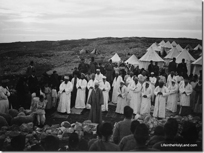
Ferrell Jenkins reports on tonight’s celebration of the Passover by Samaritans on Mount Gerizim. His blogpost includes photos and links.
From the Jerusalem Post:
Snow flurries drifted to the ground on Mount Gerizim overlooking Nablus on Thursday, as mourners gathered to bury the spiritual leader of the Samaritans, who passed away the previous day.
High Priest Elazar ben Tsedaka ben Yitzhaq was born during a snowstorm 83 years ago, one mourner said. On Thursday, as he was being laid to rest at the holiest site in the Samaritan religion, the snow began to fall again.
According to Samaritan tradition he was the 131st holder of the post since Aaron. This is not be accepted by all historians, but the office may well go back to the Hellenistic period, which would still make it the oldest office in the world. One account in Josephus suggest that it is an offshoot of the Zadokite high priests in Jerusalem from around the time of Alexander the Great.
Mourners took shelter from the storm inside the community center in the hilltop neighborhood of Kiryat Luza, where much of the ethnoreligious group of 730 lives. Nearly all the rest live in Holon’s Neveh Pinchas neighborhood.
Inside, well over 100 men gathered in a somber, eerily quiet ceremony around the casket holding Elazar, who will be replaced as head priest by his cousin Aharon Ben-Av Hisda Cohen.
The Samaritans are a tiny, largely misunderstood sect that practices a religion that is a close parallel to Judaism. Samaritans believe theirs is the true religion of the Israelites and follow their own Samarian Torah, written in an ancient form of Hebrew largely alien to modern Israeli eyes. Today’s Samarians trace their lineage to Israelites who have lived in northern Samaria before the Babylonian exile, and they still view Mount Gerizim, not Jerusalem, as the center of their religion.
According to his obituary on the Samaritan Update website, Elazar ben Tsedaka became high priest in 2004. At the time of his appointment, it was written:
The new High priest is a prominent scholar in the community, a poet, and an expert in the calculation of the Samaritan yearly calendar. He was born in Nablus/Samaria in 1927. He had been a high school teacher of mathematics for many years in Nablus and after his retirement devoted himself to matters of the priesthood, literature and research. High Priest Elazar participated in research delegations on Samaritan manuscripts in St. Petersburg in 1991 and in political issues to Washington D.C. in 1995.
The Samaritan Update also has a list of high priests from 1624 until present.
Future dates of the celebration of the Samaritan Passover sacrifice are also given:
- Wednesday, April 28, 2010
- Sunday, April 17, 2011
- Friday, May 3, 2012
- Tuesday, April 23, 2013
- Sunday, April, 13, 2014
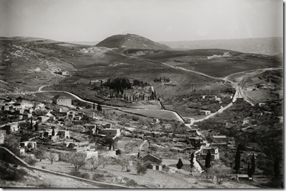
This photo is from the Traditional Life and Customs volume of The American Colony and Eric Matson Collection (Library of Congress, LC-matpc-01845).
- Tagged American Colony Photos, Samaria
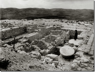
King Herod built a magnificent temple in Jerusalem, but not as many people are aware that he built three other temples in the land of Israel, all to Gentile deities. The ancient capital of the northern kingdom, Samaria, was renamed Sebaste by Herod in honor of Emperor Augustus, and he constructed a temple here dedicated to the emperor.
Samaria/Sebaste was first excavated by Harvard University from 1908 to 1910 under the direction of George Andrew Reisner. The photo below shows the foundations of Herod’s temple shortly after those excavations.
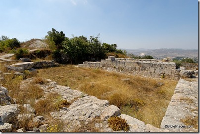
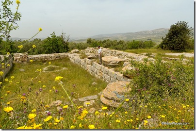
Today this area is largely filled in and overgrown, with only a few walls and pillar bases visible. The political situation today makes it difficult for most tourists to visit the site.
Herod’s temple foundations, view from northwest
Herod’s temple foundations, view from southeast
The first photograph is one of 600 high-resolution images in the newly released Northern Palestine CD, volume 1 of The American Colony and Eric Matson Collection. Photo: Library of Congress, LC-matpc-07375.
- Tagged American Colony Photos, Samaria, Then and Now
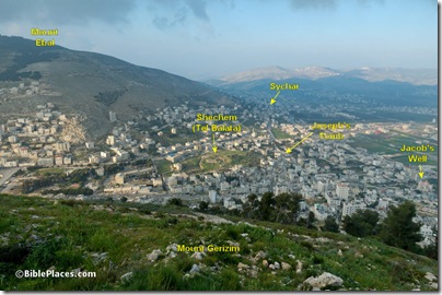
Those who have traveled with me can readily attest that one of my favorite sites in the land of Israel is the Shechem area. In recent years, I’ve been able to do no more than stand on top of Mount Gerizim or view the area from the east, but even that is quite satisfying. My love for the area is not necessarily related to anything the eye can see today. There are other hills, valleys, tells, and impressive views. But the acts of God make this area unlike any other. Here the Lord promised the land to Abraham. Here Jacob erected an altar and apparently dug a well. Here the twelve tribes recited the blessings and curses. The list goes on, and it is long and rich.
Shechem area from Mount Gerizim, 2006
Standing atop Mount Gerizim and gazing over this panorama is one of my favorite things to do. But it could be better. It would be better if dense urbanization did not obscure the historic sites. It would be better if the loud noises of modern city life did not disturb my thoughts. It would be better if Israeli soldiers weren’t on guard around the corner. And it would be better if there was peace in the land and I could walk down the slope, into ancient Shechem, and then up the slope of Mount Ebal.
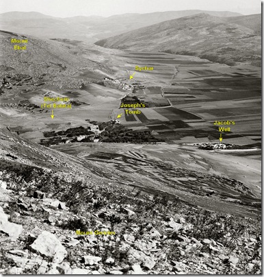
If I had lived 100 years ago, I could have done all of that. I can’t do that, but I can enjoy the beauty of old photographs. This is one of my favorites.
This photograph is one of 600 high-resolution images in the new Northern Palestine CD, volume 1 of The American Colony and Eric Matson Collection. Photo: Library of Congress, LC-matpc-05142.
If you prefer to view the photos in a PowerPoint file where you can flip back and forth between them, you may download that here.
- Tagged American Colony Photos, Samaria, Then and Now
I am very excited to announce the release of a new photo collection from BiblePlaces.com and LifeintheHolyLand.com. The American Colony and Eric Matson Collection includes more than 4,000 high-resolution photographs taken by professional photographers living in Jerusalem from 1898 until the 1940s. I’ve worked with a team for the last five years organizing and improving this collection so that the photos are the highest quality, accurately identified, carefully organized, and elucidated by observations of well-known 19th-century explorers.
The collection spans 8 CD volumes and is being released one volume a month beginning this week.
Volume 1 is “Northern Palestine,” and it includes 600 photos organized in the following categories:
- Acco (11 photos)
- Benjamin (43 photos)
- Caesarea (31 photos)
- Caesarea Philippi (14 photos)

- Ephraim and Manasseh (34 photos)
- Galilee Hill Country (20 photos)
- Haifa (27 photos)
- Huleh Basin (12 photos)
- Jaffa (51 photos)
- Jezreel Valley (47 photos)
- Mount Carmel (15 photos)
- Mount Hermon (20 photos)
- Mount Tabor (12 photos)
- Nazareth (32 photos)
- Samaria city (19 photos)
- Sea of Galilee (41 photos)
- Sea of Galilee, Capernaum (31 photos)
- Sea of Galilee, Tabgha (15 photos)
- Sea of Galilee, Tiberias (39 photos) – free PowerPoint here
- Sharon Plain (17 photos)
- Shechem area (22 photos)
- Tel Aviv (43 photos)
All images are included in high-resolution jpg format as well as in annotated PowerPoint files. The cost for the CD is now only $20, with free shipping in the U.S. While volumes 2-8 are not yet available individually, the complete collection is available in DVD format for $99.
I believe this is the finest collection of historic photographs of the Middle East available anywhere in any format.
You can read more about the collection here:
Complete Collection: Volumes 1-8
As with everything we do, the goal is your complete satisfaction. If you don’t like it or need it, return it for a full refund. If you do like it, we would really appreciate it if you’d pass the word on. Review copies are available by request.
I plan to post on this blog some interesting images from the CD over the next few weeks.
Aviva Bar-Am has written an informative article about ancient Jezreel and its modern counterparts in the Jerusalem Post. The first half discusses the battles around the village in 1948 and the kibbutz that was established there. The second half describes the biblical and archaeological significance, including this part:
Although archeologists have uncovered portions of a tower, found the city gate and dug to the bottom of the moat, the biblical Jezreel is overgrown with weeds and there isn’t much to see (I am also not sure how safe it is – there are open pits). It is much more fun to spend time at the tel’s excellent recreation site, centered by a striking monument to Palmah troops who fell here in 1948. From the heights of the tel you have a fantastic view of the Harod and Beit She’an valleys. Enjoy the shade produced by the fruit trees in the lovely reconstruction of Naboth’s plot.
You can also follow a lovely biblical trail on the northern edge of the mountain down the slope for about 35 minutes (allow about 50 minutes for walking back up). A delightful surprise awaits you at the bottom: the Jezreel Spring. It is one of 48 freshwater, full springs that lie under the mountain, the result of geological changes that occurred when the Syrian African Rift raised Mount Gilboa and lowered the valley.
Before you jump into the inviting pool, set within a grove of eucalyptus trees, look for a shaft a few meters from the end of the trail. It leads underground to a tunnel which you and your kids can enter (with a flashlight!), walk through water and end up on the other side of the road in a canal that leads directly to the pool.
The spring, of course, is mentioned in the Bible (isn’t everything in this region?) “The Philistines gathered all their forces at Aphek, and Israel camped by the spring in Jezreel…” [I Samuel 29:1].
The full article is here.
HT: Joe Lauer
Search
About the BiblePlaces Blog
The BiblePlaces Blog provides updates and analysis of the latest in biblical archaeology, history, and geography. Unless otherwise noted, the posts are written by Todd Bolen, PhD, Professor of Biblical Studies at The Master’s University.
Subscribe
Tags
10th Century
American Colony Photos
Analysis
Antiquities Trade
Dead Sea
Dead Sea Scrolls
Discoveries
Egypt
Excavations
Forgery
Galilee
Greece
Holidays
Israel's Coast
Italy
Jerusalem
Jezreel Valley
Jordan
Jordan Rift
Judah
Lebanon
Lectures
Mediterranean Islands
Mesopotamia
Museums
Negev
New Exhibits
Persia
Philistines
Photo Resources
Picture of the Week
Pseudo-Archaeology
Resources
Sad News
Samaria
Shephelah
Syria
Technology
Temple Mount
Tomb of Jesus
Tourism
Travels
Turkey
Weather
Weekend Roundup
Links
Notice
As an Amazon Associate we earn from qualifying purchases. In any case, we will provide honest advice.
