fbpx

Bryant Wood has posted some highlights of this season’s results at Khirbet el-Maqatir. The review includes a map, photos, and summaries of geographical and archaeological correspondences between Maqatir and biblical Ai.  You can read the whole; I’ll just quote here a portion of the introduction and a portion of the conclusion.

From the introduction:

After a hiatus of nine years, ABR has resumed work at Kh. el-Maqatir, a promising candidate for Joshua’s Ai (Joshua 7–8). The site is located approximately 9 mi north of Jerusalem and 0.6 mi west of et-Tell, the site most scholars identify as Joshua’s Ai. There is a major problem identifying et-Tell as Joshua’s Ai, however, as the site was unoccupied at the time of the Israelite Conquest of Canaan. ABR was founded 40 years ago to examine this problem and field work has been conducted both at Kh. Nisya (1979–2000; Livingston 2003) and Kh. el-Maqatir (1995–2000 [Wood 1999b, 1999c, 2000, 2008] and 2009) as part of the investigation. At Kh. el-Maqatir evidence has been found for five major periods of occupation:
Middle Bronze Age, ca. 1800–1500 B.C.—pottery only on the southeast slope of the site
Late Bronze Age I, ca. 1500–1400 B.C.—fortress on the southeast slope, the focus of the ABR expedition
Iron Age I, ca. 1100 B.C.—squatter occupation on the southeast slope
Hasmonean, ca. 167–37 B.C.—fortress on the southeast slope
Byzantine, ca. A.D. 500–600—church and monastery on the summit of the site.

From the conclusion:

Excavations in the gate passageway revealed apparent evidence of severe burning in the form of reddened and fragmented bedrock, and burned and calcined building stones. On the west side, a 5 m length of the fortress wall was exposed and a 4 ft wide trench cut through it to provide a cross-section of its construction. At this point the wall is 12 ft wide at its base and preserved to a height of 4 ft. Several exploratory squares excavated on the south and east sides of the fortress in an effort to locate the fortification wall in these areas proved unsuccessful.

Share:

The excavations of the site proposed to be biblical Ai continued for a second week, with a brief description and photos posted on the website of the Associates for Biblical Research.

Significant discoveries continued to be made during the second and final week of the ABR excavation at Kh. el-Maqatir, June 1-5, 2009.  During the first week ABR Board President Gary Byers cleared the gate entry way and found considerable evidence for an intense fire, evidenced by the limestone bedrock turning red.  Oral Collins of the Berkshire Institute for Christian Studies continued the excavation of a section of the western wall of the fortress discovered in 2000.  The wall at this point proved to be 3.3 meters wide and is preserved to a height of 1.2 meters.  Just inside the gateway of the fortress ABR Director of Research Bryant Wood uncovered a portion of a building, perhaps an administrative center.  In the northeast corner of the 6 x 6 meter excavation square a deposit of four vessels from the time of Joshua were found: a storage jar, a small cooking pot, a trumpet-base bowl and a dipper juglet.  The four restorable vessels will provide important evidence for dating the fortress.

Share:

The Jerusalem Post reports on a new museum that has opened at the traditional Inn of the Good Samaritan.

The Museum of the Good Samaritan, which is located on the Jerusalem-Jericho Road near Ma’aleh Adumim, was officially opened Thursday evening after a nine-year archeological excavation at the site.
The official dedication of the NIS 10 million museum, which displays mosaics from the West Bank and Gaza, coincided with US President Barack Obama’s long-touted Middle East speech in Cairo in which he reached out to the Muslim world….
The site, known as the Inn of the Good Samaritan, received its name in the Byzantine period when it was identified with the inn mentioned in the Parable of the Good Samaritan in the New Testament.
The site lies on the upper end of the ascent on the main road from Jericho to Jerusalem, which pilgrims followed when traveling from the Galilee and Transjordan to the Holy City.
Over the last decade, archeologists have uncovered remains dating back to the Second Temple period at the site.
During the Byzantine period, the site was revived as a way station for Christian pilgrims, and an inn was constructed that included a large church, a cistern, residential quarters, and a fortress to protect pilgrims from brigands.
In the Crusader period, with the expansion of pilgrimage to Jericho and especially to baptismal sites on the Jordan River, the inn was renovated and a fortress erected above it to guard the road to Jerusalem.
The structure housing the museum was built in the Ottoman period as a guard post, which remained in use until recently.
The mosaics on display at the museum were discovered in the West Bank and Gaza and belong to Jewish and Samaritan synagogues – including a mosaic from a Gaza synagogue – as well as churches.

The full story is here.

Good Samaritan inn, tb113006626dxo Traditional Inn of the Good Samaritan with Jerusalem in the distance
Share:

After nine years of being unable to excavate Khirbet el-Maqatir because of its location near Palestinian cities in Israel, the Associates of Biblical Research has resumed work on the site under the direction of Bryant Wood.  Wood believes that the site may be the city of Ai destroyed by Joshua in the Israelite conquest of the land (Joshua 7-8).  A brief report of the first week’s excavations is now online, along with some photos.

Efforts this season are focused on the west, south and east walls, and several structures inside the fortress.  On the east, Eugene Merrill (Dallas Theological Seminary) discovered a pavement which may be a section of a ring road which circled the site inside the fortress wall.  On the west, Pastor James Luther (Florida) uncovered a 5 meter long section of a one meter wide wall that is part of a substantial structure inside the fortress.  Dig director Bryant Wood exposed several walls that were part of a building complex just inside the main gate on the north side of the fortress.  One of the guest volunteers working in Dr. Wood’s square found a large section of a pithos rim and neck which can be accurately dated to the 15th century BC, the time of the Conquest.

Wood’s latest article explaining the rationale for identifying Kh. el-Maqatir as Ai is given in an article in Critical Issues in Early Israelite History (Eisenbrauns, 2008), available online in pdf format here.

Share:

This discovery announced by the University of Haifa today could be very interesting.  There’s not enough information here for me to be bold enough to offer my thoughts, but I look forward to learning more about it. 

The article is entitled “Exceptional Archaeological ‘Foot’ Discovery in Jordan Valley”, and a summary is given:

Researchers at the University of Haifa reveal an exceptional archaeological discovery in the Jordan valley: Enormous “foot-shaped” enclosures identified with the biblical “gilgal” stone structures. “The ‘foot’ structures that we found in the Jordan valley are the first sites that the People of Israel built upon entering Canaan and they testify to the biblical concept of ownership of the land with the foot.”

You can click on over to read the entire article and view the two photographs (large size: 1, 2). 

Among the things I would like to know more about are the locations of the five structures, including how many are in the Jordan Valley.  The skeptic in me wonders how much imagination is required to see a “foot” in each one.  Regardless of the shape, they could be quite helpful in our understanding of ancient Israel.

HT: Joe Lauer

UPDATE: A.D. Riddle sends along the coordinates for a couple of sites that may be among the five. 

You can download them in Google Earth format here.  Both are on the south side of the Wadi Farah (aka Faria), about 3 miles (5 km) north of Alexandrium/Sartaba.

UPDATE (4/9): Joe Lauer sends along notice of a couple of articles on the discovery: Haaretz and Science Daily.

Share:

In 1879, J. W. McGarvey made a tour of the Holy Land.  His visit to the area of Nablus (biblical Shechem) is particularly interesting because of his acoustical test.  Today tourists are not able to visit this area, and if they were, the urbanization of the area has made a similar experience impossible today.  This section is from Lands of the Bible, originally published in 1880, pages 506-8 (emphasis added). A limited preview is available at Google Books (some copies for sale here).  Thanks to Paul Mitchell for discovering this nugget and sending it on.

“On reaching Shechem we called on Brother El Karey, the only Baptist missionary in Palestine. I had a letter of introduction to him, given me by a Baptist preacher from London whom I met at Naples.

He received us very cordially, explained to us his missionary labors, and, being a native of the place, though educated in England, he was full of the local information for which we were in search. We especially wanted to learn the best way to reach Aenon, the locality of which was definitely fixed by Lieutenant Conder, but which our dragoman had never visited. He gave us the desired information, and the next morning, leaving our tents pitched at Shechem, we made an excursion to that interesting spot.
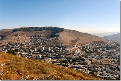
Mt Ebal and Shechem from Mt Gerizim, tb070507676

Mt. Ebal, view north from Mt. Gerizim, July 2007

Our route took us back through the valley, and we resolved that while passing between the two mountains of Ebal and Gerizim, in the still morning air, we would try the experiment of reading the blessings and curses. It will be remembered by the reader that, in compliance with directions given before the death of Moses, Joshua assembled all the people on these two mountains, stationing six tribes on one, and six opposite to them on the other, and he stood between and read to them all the blessings and curses of the law (See Deut 27-28, Josh 8:30-35). It has been urged by some skeptics that it was impossible for Joshua to read so as to be heard by the whole multitude of Israel. It is a sufficient answer to this to show that while Joshua read, the Levites were directed to repeat the words “with a loud voice” (Deut 27:14), and that it was an easy matter to station them at such points that their repetitions, like those of officers along the line of a marching army, could carry the words to the utmost limits of the multitude. But it is interesting to know that the spot chosen by God for this reading is a vast natural amphitheatre, in which the human voice can be heard to a surprising distance. About half-way between Shechem and the mouth of the valley in which it stands there is a deep, semicircular recess in the face of Mount Ebal, and a corresponding one precisely opposite to it in Mount Gerizim. No man with his eyes open can ride along the valley without being struck with this singular formation. As soon as I saw it I recognized it as the place of Joshua’s reading. It has been asserted repeatedly by travelers that, although two men stationed on the opposite slopes of these two mountains are a mile apart, they can read so as to be heard by each other. We preferred to try the experiment in stricter accordance with Joshua’s example; so I took a position, Bible in hand, in the middle of the valley, while Brother Taylor and Frank, to represent six tribes, climbed halfway up the slope of Mount Gerizim; and Brother Earl, to represent the other six tribes, took a similar position on Mount Ebal. I read, and they were to pronounce the amen after each curse or blessing. Brother Taylor heard me distinctly, and I could hear his response. But Brother Earl, though he could hear my voice, could not distinguish the words. This was owing to the fact that some terrace-walls on the side of the mountain prevented him from ascending high enough, and the trees between me and him interrupted the passage of the sound. The experiment makes it perfectly obvious that if Joshua had a strong voice,–which I have not,–he could have been heard by his audience without the assistance of the Levites. As to the space included in the two amphitheatres, I think it ample to accommodate the six hundred thousand men with their families, though of this I cannot be certain. If more space was required, the aid of the Levites was indispensable.”

UPDATE: Biblical Studies and Technological Tools has found and posted better images of the natural amphitheater, using Google Earth, HolyLand 3D and Microsoft Virtual Earth.
Share: