fbpx

Wayne Stiles wonders why the largest ancient site in Israel has been largely forgotten today.

Leen Ritmeyer provides context to the recent excavations of the “gate of hell” in Hierapolis.

On April 1, Luke Chandler revealed a stunning new translation of the Khirbet Qeiyafa Ostracon.

Few tourists are visiting Egypt these days and it’s hurting many who work in the industry.

Travel Weekly recommends how to spend a day visiting the harbor city of Jaffa (biblical Joppa).

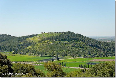
A review of the new excavations of Azekah is available in a professionally-made 12-minute video.

HT: Charles Savelle, Jack Sasson

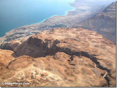
Azekah from northeast, tb030407700
Azekah from the northeast
Photo from the Pictorial Library of Bible Lands
Share:

Information on the second Qeiyafa inscription coming later this year (Luke Chandler)
The Tel Burna Arch
aeological Project (ASOR Blog)

Israel approves drilling for oil in Golan Heights (Jerusalem Post)

John the Baptist: The First Christian Martyr (Bryant Wood)

Review of The Unsolved Mystery of Noah’s Ark (Gordon Franz and Bill Crouse)


NIV Study Bible for Kindle marked down to $6.64 (Amazon)

Ferrell Jenkins has begun a series on famous people buried in the Protestant Cemetery on Mount
Zion, including Horatio G. Spafford and James Leslie Starkey.

Online Battle Over Sacred Scrolls, Real-World Consequences (New York Times) Includes an interview with Raphael Golb.

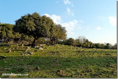
Oak forest on Golan Heights, tb020506169
Oak forest on Golan Heights
Photo from Galilee and the North
Share:

The Gezer Excavation Project includes a major regional survey under the direction of Eric Mitchell.

A preliminary report of the first five seasons (2007-2011) has now been published in Hadashot Arkheologiyot. Some excerpts:


Purpose: “The purpose of the project is to carry out a systematic high resolution archaeological survey of the region, within 1 km of Tel Gezer, and to locate and publish all features therein. This survey will aid in gaining a better understanding of the historical development of relationship between the ancient city of Gezer and its surrounding landscape.”


History: “The immediate vicinity of Tel Gezer has been investigated by R.A.S. Macalister who noted over 200 archaeological features within 1.5 km of the tell (Macalister 1912 III: Pl. VIII). In recent years, A. Shavit conducted a survey of the entire Gezer Map. Shavit noted that his survey was intensive but he was selective in the surveyed areas.”


Methodology: “To date, 1260 features have been recorded during the current investigations. Features are defined as any individual cultural element deposited on, built on, or carved into the landscape.

Therefore, with features such as winepresses, which include a basin, vat, channel, and cupmarks, each individual feature was added to the total and thus, the number of sites can be reduced significantly.”


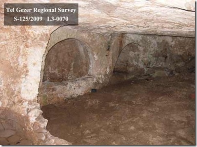
Tombs: “Forty-one tombs were accessible for interior survey. Seven basic categories of tomb type have been encountered during the survey. These include tombs with irregularly shaped interior plans (6), simple bench-style tombs (4), arcosolium or recessed bench tombs (5), a distinct simple double arcosolia type (5), loculus or kokhim tombs (9), tombs with multiple styles (3), and tombs that are incomplete, partially filled, or otherwise do not fit into the above categories (9).”


Surface Visibility: “While modern and old disturbances could have easily hidden the existence of tombs, caves, and presses where agricultural land now stretches, the ploughed fields and orchards now offer excellent surface visibility and provide ample opportunity to observe and collect pottery, tesserae, and chert flake scatters, which would otherwise have been obscured by dense brush.”


Conclusions: “The results of the 2007–2011 Tel Gezer Survey seasons have been encouraging in terms of both artifacts and features documented, as well as total area covered. At the current rate, it is estimated that two to three additional seasons will be necessary to complete surveying a 1 km radius around Tel Gezer. Our goal for the future is to publish a catalog of features within our survey area, as well as articles on the tombs and presses of Tel Gezer. At the end of the project, we will analyze all our GPS location data for features and artifacts from every season via mapping software. Using this data, we can construct a clearer understanding of distribution patterns for various features, as well as draw wider conclusions about the use of the land around the ancient city of Gezer.”

The full report includes five images. Check out the official website for information about joining the team.

gezer-tomb
View of arcosolia in Gezer tomb
Photo by Tel Gezer Regional Survey
Share:

A cave above En Gedi is revealing well-preserved artifacts from the first century AD.

Luke Chandler has word that Yosef Garfinkel plans to follow his Khirbet Qeiyafa dig with excavations at Lachish.

The Daily Mail has photos of the newly opened exhibit of King Herod at the Israel Museum. Shmuel Browns has more.

Some are claiming that the Waqf is destroying more antiquities on the Temple Mount.

Gordon Franz evaluates Robert Cornuke’s use of a computer model to predict the location of Paul’s shipwreck on Malta.

A website for the excavations of Tel Abel Beth Maacah is now online.

En Gedi and Nahal David aerial from northwest, tb010703272
Aerial view of Nahal David and En Gedi
Share:

The Times of Israel takes its readers into the new Herod exhibit at the Israel Museum one week ahead of its opening. The article includes many photos, but may be slow loading.

Wayne Stiles has put together some great visual resources of Caesarea, including photos, video, map, and Google Street View.

City Lights over the Middle East – NASA has posted a short video taken from the International Space Station.

Air pollution has been a problem since the days of ancient Rome.

The Oriental Institute has launched its Integrated Database. Phase II will include images.

Metro publishes the “Top 10 archaeological finds of all time.”

Yosef Garfinkel will be lecturing on “Sanctuaries and Cult at Khirbet Qeiyafa” at the Southern
Adventist University’s Lynn H. Wood Archaeological Museum Lecture Series.

Keith Schoville is retiring from The Book & The Spade radio program.

I am excited to announce that our photo collection Views That Have Vanished is now available as a
module for Accordance. The collection now has all the bells and whistles you would expect from Accordance.

HT: Daniel Wright, Aren Maeir, Charles Savelle, Jack Sasson

views-vanished-bivin-accordance
Screenshot from Views That Have Vanished
Share:

Bloomberg runs a story on the excavations at Tell Beth Shemesh, describing the recent discovery of a cultic site as well as the absence of pig bones.

We are standing in the middle of Israel on a quiet hill overlooking a fertile green valley.
Some 3,000 years ago, this peaceful place was right at the center of conflict, says archaeologist Shlomo Bunimovitz.
“The border lies somewhere between here and there,” he says, pointing to the west. He is co-leading excavations which have found the remains of a temple which was later desecrated and used as animal pens.
This is Tel Beth-Shemesh, the ancient meeting point of the Canaanites, Philistines and Israelites. The Bible describes it as the northern border of the Tribe of Judah. The area also features in the story of the return of the Ark of the Covenant, earlier captured by the Philistines. King Solomon ruled the district and it was the site of the battle between Joash and Amaziah, the respective kings of Israel and Judah.
“We are looking for evidence that this was a border, tangible evidence in the material culture that reflects this,” says Bunimovitz, from Tel Aviv University.
[…]
He produces plastic-covered charts that show how as excavations moved eastward, there were less remains of decorative Philistine pottery and a complete disappearance of pig bones.
“The Philistines wanted this fertile valley,” Bunimovitz says, “but had this pain in the neck here at Beth Shemesh.”
Before the Philistines settled, the Canaanites did eat a little pork, he says. Then they seemed to want to set themselves apart from newcomers and maintain a distinct culture.
“There is a modern example of this, in the wearing of keffiyehs (headscarf),” he says. “Israelis always wore them until Yasser Arafat adopted it. Now you won’t see any Israelis with it. Suddenly the keffiyeh becomes an ethnic marker.”

The full story includes more illustrations. The most striking contrast on the chart below is between Timnah and Beth Shemesh, located only 5 miles (8 km) apart. In the time of the judges, Beth Shemesh was an Israelite city and Timnah was Philistine (Judg 14:1; 1 Sam 6:9).

HT: Joseph Lauer

pig-bones-in-iron-age-i-philistia-highlands-beth-shemesh-excavations-bloomberg
Comparison of percentage of pig bones found at sites in ancient Philistia compared with ancient Israel. Source: Beth Shemesh Excavations via Bloomberg.
Share:
About the BiblePlaces Blog

The BiblePlaces Blog provides updates and analysis of the latest in biblical archaeology, history, and geography. Unless otherwise noted, the posts are written by Todd Bolen, PhD, Professor of Biblical Studies at The Master’s University.

Notice

As an Amazon Associate we earn from qualifying purchases. In any case, we will provide honest advice.