fbpx

Jezreel is one of my favorite biblical sites and I’m happy to see that excavations will begin again under the direction of Norma Franklin of Tel Aviv University and Jennie Ebeling of the University of Evansville. A new website has the details.

The Sea of Galilee dropped nearly a foot last month and is now 17 inches below the red line.

Shmuel Browns went on a Photo Walk in Jerusalem and would like our feedback in deciding which image he should submit to the competition.

Browns is also offering a free guided tour of Khirbet Qeyiafa on October 14 at 9 am.

A volunteer at the Gezer excavation this summer writes of her experience on the ASOR blog, noting that they ended the season on what they believe is a 10th-century floor.

The Virtual Amarna Project is now online. “This archive resulted from the 3D digitisation of objects from the ancient Egyptian city of Amarna using a Konica Minolta Vivid 9i system. Data includes images, 3D PDF files, meshes (obj) and point clouds (ascii).”

Another resource is the Amarna Tablet Photograph Database Online where you can view the inscriptions held by the Vorderasiatisches Museum of Berlin.

Aaron Burke is interviewed about the excavations in Jaffa (Joppa) on the LandMinds radio show (part 1, part 2).

Jimmie Hardin will be lecturing on the archaeology of David and Solomon at the University of Mississippi on October 26.

One million visitors viewed the Dead Sea Scrolls in their first week online.

HT: ANE-2, Jack Sasson

Share:

Several years ago I began a study on the location of Eshtaol that was interrupted by a leg injury. Last week I had the occasion to conclude the research and summarize it for another project I’m working on. While this is a bit more technical than most of the blog fare here, there are some insights that may be of interest, even if you are not so concerned with the location connected with the birth and burial of Samson (Judg 13:25; 16:31)

The reason for this study is to reveal a confusion about the site location of Eshtaol that has developed in recent literature. As you will see below, the site of Eshtaol has been “moved” without the guilty parties apparently being aware of what they were doing. This brief review may serve to identify failures in the process and encourage careful work in future study of this and other sites.

1. Michael Avi-Yonah was not the first involved in the identification of this site, but he is a convenient starting point for the purposes of this study. He believed that Eshtaol was located at Tell Abu el-Qabus (Kh. Deir Abu Qabus) on the hill above the Arab village of Ishwa, and he noted that Iron Age remains were found at the site (Encyclopedia Judaica, 1st ed., 6: 280).

2. In 1983, Anson Rainey agreed with Avi-Yonah’s identification, noting that Ishwa preserves the name of Eshtaol, just as many modern names in the Shephelah preserve the ancient ones (“The Biblical Shephelah of Judah,” BASOR 251: 7).

3. In 1986, Zechariah Kallai rejected Deir Abu el-Qabus on grounds that “the finds are incompatible,” preferring instead Kh. Deir Shubeib (Historical Geography of the Bible, 368). Kh. Deir Shubeib is located 1.6 miles (2.7 km) northwest of Tell Abu el-Qabus.

4. In a brief article in the Anchor Bible Dictionary (1992), Raphael Greenberg likewise identified Eshtaol with Khirbet Deir Shubeib, but he was imprecise in claiming that it is “near the village of Ishwa, which retains elements of the ancient name” (2:617).

5. Aaron M. Gale, writing in the Eerdmans Dictionary of the Bible (2000), confused the two sites, identifying Eshtaol with Khirbet Deir Shubeib, but locating it at the site of Tell Abu el-Qabus, 1.5 miles east of Zorah, near Ishwa (425).

6. Rainey in The Sacred Bridge (2006) apparently followed Greenberg/Gale in this mistake, as he writes, “Eshtaol is evidently to be located at Khirbet Deir Shubeib beside the village of Ishwa‘” (141). Kh. Deir Shubeib is 1.8 miles (3 km) west of Ishwa; Tell Abu el-Qabus is next to Ishwa.

On the basis of the observations above, some conclusions may be suggested:

1. Greenberg’s brief article made it unclear that there were two candidates and his imprecision led to later confusion.

2. Gale combined data from the ISBE and ABD articles and in doing so he incorrectly gave the name of Khirbet Deir Shubeib to the site of Tell Abu el-Qabus.

3. Rainey perpetuated Gale’s mistake in his 2005 work. Because The Sacred Bridge will be the standard reference work for historical geographers for the next generation, this mistake may live a long life.

4. The site of Eshtaol has “shifted” not because of convincing evidence but because of careless research and writing.

5. The identification of Eshtaol at either of the sites must be determined on the basis of archaeological study of the two proposed sites. It is doubtful, contrary to initial impressions, that Rainey was intending to follow Kallai’s identification over Avi-Yonah’s. Without further archaeological data, we prefer the conclusion of Avi-Yonah and the initial conclusion of Rainey that Eshtaol is located in the immediate vicinity of the Arab village that preserves its name.

The map below was made by British Mandate authorities, with Israeli additions in purple. The two sites in question are clearly identified. Google Earth users can find Kh. Deir Shubeib at 31.798000°, 34.985200° and Kh. Deir Abu Qabus at 31.785790°, 35.009930°.

My thanks to A.D. Riddle for his assistance with this study.
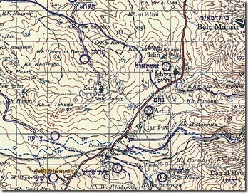
Eshtaol candidates

The vicinity of biblical Eshtaol in the eastern end of the Sorek Valley
Share:

Corrections and Updates to “Identifying Biblical Persons in Northwest Semitic Inscriptions of 1200-539 B.C.E.”

This article updates the cutoff point for the inscriptions treated in the book mentioned in the title, which was mid-2002, to July 31, 2008. It evaluates 32 proposed identifications (IDs) of biblical persons in ancient Near Eastern inscriptions of 1200-539 B.C.E. All 32 IDs or non-IDs are listed and indexed at the end.

Shmuel Browns explains the significance of Khirbet Qeiyafa and concludes with a report of Israel Finkelstein’s paper on the Large Stone Structure and the Stepped Stone Structure in the City of David. He dates the SSS to both the Iron Age and the Hellenistic period.

An ancient shipyard near Rome is being excavated.

Dan Brown and the Grail That Never Was. Paleobabble posts a link to a scholarly article that is “a succinct, readable dismantling of Brown’s bogus history.”

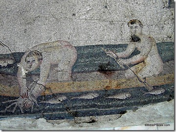
Antioch on the Orontes was a significant city in the early church. Today known as Hatay, the city’s museum boasts some impressive mosaics and other finds. But most is in storage until a new museum is built.

The new museum is to have the capacity to host 800 people at a time and 10,700 square meters of exhibition space.
Visitors who come to the Hatay museum can see around 906 square meters of mosaics at this point, though around 300 square meters are still in the museum’s warehouse due to space shortages. In fact, the museum’s total holdings include 35,433 pieces, but only 1,425 of these are on display due to serious space problems.
With pieces from the Hittite, Hellenic, Byzantine and Roman eras on display, the Hatay Archeologicy Museum was always known as the second most significant mosaic museum in the world, following Tunisia’s Bardo Museum. That is, until last week, when the Gaziantep Zeugma Mosaic Museum opened, and the Hatay Archeologicy Museum dropped to third place for mosaics.

I’m surprised the Medeba Museum in Jordan is not ranked in the top three.

HT: Jack Sasson

Nude fishermen mosaic, 5th c AD, tb122900316

Nude fishermen mosaic in Antioch (Hatay) Archaeological Museum
Share:

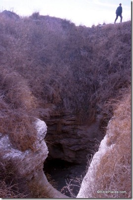
Two articles (at one link) describe this summer’s excavation of Gezer’s ancient water system, alleged to be the largest in all of Israel. The reports are lengthy and only a few excerpts will be given here. See the full articles for more details and photographs. Fans of the bumbling Robert Alexander Stewart Macalister will not be disappointed.

It is believed the Canaanites cut the massive tunnel around the time of Abraham using flint tools. Measuring nearly 13 feet wide by 24 feet high at the opening and stretching 150 feet into the ground at a 38 degree slope, the Gezer tunnel is the largest ancient water system ever unearthed. Late in the last week of the 2011 dig, the NOBTS team found the natural cave at the end of the massive rock-hewn water system — the prime objective of this season’s dig. It is believed that the system’s original water source is located in or near the opening of the cave. […] During next summer’s dig, scheduled for May 27-June 15, the New Orleans team will focus on excavating the cave in hopes of answering several lingering questions about the water system. First and foremost, the team will try to discover how the Canaanites knew about the water source. Warner believes the Canaanites found the water source through an opening in the cave located outside the city walls. He speculates that the tunnel was cut to provide the city with a safe water source during times of siege….Another question involves the date of the tunnel’s construction. […] After slowly digging through the rocks for a day and a half, the team reached the cave on June 7. It was 15 feet deeper into the water system than Macalister had recorded. The cave was filled to the top with fine, muddy silt. The last two days of the dig were spent cutting a 3-foot by 17-foot trench into the cave silt, readying the site for the 2012 dig. The final statistics from this summer are helpful in understanding the massive scope of the dig. According to Parker’s calculations, the team removed 231 tons of debris (1,372 bags) in 17 days of digging. Warner and Parker’s smaller 2010 team removed 68 tons of debris.

The full reports are here. HT: Joseph Lauer Gezer water system, tbs102149811

Share:

Timna Park, 20 miles (32 km) north of Eilat, has benefitted from a multi-million dollar spending spree, resulting in the creation of four new bicycle paths, hundreds of shade trees, and talk of a new hotel. The article says not a word about the best attraction of the park: the life-size model of the tabernacle.

In a BAR editorial, Aaron A. Burke describes how his detective work in the records of a deceased archaeologist revealed more about the city of Joppa (Jaffa) and cleared the archaeologist of claims of misdeeds.

At the Bible and Interpretation, Paul V. M. Flesher describes what a synagogue of Jesus’ time looked like.

CITYsights takes viewers on a one-minute video tour of Solomon’s Quarries (Zedekiah’s Cave) in
Jerusalem. The audio track consists of music only and if you turn the volume off, you’ll enjoy it more.

The Jerusalem Post has more details of Jerusalem: IMAX 3D, slated for release in 2013.

The headline of this Arutz-7 story would lead you to believe that it is about Ein Gedi, but it is primarily about the synagogue at the site.

BibleX notes that the Biblical Archaeology Society has 17 free e-books (with login/registration).

A group in Jordan is threatening to sue Israel over its opening of a baptismal site on the Jordan River.

They claim that the Israeli site is located in Jordan.

A story about ancient graffiti in caves in Israel is accompanied by a six-minute video.

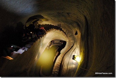
Wayne Stiles in the Jerusalem Post: “There’s much to see in the area of Tel Maresha and Beit Guvrin.

Remnants of pottery, war, industry, entertainment, and tombs—all gifts of archaeology.”

Bet Guvrin cave with staircase, tb022807547

Cave at Maresha/Beit Guvrin with ancient staircase
Share:

There is so much going on that I need to make an early start on the Weekend Roundup. There will be more tomorrow.

Ferrell Jenkins and Leon Mauldin are now traveling in Israel, with the goal of visiting places they have never seen before. Ferrell’s first post shows a well-preserved Roman road in the western hills of
Judah and Leon’s features a Roman milestone.

Shmuel Browns posts his list of “Top Ten” Jerusalem Sites. You might bring this list on your next visit to Jerusalem (or hire Shmuel to guide you around).

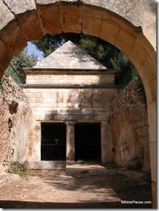
Joe Yudin guides his readers on a tour of significant tombs in Jerusalem, including “King David’s tomb,” the so-called family tomb of King Herod, the Muslim cemetery in Mamilla, and Jason’s
Tomb. I think an illustration or two would enhance the article.

A group of archaeologists and students in Israel have submitted a petition to lawmakers to drop support for a law that would allow the continuation of excavations in the City of David that are funded by Elad.

If you missed the “Office Hours” interview with Carol and Eric Meyers on Thursday, you may watch the video online. In the 50-minute interview, they discuss both professional and personal aspects of their lives in archaeology, including vandalism of sites, their children’s presence on digs, middle-of-the-night excavations, how to get a start in archaeology, and forthcoming books.

Reuters has a brief story about tunnel systems carved by rebels during the first and second Jewish
revolts.

Jason's Tomb through entrance arch, tb100102

Jason’s Tomb in Jerusalem
Share: