fbpx

Michael S. Heiser, at the Paleobabble blog, shares an article on limestone quarrying in Spain that may shed light on how similar activity was carried out in Israel. From the abstract:

It appears that one of the quarrying methods used was based on the chemical dissociation by fire of standing stone blocks at their  attachment points,a technique hitherto unknown or unreported in the literature.

Israel has its first crocodiles in the wild since the last one was shot in 1912. Fortunately the 50 escapees from the crocodile farm in the Jordan Rift have now been captured. Bonus question: where is the Crocodile River located in Israel?

Paul’s first preaching stop in what is today Turkey was at Perga (Acts 13:13). Archaeologists there are now celebrating 65 years of excavation.

An archaeological park has opened at Claros (Klaros), not far from Smyrna (Izmir).

The Jordan Times is reporting an uptick in the number of visitors to the “Bethany Beyond the Jordan” baptismal site.

Archaeological sites in Syria are apparently not faring well in the current bloodletting. The danger to Mari is noted in a recent story.

The Dead Sea Scrolls: A Full History, by Weston W. Fields, is reviewed by Jaqueline Du Toit. She writes,

“In conclusion, volume 1 of The Dead Sea Scrolls: A Full History is an inestimable contribution to scrolls historiography. It will appeal to scholars and students of biblical scholarship, but also to academia in general and a popular audience. Despite its price, which curtails its mass appeal, it is highly recommended. And, based on the riveting narrative still unfolding, volume 2 is awaited with great anticipation.”

Joe Yudin takes readers on a tour of part of the Old City of Jerusalem, focusing on remains of the Tenth Roman Legion. He gives a good tour but he makes a significant mistake in dating the Cardo to the Roman period. While the northern portion (beginning at Damascus Gate) was constructed by Hadrian, the southern portion was only built in the time of Justinian in the Byzantine period.

(Excavator Nahman Avigad was surprised to make this discovery in his excavations; he discusses it at length on pages 225-27 of the excellent Discovering Jerusalem. I was about to write this is a very difficult work to find, for indeed it was for many years, but now Amazon has used copies starting at $4.63. I’ve bought several over the years for $60.)

Wouldn’t it be nice to have a camera that lets you focus after you’ve taken the shot?

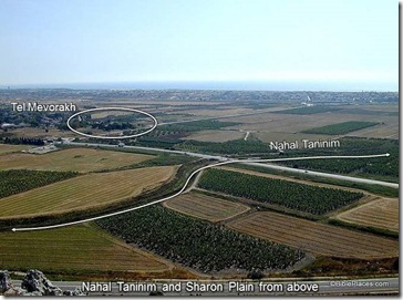
Answer to the crocodile question: the Nahal Taninim (Crocodile River) runs on the northern end of the Sharon Plain, just below Mount Carmel.

HT: Explorator, Joseph Lauer, G. M. Grena

Nahal-Taninim-from-Mount-Carmel-ppt-screenshot

Nahal Taninim and Sharon Plain from Mount Carmel
Share:

From the University of Arkansas:

The end of the third millennium B.C. – roughly 2200 to 2000 B.C. – is often described as a dark age because this period experienced the collapse of many major states, including the Akkadian Empire in Mesopotamia, Old Kingdom Egypt and the Harappan culture of the Indus Valley. Major cities and small towns across the Middle East that had been occupied for centuries were suddenly abandoned, leaving a gap in the archaeological and historical record.
“Tells” are the name for ancient cities and towns, preserved today as large mounds, throughout the Middle East. Until the 1980s, little was known about Tell Qarqur, the site of two large mounds that archeologists know was occupied continuously for more than 10,000 years, from 8500 B.C. to the medieval period. Tell Qarqur experienced particularly large occupations during the Bronze and Iron Ages, from 3000 to 500 B.C.
The researchers are now trying to understand why Tell Qarqur survived, when nearly all civilizations in the region during that time collapsed. Some anthropologists have attributed the demise of these settlements to widespread drought. If there was a drought, Casana said, the important question was how it affected the environment and ancient communities, that is, how susceptible were their agricultural strategies to drought and did they adapt to changing conditions? These are some of the questions Casana seeks to answer with continued research at the site.

The full press release is here, Live Science reports on the excavations here, and nine photos may be viewed here.

HT: Joseph Lauer

Share:

Hezekiah’s Pool is now clean, for the first time in decades if not centuries. Tom Powers gives the report and includes many photos. He suggests that the workers found a paved or plastered floor.

(Background here.)

Biblical Archaeology Society has a brand spanking new blog that includes an RSS feed and welcomes readers with a new 140-page ebook entitled the “Ten Top Biblical Archaeology Discoveries.” The new site also allows readers (upon sign-in) to control which email subscriptions they receive. The blog is part of a complete re-design of the BAS website.

Olof Pedersén has posted his list of ANE Placemarks for Google Earth.

Foreign Policy has posted a photo essay entitled, “Once Upon a Time in Damascus.” More than a dozen photos from the American Colony/Eric Matson collection are featured.

The work of Gustaf Dalman is being celebrated in a program to be held at the Austrian Hospice in Jerusalem on August 18-19. I’ve been working on publishing a Dalman project myself but I will not be finished in time for the 70th anniversary of his death.

Restoration work is scheduled to be restarted at the Stepped Pyramid of Djoser (Zoser) at Saqqara (with photo). The article notes that already a second successor to Zahi Hawass is in office.

The Pantheon in Rome may have been built as a massive sundial.

In recent weeks, Wayne Stiles has visited En Gedi and the Church of the Holy Sepulcher.

CBN News has a 30-second video of the tunnel where they discovered the Roman sword and etching of a menorah. Ynet News posts a two-minute video of the tunnel with English subtitles (to start you may need to click the smaller button on the right side of the screen).

HT: Charles Savelle, Joseph Lauer, Jack Sasson

Share:
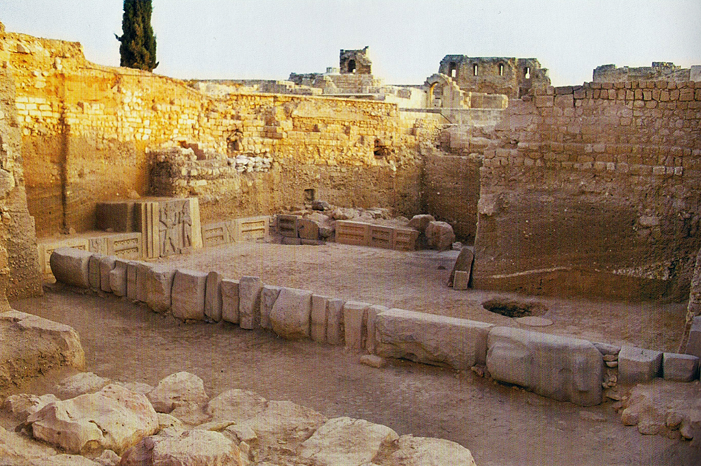
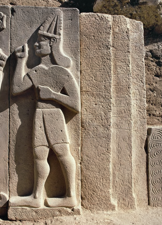
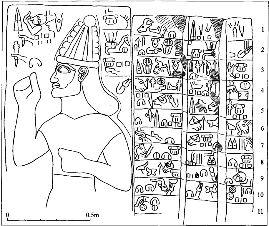
Taita was the ruler of a Syrian kingdom in the Iron Age II. His name appears in Hieroglyphic Luwian inscriptions found at Shaizar and Muhradah, Syria (adjoining towns on the Orontes River, about 13 miles northwest of Hamah) and in a Hieroglyphic Luwian inscription from the Storm-god temple found on the citadel of Aleppo, Syria. (A pdf guidebook by Julia Gonnella entitled The Citadel of Aleppo: Description, History, Site Plan and Visitor Tour, 2nd ed. [2008] can be downloaded for free here. Pages 8-9 and 37-38 show the location of the Storm-god temple and give a brief description.)

In the inscriptions Taita is said to be the “Walastinean hero/king” or “Palastinean hero/king.” This title also appears in Hieroglyphic Luwian inscriptions found at Tell Tayinat, in the Amuq Plain in Turkey. It has been suggested that Tell Tayinat was the capital of Taita’s kingdom and that it extended east to Aleppo and south to Hamath. See most recently J. David Hawkins, “Cilicia, the Amuq, and Aleppo: New Light in a Dark Age,” Near Eastern Archaeology 72/4 (2009): 164-173.

Fragment of a Hieroglyphic Luwian inscription from Tell Tayinat which mentions the “Walastinean king.” On display at the Oriental Institute Museum, Chicago.

The Luwian language is closely related to Hittite, Lycian, and other Anatolian languages. Luwian was written in both a cuneiform script and a hieroglyphic script, no relation to Egyptian hieroglyphs. Hieroglyphic Luwian was used by kings of the Hittite Empire for monumental inscriptions and seals.

After the fall of the Hittite Empire, Hieroglyphic Luwian continued to be used in the Neo-Hittite and Aramean kingdoms that emerged. In publications, the inscriptions are often named after the place they were found. For the Late Bronze Luwian inscriptions from the Hittite Empire period, see this list. For the Hieroglyphic Luwian inscriptions from the Iron Age, see the three-part volume by John David Hawkins, Corpus of Hieroglyphic Luwian Inscriptions (Berlin: Walter de Gruyter, 2000), aka CHLI. It is reasonably priced at Amazon, though if anyone would like to make a contribution towards my purchase of the set, I am accepting offers. Inscriptions found since the publication of CHLI are listed here. Two years ago, I made a map showing the distribution of Iron Age Hieroglyphic Luwian inscriptions which can be viewed here. It is now outdated.

Returning to Taita, Charles Steitler recently published an article in which he proposed Taita is To‘î, a king who paid tribute to David after David defeated Hadadezer, king of Zobah (2 Sam 8:9-11; 1 Chr. 18:9-11). To‘î is a Hurrian name, and Steitler argues Taita is also a Hurrian name. There is a -ta element in Taita’s name which does not appear in the name To‘î. Steitler is not able to give a definitive explanation for the significance of this element, and thus, we cannot say why it would have dropped out. (Steitler’s article is entitled “The Biblical King Toi of Hamath and the Late Hittite State of ‘P/Walas(a)tin,’ ” Biblische Notizen 146 [2010]: 81-99. It was noted by several blogs beginning I think with Aren Maeir.) There is also the difficulty of dating Taita’s inscriptions. In CHLI, Hawkins said the dating of Taita’s inscriptions was doubtful, but suggested the period 900-700 B.C. In the 2009 article I mentioned previously above the photo, Hawkins now suggests a possible date between the 11th and 10th centuries B.C. So it is hard to know right now if Taita was King To‘î of the Bible.

Benjamin Sass has now written two pieces, one here and more recently, “Four Notes on Taita King of Palistin with an Excursus on King Solomon’s Empire,” Tel Aviv 37 (2010): 169–174. He suggests dating Taita to around 900 B.C. for the main reason that, for Sass, this paints a more satisfying historical picture.

Last month, Brian Janeway contributed a summary of these findings as well. It can be read here.

If these recent discussions are any indication, we can expect that Hieroglyphic Luwian inscriptions will more-and-more play a significant role in our reconstructions of the early Iron Ages. Kenneth Kitchen has already written a couple of essays in which he shows how these inscriptions are an important source of new information for understanding King David’s kingdom.

Kitchen, Kenneth A.
2002 “The Controlling Role of External Evidence in Assessing the Historical Status of the Israelite United Monarchy.” Pp. 111-130 in Windows into Old Testament History: Evidence, Argument and the Crisis of “Biblical Israel.” Ed. V. P. Long, D. W. Baker, and G. J. Wenham. Grand Rapids: Eerdmans.

2005 “The Hieroglyphic Inscriptions of the Neo-Hittite States (c. 1200-700): A Fresh Source of Background to the Hebrew Bible.” Pp. 117-134 in The Old Testament in Its World: Papers Read at the Winter Meeting, January 2003 The Society for Old Testament Study and at the Joint Meeting, July 2003 The Society for Old Testament Study and Het Oudtestamentisch Werkgezelschap in Nederland en België. Ed. R. P. Gordon and J. C. de Moor. Leiden: Brill.

2010 “External Textual Sources — Neo-Hittite States.” Pp. 365-368 in The Book of Kings: Sources, Composition, Historiography and Reception. Supplements to Vetus Testamentum 129. Ed. B. Halpern and A. Lemaire. Leiden: Brill.

And this is for that last reader who is not yet bored to tears. For more reading, probably the best place to start is Near Eastern Archaeology 72/4 (2009). The entire issue is dedicated to Taita, Tell Tayinat, and the Aleppo Storm-god temple. For more information on Luwians and the Luwian language, one might pursue:

Melchert, H. Craig, ed.
2003 The Luwians. Leiden: Brill.

Payne, Annick.
2010 Hieroglyphic Luwian: An Introduction with Original Texts. 2nd revised ed.Wiesbaden:
Harrassowitz.

UPDATE: I received today the latest issue of Biblical Archaeology Review. The cover story is an article by Victor Hurowitz in which he identifies similarities between the Aleppo Storm-god temple, two temples excavated at Tell Tayinat, and Solomon’s temple. See Victor Hurowitz, “Solomon’s Temple in Context,” Biblical Archaeology Review 37/2 (2011): 46-57 and 77-78.

Share:

This isn’t exactly breaking news, but I did not find any other blogs that had written about it, and it seems worthy of mention.

Back in September 2007, Turkish Daily News (now known as The Hürriyet Daily News and Economic Review) reported that operations to clear the land mines near the site of Carchemish had commenced. At the time, it was estimated the clean-up would take about one-and-a-half years. Todd mentioned it here.

As a follow-up to this story, it was reported last December in Today’s Zaman that the mines had been cleared and the land was now in the process of being turned over to the city. After bidding for the mine-clearing project, work actually commenced in March 2010. Three hundred days later, it was complete. Mine-sniffing dogs were used in the initial stages, and to avoid damaging antiquities, the mines were removed to another location for detonation (usually, mines are detonated on the spot). Now that the mines have been cleared, archaeologists will begin “serious and long-term” excavations, which it is hoped will attract tourism.

The site of ancient Carchemish is cut by the modern Turkey-Syria border. The citadel and inner town are located within Turkey, but most of the outer town is located in Syria. On the Turkish side is the modern village of Karkamiş and on the Syrian side is the village of Jerablus. As part of Turkey’s attempts to open up trade with its neighbors, plans are underway to open three new border crossings with Syria by 2012, one of which will be located at Karkamiş.


For an account of the earlier excavations conducted by Sir Leonard Woolley, see here.

Carchemish from the northwest, view of citadel and inner town wall.

Carchemish citadel from the northwest.
Share:

Construction of a new parking lot underneath the Jewish Quarter was reported to require the first breach of the Old City walls of Jerusalem in more than a hundred years.  Well, not quite.  First, the architect clarified that he was only going under the walls and not through them.  Then Leen Ritmeyer explained that the walls were not breached a hundred years ago for Kaiser Wilhelm II’s visit.  The walls are safe, for now.

A program on the “New Finds in Jaffa Gate” will be held on Oct 12, 2010, 6-8 pm at Jerusalem’s Yad Ben Zvi Institute.  Ofer Sion and Shahar Poni will lecture on the discoveries, including the channel leading to Hezekiah’s Pool.  The lecture notice (in Hebrew) can be found here and here (pdf). 

HT: Joe Lauer

A statue of Hathor disappeared from a temple at Serabit el-Khadim and was discovered in the Sinai desert five days later.  Authorities are questioning the site’s security guards.

Following Friday’s report that the Syrian army has a Scud missile base near Damascus, Jay Baggett (Land of the Bible) created a flyover tour to the “hidden” base where the missiles can be easily seen on Google Earth.

Steven Lancaster and James Monson have completed the Geobasics Study Guide, an outstanding and unique work that deserves a post of its own.  In the meantime, you can get a copy for yourself.  The guide is in pdf format and is free.  The accompanying map book is (only) $15.

Share: