fbpx

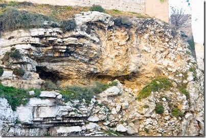
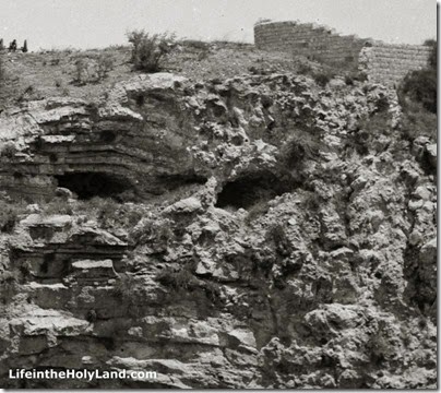
Visitors to the Garden Tomb of Jerusalem are usually shown the “Skull” identified by Charles Gordon as part of the case that this spot may be the authentic site of Jesus’ crucifixion and burial. On February 20 the bridge of the skull’s nose collapsed during a storm. Our friend Austen Dutton visited the site, alerted us to the event, and sent us this photo.

Gordon's Calvary near Garden Tomb, amd022115831

For contrast, here’s a photo taken in 2008.

Gordon's Calvary near Garden Tomb, tb051608027

Visitors to the Garden Tomb are shown the passage that identifies the place of Jesus’ death as “the place of the Skull.”

“Carrying his own cross, he went out to the place of the Skull (which in Aramaic is called Golgotha)” (John 19:17).

It is worth noting that the Gospels never explain why the place was identified by a skull, nor does it say anything about a hill. The name could have come from a geological feature that bore this resemblance. Or it could have been for another reason altogether.

The recent storm and the resultant erosion suggests that the escarpment would have been greatly altered in the years since it was created by quarrying. I would consider it doubtful that anything like the skull-shape visible in recent years was known in the first century. Fortunately for those who prefer the Garden Tomb location, this has never been the primary support for its identification.

Gordon's Calvary showing skull, mat00918
Gordon’s Calvary in 1910s

Our Jerusalem volume in the American Colony and Eric Matson Collection has a section devoted to the Garden Tomb. In notes written by Tom Powers, he provides some of the fascinating background to the identification of the skull.
General Charles Gordon, spending several months in Jerusalem in 1883, became firmly convinced that the hill seen here was the Golgotha of the New Testament. The idea of Skull Hill as Golgotha was not original with him, however, as several earlier travelers and writers had proposed the same identification beginning as early as the 1840s, and Gordon certainly knew of some of these. Among the other proponents of this view was Claude Conder, a Palestine Exploration Fund explorer and surveyor who was sent to Palestine in 1872 and recorded the idea in two of his books, Tent Work in Palestine (1878) and The City of Jerusalem (1909).

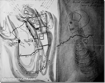
Gordon, however, added his own unique, mystical notions to the theory, however, based in part on both topography and Biblical typology. He believed, for example, that because sacrificial animals were slaughtered in the ancient Jewish temples north of the altar, according to the Mishnah, that Jesus must have been crucified north of the city. Further, Gordon devised a conceptual scheme by which he superimposed a human skeleton on a map of Jerusalem. The skull, not surprisingly, fell on Skull Hill (and he even pinpointed the human figure’s esophagus, a known water channel that entered the city beneath the north wall)!

Plan of Gordon's Idea of Calvary, mat01364
Plan of Gordon’s Idea of Calvary

Gordon added at least one other unusual aspect to the Skull Hill speculations: Being a military man, he consulted a detailed map of the area, the Ordnance Survey Plan of Jerusalem, and was struck by a particular contour line—2549 feet (797 m) above sea level—which, encircling the summit of “Skull Hill,” formed what looked to him like the outline of a human skull. Mention is sometimes made, somewhat derisively, of a revelatory dream or vision that Gordon had, but this seems not to be mentioned in the general’s own writings nor in contemporary accounts.

Gordon expressed his views in a flurry of letters and reports sent to various acquaintances and colleagues, including many to Conrad Schick and many others to Sir John Cowell in England, comptroller to the royal household. General Gordon was a hugely popular figure in his day, the perfect embodiment, one might argue, of military heroics, fervent Christian faith, and Victorian Romanticism, and after his death in Khartoum in 1885 his stature and fame only grew, if that were possible. In any event, there is no denying that the force of his personality provided an important impetus toward the acquisition, development and promotion of the Garden Tomb site, and did much to cement its credentials in the popular imagination.

Bertha Spafford Vester, daughter of American Colony founders Horatio and Anna Spafford, recounts her childhood memories of the famous General Gordon (1882–83):

“Five is not too young for hero worship, and my hero was a frequent visitor to our house, General Charles George ‘Chinese’ Gordon, ‘the fabulous hero of the Sudan’. He was fulfilling a lifelong dream with a year’s furlough in Palestine, studying Biblical history and the antiquities of Jerusalem. This was the only peaceful time the general had known in many years, and it was to be his last. . . . The general lived in a rented house in the village of Ein Karim . . . and General Gordon came often from his village home to Jerusalem riding a white donkey. . . . Whenever General Gordon came to our house a chair was put out for him on our flat roof and he spent hours there, studying his Bible, meditating, planning. It was there that he conceived the idea that the hill opposite the north wall was in reality Golgotha, the ‘Place of the Skull’ . . . He gave Father a map and a sketch that he made, showing the hill as a man’s figure, with the skull as the cornerstone. Part of the scarp of the rock of what is known as Jeremiah’s Grotto made a perfect death’s-head, complete with eye-sockets, crushed nose, and gaping mouth. Ever since then this hill has been known as ‘Gordon’s Calvary,’ although archaeologists are skeptical on the subject . . . Father did not agree with all the general’s visionary ideas, but he liked to talk about these and many other subjects with him, and they were good friends. Mother wanted General Gordon to have peace when he was meditating on the roof, and cautioned me not to disturb him, but I would creep up the roof stairs and crouch behind a chimney; there I would wait. I watched him reading his Bible and lifting his eyes to study the hill, and my vigil was always rewarded, for at last he would call me and take me on his knee and tell me stories.” — Bertha Spafford Vester, Our Jerusalem: An American Family in the Holy City, 1881-1949 (Ariel, 1988), pp. 102-3.

Gordon's Calvary from city wall, mat00919
Gordon’s Calvary from wall of Jerusalem’s Old City (1910s)
Photos from The American Colony and Eric Matson Collection
Share:

(Post by Seth M. Rodriquez)

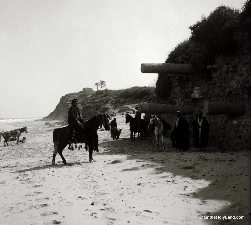
This week we focus our attention on the site of the first excavation in Palestine. When and where did this event take place? According to Neil Asher Silberman in his fascinating book Digging for God and Country, the year was 1810 and the site was Ashkelon.

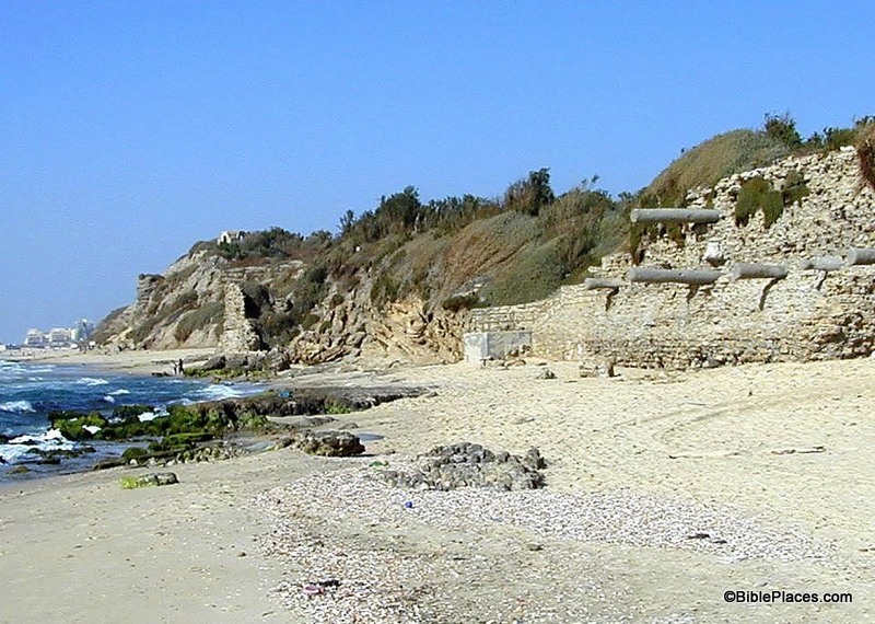
We actually have two pictures this week: one is from Volume 4 of the Pictorial Library of Bible Lands, and the other is from Volume 3 of The American Colony and Eric Matson Collection. The first image is how this site looked around 1910 or 1920 (a hundred years after the first excavation) and the second image is how the site looked in 2001 (almost two hundred years after the first excavation).

Both pictures were taken from almost the exact same spot. Notice the same set of columns protruding from the cliff in each picture. (Apparently the horses were unavailable for the photo op in 2001.)

On pages 24 to 27 of Digging for God and Coutnry, Silberman tells the fascinating story of an eccentric woman named Lady Hester Lucy Stanhope. She came from a prominent family in England and so was a lady with some means. She attempted to put that wealth to good use by pursuing exploration in the Middle East.

After a daring visit to Palmyra in 1810, she received a copy of “an intriguing ancient document” from some Franciscan monks which “described a fantastic treasure of gold bullion said to have been secretly buried in the ruins of the ancient city of Ashkelon on the Mediterranean coast, giving precise details of its location.” After getting further proof from the monks that the document was authentic, she reached out to the British government to help her retrieve the treasure, but (unsurprisingly) she was turned down. The story continues…

Sending word of her intentions directly to the sultan in Constantinople, Lady Hester began the journey down the coast to Ashkelon…. Arriving at the ruins of the Philistine city, Lady Hester settled into a comfortable cottage in a nearby village and conscripted hundreds of local fellahin to begin the work of excavation. The treasure map indicated that the gold was buried beneath a ruined mosque, and it was there that the digging began.

At the end of the fourth day of excavation, several huge pillars were discovered lying side by side as if to conceal a secret hiding place. The sultan’s representative hastily summoned special winches and ropes, but as the huge stone cylinders were lifted and removed, it became clear that the treasure they concealed was of neither silver nor gold.

It was the huge headless statue of a Roman emperor—the first archaeological artifact ever discovered by excavation in Palestine.

But beneath the statue was nothing, and Lady Hester was seeking gold, not classical art.

Ordering the statue to be set upright—and out of the way—she ordered the workers to resume digging for the treasure at another part of the site.

After several more weeks of excavation, a maze of empty trenches and haphazard piles of overturned earth testified grimly to the fruitlessness of the search…. Rather than admit to herself that the treasure map was a hoax, she became convinced that the late al-Jazzar had himself removed the treasure only a few years before. All that was left to her was the Roman statue.

Lady Hester was determined to demonstrate, however, that unlike other British antiquarians she had no interest in filling a museum; her search had been undertaken unselfishly, with regard only for the friendship of the Ottoman ruler. She had seen for herself the aftereffects of Lord Elgin’s removal of the Parthenon frieze while in Athens several years before, and she did not want her excavations to encourage similar plundering in the Holy Land. With a wave of her hand, she ordered the workers to destroy the monumental statue and cast its fragments into the sea.

With that act, Lady Hester Stanhope ended her brief but memorable archaeological career…. 

Wow. How times change. There’s a lot we could say about that first excavation, but I will content myself by saying that fortunately the current excavations are being carried out much more responsibly. But if you would like a piece of the first artifact ever excavated in Palestine, allow me to suggest a walk along the beach at Ashkelon looking for fragments of a Roman statue discovered (and destroyed) in 1810.

These photos and hundreds more are available in Volume 4 of the Pictorial Library of Bible Lands and Volume 3 of The American Colony and Eric Matson Collection. The former volume is $39 and is available here; the latter volume is $20 and is available here (both include free shipping within the U.S.). Additional photos and information about Ashkelon can be found here on the BiblePlaces website. The excerpts were taken from Neil Asher Silberman, Digging for God and Country: Exploration, Archaeology, and the Secret Struggle for the Holy Land, 1799-1917 (New York: Anchor Books, Doubleday, 1982), pp. 24–26, and is available for purchase here.

Share:

(Post by Seth M. Rodriquez)

From the legend of Atlantis to the recent ABC television series called Lost, disappearing islands have always fascinated people.  Modern history tells the story of another disappearing island, but unlike other stories, there is little mystery about why it happened.

Our picture of the week (the second image displayed below) comes from Volume 5 of The American Colony and Maston Collection which focuses on Egypt and Sinai.  To show the development of the site over the last century, I have also included a drawing from Picturesque Palestine, Sinai and Egypt and a photograph from the revised Pictorial Library of Bible Lands in this week’s post.

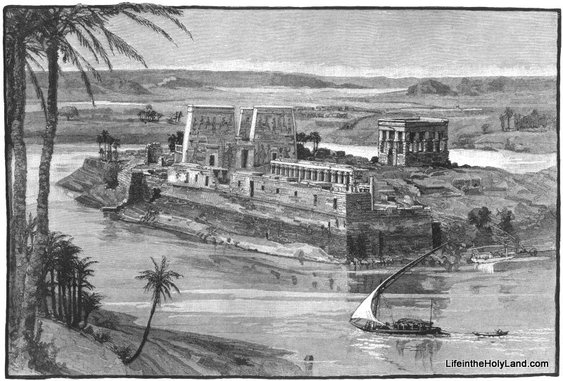
From the Roman Period until the late 19th century, the island sanctuary of Philae looked similar to the image below.  A temple to Isis was built on the site in the Roman Period and later was converted to a Christian worship site.

Philae in the 1800s

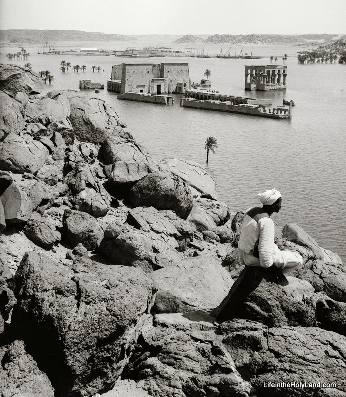
In 1898, the British constructed the Aswan Dam near the first cataract of the Nile.  The dam helped control the flow of the Nile River but it also flooded the area to the south, including the island of Philae.  The ruins of Philae were partially submerged, as can be seen in the photo below.  This photo was taken sometime between 1910 and 1920.  (Volume 5 of The American Colony and Eric Matson Collection includes a couple of pictures of the Aswan Dam when it was in use, and of tourists visiting Philae by boat.) 
Philae in the Early 1900s

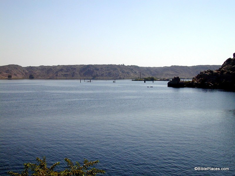
In the 1960s and early 1970s, the High Dam was built which raised the waterline even further.  So if you visit the area today, there is nothing left of the island of Philae.  Fortunately, the ruins on the island were dismantled and moved to the nearby island of Agilika, so you can still see the ruins of Philae … you just can’t see them in their original spot.

Philae Today

The photograph of the partially submerged ruins of Philae and over 450 others images of Egypt and Sinai are available in Volume 5 of The American Colony and Eric Matson Collection and can be purchased here for $15 (with free shipping).
The drawing of the island before the dams were built is from Volume 4 of Picturesque Palestine, Sinai and Egypt which can be purchased for $20 here (with free shipping).

The photo of Philae today is from Volume 7 of the Pictorial Library of Bible Lands, Revised and Expanded Edition which can be purchased here for $34 (with free shipping).

Additional images and information on Philae can be found here on LifeintheHolyLand.com and here on BiblePlaces.com.

Share:

(Post by Seth M. Rodriquez)

What is it about old photographs that make them so fascinating? 

I think part of the answer lies in our natural curiosity about the past.  What did things look like back then?  And to a student of archaeology, old photographs of archaeological sites can be especially fascinating because it raises the question: What did things look like when the first archaeologists stepped onto the scene?

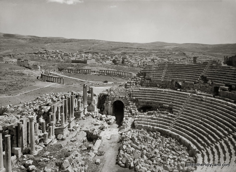
Our picture of the week comes from Volume 4 of The American Colony and Eric Matson Collection, which focuses on Lebanon, Syria, and Jordan. In the photo below, you can see the southern theater and the forum at Gerasa (a.k.a., Jerash) in the modern country of Jordan.  Gerasa was one of the cities of the Decapolis, and “the country of the Gerasenes” is mentioned in Mark 5:1, Luke 8:26, and Luke 8:37.

The photo was taken sometime between 1920 and 1933. Another early photograph of the forum can be found here on LifeintheHolyLand.com. By way of contrast, this page on BiblePlaces.com shows you what Gerasa looks like today, after the archaeologists have excavated, cleaned up, and reconstructed these ruins. The differences between then and now are striking.

The American Colony and Eric Matson Collection is a wealth of information and has a variety of uses:

  • For the archaeologist, this collection provides photographs of early digs and of sites as they looked before excavations. For better or worse, this was an age when a lone scholar stood over a team of local workers who moved tons of dirt in a single season (and this practice can be seen in the collection). Yet this was also a period when things were fresh and exciting as archaeologists were digging into sites for the first time.
  • For the preacher and teacher, this collection provides additional material which can be used to transport your listeners back to a culture and landscape similar to biblical times. It also can be used to discuss geography or illustrate particular sites.
  • For the historian, this collection provides windows into this dramatic period of history. This was the period of the late Ottoman Empire and the British Mandate when Jewish immigrants were migrating to Palestine and establishing new settlements. It was also a time when technology was on the rise: electric stations and telephone stations were being built, railroads were being constructed, and automobiles and airplanes were coming onto the scene.
  • For the artist and graphic designer, this collection provides many beautiful, crisp, black & white photos of places in the Holy Land that can be used in a variety of ways.  These photos still capture people’s attention and fire their imaginations.

This photograph and over 700 others are available in Volume 4 of The American Colony and Eric Matson Collection and can be purchased here for $20 (with free shipping).  Historic images of other Roman cities can be seen here, here, and here on LifeintheHolyLand.com.
Share:

(Post by Seth M. Rodriquez)

Why is it that the more important the biblical site, the more it tends to be surrounded by modern buildings?  Sites such as HazorMegiddo, and Gezer have a lower level of biblical significance (see 1 Kings 9:15) yet they are delightful places to visit because they are relatively untouched by modern developments.  But take a city like Jerusalem, Bethlehem, or Nazareth, and you need to hire a professional guide to help you find the ancient remains among the modern.

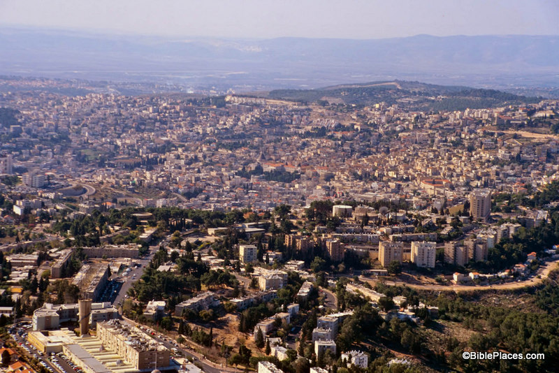
Take Nazareth for example.  I have been to Nazareth a number of times, but I have seen few (if any) ancient remains in that city.  It is completely covered by modern buildings.

Nazareth Today

This is not to criticize the modern inhabitants of the city.  They have a right to live there and build comfortable houses and reliable roads.  I am merely pointing out that often modern developments can diminish the usefulness of a location for teaching purposes.  This is why a site such as LifeInTheHolyLand.com and the resources available through that site are so helpful.

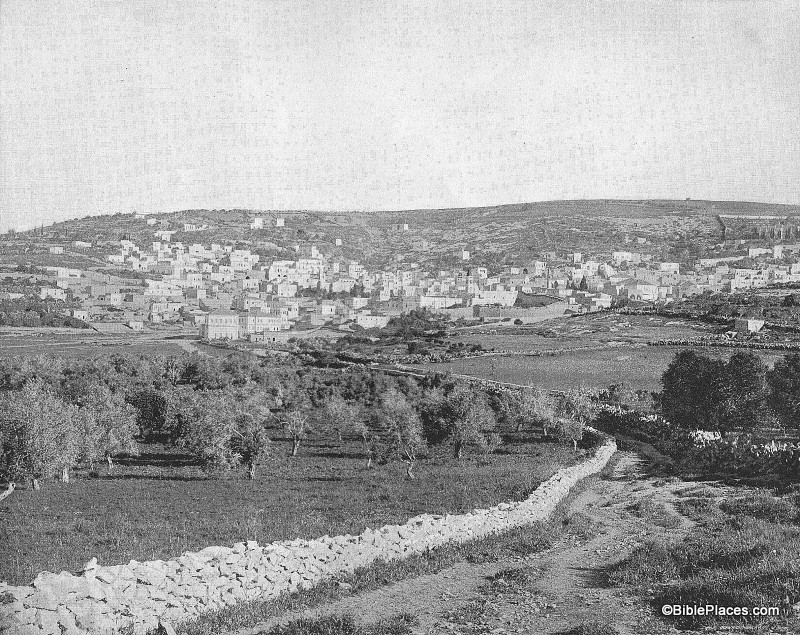
Our picture of the week comes from a book entitled Earthly Footsteps of the Man of Galilee, which has been reproduced in electronic form and is available through  LifeInTheHolyLand.com.  It contains nearly 400 photographs taken in 1894.  The book follows the life of Christ and the apostles chronologically, traveling back and forth through various countries.  Below is a picture entitled

“Nazareth from the East” and is followed by an excerpt from the book.  In this image, the city of Nazareth is much smaller than it is today.  The Nazareth of 1894 was probably much larger than the Nazareth of the 1st century, and yet this photograph provides a better impression of the Nazareth that Jesus knew than any modern photograph could hope to reproduce.

Nazareth in 1894

NAZARETH FROM THE EAST.–After an absence, according to Dr. Andrews, of something like six months, the Holy Family with the infant Jesus came in sight again of their own home.  If they approached the city from the East they would get the view, as far as the topographical features are concerned, given above.  Nazareth stands almost mid-way between the Jordan and the Mediterranean Sea, as we have already said.  It lies on the eastern slope of the hill, from the summit of which a magnificent prospect opens out.  Toward the north are the hills of Galilee and the majestic summits of the snow-crowned Hermon.  On the east is the Jordan valley and in dim outline the heights of the ancient Bashan.  To the south spreads the beautiful plain of Esdraelon, with Mount Tabor, Little Hermon and Gilboa; in sight, beyond, are the hills of Samaria, and on the west Carmel faces the blue waters of the Mediterranean.  No traveler should miss this view from the hill behind Nazareth.  It is perhaps the richest and most extensive in all Palestine.  The nearer hills are wooded, and drop in graceful slopes to broad and widening valleys of “living green.”  In the village below, upon this eastern slope, the Savior of the world passed his childhood.  His feet must frequently have wandered over these hills, and his eyes looked again and again from the summit as do the eyes of pilgrims now.  Here the Prince of Peace looked upon the great plain of Esdraelon, where had so often been heard the din of battle; and upon that sea over which the swift ships were to bear the tidings of his salvation to continents and nations then unknown.  The history of Nazareth seems to cluster about one remarkable event, “The Annunciation.”  Before that the place was unknown.  But to the Christian, Nazareth is the home of the Savior’s boyhood; the scene of his early labors, his prayers, his domestic relations, his whole private life for thirty years.  This gives unspeakable charm to the town.

Quote taken from John H. Vincent, James W. Lee, and R. E. M. Bain, Earthly Footsteps of the Man of Galilee (New York: N. D. Thompson Publishing, n.d.), p. 101, which can be purchased here.  The entire work contains almost 400 images, each with an explanatory note. Additional images of Nazareth can be seen here (1800s and 1960s) and here (modern day).

Share:

(Post by Seth M. Rodriquez)

Site identification can be tricky business.  Just because a Bible atlas or a scholar says that site X was once the ancient city of Y, doesn’t mean that you have to believe him.  Let’s look at an historical example.

Our picture of the week comes from Picturesque Palestine, Volume II: Samaria, Galilee, and Syria

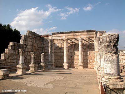
It is entitled “The Ruins of Tell Hum.”  Here you can see the ruins of an ancient synagogue as they appeared in the 1870s.  Today these ruins have been reconstructed and look like this:

Look familiar?  Chances are that if you have visited Israel, you have been here.  But today we don’t call it Tell Hum … we call it Capernaum.

In addition to digital pictures in this collection, there is also a full copy of the 1881 book in pdf files.  The book provide us with a window into the scholarship of the late nineteenth century, with all its related observations, conclusions, and debates.  At the time, the location of Capernaum was in question.  Today we are fairly certain that Tell Hum was the location of Capernaum.  Yet back in 1881, the site had not been excavated and it was a debated issue, similar to how other sites are debated today.  Unfortunately, the author of this section of the work was on the wrong side of the debate.  This is how the author argues against identifying Tell Hum with Capernaum:

Tell Hûm itself is so thickly overgrown with thistles and weeds of every kind, that at certain seasons it is almost impossible to get about. Among the ruins the absence of blocks of stone will be noticed, and instead, the extensive use of boulders in all the common houses. In fact, the ruins, as such, are of a very inferior kind. With the exception of what is thought to have been a synagogue, including a large building which at some time enclosed it, Tell Hûm has no ruins that would be worth visiting. The remains of this synagogue have been referred to as an evidence that Tell Hûm represents the site of Capernaum of the New Testament; but the preservation of these ruins is such as to justify the conclusion that they date from the second to the fourth century of our era, rather than from the time of Christ. Besides, Tell Hûm is two and a half or more miles from the point where the Roman road touched the lake, and hence would be a most unlikely place for a custom-house. It has no remains of a road or of a castle, and the unimportant character of the ruins has just been noticed. If Capernaum was here, it could have no possible connection with the plain of Gennesaret, which, we infer from the Gospels, should be the case. The place possesses no harbour, and in fact hardly a landing-place for a boat. This would be quite true in a storm, or at any time if the sea were very rough.  (Selah Merrill, “Galilee,” in Picturesque Palestine, Vol. 2, p. 86)

What Dr. Merrill says about the date of the synagogue is correct.  The synagogue from the first century was most likely torn down and replaced with this beautiful building that later fell into ruin.

But in the end it is a moot point and his other arguments have not withstood the test of time.  The general consensus today is that Tell Hum is the site of ancient Capernaum.

It is true that we have come a long way since the nineteenth century explorers were doing their pioneering work.  And yet, one has to wonder … What site identifications do we hold to today that will cause people in the next century to chuckle and shake their heads at our ignorance?  I guess that’s part of the appeal of archaeology.  There are so many mysteries still left to unravel.

This and other pictures of nineteenth-century Galilee are available in Picturesque Palestine, Volume II: Samaria, Galilee, and Syria and can be purchased here.  Additional historic images of the Capernaum can be seen here, and modern images of Capernaum can be found here.

Share:
About the BiblePlaces Blog

The BiblePlaces Blog provides updates and analysis of the latest in biblical archaeology, history, and geography. Unless otherwise noted, the posts are written by Todd Bolen, PhD, Professor of Biblical Studies at The Master’s University.

Notice

As an Amazon Associate we earn from qualifying purchases. In any case, we will provide honest advice.